India’s vulnerability to Disasters
- Categories
Disaster Management: the necessity of a country
- Published
1st Mar, 2022
-
Introduction
- India’s vast and variable geographical extent, diverse relief features coupled with climatic variations has made it vulnerable to different types of disasters.
- The whole country has been divided into six climatic zones namely, hot and dry, warm and humid, moderate, cold and cloudy, cold and sunny, and composite, each showing different characteristics and thus vulnerable to different types of disasters..
- On the one hand, the northern most parts of the country is vulnerable to avalanches, frost bite, debris avalanche and flash floods while the southernmost tip is prone to cyclone, sea-level rise and urban floods.
- The same is true for eastern and North-Eastern India which is prone to forest fires, mine collapses, over flooding e.t.c. and western sections which is prone to ground water salinization, landslides e.t.c. After all these challenges, India’s disaster management has evolved with time.
India’s vulnerability to disasters: Types and consequences
A. Earthquake
- In accordance with the history of earthquakes in the country, a total of ~59% of the land mass of India (covering all states of India) is prone to earthquakes of different intensities.
- As per the seismic zoning map of the country, the total area is classified into four seismic zones.
- Zone V is seismically the most active region, while zone II is the least. Approximately, ~ 11% area of the country falls in zone V, ~18% in zone IV, ~ 30% in zone III and remaining in zone II.
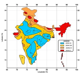
Fig. Seismic Zones of India
Pre-disaster and post earthquake preparedness
1. Observation and measuring of Earthquake
- National Centre for Seismology under Ministry of Earth Sciences is the nodal agency of Government of India (GoI), for monitoring earthquakes in and around the country.
- For this purpose, NCS maintains a National Seismological Network (NSN) consisting of 115 observatories spread across the country.
- The network is responsible for quick dissemination of information regarding earthquakes in least possible time apart from doing seismic micro-zonation of country’s cities with population of 5 Lakh and above.
2. Awareness Campaign
- National Disaster Management Authority (NDMA) of India is engaged with conducting regular awareness campaigns every year through print, electronic as well as social media from time to time to sensitize programs on prevention and preparedness for building safety from earthquakes.
3. Earthquake resilient infrastructure
- Seismic Micro-zonation of cities is done in order to provide information to urban planners about types of buildings to be constructed so that these can effectively resist shock waves.
- It generates inputs for constructing earthquake risk resilient buildings / structures to reduce and mitigate the impacts of earthquake shaking and for minimizing the damages to structures and loss of lives for safer urban planning.
- Further, Government of India is poised to follow guidelines by the Bureau of Indian Standards (BIS), Building Materials & Technology Promotion Council (BMTPC) and Housing and Urban Development Corporation (HUDCO) etc. for design and construction of earthquake risk resistant structures to minimize the loss of life and damage to property caused by earthquakes.
|
Case Study: Bhuj Model of rehabilitation
- A massive earthquake measuring 7.9 on the Richter Scale struck Kutch district of western Gujarat in 2001 leading to loss of lives and property. Over 37.8 million people were affected.
- In post disaster rehabilitation, the government took in rebuilding the State on sustainable disaster-resistant foundations.
- The Gujarat model of rehabilitation started with an aim to “build back better” with “owner-driven reconstruction” to achieve the long-term goal of sustainable disaster-resilient development.
- Gujarat became the first state in India to enact the Gujarat State Disaster Management Act 2003.
- The Act clarifies the roles of principal stakeholders in disaster management. The act became the blueprint for India’s Disaster Management Act, 2005.
- Immediate actions
- Within days of the earthquake, temporary health centres were set up in tents and a public health lab was established in a pre-fabricated structure in Bhuj to ensure continuity of health services and disease surveillance.
- This was rapidly followed by GIS-based disease surveillance as an early warning mechanism to prevent outbreaks.
- Long term actions
- The State Government rebuilt government infrastructures using the Base Isolation Technique which is essentially a structural technique that makes buildings earthquake-resilient.
- State government promoted such infrastructures to be built by private individuals.
|
B. Cyclones and Tsunamis
Introduction
- Out of 7516 Km of Indian coasts line 5770 Km (76.76%) are highly vulnerable to natural hazards such as Cyclones and Tsunami.
- Most of the cyclones generated in the South Asia are from Bay of Bengal and Indian Ocean. Indian region inhabits 7 % of the total tropical cyclones of the world.
- In India, cyclones are classified by:
- Strength of associated winds,
- Storm surges
- Exceptional rainfall occurrences.
- More cyclones occur in the Bay of Bengal than the Arabian Sea and the ratio is approximately 4:1.
India’s vulnerability to Tsunamis
- Some of the studies have suggested that Indian Ocean Region in general and India’s West Coast in Particular is vulnerable to Tsunamis.
- The Makran subduction zone can have magnitude 9 earthquake and consequent high tsunami wave.
- These waves can have larger impacts on India’s West Coast which is signified by India’s economic prosperous regions and houses nuclear plants.
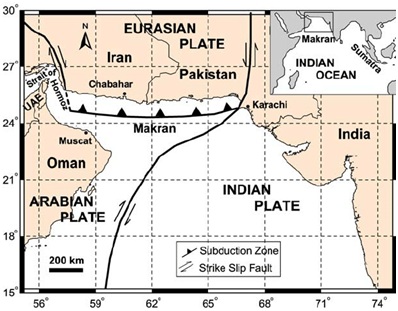
Fig: The Makran Subduction Zone
Wind and Cyclone Zones in India
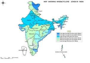
Fig. Cyclone Zones in India
Pre and post disaster preparedness of cyclones and Tsunamis in India
- Cyclone Warning System
- Cyclone warning system with last mile connectivity helps in evacuation of people from coastal regions before the landfall of cyclone thus minimizes the loss of lives and property.
- Green Belts
- Green Belts along the coastal region helps in decreasing intensity of Tsunamis and cyclones. The green belt includes planting of trees such as palm trees, mangroves e.t.c.
- Further, the roots of trees along the coastline also helps in reducing the intrusion of saline water in water table.
- Coral Conservation
- Coral reefs serve as an effective first line of defense to incoming waves, storms and rising seas.
- According to a new study cited by USGS, Coral reefs reduce the wave energy of Tsunamis and cyclone induced waves that would otherwise impact coastlines by 97 percent.
- The restoration and conservation of coral reefs is an important and cost effective solution to reduce risks from coastal hazards and climate change.
- Cyclone Shelters
- India follows a strategy of having Multi-Purpose Cyclone Shelters along the coastline for tropical cyclone risk mitigation.
- These shelters are meant to provide refuge to vulnerable populations at the time of a cyclonic storm and otherwise to be used as school, community centres etc.
- Community Participations
- Communities living along the coastlines are more aware of the local conditions and hence their participation in disaster management speeds up the process of disaster management and rehabilitation.
|
Case Study: Odisha Model of Cyclone mitigation
- In October 1999, a super cyclone of massive proportions ripped through the entire Odisha coast snuffing away over 10,000 lives while rendering millions homeless.
- This led to a massive planning by Odisha government post disaster leading to recognition of ‘Odisha Model’ by many international institutions.
- Cyclone mitigation infrastructures: It built a large number of multi-purpose cyclone shelters under National Cyclone Risk Mitigation Project and built an Early Warning Dissemination System (EWDS) with last-mile connectivity.
- 1,205 villages from 22 blocks in the coastal districts of Balasore, Bhadrak, Jagatsinghpur, Puri and Ganjam have been covered under the EWDS.
- Currently, Odisha has a network of over 870 cyclone and flood shelters that can house 1000 people each.
- The state has raised 20 units of Odisha Disaster Rapid Action Force (ODRAF) that comprises highly trained personnel with multi-disaster tackling capabilities.
- Pucca Housing along coastal regions: the state government has converted a large number ‘Kuchha houses’ to pucca ones in coastal region under state-specific schemes like Biju Pucca Ghar Yojana, Mo Kudia or central schemes like Pradhan Mantri Grameen Awas Yojana.
- Decentralized disaster management: Odisha has also built disaster-specific institutional mechanism and currently has 16 district-level disaster management planning committees covering 155 block-level disaster management planning committees and 22,000 village-level disaster management committees.
- Community Participation: Odisha government started community level planning by engaging local communities in coastal region by education and awareness programmes.
|
C. Land Slides
- Over 12% of India’s landmass is prone to landslides. The major landslide prone areas in India include the Western Ghats and Konkan Hills (Tamil Nadu, Kerala, Karnataka, Goa and Maharashtra), Eastern Ghats (Araku region in Andhra Pradesh), North-East Himalayas (Darjeeling and Sikkim) and North West Himalayas (Uttarakhand, Himachal Pradesh, Jammu and Kashmir).
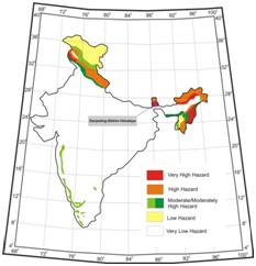
Fig. Landslides Prone Zones in India
Pre-disaster and Post Disaster Management of Landslides
- Hazard mapping
- Hazard mapping locates areas prone to slope failures. This helps to avoid building settlements in such areas. These maps will also serve as a tool for mitigation planning.
- Afforestation
- Areas covered by degraded natural vegetation in upper slopes should be afforested with suitable species. The roots of trees often binds the soil particle and prevents landslides.
- Planned Infrastructure Development
- Any developmental activity initiated in the area should be taken up only after a detailed study of the region has been carried out.
- In construction of roads, irrigation canals etc. proper care is to be taken to avoid blockage of natural drainage
- Relocation of settlements and infrastructure should be done in case of their location in sites of landslides.
- Retaining Walls
- Retaining Walls can be built in order to check land from slipping. However, these are walls are able to prevent only those landslides which are lighter or less severe.
|
Case Study: Char Dham Yatra Project
- As Himalayan ranges are still in process of uplifting, Uttrakhand’s mountain ranges of Kumaon and Garhwal Himalayas are still in process of formation.
- The all-weather Char Dham Yatra Project which connects four pilgrimage sites of the state has been devastated with landslides.
|
D. Forest Fires
- 40% of forests in India are exposed to occasional fires, 7.49% to moderately frequent fires and 2.405 to high incidence levels while 35.71% of India’s forests have not yet been exposed to fires of any real significance.
- According to the State of Forests Report, 2021, last year India reported 2.7 times more than the fires reported between November 2019 and June 2020.
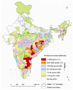
Fig. Forest Fire in India
Pre and Post-Disaster management in case of forest fires in India
1. Early Warning System
- Satellite based remote sensing technology and GIS tools have been effective in better prevention and management of fires through creation of early warning for fire prone areas.
- It also helps in monitoring fires on real time basis and estimation of burnt scars.
2. Fire Lines
- Fire lines are wide clearings, ranging from 20 to 300 m, made in a forest to stop the spread of fire. These are also called firebreak or double track, fuel break, fireroad and firetrail in Australia.
- These clearings are often maintained in order to keep them free from small shrubs and wild grasses so that fire can be contained within the limits of the forest.
E. . Floods
- India faces some of the highest disaster risk levels in the world, ranked 29 out of 191 countries by the 2019 Inform Risk Index.
- India has very high exposure to flooding, including, riverine, flash, and coastal, as well as high exposure to tropical cyclones and their associated hazards and drought.
- According to National Disaster Management Authority, out of the total geographical area of 329 million hectares (mha), more than 40 mha is flood prone.
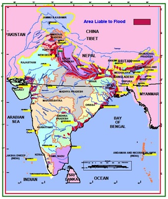
Fig: India’s Flood Prone Regions
- Droughts
- As high as 68 percent of the cropped area in India is vulnerable to droughts of which 33 percent is classified as 'chronically drought-prone' comprising desert and semiarid regions that receive less than 750 mm mean annual rainfall.
- In India, droughts have been classified into four types. These are:
- Meteorological droughts occur when there are long gaps in normal rainfall and are measured based on the degree of dryness and the duration of the dry period.
- Agricultural droughts occur when there is insufficient soil moisture to meet the needs of a crop at a particular time. Agricultural drought usually follows meteorological drought and occurs before a hydrological drought. Agricultural drought can be measured through indicators such as lack of rainfall, changes in evapotranspiration, soil water deficits, reduced groundwater or reservoir levels etc.
- Hydrological droughtsare the result of surface and subsurface water supplies from streams, rivers and lakes becoming scarce due to scanty rainfall. The frequency and severity of hydrological droughts are defined at the watershed or river basin scale and are influenced by factors such as land degradation or land use changes, construction of dams etc.
- Socioeconomic droughts occur when water shortage starts to affect people’s lives, individually and collectively.
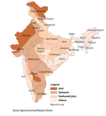
Fig. India’s Drought Prone Regions
Conclusion
- Due to its geographical extent, India must opt for regional and tailor made solutions for disaster mitigation with locally available resources and community participation.
- The climate change has adversely impacted India in many ways as it has increased the frequency of natural disasters such as forest fires, floods and droughts coupled with salinization of water table and submergence in coastal regions, intensification of cyclones e.t.c.
- Hence, India must strengthen its disaster management framework to counter such adversities in future.