Shapes of Political Boundaries
- Categories
International Relations: Growth & Connectivity
- Published
13th Dec, 2022
-
Introduction:
- Seventy-five years after India won Independence on 15 August 1947, the country’s internal boundaries continue to change, with the creation of two newly formed Union territories (UTs) by bifurcating the state of Jammu and Kashmir.
- India’s internal boundaries have undergone continuous evolution over the past seven decades.
How did it all start?
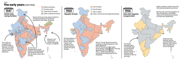
- On the “appointed day”, as Independence Day was referred to in the Indian Independence Act, of 1947, British paramountcy lapsed in India, leading to the formation of two independent dominions- India and Pakistan.
- Pre-independence India consisted of state units, provinces, and more than 550 scattered princely states.
- Nearly 114 of these, through the Instrument of Accession, had already joined India before August 15. The rest had the choice of joining either India or Pakistan, with most deciding to accede to the former.
- From then to now, as India has completed 75 years of independence and has 28 States and eight Union Territories, the internal boundaries of the country have undergone several changes with States being reorganized in multiple phases, with different factors behind the redrawing of the map.
Transition from dominion to the republic of states:
- By 26 January 1950, India had formally transitioned to a republic of states from a dominion. It had largely amalgamated the smaller states into larger regional territories, such as Saurashtra.
- This union of states had three classifications based on whether they were former provinces (part A), princely states (part B), and territories that were going to be directly ruled by the Union government (part C), the precursor to UTs.
- Following the creation of an Andhra state in 1953 for Telugu-speaking regions of Madras state, the State Reorganization Commission (SRC) was established to evaluate the restructuring of the republic largely along linguistic lines.
- However, that recommendation fell on deaf ears as they were split subsequently.
Changes in state Boundaries:
- The biggest reorganization of India’s internal boundaries occurred in 1956 when an official States Reorganization Act was implemented. But even after that, there were nine changes in state boundaries.
- Apart from the loss of territory to Pakistan in 1947 (parts of Kashmir, though they continue to be claimed by India and are part of India’s map) and to China in 1963, India’s external boundaries has changed only three times—when Goa was subsumed into the Indian Union in 1961, Pondicherry in 1962 (officially) and Sikkim in 1975.
- While most regions in British India achieved independence on 15 August 1947, several regions joined the Indian Union later. States, such as Kashmir, Hyderabad, Junagadh, Manipur, and Tripura, became part of the Union in the period between 1947 and 1949, not always without controversy.
Consolidation of the many princely states
- The Department, led by Sardar Vallabhbhai Patel and his Secretary V.P. Menon, took up the task of integrating the over 550 princely states into India. While a majority of the provinces and native Indian states had acceded to India before August 1947, the process of integrating the rest lasted till 1948.
Hyderabad:
- Hyderabad became part of India more than a year after the latter’s existence as an independent nation. Ruled by the hereditary ruler Nizam Mir Osman Ali Khan, the kingdom fancied its chance as an independent country. Its eventual surrender in September 1948 was a result of ‘Operation Polo,’ where Indian troops entered the erstwhile princely state.
Operation Polo was the code name of the Hyderabad "police action" in September 1948, by the then newly independent Dominion of India against Hyderabad State.
Junagarh:
- Another princely state, Junagadh, had decided to cede to Pakistan, with Pakistan accepting its request. However, protests broke out in the aftermath of this decision, forcing Junagadh’s Dewan to flee to Karachi. The Dewan requested the Indian government restore order and troops entered Junagadh in early 1948. A referendum was held in February of that year, in which an overwhelming majority of its population voted to integrate with India.
Kashmir:
- Kashmir for months contemplated whether to join India or Pakistan, but facing pressure and military action from the latter, Kashmir’s Raja Hari Singh asked India for help and later signed the Instrument of Accession on October 26, 1947.
|
As per the First Schedule of the Constitution in 1949, integrated territories were grouped into 27 States, divided into Part A, B, C, and D categories:
- Part A states were erstwhile Governors’ provinces
- Part B was former Princely States or clusters of Princely States
- Part C was states run by commissioners appointed by the President
- Part D comprised solely of the Andaman and Nicobar Islands, then run by a Centre-appointed Lieutenant Governor.
|
Reorganization on a linguistic basis
- Nationalism and the struggle for an independent India already had started to develop regional linguistic undercurrents in the early 20th century.
- The multiple bifurcations of the Bengal presidency in the early 1900s to form Bihar and Orissa provinces are cases in point.
- The 1920 Nagpur session of Congress also accepted the idea of linguistic provinces.
- As the grouping of states in 1950 was done based on forms of governance, calls for redrawing the map on a linguistic basis grew stronger.
- In 1948, the government appointed the S.K. Dhar commission on linguistic provinces, which recommended that until nationalistic feelings strengthened in the country, States should function solely as administrative units under the Centre.
- Following this, the JVP committee headed by former Prime Minister Jawaharlal Nehru, Mr. Patel, and Pattabhi Sitaramayya was formed but their report too rejected linguistic reorganization.
|
First linguistic state
- The government eventually yielded and created the first linguistic state — Andhra Pradesh for Telugu-speaking people— in 1953, carving it out of the Madras after Potti Sriramulu fasted to the death protesting for the creation of the State.
- Later the States Reorganization Commission (SRC) submitted its report in 1955 suggesting the creation of 16 states and three Union Territories. The government instead created 14 States and six Union Territories under the State’s Reorganisation Act passed in 1956.
- States- Assam, Bihar, Bombay, Jammu and Kashmir, Kerala, Madhya Pradesh, Madras (renamed Tamil Nadu in 1969), Mysore (renamed as Karnataka in 1973), Orissa, Punjab, Rajasthan, Uttar Pradesh, and West Bengal.
- Union Territories- Manipur, Tripura, Andaman and Nicobar Islands, Delhi, Himachal Pradesh, Laccadive, Minicoy, and Amindivi Islands.
The developments continued:
- The Samyukta Maharashtra Andolan and Mahagujarat Andolan protests led to the split of the Bombay state in 1960 into two parts: Maharashtra and Gujarat.
- The Punjabi Suba movement, led by the Akali Dal, gained momentum in phases and finally, in 1966, led to the carving out of Punjab for Sikhs and Punjabi-speakers, Haryana for Hindi speakers, with the hilly areas of Punjab becoming Himachal Pradesh.
- In late 1961, Indian troops captured Goa and Daman, and Diu, making the regions a part of India. Goa was given statehood in 1987 and D&D became a Union Territory.
- With the States Reorganization Act of 1956, only the State of Assam was created in the North-East, while the long-standing demands of Nagas and Mizos for separate States were not accepted.
- After Assam, Nagaland was the first to get statehood for the Naga people in 1963.
- Meghalaya then became a state in 1972, with a majority of the population belonging to the Garo and Khasi ethnic groups.
- Then the Union Territories of Manipur and Tripura were granted statehood in the same year.
- Arunachal Pradesh, of strategic importance to India due to its border with China, was first made a Union Territory by the government’s initiative in 1972 and then granted statehood in 1982.
- Sikkim remained India’s protectorate till 1975 when it was merged with India to become a State and the institution of the king was dismantled.
- At the turn of the millennium in 2000, three states- Jharkhand, Chhattisgarh, and Uttarakhand were carved out of Bihar, Madhya Pradesh, and Uttar Pradesh, respectively.
- The State of Telnagana was eventually formed out of Andhra Pradesh in 2014 with Hyderabad as the common capital for 10 years.
- The most recent redrawing of the map took place in 2019 with the revocation of Jammu and Kashmir’s special status and the creation of the Union Territories of J&K and Ladakh
Boundary dispute with Pakistan:
- Pakistan is in illegal and forcible occupation of approximately 78,000 sq. km of Indian Territory in Jammu and Kashmir.
- In addition, under the so-called Sino-Pakistan Boundary Agreement of 1963, Pakistan illegally ceded 5,180 sq. km in Pakistan Occupied Kashmir to China.
- The International Boundary in the Sir Creek area and the International Maritime Boundary line (IMBL) between India and Pakistan have not been demarcated.
Timeline of Border dispute with Pakistan:
- Pakistan launched attacks on India in 1948, 1965, 1971, and 1999.
- Pakistan also supported insurgency and terrorism in the State of Jammu & Kashmir and also aids and abets cross-border terrorism targeted against India.
- It endangers the security and stability not only of India but of the entire region.
- Pakistan covets the territory of J&K which is an integral part of India
Steps taken to establish Peace:
- India seeks normalization of relations with Pakistan and is ready to resolve all outstanding issues including J&K with Pakistan through peaceful bilateral dialogue in the spirit of the Shimla Agreement (1972) & Lahore Declaration (1999).
- However, to have a meaningful dialogue an environment free from terror and violence is necessary.
Boundary dispute with Bangladesh:
- During the visit of our Prime Minister to Bangladesh in June 2015 the Land Boundary Agreement between India and Bangladesh of 1974 and its Protocol of 2011 were ratified. The implementation of the Agreement and Protocol has settled all outstanding land boundary issues between India and Bangladesh. The award rendered by the Arbitration Tribunal for Delimitation of Maritime Boundary between India and Bangladesh on July 7, 2014, has settled the maritime boundary between India and Bangladesh.
Boundary dispute with China:
- Indian territory under the occupation of China in Jammu & Kashmir is approximately 38,000 sq. kms. In addition, under the so-called China-Pakistan “Boundary Agreement” signed between China and Pakistan on 2 March 1963, Pakistan illegally ceded 5,180 sq. kms. of Indian territory in Pakistan Occupied Kashmir to China.
- The two sides have agreed to each appoint a Special Representative (SR) to explore the framework for a boundary settlement from the political perspective of the overall bilateral relationship.
- The 19th round of Special Representatives Talks on the India-China boundary question was held in Beijing from 20-21 April 2016. India and China are committed to resolving bilateral issues through dialogue and peaceful negotiations and in a fair, reasonable, and mutually acceptable manner
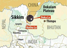
Doklam Standoff:
- Doklam is also known as Donglong area of the Sikkim sector. China was constructing a motorable road from Dokola toward the Bhutan army camp. It affects the boundary between the two countries. Bhutan asked Beijing to restore the status quo by stopping the work. Donglong is a tri-junction area near the Chumbi Valley.
- It is under China’s control; however, Bhutan claims sovereignty over the area.
- Both have written agreements between 1988 and 1998, stating that the two sides agree to maintain tranquility in their border areas pending a final settlement on the boundary question.
- It was also decided to maintain the status quo on the boundary as before March 1959.
- Despite several rounds of engagement between China and Bhutan, the dispute between the two over Doklam has not been resolved.
- It flared up in 2017 when the Chinese were trying to construct a road in the area, and Indian troops, in aid of their Bhutanese counterparts, objected to it, resulting in the stand-off. Doklam is strategically located close to the Siliguri Corridor, which connects mainland India with its northeastern region. The corridor, also called Chicken’s Neck, is a vulnerable point for India.
- Despite several rounds of negotiations between Special Representatives, the dispute is nowhere near a solution.
|
Line of Actual Control
- The disputed boundary between India and China, also known as the Line of Actual Control (LAC), is divided into three sectors: western, middle, and eastern.
- The LAC mostly passes on the land, but Pangong Tso is a unique case where it passes through the water as well.
- The points in the water at which the Indian claim ends and the Chinese claim begins are not agreed upon mutually.
|
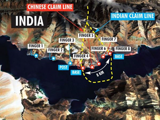
The Pangong Tso lake and Finger 5
- Pangong Tso lake in eastern Ladakh has often been in the news, most famously during the Doklam standoff.
- Fingers in the lake:
- The barren mountains on the lake’s northern bank called the Chang Chenmo, jut forward in major spurs, which the Army calls “fingers”.
- India claims that the LAC is coterminous with Finger 8, but it physically controls area only up to Finger 4.
- Chinese border posts are at Finger 8, while it believes that the LAC passes through Finger 2.
- The quarrel between Indian and Chinese soldiers took place in this general area at Finger 5, which led to a “disengagement” between the two sides.