

Published: 28th Jan, 2024
How the weather department uses satellites to track North India’s fog
Context
TheKalpana 1 and INSATs 3A, 3D, and 3DR satellites have bolstered India’s weather monitoring and warning services
I. Extended Period of Heavy Fog Across North India
- Heavy fogs in North India:Since December 2023, regions including Bihar, Uttar Pradesh, Uttarakhand, Haryana, Delhi, and Punjab in North India have been grappling with heavy fog.
- IMD warnings: The India Meteorological Department (IMD) warned of "very dense fog" in several states, impacting visibility to less than 50 meters in some areas.
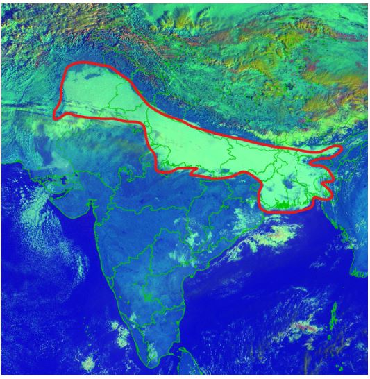
A satellite image the IMD shared on January 16, 2024, showing the fog (outlined in red) blanketing North India at 8.30 am on the same day.
II. Insights from INSAT 3D Satellite Maps
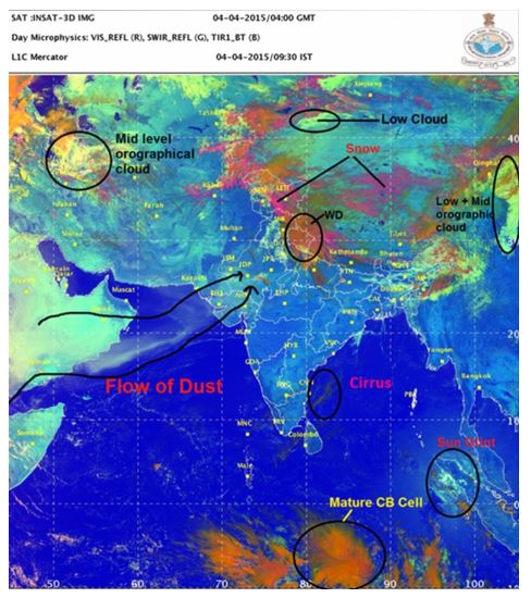
- Fog Patterns:IMD has been using INSAT 3D and INSAT 3DR satellite maps to provide real-time alerts on fog patterns.
- RGB imaging:The satellite maps, utilize RGB imaging based on solar reflectance and brightness temperature.
Condition for fog formations:
|
III. Solar Reflectance and Brightness Temperature: Key Factors
- Solar reflectance:It is a measure of solar energy reflected by a surface compared to the incident solar energy.
- Brightness temperature:It is linked to an object's temperature and thermal radiation, contributes to the coloration of the images.

IV. INSAT 3D's 'Day Microphysics' and 'Night Microphysics' Data
- RGB colorscheme:'Day Microphysics' assesses solar reflectance at three wavelengths (0.5 µm, 1.6 µm, and 10.8 µm) to determine the RGB color scheme.
- Cloud type analysis:'Night Microphysics' relies on the difference between two thermal infrared signals to assign colors, aiding in cloud type analysis.
Analysis of Satellite Data:
- The detailed coloration derived from INSAT 3D and INSAT 3DR satellite maps enables the identification of various cloud types, initial stages of convection, thunderstorm maturation, snow areas, and fire detection.
- The technology also facilitates tracking moisture droplets, temperature variations, and aids in the prediction of weather events such as cyclones.
- The integration of AI and satellite data, as showcased in this fog monitoring scenario, underscores the critical role technology plays in understanding and responding to complex climate phenomena.
V. Future Prospects with INSAT 3DS Satellite
- Meteorological satellite: In 2024, the Indian Space Research Organisation (ISRO) plans to launch the INSAT 3DS meteorological satellite.
- Enhanced technology:INSAT 3DS, the successor to INSAT 3DR, is expected to further enhance spatial resolution, spectral channels, and overall functionality for advanced weather monitoring.
Way Forward:
- The continuous monitoring of North India's fog through advanced satellite technology not only highlights the current weather challenges but also emphasizes the need for ongoing advancements in satellite capabilities.
- The imminent launch of INSAT 3DS marks another stride in India's commitment to cutting-edge meteorological observation and weather prediction.