

11th September 2025 (16 Topics)
1
Sep
2
Sep
3
Sep
4
Sep
5
Sep
6
Sep
8
Sep
9
Sep
10
Sep
11
Sep
12
Sep
13
Sep
15
Sep
16
Sep
17
Sep
18
Sep
19
Sep
20
Sep
22
Sep
23
Sep
24
Sep
25
Sep
26
Sep
27
Sep
29
Sep
30
Sep
Geotagging in Census 2027
Context:
India’s 2027 Census will be conducted digitally for the first time, with geotagging of all buildings to ensure accuracy in enumeration.
Geotagging in Census 2027
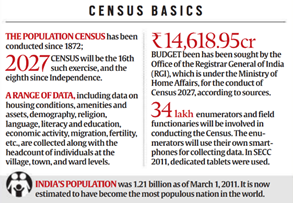
- The Census of India, conducted every ten years since 1872, is the most extensive source of demographic, social, and economic data. The 2027 Census will be the 16th Census and the 8th since Independence.
- For the first time, it will be conducted digitally with options for self-enumeration.
- Geotagging refers to marking latitude-longitude coordinates of buildings on a Geographic Information System (GIS) map. This ensures a unique, precise spatial identity for every building.
- During the Houselisting Operations (HLO) phase (April–September 2026), enumerators will geotag buildings using Digital Layout Mapping (DLM).
- A Census House is defined as a building or part of it, recognized as a separate unit due to a distinct entrance. The 2011 Census recorded 84 million houses (306.16 million occupied, 24.67 million vacant).
- 34 lakh enumerators will be deployed using smartphones for data collection; the budget sought for Census 2027 is ?14,618.95 crore.
- Data collected will include number of Census Houses, classification of buildings (residential, non-residential, partly residential, landmark), and households residing in them.
- Geotagging will reduce workload by providing accurate enumeration, workload management, and monitoring of field functionaries.
- Earlier censuses relied on manual sketches; now GIS will replace them.
- Similar geotagging practices are already used in schemes like Pradhan Mantri Awaas Yojana-Gramin (PMAY-G).
More Articles