
Context
Kashmir’s highly fertile alluvial soil deposits called ‘karewas’ are being destroyed in the name of development.
About
About Karewa:
- In the Kashmiri dialect, the term Karewa means “elevated table land”.
- Firstly, this term was used by Godwin Austin in 1859 and later on by Lydekker in 1878 for unconsolidated to semi-consolidated sand clay conglomerate sequence.
- “Vudr” is the local name for Karewas in Kashmiri language.
- Karewas are the thick deposits of glacial clay and other materials embedded with moraines.
- These are unconsolidated lacustrine deposits. Lacustrine means “associated to lakes”.
- Kashmir valley resides between the Great Himalayas and the Pir Panjal ranges of the Kashmir Himalayas.
- In earlier times, when the upliftment of the Pir Panjal ranges happened, the flow of the river has stopped.
- As a result, the whole of Kashmir valley became a large lake. Slowly, the glacial deposits have accumulated here in this lake.
- Thus creating a large lacustrine plain.
- Later on, the water drained away and these unconsolidated deposits remained there.
- These unconsolidated gravel and mud deposits are known as Karewa formation.
- However, some beliefs also say that the water accumulation was of Tethys Sea and over time, many earthquakes came.
- As a result, some fault developed in the Baramulla range and the water drained out.
- The depth of Karewa deposits is about 1400 m and most of the area lies to the west of the river Jhelum.
Significance:
- The fertility of these patches is believed to be the result of their long history of formation.
- When formed during the Pleistocene period (2.6 million years to 11,700 years ago), the Pir Panjal range blocked the natural drainage in the region and formed a lake spanning 5,000 sq km (roughly three times the size of Delhi).
- Karewa, these plateaus are 13,000-18,000 metre-thick deposits of alluvial soil and sediments like sandstone and mudstone.
- This makes them ideal for cultivation of saffron, almonds, apples and several other cash crops.
- Kashmir saffron, which received a Geographical Indication (GI) tag in 2020 for its longer and thicker stigmas, deep-red colour, high aroma and bitter flavour, is grown on these karewas.
Destruction of Karewas:
- Despite its agricultural and archaeological importance, karewas are now being excavated to be used in construction.
- Between 1995 and 2005, massive portions of karewas in Pulwama, Budgam and Baramulla districts were razed to the ground for clay for the 125-km-long Qazigund-Baramulla rail line.
- The Srinagar airport is built on the Damodar karewa in Budgam.
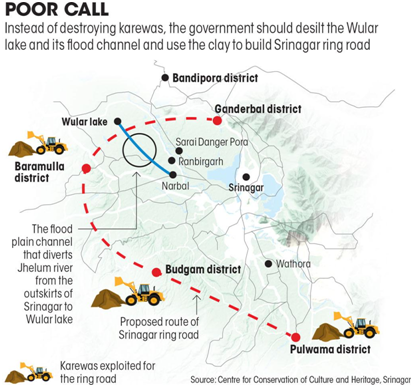
- The most recent violation is in 2021 when the Baramulla deputy commissioner gave consent for the excavation of karewas around Pattan village and uses the clay for the construction of the Srinagar ring road.
- Two other karewas—in Pulwama and Budgam districts—are also being excavated for the 58-km-long project.

Acts violated:
- The Jammu and Kashmir Land Revenue Act, 1996, says the topographic shape of a karewa or hill cannot be changed in the valley.
- But clay mining often razes the highland to the ground and changes the entire topography of the place.
- The residents allege that the project also violates the Jammu and Kashmir Minor Mineral (Storage, Transportation of Minerals and Prevention of Illegal Mining) Rules, 2016.
- “The panchayat needs to give consent for minor mineral mining. The order has conveniently bypassed this.”


