

8th February 2023 (7 Topics)
1
Feb
2
Feb
3
Feb
4
Feb
6
Feb
7
Feb
8
Feb
9
Feb
10
Feb
11
Feb
13
Feb
14
Feb
15
Feb
16
Feb
17
Feb
18
Feb
20
Feb
21
Feb
22
Feb
23
Feb
24
Feb
25
Feb
27
Feb
28
Feb
NASA-ISRO partnership satellite ’NISAR ‘
Context
Recently, the Joint project of the National Aeronautics and Space Administration (NASA) and the Indian Space Research Organisation (ISRO), called NISAR, got a send-off ceremony at the American space agency’s Jet Propulsion Laboratory (JPL) in Southern California.
Background
- NISAR has been built by space agencies of the US and India under a partnership agreement signed in 2014.
- NISAR is expected to be launched in January 2024 from Satish Dhawan Space Centre into a near-polar orbit.
- The satellite will operate for a minimum of three years.
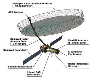
About NISAR:
- NISAR stands for NASA-ISRO Synthetic Aperture Radar.
- It is an Earth observation satellite
- The 2,800 kilograms satellite consists of both L-band and S-band synthetic aperture radar (SAR) instruments, which makes it a dual-frequency imaging radar satellite.
- NASA has provided the L-band radar, GPS, a high-capacity solid-state recorder to store data, and a payload data subsystem.
- And the ISRO has provided the S-band radar, the GSLV launch system and spacecraft.
- Another important component of the satellite is its large 39-foot stationary antenna reflector
- It is made of a gold-plated wire mesh, the reflector will be used to focus the radar signals emitted and received by the upward-facing feed on the instrument structure.
Additional features:
- By using (SAR), NISAR will produce high-resolution images.
- SAR is capable of penetrating clouds and can collect data day and night regardless of the weather conditions.
|
According to NASA, “the instrument’s imaging swath — the width of the strip of data collected along the length of the orbit track — is greater than 150 miles (240 kilometres), which allows it to image the entire Earth in 12 days. |
What is the mission?
- NISAR will observe subtle changes in Earth’s surfaces, helping researchers better understand the causes and consequences of such phenomena.
- It will spot warning signs of natural disasters, such as volcanic eruptions, earthquakes and landslides.
- The satellite will also;
- Measure groundwater levels,
- Track flow rates of glaciers and ice sheets, and
- Monitor the planet’s forest and agricultural regions, which can improve our understanding of carbon exchange.
- ISRO will use NISAR for a variety of purposes including agricultural mapping, and monitoring of glaciers in the Himalayas, landslide-prone areas and changes in the coastline.
More Articles