
7th August 2024 (8 Topics)
Context
Recently, over 360 people have died and more than 200 have been injured so far due to the catastrophic landslides in Wayanad, Kerala. Such deadly landslides are being reported from the Himalayas to the Deccan Plateau increasingly.
What are Landslides and how do they occur?
- Landslides are the movement of rock, earth, or debris down a slope. They can vary in size and type, but all involve the force of gravity acting on weakened materials that make up the slope.
- Landslides can be categorized into various types, including rock falls, slides, flows, and topples, each defined by the material involved and the manner of movement.
- Landslides often occur due to natural factors such as heavy rainfall, snowmelt, volcanic activity, earthquakes, and erosion. These factors can weaken the slope material or increase the downward force on the slope.
- Human activities like deforestation, construction, mining, and poor land management can destabilize slopes, making them more susceptible to landslides.
Reasons for increasing events of landslides:
- Altitude: High altitude is the most important factor in the occurrence of landslides, be it the Himalayan region or southern India.
- For example, even in Wayanad, tourism, human activities and construction in areas with a height of at least 2,000 metres have become factors for increasing landslides.
- Apart from this, extreme weather events are also playing a big role.
- Soil profile: The soil in the Himalayan region is made up of sedimentary rock and is loose. The soil of the Deccan Plateau is made of lava and magma, which is also loose.
- Rock system: The parent rock of the Deccan Plateau is much more solid compared to the Himalayas
- If there is height and lack of vegetation and the soil is loose, it creates a scenario for landslides at both places.
How we can control landslides?
- Improving surface and subsurface drainage: Because water is a main factor in landslides, improving surface and subsurface drainage at the site can increase the stability of a landslide-prone slope. Surface water should be diverted away from the landslide-prone region by channeling water in a lined drainage ditch or sewer pipe to the base of the slope. The water should be diverted in such a way as to avoid triggering a landslide adjacent to the site. Surface water should not be allowed to pond on the landslide-prone slope.
- Ground water can be drained from the soil using trenches filled with gravel and perforated pipes or pumped water wells.
- Excavating the head: Removing the soil and rock at the head of the landslide decreases the driving pressure and can slow or stop a landslide. Additional soil and rock above the landslide will need to be removed to prevent a new landslide from forming upslope. Flattening the slope angle at the top of the hill can help stabilize landslide-prone slopes.
- Buttressing the toe: If the toe of the landslide is at the base of the slope, fill can be placed over the toe and along the base of the slope. The fill increases the resisting forces along the failure surface in the toe area. This, in turn, blocks the material in the head from moving toward the toe. However, if the toe is higher on the slope, adding fill would overload the soil and rock below the toe, thus causing a landslide to form downslope of the fill.
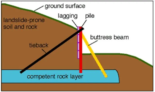
- Constructing piles and retaining walls: Piles are metal beams that are either driven into the soil or placed in drill holes. Properly placed piles should extend into a competent rock layer below the landslide. Wooden beams and telephone poles are not recommended for use as piles because they lack strength and can rot.

Early Warning System in India:
- LEWSs at the regional scale are used to assess the probability of landslide occurrence over a priori-defined warning zones, typically through forecasting and monitoring of meteorological variables, to give generalized warnings to communities and institutions working with hazard mitigation measures.
- Geological Survey of India (GSI), Ministry of Mines in collaboration with the British Geological Survey (BGS) under the National Environmental Research Council (NERC), UK funded, multi-consortium LANDSLIP project (www.landslip.org) has developed a prototype regional Landslide Early Warning System (LEWS) for India, and the same is currently being evaluated and tested by GSI in two pilot areas in India (Darjeeling district).
- GSI through the LANDSLIP project (www.landslip.org) is engaged in developing an experimental regional Landslide Early Warning System (LEWS) based on rainfall thresholds since 2017.
- The LANDSLIP research has developed a prototype model in 2020 based on the terrain-specific rainfall thresholds for two test areas (Darjeeling district, West Bengal, and the Nilgiris district, Tamil Nadu).
More Articles


