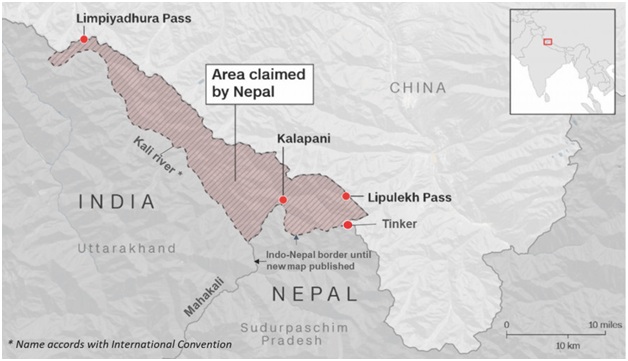

Context
Nepal signals to solve the territorial dispute over Kalapani through dialogue.
About
About Kalapani
- The Kalapani region gets its name from the Kali River.
- It is located on the eastern corner of Uttarakhand district of
- Share the northern border with the Tibetan Autonomous Region of China and Nepal east and south.
- It is wedged in between Limpiyadhura, Lipulekh and Kalapani.
- The area is a major regional dispute between Nepal and India covering at least 37,000 hectares of land in the High Himalayas.

Indo-Nepal border issues
- The Indo-Nepal border was originally delineated by the 1816 Sugauli Treaty.
- The treaty established the Kali River (Sharda, Mahakali)as a border, with the area east of the river going to Nepal.
- Nepal’s stand: Nepal's stance is that the river originates from a stream northwest of Lipulekh, which brings Kalapani, linpiyaxle, and lipulekh to its territory.
- India’s stand: India's stance is that the river originates in springs beneath Lipulekh, and hence this area falls within Pithoragarh district in the state of Uttarakhand, India.
Both sides have maps of the British period to claim their position.


