

18th August 2025 (15 Topics)
1
Aug
2
Aug
4
Aug
5
Aug
6
Aug
7
Aug
8
Aug
9
Aug
11
Aug
12
Aug
13
Aug
14
Aug
15
Aug
16
Aug
18
Aug
19
Aug
20
Aug
21
Aug
22
Aug
23
Aug
25
Aug
26
Aug
27
Aug
28
Aug
29
Aug
30
Aug
Cloudburst
Context:
Five children among seven killed in cloudburst, landslide in Kathua.
Cloudbursts in India: Causes, Consequences, and Preparedness
Definition and Characteristics
- Nature of Event: A cloudburst is a sudden and highly intense rainfall event (?100 mm/hour over 20–30 km²).
- Cloud Source: Typically originates in cumulonimbus clouds between 1000–2500 m altitude under unstable, moisture-rich conditions.
- Langmuir Effect: Raindrops grow through coalescence until gravitational pull overcomes updrafts, leading to a sudden downpour.
Climatological and Geophysical Mechanisms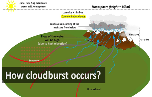
- Orographic Uplift: Moist air is forced upwards by hills, condensing rapidly into dense clouds.
- Airmass Convergence: Interaction of monsoon winds with dry air enhances vertical uplift.
- Instability and Low Pressure: Sudden temperature/pressure changes and regional depressions accelerate condensation.
- High Humidity and Lightning Delay: Excess moisture retention within clouds magnifies precipitation intensity.
Cloudburst-Prone Regions in India
- Himalayan States: Jammu & Kashmir, Himachal Pradesh, Uttarakhand, Sikkim.
- North-East India: Arunachal Pradesh, Meghalaya, Nagaland.
- Western Ghats: Kerala and Karnataka occasionally report such events.
Recent Examples
- Cloudburst-triggered Flash Flood in Chositi, Kishtwar (August 2025)
- Uttarkashi Flash Floods Following Cloudburst (5 August 2025)
- Mandi, Himachal Pradesh (July–August 2025)
- Himachal Pradesh (Kullu, August 2023)
- Uttarakhand (Rudraprayag, July 2023)
- Amarnath Yatra (J&K, July 2022)
- Ladakh (Leh, August 2010)
Hazards Associated with Cloudbursts
- Flash Floods: Torrents sweep away settlements, roads, and bridges in valleys.
- Landslides and Mudflows: Water-saturated slopes collapse, generating destructive slurry flows.
- Ground Subsidence: Excess pressure leads to sinkholes and hillside collapses.
- River System Impact: Riverbank erosion, course shifts, and temporary landslide lakes increase downstream flood risks.
Climate Change and Increasing Cloudburst Frequency
- Enhanced Atmospheric Moisture: Warmer air holds more water vapour, causing intense rainfall.
- Erratic Monsoon Patterns: Shorter, more intense rainfall episodes replace steady monsoon rains.
- Himalayan Vulnerability: Steep topography, fragile geology, and unplanned construction amplify disaster risks.
NDMA Guidelines on Cloudbursts
- Risk Mapping: GIS-based identification of hazard-prone zones.
- Radar Coverage Expansion: Installation of Doppler radars in vulnerable hill districts.
- Urban Drainage Planning: Design stormwater drains for short-duration high-intensity rainfall.
- Community Preparedness: Conduct mock drills, awareness campaigns, and early warning dissemination via SMS and sirens.
- Construction Regulation: Enforce slope-based building controls through micro-zoning techniques.
Way Forward
- Improved Prediction Systems: Adoption of high-resolution weather models and AI-based forecasting for localised rainfall.
- Strengthened Early Warning Mechanisms: Real-time monitoring networks in Himalayan States with siren/satellite-based alerts.
- Eco-sensitive Infrastructure: Restriction of construction in fragile slope zones, mandatory slope-stabilisation measures, and watershed management.
- Reforestation and Land Use Regulation: Afforestation to stabilise slopes and better land regulation to prevent unplanned expansion.
- Community Resilience: Training locals in evacuation, first aid, and relief operations to minimise casualties.
More Articles