

Published: 25th Jun, 2022
Context
Researchers have carried out a new study that includes an updated map of the earth’s tectonic plates.
- It sheds light on how past continents were formed by tectonic movements; new micro plates have been added with existing plates.
Background
- The plate models are used to evaluate risks from natural hazards whereas the province model can be used for further exploration of minerals and the orogeny model for a better understanding of the evolution of the earth.
- There is a need for re- mapping the tectonic plate boundaries to redefine the present day movements and plate behaviour.
- The last study regarding the maps where done in 2003.
What is plate tectonics?
- In plate tectonics the outermost part of the Earth – the crust and uppermost mantle – are viewed as acting as a single mechanical layer, the lithosphere.
- The lithosphere is divided into separate "plates" that move relative to each other on the underlying, relatively weak asthenosphere in a process ultimately driven by the continuous loss of heat from the Earth's interior.
- There are three main types of plate boundaries:
- Divergent, where plates move apart from each other and new lithosphere is formed in the process of sea-floor spreading;
- Transform, where plates slide past each other, and
- Convergent, where plates converge and lithosphere is "consumed" by the process of subduction.
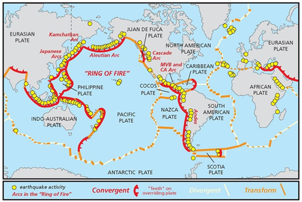
- This is a list of the 15 major tectonic plates:
- African Plate
- Antarctic Plate
- Arabian Plate
- Australian Plate
- Caribbean Plate
- Cocos Plate
- Eurasian Plate
- Indian Plate
- Juan de Fuca Plate
- Nazca Plate
- North American Plate
- Pacific Plate
- Philippine Plate
- Scotia Plate
- South American Plate
New Vs Old Model of Mapping
- The new model for tectonic plates better explains the spatial distribution of 90 per cent of earthquakes and 80 per cent of volcanoes from the past two million years whereas existing models only capture 65 per cent of earthquakes.
- The continents were assembled a few pieces at a time, a bit like a jigsaw.
- But each time the puzzle was finished, it was cut up and reorganised to produce a new picture. The study helps illuminate the various components so geologists can piece together the previous images.
- The researchers combined three models to map the new geological provinces and tectonic plates:
- A plate model based on the existing knowledge of tectonic plates
- A province model based on the geological information of the earth’s surface
- An orogeny model based on the process of mountain formation which is triggered when two tectonic plates collide.
- There are 26 orogenies (the process of mountain formation) that have left an imprint on the present-day architecture of the crust.
- Many of these are related to the formation of supercontinents.
- The new study added several new microplates to the existing tectonic plate model like the Macquarie microplate which sits south of Tasmania and the Capricorn microplate that separates the Indian and Australian plates.
- The biggest update to the existing plate model has been in western North America. The newly delineated boundary is much wider, approximately 1,500 km, than the previously drawn narrow zone.
- The other large change is in central Asia. The new model now includes all the deformation zones north of India as the plate bulldozes its way into Eurasia.
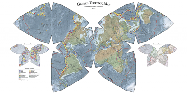
Fig. The New Mapping