

Published: 13th Jan, 2022
Introduction
- A Geographic Information System (GIS) is a system of computer software, hardware and data, personnel that make it possible to enter, manipulate, analyze, and present data, and the information that is tied to a location on the earth's surface.
- This system comprises of Software, Hardware, Data, and Personnel that make it possible to enter, manipulate, analyze and present information that is tied to a location on the earth's surface.
- There are different definitions for Geographic Information System, each developed from a different perspective or disciplinary origin. Some focus on the map connection, some stress the database or the software tool kit and others emphasis applications such as decision support.
- Defining a GIS can be done by either explaining what it can do (Functions) or by looking at the components.
- According to Environmental Systems Research Institute (ESRI)-A geographic information system (GIS) is a computer-based tool for mapping and analyzing things that exist and events that happen on earth.
- GIS technology integrates common database operations such as query and statistical analysis with the unique visualization and geographic analysis benefits offered by maps.
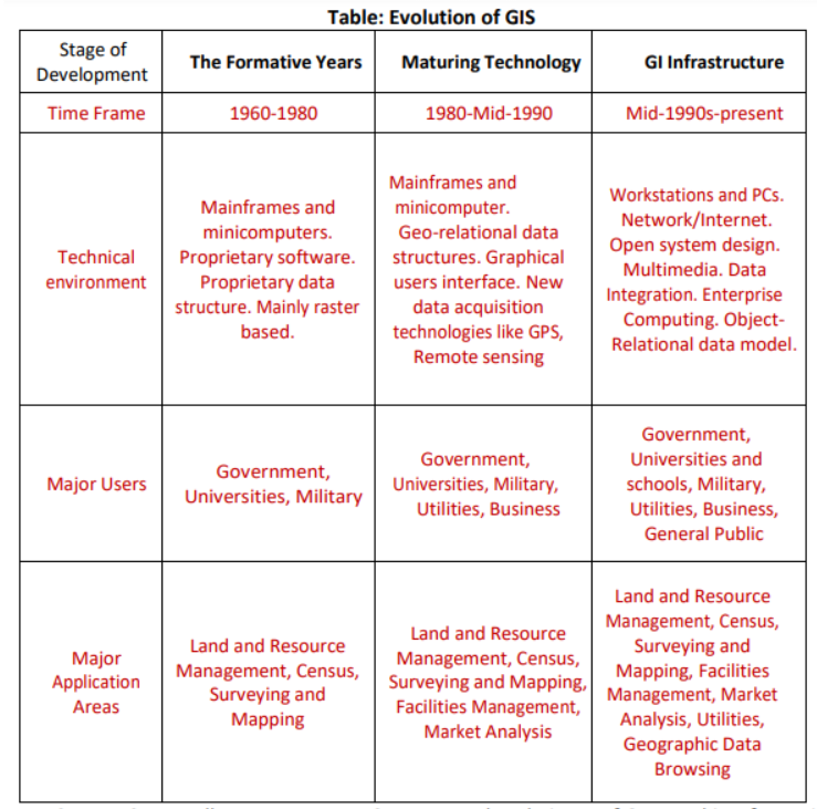
Advancements in GIS were the result of several technologies. Databases, computer mapping, remote sensing, programming, geography, mathematics, computer aided design, and computer science all played a key role in the development of GIS. We can group the history of GIS into several stages of development. Each stage in the history of GIS below:
➢ Paper Mapping Analysis with Cholera Clusters: The history of GIS all started in 1854. Cholera hit the city of London, England. British physician Dr. John Snow began mapping outbreak locations, roads, property boundaries and water lines. When he added these features to a map, something interesting happened: He saw that Cholera cases were commonly found along the water line. Dr. John Snow’s Cholera map was a major event connecting geography and public health safety. Not only was this the beginning of spatial analysis, it also marked the start of a whole field of study: Epidemiology – the study of the spread of disease. To this date, Dr. John Snow is known as the father of epidemiology. The work of John Snow demonstrated that GIS is a problem-solving tool. He put geographic layers on a paper map and made a life-saving discovery.
➢ Before 1960 (The GIS Dark Ages of GIS): Dark Ages GIS Computer mapping was in the dark. It was not developed. All mapping was done on paper or sieve mapping. The technology wasn’t here for GIS to come to light. In the 1950s, maps were simple. They had their place in vehicle routing, new development planning and locating points of interest. But none of this was done on computers. Imagine a world without computer mapping. With all the issues that came with paper maps, it was no surprise that cartographers and spatial users wanted to explore computing options for handling geographic data.
➢ 1960 to 1975 (Pioneering time of GIS): in the history of GIS, this was the main incentive to shift from paper to computer mapping. The early 1960 to 1980s was really the time period of GIS pioneering. The pieces were coming together with advancements in technology:
- Map graphics as outputs using line printers.
- Advances in data storage with mainframe computers.
- Recording coordinates as data input.
- These initial developments in the world of computing are what propelled GIS its next step forward. But what GIS really needed was a brilliant mind to put the puzzle pieces together. o
- Enter Roger Tomlinson – the father of GIS: It was during Roger Tomlinson’s tenure with the Canadian government in the 1960s when he initiated, planned and directed the development of the Canadian Geographic System (CGIS). This was a key time in the history of GIS because many consider CGIS as the roots of Geographic Information Systems. CGIS was unique because it adopted a layer approach system to map handling. Because of the vast amount of territory Canada occupies, the idea for a Canadian Land Inventory was developed in 1964. But it wasn’t until 1971 that it became fully operational. The Canadian Land Inventory used soil, drainage and climate characteristics to determine land capability for crop types and forested areas. It quickly recognized that accurate and relevant data was vital to land planning and decision-making. Over the years CGIS had been modified and improved to keep pace with technology
➢1975 to 1990 (Commercialization of GIS Software): As governments realized the advantages of digital mapping, this influenced the work of the Harvard Laboratory Computer Graphics. In the mid-1970s, Harvard Laboratory Computer Graphics developed the first vector GIS called ODYSSEY GIS. ESRI’s ARC/INFO used the technical framework from ODYSSEY GIS and this work led to the next stage of development in GIS – software commercialization. o In the late 1970s, memory size and graphics capabilities were improving. New computer cartography products included GIMMS (Geographic Information Making and Management Systems), MAPICS, SURFACE, GRID, IMGRID, GEOMAP and MAP. In the late 1980s, this segment of GIS history was marked with an increasing range of GIS software vendors.
➢ 1990 to 2010: (User Proliferation): Map Collaboration Users are starting to adopt GIS technology in different ways. Classrooms, businesses, governments around the world are starting to harness digital mapping and analysis. All the ingredients were ready for the infiltration of GIS to the people:
- Cheaper, faster and more powerful computers.
- Multiple software options and data availability.
- The launch of new satellites and integration of remote sensing technology.
- 1990 to 2010 was the period in the history of GIS when it really took off.
- But advancements in the technology have surpassed the average user. GIS users didn’t know how to take full advantage of GIS technology. Companies were hesitant to adopt GIS software. Countries didn’t have access to topographical data.
- But over time, these issues were laid to rest. Gradually, the importance of spatial analysis for decision-making was becoming recognized. Slowly, GIS was being introduced to classrooms and companies. Software was able to handle both vector and raster data. With more satellites being launched into orbit, this data collected from space could be consumed in a GIS.
➢ 2010 to Onward (The Open Source Explosion): Open Mapping With users getting accustomed to GIS software, this has sparked a new revelation in GIS – an open source explosion.
- Amazing projects like QGIS are providing any user with a computer with GIS software. Processors are now in gigahertz. Graphics cards are crisper than they’ve ever been before. We now think of GIS data storage in terabytes. It’s no longer megabytes.
- GIS data has become more ubiquitous. TIGER data, Landsat satellite imagery and even LiDAR data is accessible to download for free.
- Online repositories like ArcGIS Online store massive amounts of spatial data. It’s a matter of quality control and fitting it for your needs.
- But what stands out is the big shift of GIS users building their own GIS software in an open, collaborative way. This software is made available to the public and is called open source. The big plus is: they are for public use at no cost.
- Open source is becoming main stream today. We are gradually entering an era of open source GIS software. More light is shining on QGIS than ever before. Even though, there will always be a place for commercial GIS software. Software companies like Esri provide solutions to practically any spatial problem that exists today.
At a broad range of scales, map has become increasingly important as legal document that convey land ownership and jurisdictional boundaries, as tools to support decision making (For example, in urban planning). The GIS provides the ability to completely model utility networks, such as those supplying water, power and telecommunications to a large number of consumers. Such a system may operate at a variety of scales, modeling service Connections to consumers, service districts as well as detailed facilities inventories and layouts, such as transformers, valves conduits, and schematic diagrams. Applications of the GIS are listed below:
- Navigation (Routing and Scheduling): Web-based navigation maps encourage safe navigation in waterway. Ferry paths and shipping routes are identified for the better routing. ArcGIS supports safe navigation system and provides accurate topographic and hydrographic data. Recently DNR, s Coastal Resources Division began the task of locating, documenting, and cataloging these no historic wrecks with GIS. This division is providing public information that makes citizens awareness of these vessel locations through web map. The web map will be regularly updated to keep the boating public informed of these coastal hazards to minimize risk of collision and injury.
- Surveying: Surveying is the measurement of location of objects on the earth’s surfaces. Land survey is measuring the distance and angles between different points on the earth surface. An increasing number of national and governments and regional organizations are using GNSS measurements. GNSS is used for topographic surveys where a centimeter level accuracy is provided. These data can be incorporated in the GIS system. GIS tools can be used to estimate area and also, digital maps can prepare.
- GIS Applications in Geology: Geologists use GIS in a various applications. The GIS is used to study geologic features, analyze soils and strata, assess seismic information, and or create three dimensional (3D) displays of geographic features. GIS can be also used to analyze rock information characteristics and identifying the best dam site location.
- GIS for Planning and Community Development: GIS helps us to better understand our world so we can meet global challenges. Today GIS technology is advancing rapidly, providing many new capabilities and innovations in planning. By applying known part of science and GIS to solve unknown part, that helps to enhance the quality of life and achieve a better future. Creating and applying GIS tools and knowledge allow us integrating geographic intelligence into how we think and behave.
- Tourism Information System: GIS provides a valuable toolbox of techniques and technologies of wide applicability to the achievement of sustainable tourism development. They will get all the information on click, measure distance, find hotels, restaurant and even navigate to their respective links. Information plays a vital role to tourists in planning their travel from one place to another, and success of tourism industry. This can bring many advantages for both tourist and tourism department.
- Worldwide Earthquake Information System: One of the most frightening and destructive phenomena of nature is the occurrence of an earthquake. There is a need to have knowledge regarding the trends in earthquake occurrence worldwide. A GIS based user interface system for querying on earthquake catalogue will be of great help to the earthquake engineers and seismologists in understanding the behavior pattern of earthquake in spatial and temporal domain.
- Energy Use Tracking and Planning: GIS is a valuable tool that helps in the planning organizing and subsequent growth in the energy and utilities industries. The effective management of energy systems is a complex challenge. GIS has enormous potential for planning, design and maintenance of facility. Also it provide improved services and that too cost effectively.
- GIS for Fisheries and Ocean Industries: GIS tools add value and the capability to ocean data. ArcGis is used to determine the spatial data for a fisheries assessment and management system. It is extensively used in the ocean industry area and we get accurate information regarding various commercial activities. To enhance minimizing cost for the fishing industry. Also it can determine the location of illegal fishing operations.
- Traffic Density Studies: GIS can effectively use for the management of traffic problems. Today’s population along with the road traffic is increasing exponentially. The advantage of GIS makes it an attractive option to be used to face the emerging traffic problems. By creating an extensive database that has all the traffic information such as speed data, road geometry, traffic flow and other spatial data and processing this information will provide us the graphical bigger picture for the traffic management.
- Space Utilization: GIS helps managers to organize and spatially visualize space and how it can best be used. Operational costs can be decreased by more efficiently using space including managing the moves of personal and assets as well as the storage materials. The 3D visualization in GIS platforms helps planers to create a feeling of experience like virtual walk inside the building and rooms before construction.
- Development of Public Infrastructure Facilities: GIS has many uses and advantages in the field of facility management. GIS can be used by facility managers for space management, visualization and planning, emergency and disaster planning and response. It can be used throughout the life cycle of a facility from deciding where to build to space planning. Also it provides facilitate better planning and analysis.
- Location Identification: This technique is used to find a location for a new retail outlet. It helps to find out what exists at a particular location. A location can be described in many ways, using, for instance, name of place, post code, or geographic reference such as longitude or latitude or X/Y.
- River Crossing Site Selection for Bridges: The important geotechnical consideration is the stability of slope leading down to and up from the water crossing. It is advisable to collect historical data on erosion and sedimentation. On the basis of these information asses the amount of river channel contraction, degree of curvature of river bend, nature of bed and bank materials including the flood flow and the flow depth, all these can be done in GIS within estimated time and accurately. This information has been often used for river crossing site selection for bridges.
- Regional Planning: Every day, planners use Geographic Information System (GIS) technology to research, develop, implement, and monitor the progress of their plans. GIS provides planners, surveyors, and engineers with the tools they need to design and map their neighborhoods and cities. Planners have the technical expertise, political savvy, and fiscal understanding to transform a vision of tomorrow into a strategic action plan for today, and they use GIS to facilitate the decision-making process. (ESRI, GIS Solutions for Urban and Regional Planning)
- Municipal Infrastructure: Centre-line drawings for streets, water and sewer utilities linked to databases for integrated planning, construction, and maintenance management.
- Regional Planning: Maps, land records, highways, redevelopment plans analyzed for regional impact.
- Tax Management: Property maps, tax records, assessment for tax collection and planning.
- Emergency Services: Responding to fire, explosions, hazardous material spills, and other unpredictable events.
- Oil Spill Impacts: Remote sensing and surface based evaluation for tanker spills, war disasters, and real time management of emergency operations.
- Wastewater Management: integrated planning system including sewers, catch basins, ditches, and waterways for planning storm impacts.
- Water Quality Management: Modelling soil, land use, and watershed characteristics to evaluate alternative scenarios.
- Air Emissions: Modelling and display of dispersal and risk from air toxics on regions surrounding industrial facilities
- Hazard Analysis: Linking drawings and databases to conduct hazardous operations analysis for chemical operations.
- Forestry Management: Imaging and digital elevation modelling to evaluate damage to forests from the effects of fire, logging, pesticides, and acid rain and to describe trends in forest resources.
- Population Planning: Spatial distribution and mapping overpopulation and slums in under developed countries using satellite imagery.
- Habit Characterization: Analysis of population and migration patterns to support preservation of endangered species.
- Urban Development Planning: Modelling diffusion of development processes to predict real estate growth patterns.
- Government uses: The ability to relate information on activities and resources to a spatial location and to monitor or predict changes over time is fundamental to modern society. In this respect, the importance of socio-economic data, such as that produced by national censuses, cannot be overstressed. International, national, regional and local governments use GIS for a host of applications from defense and policing activities through regional planning, strategic studies for renewable energy resources, environmental management and risk avoidance through urban and rural policy decisions to day-to-day operational activities such as land registration, property taxation or routing of traffic.
- Industrial & Commercial uses: Industry and commerce use GIS in many ways. Utility companies (power, gas, water, and telephone) are major investors in digital GIS technology for managing and monitoring their supply networks, often on an international basis.
- Business purposes: Businesses use GIS together with other economic information to determine optimal delivery routes, the location of potential markets or the site of outlets or factories. Constructors of major infrastructure (roads, railways, and bridges) use GI to estimate the amounts and costs of material needed.
- Agricultural purposes: In sectors such as agriculture, forestry, water resources or mining, GIS is used to assess yields and management strategies.
- Service purposes: In service industries, GIS are used by consultants to advice on how to improve business efficiency, or to provide services for tourism and transport.
- Social purposes: In social investigations, GIS is used to help analyze spatially varying attributes of the population such as income, crime, health or the quality of housing.
Environmental uses: GIS is used in a wide range of practical environmental issues from global warming and sea level rise to erosion, flooding and soil, air and water pollution.
GIS can lead to new ways of thinking about and dealing with old problems, because the data is tied to a common referencing system, it is easy to use the same data to various applications as well as to associate diverse data sets previouslyunavailableforjointanalysis.Topologypermitsnewquestionsto be asked and encourages a n e w style of analysis that is in many cases fundamentally better than those used traditionally. GIS provides the following benefits:
- Better decision making: This typically has to do with making better decisions about location. Common examples include real estate site selection, route/corridor selection, zoning, planning, conservation, natural resource extraction, etc. People are beginning to realize that making the correct decision about a location is strategic to the success of an organization.
- Improved communication: GIS-based maps and visualizations greatly assist in understanding situations and storytelling. They are a new language that improves communication between different teams, departments, disciplines, professional fields, organizations, and the public.
- Better geographic information recordkeeping: Many organizations have a primary responsibility of maintaining authoritative records about the status and change of geography (geographic accounting). Cultural geography examples are zoning, population census, land ownership, and administrative boundaries. Physical geography examples include forest inventories, biological inventories, environmental measurements, water flows, and a whole host of geographic accountings. GIS provides a strong framework for managing these types of systems with full transaction support and reporting tools.
- Managing geographically:In government and many large corporations, GIS is becoming essential to understand what is going on. Senior administrators and executives at the highest levels of government use GIS information products to communicate. These products provide a visual framework for conceptualizing, understanding, and prescribing action. Examples include briefings about various geographic patterns and relationships including land use, crime, the environment, and defense/security situations.
- It adds a degree of intelligence and sophistication to a transport database that has previously been unknown.
- It is possible to perform, geographic queries in a straight forward, intuitive fashion.
- The analyst can ask a series of geo-based questions and obtain the answers quickly in an easy to understand colour-coded display on the screen, hard copy or disk file.
- Integrates different databases into one environment. Each layer in a GIS database may represent a complete database (One layer may contain census geographic with associated demographic information.
- Displays and manages spatial data in a spatial context. Often, spatial data are managed in tabular database that do not allow viewing or management of the data with spatial tools.
- Predictions of specialized maps and graphic products.
- Redundancy and other problems of multiple map sets are eliminated.
- Map data is easier to search, analyze and present.
- Cost savings resulting from greater efficiency. These are associated either with carrying out the mission (i.e., labor savings from automating or improving a workflow) or improvements in the mission itself.
Related Articles