

Categories: Geography: Mapping India, Published: 29th Sep, 2022
Introduction:
- Battles were fought, territories were drawn and it kept reshaping itself. India’s history is speckled with the ruins of empires. Kingdoms have periodically risen here, expanded and fallen, reshaping with them the region’s culture and identity.
- For example, India, whose history runs into thousands of years and involves countless rulers, dynasties, eras, and events. The simplest way of keeping track of millennia of complicated developments is by drowning yourself in maps. And the map of India has changed frequently throughout its history.
- From the earliest instances of settlements along the Indus Valley Civilisation and city-states along the Ganga to the Mauryan Empire to the Kushan era to the Gupta Dynasty to the years of the Delhi Sultanate and then the Mughals and then the British Raj before independence set in. But to limit the scope of discussion to post-independence developments, we shall be primarily discussing the evolution of territories since 1947.
Background:
- Before independence, India was divided into 565 princely states. These indigenous princely states believed in independent governance, which was the biggest obstacle to building a strong India. At this time India had three types of states:
-
- 'Territories of British India'
- The 'Princely states'
- The colonial territories of France and Portugal
- After the Indian independence, 562 princely states had agreed to join the Indian Confederation except for Hyderabad, Junagadh, Bhopal and Kashmir. Since the Indian independence, the boundaries of the Indian states keep on changing year by year.
- From 565 princely states and 17 provinces before partition to 14 states and 6 Union Territories following the Reorganisation of States in 1956 to 29 states and 7 union territories in 2014, now after the bifurcation of Jammu & Kashmir to 28 states and 9 Union Territories after it.
- Seventy-four years after India won Independence on 15 August 1947, the country’s internal boundaries continue to change, with the announcement of the creation of two new Union territories (UTs) by bifurcating the state of Jammu and Kashmir in 2019.
- Although the biggest reorganization of India’s internal boundaries occurred in 1956 when an official States Reorganization Act was implemented. But even after that, there were nine changes in state boundaries.
- Apart from the loss of territory to Pakistan in 1947 and to China in 1963 India’s external boundaries have changed only three times:
-
- Goa was subsumed into the Indian Union in 1961,
- Pondicherry in 1962 (officially) and
- Sikkim in 1975.
- While most regions in British India achieved independence on 15 August 1947, several regions joined the Indian Union later. States, such as Kashmir, Hyderabad, Junagadh, Manipur and Tripura, became part of the Union in the period between 1947 and 1949, not always without controversy.
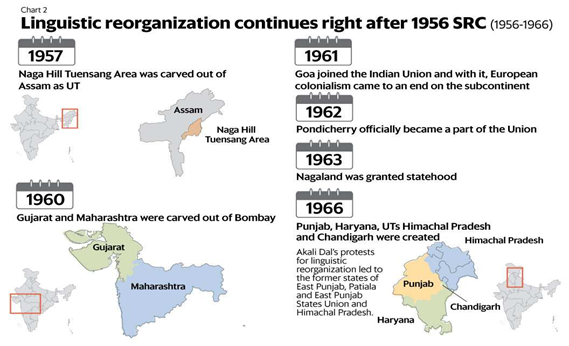
State Reorganization Commission (SRC):
- At the time of independence in 1947, India had more than 500 disjointed princely states. Temporarily the constituent units of India were divided into Part A, B, C, and D states.
- Hence State Reorganization was constituted by the Government of India on 29 December 1953 to look into the matter of redrawing the boundaries of States.
- One of the most popular demands was to reorganize the states based on languages, this was done to make administration easier and to replace controversial caste and religion-based identities with less controversial linguistic identities. The State reorganization commission consisted of H N Kunzru, Fazal Ali and K M Panikkar.
- The commission's recommendations were accepted with some modifications and implemented in the States Reorganisation Act in November 1956.
- Andhra State was the first state of Independent India. Andhra Pradesh was formed on 1st November 1956.
|
Who prepares maps in India?
|
CHANGES AFTER INDEPENDENCE:
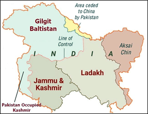
India- Pakistan: State of Jammu and Kashmir
Who drew the partition line?
- In July 1947, about five weeks before the British were scheduled to depart the Indian subcontinent, Sir Cyril Radcliffe, a British lawyer, was commissioned to draw the borders that would divide British India into two countries – Muslim-majority Pakistan and Hindu-majority India.
- The Radcliffe Line was officially announced on August 17, 1947, a few days after the independence of India and Pakistan.
- The Radcliffe line is spread through the Rann of Kutch in Gujarat to the international border in Jammu in Jammu & Kashmir, dividing India and Pakistan into two different countries.
Instrument of Accession:
- The king of this state signed the "Instrument of Accession" to India and became part of the Indian Union. In 1956 J&K completed the process of merging with the Indian Union. Now this state is bifurcated and Ladakh and J&K are the separate union territories since August 2019.
Major wars over Territories:
- Territorial disputes over the Kashmir region sparked two of the three major Indo-Pakistani wars in 1947 and 1965, and a limited war in 1999.
- Although both countries have maintained a fragile cease-fire since 2003, they regularly exchange fire across the contested border, known as the Line of Control.
- The Line of Control (LoC) emerged from the 1948 ceasefire line negotiated by the United Nations (UN) after the Kashmir War.
- It was designated as the LoC in 1972, following the Shimla Agreement between the two countries.
- LoC is delineated on a map signed by the Director General of Military Operations (DGMO) of both armies and has the international sanctity of a legal agreement.
How Line of Control has changed in 74 years?
- In 1947, 65 per cent area of Jammu and Kashmir was under India's control. Today, only 45 per cent of the princely state area is under its control.
Key Moments:
- “Karachi Agreement” of 1949 brought first war to end and defined a ceasefire line:
- This agreement was signed after the India-Pakistan war of 1947 and supervised by the United Nations Commission for India and Pakistan.
- A ceasefire line (CFL) was drawn depending on the actual positions held by the two armies -- led on both sides by British generals.
- The ceasefire line temporarily bifurcated Jammu and Kashmir with India getting control of about 65 per cent of the state and Pakistan the rest of 35 per cent.
- The ceasefire line was formalised as the Line of Control in the “Shimla Agreement “of 1972:
- This agreement was signed after the Bangladesh liberation war of 1971. The agreement converted the ceasefire line into a Line of Control (LoC).
- There was no LoC before the 1972 Shimla Agreement was signed between India and Pakistan. This agreement also practically junked the UN resolution as the two countries agreed to resolve all disputes through bilateral talks.
- The Line of Control, thus drawn, gave Pakistan control over Pakistan-occupied Kashmir and Gilgit-Baltistan, which Pakistan has since declared the Northern Areas and rules directly.
- India established its base in Siachen in 1984 to thwart Pakistan's surreptitious design:
- Siachen glacier came into the focus of the Pakistan Army in the 1970s, following the massive defeat in the 1971 war.
- The entire Siachen Glacier, with all major passes, is currently under the administration of India since 1984 (Operation Meghdoot).
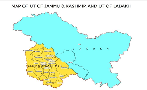
Formation of Union Territories of Jammu Kashmir and Ladakh:
- On the recommendation of Parliament, Article 370 was dismantled from the Indian Constitution, resulting in the formation of the Jammu and Kashmir Reorganization Act, 2019.
- The former state of Jammu & Kashmir was reorganized as the new Union Territory of Jammu and Kashmir and the new Union Territory of Ladakh on 31st October 2019.
- The new Union Territory of Ladakh consists of two districts of Kargil and Leh. The rest of the former State of Jammu and Kashmir is in the new Union Territory of Jammu and Kashmir.
|
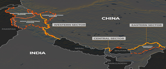
India-China Border:
- Himachal Pradesh, Uttarakhand, Sikkim and Arunachal Pradesh and a Union Territories of Ladakh (erstwhile state of Jammu & Kashmir) share a border with China.
- The two Asian neighbours share a 3,500-kilometre unmarked border through the Himalayas, but an uneasy peace has held since the two countries signed a truce following a war in 1962.
- The Sino-Indian border is generally divided into three sectors namely: The western sector, the Middle sector, and the Eastern sector.
-
- Eastern sector - Arunachal Pradesh: Arunachal Pradesh, which shares a 1,129km border with China, forms part of the Eastern sector. It runs from the eastern limit of Bhutan to a point near the Talu Pass at the trijunction of Tibet, India and Myanmar. This boundary line is called McMahon Line.
- Central or Middle sector - Doklam Plateau: The Central sector is the shortest with a distance of 89km. Fights erupted at Nathu La Pass in the Indian state of Sikkim between Indian and Chinese soldiers. The sector has remained largely peaceful but it was the site of a weeks-long confrontation in 2017 at the Doklam Plateau, which is at the trijunction of India, China and Bhutan.
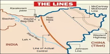
- Western sector – Ladakh: In the western sector, India shares about 2152 km long border with China. In this sector, there is a territorial dispute over Aksai Chin. India claims it as part of erstwhile Kashmir, while China claims it is part of Xinjiang.
Historical Perspective:
- China has never recognised the 1914 border drawn by British officer Henry McMahon.
- China currently claims 90,000 square kilometres of territory - nearly all of which constitutes India's Arunachal Pradesh state. Beijing shows it as Southern Tibet on its map.
- During the time of British rule in India, two borders between India and China were proposed- Johnson’s Line and McDonald Line.
|
|
Past clashes with China: India and China have mostly avoided border clashes since the 1962 truce. Border protocols agreed after several rounds of talks since the late 1980s have largely prevented violence except for episodic border standoffs. 1. 1962 Sino-Indian War 2. 1967 Nathu La Clashes 3. 1975 Tulung La ambush 4. 2017 Doklam Standoff 5. 2020- Ladakh confrontation |
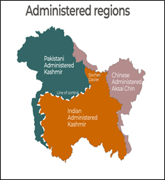
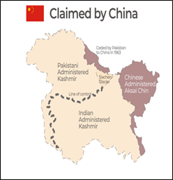
Territorial claims with China over Kashmir:
- A small portion of Kashmir, called Aksai Chin, is in the control of China.
Present Status:
- India’s border dispute with China extends all along the Himalayan range. China still claims large parts of Arunachal Pradesh on its official maps.
- The 1962 war allowed China to consolidate its position in Aksai Chin. India claims Aksai Chin as part of Ladakh but China claims it as its territory and had been making incursions since the 1950s, before cementing its hold in
1962.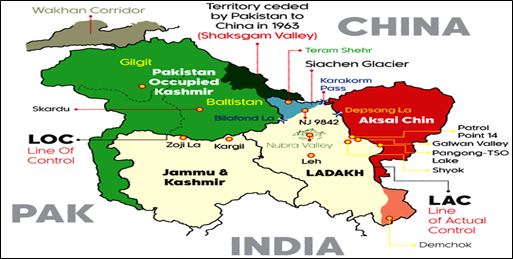
China’s Five Finger Policy: The Five Fingers Policy of China is a foreign policy envisioned by its erstwhile leader Mao Zeadong. He believed that while Tibet was the right hand of China, Sikkim, Arunachal Pradesh, Bhutan, Nepal and Ladakh where it’s ‘five fingers’ of its periphery and that it was China’s duty to ‘liberate’ these areas.
India- Bangladesh:
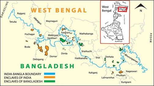
- India and Bangladesh have a land boundary of approximately 4,100 km. This boundary was determined by the 1947 Radcliffe Award as the India-East Pakistan land boundary, but disputes quickly arose regarding certain aspects.
- Some boundary disputes between India and Bangladesh were resolved by the implementation of the historic “Land Boundary Agreement”.
- During the visit of the Indian Prime Minister to Bangladesh in June 2015, the Land Boundary Agreement between India and Bangladesh of 1974 and its Protocol of 2011 were ratified.
- In 1974, a Land Boundary Agreement (LBA) was designed which clarified the need to exchange 111 Indian enclaves in Bangladesh and 51 Bangladeshi enclaves in India. In these enclaves, citizens were living with no available rights and facilities.
|
About Enclave:
|
- The India-Bangladesh Land Boundary Agreement (LBA) came into force following the exchange of instruments of ratification in June 2015. The implementation of the Agreement and Protocol has settled all outstanding land boundary issues between India and Bangladesh.
Other major External Territorial Changes:
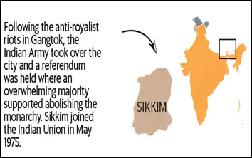
Sikkim (1975):
- The period between the 1950s and the 1970s marked growing discontent in Sikkim. Primarily, there was anger against the monarchy because of growing inequality and feudal control.
- A referendum was held in 1975 where an overwhelming majority voted in favour of abolishing the monarchy and joining India.
- A total of 59,637 voted in favour of abolishing the monarchy and joining India, with only 1,496 voting against it.
- On May 16, the Indian parliament announced that Sikkim officially became a state of India. Sikkim was merged with the Indian Union on 16 May 1975.
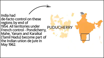
Pondicherry (1962):
- On 16 August 1962 India and France exchanged the instruments of ratification under which France ceded to India full sovereignty over the territories it held.
- Pondicherry and the other enclaves of Karaikal, Mahe and Yanam came to be administered as the Union Territory of Puducherry on 1 July 1963.
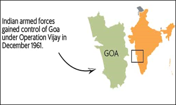
Goa (1961):
- The tension between the two countries came to a head on December 18, 1961, when Indian troops supported by naval and air forces invaded and occupied Goa, Daman, and Diu. All three territories subsequently became part of India. Goa became a state in 1987.
North-East States:
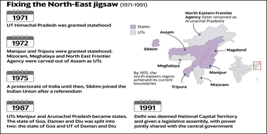
- The ’80s saw the birth of two more north-eastern states when Manipur and Arunachal Pradesh were granted statehood in 1987 (they were UTs earlier).
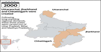
- The next changes to the boundaries happened in the first year of the millennium, with Uttaranchal, Jharkhand and Chhattisgarh carved out of Uttar Pradesh, Bihar, and Madhya Pradesh, respectively.
- Unlike the linguistic basis for states in the ’60s, these states were created to address long pending regional demands and inequalities in regional development.
- Telangana: It was too formed based on such demands in 2014. This was the 29th state of India. It is made by taking some districts of Andhra Pradesh. It got full statehood on 2nd June 2014.
Conclusion:
- India’s external boundaries have been relatively stable since the mid-eighties but there was considerable flux till that time. Through conquests, wars, and accessions, India both gained and lost significant chunks of territories in the first few decades following India’s independence in 1947.
- Maps are beautiful things. A picture speaks a thousand words; a cartographic projection can speak a million. Indeed, maps are treasure troves of information, especially if you're trying to understand history.
Related Articles