
25th February 2023 (6 Topics)
Context
India’s plans to build a multipurpose project on the Ujh river in Jammu & Kashmir for irrigation and hydro power and the second Sutlej-Beas link project in Punjab, so as to better utilise Indus river waters currently flowing to Pakistan is suffering hindrance.
About
- The finance ministry’s Public Investment Board (PIB) has not cleared the strategic Ujh project on the ground that it is not financially viable.
- Also the Sutlej-Beas link project is facing land acquisition issues in Punjab as well as delay in finalisation of the location of its barrage.
Significance of on-going projects:
- The dam at Ujh (a tributary of Ravi), the second Sutlej-Beas link project, along with a third ongoing dam project in Shahpur Kandi in Punjab, are all on the eastern rivers of the Indus basin and are key to India’s aim of utilising the water it is guaranteed under the 1960 Indus Waters Treaty with Pakistan.
- The three projects — Shahpur Kandi, Ujh and the second Sutlej-Beas link — will help India utilise the remaining 5 per cent of water that currently flows into Pakistan.
The Indus Water Treaty 1960:
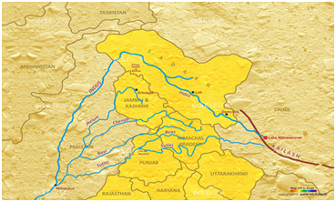
- The six-decade-old treaty governs the sharing of waters of six rivers in the Indus system between the two countries.
- Main Rivers: Indus River, Jhelum, Chenab, Ravi, Beas, and Sutlej.
- The basin is mainly shared by India and Pakistan with a small share of China and Afghanistan.
- Under the treaty signed between India and Pakistan in 1960, all the waters of
- Eastern rivers, namely Ravi, Sutlej, and Beas (Eastern Rivers) were allocated to India for exclusive use
- Western rivers - Indus, Jhelum, and Chenab were allocated to Pakistan except for specified domestic, non-consumptive, and agricultural use permitted to India as provided in the Treaty.
- India has also been given the right to generate hydro electricity through run-of-the-river (RoR) projects on the Western Rivers which, subject to specific criteria for design and operation is unrestricted.
|
River Indus: Geographic Location:
|


