

Published: 22nd Dec, 2022
Context
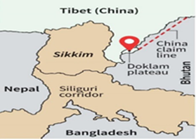
According to defence sources, China has set up a ropeway near the India-Bhutan-China tri-junction and is strengthening roads and other infrastructure along the entire eastern sector.
About
More about the news:
- The People’s Liberation Army (PLA) has installed a ropeway close to the Torsa Nalaon their side near the confluence point (India-Bhutan-China tri-junction).
- A tripoint, trijunction, triple point, or tri-borderarea is a geographical point at which the boundaries of three countries or subnational entities meet.
- There has been hectic activity and construction along the eastern sector.
India-China Border:
- India shares 3488 Km of the border with Chinathat runs along the States of Jammu & Kashmir, Himachal Pradesh, Uttarakhand, Sikkim, and Arunachal Pradesh.
- Both countries have differing perceptionsowing to the Un-demarcated boundary, which leads to transgressions and face-offs as each side patrols up to the areas.
- Border Guarding Force: The Indo-Tibetan Border Police Force (ITBP) is the Border Guarding Force at Indo-China Border.
- Line of Actual Control (LAC): It is divided into the western (Ladakh), middle (Himachal Pradesh and Uttarakhand), and eastern (Arunachal Pradesh and Sikkim) sectors.
- LAC in the eastern sector consisting of Arunachal Pradesh and Sikkim is called the McMahon Line which is 1,140 km long.
|
McMahon Line |
Line of Actual Control |
|
|
- India and China have mutually agreed on disputed areas and areas of differing perception along the 3,488 km-long LAC.
- For instance, in eastern Ladakh, there are two mutually agreed disputed areas, Trig Heightsand Demchok, while there are 10 areas of differing perception. Similarly, Yangtse is one of the eight major friction points in the eastern sector.
Some Strategic Constructions by China:
- Railway Line: In 2020, China had begun work on a strategically significant railway line that will link Sichuan province with Nyingchi in Tibet, which lies close to the Arunachal Pradesh border.
- New Villages: In January 2021, there were reports of the Chinese construction of three villages in Arunachal Pradesh 5 kilometres from the Bum La pass.
- Bridge across Pangong Lake: China is building a new bridge on Pangong Tso which will provide an additional axis to deploy troops faster between the north and south banks of the lake, and closer to the LAC (Line of Actual Control).
Current Areas of a dispute between India & China
- In the Western sector: Here India shares a 2152 km long border with China, and territorial disputes over the Aksai Chin region of Jammu and Kashmir, with both countries claiming the region as their own.
- In the middle sector: Here India roughly shares about a 625 km long boundary with China with a few minor disputes regarding Tibet.
- In the Eastern Sector: The major dispute here is around the region of Tawang Valley of Arunachal Pradesh, Chumbi Valley (Dokalam Tri-Junction) which India shares with Bhutan.