
Published: 12th Nov, 2019
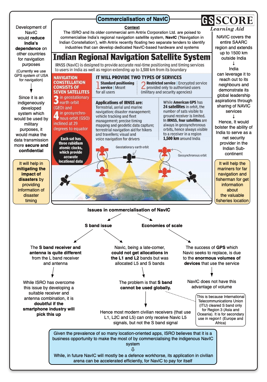
The Indian Space Research Organisation and its older commercial arm Antrix Corporation Ltd. are poised to commercialise India’s regional navigation satellite system, NavIC, with Antrix recently floating two separate tenders to identify industries that can develop dedicated NavIC-based hardware and systems.
Issue
Context
The Indian Space Research Organisation and its older commercial arm Antrix Corporation Ltd. are poised to commercialise India’s regional navigation satellite system, NavIC, with Antrix recently floating two separate tenders to identify industries that can develop dedicated NavIC-based hardware and systems.
Background
- ISRO and Antrix are set to commercialise India’s regional navigation satellite system, NavIC.
- NavIC which essentially means ‘Navigation in Indian Constellation’ is the Indian system of eight satellites that is aimed at telling business and individual users where they are, or how their products and services are moving.
- It is an indigenous positioning or location based service (LBS) and works just like the Global Positioning System (GPS), but within a 1,500-km radius over the Indian sub-continent.
- NavIC can work with global navigation satellite systems of Europe (Galileo), Russia (GLONASS), China (Beidou) and GPS (US).
- All other global systems like Glonass, GALILEO and Beidou operate on L1 and L2 frequencies. L2 is solely meant for US Defence use.
- For civilian usage, the new GPS satellites use L5 and L2C band.
- Navic operates on L5 and S bands.
- NavIC has been certified by the 3GPP (The 3rd Generation Partnership Project), a global body for coordinating mobile telephony standards.
Analysis
Potential for NavIC use in civilian arena?
- Some potential applications of the regional navigation system include:
- Terrestrial, aerial and marine navigation;
- Disaster management;
- Vehicle tracking and fleet management;
- Integration with mobile phones;
- Precise timing (as for ATMs and power grids);
- Mapping and geodetic data capture;
- Terrestrial navigation aid for hikers and travellers;
- Visual and voice navigation for drivers.
- Precision surveys
- Transporters of resources such as mined ore, coal and sand in various states currently use GPS-based systems to check pilferage and fudging. NavIC can be used in these sectors as a vehicle tracking application that is tied to revenue sharing systems of the government.
- Recently the government mandated that all national-permit vehicles must have tracking devices. As a pilot, many fishing boats were fitted with these devices that have a unique texting facility. NavIC will be used in extending this facility.
- Lately NavIC was used to assess safety of unmanned level crossing.
- NavIC support would be available for Original Equipment Manufacturers (OEMs). This will enhance the use of NavIC on mobile, automotive and Internet of Things (IoT) devices.
- Since now Indian companies and start-ups can do the designing part, the potential market for NavIC-based products and integrated circuits can be very large.
- Isro wants chipmakers to integrate NavIC in all upcoming handsets that would be sold in India. Now, Qualcomm Technologies, Inc. (a leading producer of semiconductor chips) is set to add NavIC-chipsets across its user base.
|
Original Equipment Manufacturer (OEM) is a company that manufactures or develops something that is sold by another company under their own name and branding. In the computer world, it can refer to both hardware and software. Example: Apple does not make all the components in an iMac. While Apple designs the computer, it incorporates components from other manufactures. An iMac might contain an Intel processor and Micron RAM. In this case, Intel and Micron are processor and micron OEMs, respectively. L band refers to the operating frequency range of 1–2 GHz in the radio spectrum. The wavelength range of L band is 30–15 cm. The L band is one of the chief operating ranges used by various applications such as radars, global positioning systems (GPS), radio and telecommunications, and aircraft surveillance. The L band has a low bandwidth due to its low frequency, and is the easiest to implement for many applications due to this low frequency. The equipment needed is less sophisticated less expensive. |
Will commercialisation of NavIC be a success?
- No advantage economies of scale: The success of GPS, which Navic seeks to replace, is due to the enormous volumes of devices that use the service. Commercially the biggest users of GPS are the positioning, navigation and location industries. Today every smartphone has a GPS chip inbuilt that provides location and navigation services free of cost via Google Maps. Augmented Reality apps using GPS make for a very powerful and useful handheld device. NavIC does not have this advantage of volume
- NavIC was a late-comer: Navic, being a late-comer, could not get allocations in the L1 and L2 bands but was allocated L5 and S bands. The problem is that S band cannot be used globally. This is because International Telecommunications Union (ITU) cleared S band only for Region 3 (Asia and Oceania). It is for secondary use in region1 (Europe and Africa). Hence most modern civilian receivers (that use L1, L2C and L5) can only receive Navic L5 signals, but not the S band signal.
- S band Antenna issue: The S band receiver and antenna is quite different from the L band receiver and antenna. While ISRO has overcome this issue by developing a suitable receiver and antenna combination, it is doubtful if the smartphone industry will pick this up. Hence, Indian users may have to use a separate global smartphone when they go abroad. But if ITU opens up S band, this issue can be resolved.
- NavIC- a defence workhorse: The evolution of NavIC centres on the need for precision data during the Kargil war. This was then an exclusivity only of the US Defence forces, and was denied by the US. The sovereign need for precision data in modern warfare including missile control led to the evolution of NavIC. Hence commercialisation of Navic is only an value addition, because mainly Navic will become the workhorse for the Defence forces.
Conclusion
Given the prevalence of so many location-oriented apps, ISRO believes that it is a business opportunity to make the most of by commercialising the indigenous NavIC system. While, in future NavIC will mostly be a defence workhorse, its application in civilian arena can be accelerated efficiently, for Navic to pay for itself.
Learning Aid