

Published: 16th Jul, 2022
Context
After the sweltering heatwave, the monsoons have finally hit India. However, monsoon has brought with it new problems in the form of flash floods in the different parts of the country.
Background
|
India is a peninsular country surrounded by the Indian Ocean, Arabian Sea and Bay of Bengal. This geographical placement makes the country prone to floods. |
- Earlier, the floods used to be purely anthropogenic factors and not heavy downpours.
- But over the last four decades, India has been reeling from the effects of climate change like many parts of the world.
- The global rise in temperatures has led to large periods of no rain followed by extreme precipitation, an observation which is becoming a trend.
- A case in point is the southwest monsoon period in India from June to September during which the country receives the bulk of its rainfall.
- The rains bring relief from scorching heat to millions in the country but have also been causing massing floods in parts of the country in recent years.
|
Global rainfall data for over the last century also shows an alarming trend. The number of rainy days is decreasing while intense rainfall events of 10-15 centimetre per day are increasing. This means that more amount of water is pouring down in lesser time. For example, globally, 50 per cent of annual precipitation (rain, snow and ice) is received in just 11 days. |
Analysis
Understanding floods
- Floods are natural disasters affecting the crops, livestock, infrastructure, and human beings.
- Rainfall of about 15cm or more in single day causes flood.
- Floods occur when water bodies like rivers carry more amount of water than their capacities and when this additional water cannot be drained in a proper manner.
- Today, the destruction caused by floods is immense because of creased population density and spread of people in every part of the country.
|
Types of Floods in India:
1.Coastal (Surge Flood):
2.Fluvial (River Flood):
3. Pluvial (Surface Flood):
|
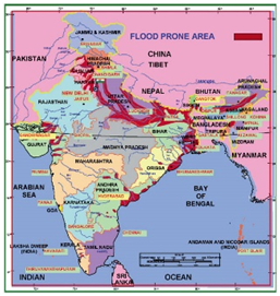
Which regions are susceptible to floods?
|
The most flood-affected state in India falls under the Ganga River basins and Brahmaputra. The Indo-Gangetic- Brahmaputra plains in North and Northeast India carry nearly 60% of India’s total river flow. |
- Northern states: Himachal Pradesh and Punjab, covering Uttar Pradesh and Bihar. Cloudburst and torrential rainfall have caused flood in Uttarakhand and Kashmir.
- Northeast: Assam and Arunachal Pradesh
- Coastal states: The coastal states of Odisha and Andhra Pradesh, parts of Telangana and Gujarat also witness yearly floods.
- The small rivers of Kerala, originating in Western Ghats and flowing to the Arabian Sea, cause considerable damage when in spate.
- The deltaic region of the Mahanadi, the Godavari, the Krishna and the Kaveri suffer from occasional food owing to the large-scale silting and consequent change in the river course.
Why Parts of India are seeing extreme rainfall & floods?
- Climate change: Rise in average global temperatures have led to a worrying trend of no rain for long periods and then a sudden bout of excessive rainfall, causing extreme weather events.
- Increased warming: While the frequency of low-pressure systems in the Bay of Bengal has declined, this extra moisture is transported in from the Arabian Sea. Monsoon winds (westerlies) over the northern Arabian Sea are exhibiting increased variability (large fluctuations), driving surges of moisture supply, leading to extreme rain episodes across the entire central Indian belt.
- Poleward shift in LLJ: A poleward shift in the monsoon low level jetstream (LLJ), which transports moisture from surrounding oceans to the Indian land mass, has been detected.
- The poleward shift is reflected in the future projections in a warming scenario, with the magnitude of shift depending on the degree of warming.
- Strengthening of the cross-equatorial sea-level pressure gradient: Enhanced land-sea contrast resulted in a strengthening of the cross-equatorial sea-level pressure gradient over the Indian Ocean, resulting in the northward shift of the zero absolute vorticity contour from its climatological position.
Other reasons of increasing Flood in India:
- Callous urbanisation: With a massive surge in urbanisation — an increase in built-up area undermines natural drainage systems.
- Excessive mining: Excessive sand mining can alter the river bed, force the river to change its course, erode banks and lead to flooding.
- Rapid development: Increasing development of infrastructure may be creating problems in places where they did not exist earlier.
- Unsustainable human activities
- Others:
- wide variations in rainfall both in time and space with frequent departures from the normal pattern
- inadequate carrying capacities of rivers
- river bank erosion and silting of river beds
- landslides
- poor natural drainage in flood prone areas
- snowmelt and glacial lake out-bursts
Example
In 2020, the glacial burst in the Chamoli district of Uttarakhand in India is an example of the imbalance in ecological processes caused by human activities.
Assessing the impacts
- Human cost: All natural disasters, including floods extract heavy human costs.
- Impact on agriculture: Floods are now increasingly affecting the non-farm sector in India.
- Threats to coastal cities: India’s largest coastal cities, like Mumbai and Kolkata, are facing the severest threats from climate-induced flooding.
- Economic loss: The prospect of greater wealth destruction during natural disasters is also worse news for the Indian economy.
Important Flood Control Measures taken by Government
|
The Central Water Commission (CWC) is the nodal agency entrusted with the task of flood forecasting and early flood warnings. |
Being a natural phenomenon, the total elimination or control of floods is neither practically possible nor economically viable. Hence, flood control measures aim at providing a reasonable degree of protection against flood damage at economic costs. The various control measures of flood adopted by government and citizens:
- Dam construction: The government has constructed many dams and authorities which includes
- Damodar Valley Corporation for Damodar River
- Narmada Control Authority for Narmada River
- Hirakund dam on Mahanadi
- Ukai dam on the Taps
- Bhakra dam across Sutlej
- Steps for flood control: The Central Water Commission and National Flood Control Board in partnership with the National Disaster Management Authority (NDMA) has taken many steps for flood control.
- Among other structural measures, flood embankments, flood banks and levees have been constructed all along the major rivers, so that excess water in their channel does not cause havoc a nearby areas.
- Diversion of water flow: The flood spill channel skirting Srinagar city and the Supplementary Drain in Delhi are examples of diverting excess water to prevent flooding of the urbanized areas.
- Forecasting:India Meteorological Department (IMD) issues flood forecasting and warning which are of immense help in relocation of the vulnerable section of population.
- Further, many watershed developments projects have been taken up under MGNREGA, which will eventually help in controlling the flood.
Where does lie the solution?
- Planting Mangroves
- Optimizing Technology
- Taking Structural and Non-Structural Measures
- Structural measures (such as redesigning buildings or designing physical barriers to disasters)
- Non-structural measures (planning evacuation, preparing for emergency situations in flood)
Conclusion
As floods cause major damage to life and property every year. It is time the Central and the State governments prepare a long-term plan that goes beyond piecemeal measures like building embankments and dredging to control floods.
Also, there is a need for an integrated basin management plan that brings all the river-basin sharing countries as well Indian states.