

Published: 6th Apr, 2023
Context
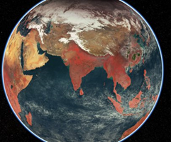
The Indian Space Research Organisation (ISRO) has released images of Earth captured by the EOS-06 satellite in 13 distinct wavelengths to provide information about global vegetation cover on Land and Ocean Biota for global oceans.
About
- The images are a mosaic generated by the ISRO’s National Remote Sensing Centre (NRSC).
- NRSC/ISRO has generated a global False Colour Composite (FCC) mosaic from the images captured by the Ocean Colour Monitor (OCM) payload on board EOS-06.
About EOS-06 satellite:
- EOS-06, also called OceanSat-3, is a nanosatellite which was launched by ISRO, as part of the PSLV-C54 mission in 2022.
- EOS-06 provides continued services of Oceansat-2 with enhanced payload capability and carries four payloads OCM-, Sea Surface Temperature Monitor, Ku-Band Scatterometer, and ARGOS.
- The EOS-06 is envisaged to observe ocean colour data, sea surface temperature and wind vector data to use in Oceanography, climatic and meteorological applications.
- The satellite also supports value added products such as potential fishing zone using chlorophyll, SST and wind speed and land based geophysical parameters.
What is an Earth Observation satellite?
- Earth Observation (EO) satellites are designed for earth observation from space, which includes military use like spying and civilian uselike, meteorology and cartography.
- These satellites make essential information available on a vast number of areas, including; ocean salinity, ice thickness, crop health, and air quality.
- The data from these satellites are used for several applications like agriculture, urban planning, rural development, mineral prospecting, environment, forestry, ocean resources and disaster management.
Needs Earth Observation Satellites:
- To counter China: The foremost reason to have them is that the People Republic of China(PRC) has many of these EOS. In 2020 the troops' movement by the People Republic of China (PRC) in the Ladakh region went largely undetected because of the lack of a sufficient number of EOS. They have Gafoen series of EO satellites.
|
Gaofen is a series of Chinese high-resolution Earth-imaging satellites for the state-sponsored program China High-resolution Earth Observation System (CHEOS). The first satellite in the Gaofen, Gaofen 1 was launched in 2013. |
- The Gafoen series is also associated with its military reconnaissance missions. This is certainly a threat and we need to have a robust surveillance system in place. India has to respond to the capabilities of China with which we frequently experience border clashes.
- Surveillance in the Indian Ocean Region: In addition to the threat on its Himalayan borders with China, there is also a significant increase in its influence in Indian Ocean Region has been reported. This need to be taken care of by the use of advanced surveillance systems.
- To overcome limitations of drones and UAVs: Using UAVs (unmanned aerial vehicles) and drones has its demerits as they can be shot down if the reconnaissance mission needs to be carried out over the military installations of the adversary.
- Whereas, the satellite imagery will have the capability to zoom into the most remote corners, which can help our security forces to take timely action and track suspicious movements.
- Use of satellites for Border management: India also needs to beef up its anti-infiltration grid along the Pakistan and Bangladesh border, as infiltration and smuggling along the line of control have always been a threat to national security.
- Post-attack assessment: This is crucial for post-attack damage assessment and will enable us to create opportunities to refine our attacks against enemy targets in the future.