

Published: 12th Jan, 2023
Context
Joshimath, the ancient Uttarakhand town has become a cause of concern. Though the town of Joshimath has been witnessing cracks emerging for the past two decades, things have escalated over a few days when the area was declared a disaster prone region.
Journey of Joshimath Town’s development:
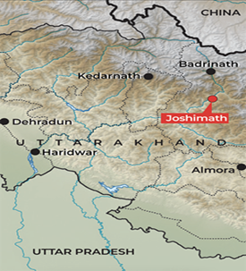
- Joshimath is a busy town in Chamoli district.
- The region is the part of the Himalayan ecosystem.
- Despite a population of only about 23,000, it has been heavily built-on, with hotels, resorts, and a bustling market that caters mainly to tourists, pilgrims, trekkers and personnel of the army and the Indo-Tibetan Border Police (ITBP).
- After the 1962 India-China war, Joshimath emerged as a place of strategic importance.
- It leads to villages along the India-China border and is also en route to Barahoti, a disputed territory along the border.
- The town is also a gateway to noted sites such as;
- The pilgrimage – Badrinath for Hindus and Hemkund Sahib for Sikhs;
- The international skiing site of Auli; and
- The Valley of Flowers, a UNESCO World Heritage site.
- Today, Joshimath is overly burdened with structures built without any regard for the land’s load-bearing capacity.
- The signs of sinking first appeared in October 2021, when cracks continued to appear around town and residents resorted to repairs.
- The situation became particularly alarming towards the end of 2022 and the beginning of 2023, when large parts of the town experienced sudden land-sinking and several houses developed major cracks as well.
Reasons for Vulnerability of region:
- Joshimath is built on the deposits of an old landslide, which means the slopes can be destabilised even by slight triggers.
- The town is also in Zone V, denoting highest risk, in India’s seismic zonation scheme.
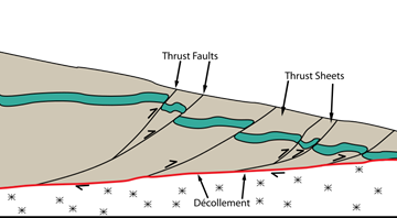
- It lies between two thrusts, the Main Central Thrust (MCT) and the Vaikrita Thrust (VT), and thus occupies a seismically active terrain.
Main Central Thrust (MCT) line:
- In simplest terms, the MCT is a crack or geological fault in Himalayas.
- It is formed due to the collusion of Indo-Australian plate and Eurasian plate.
- The area underneath the MCT is particularly very fragile due to frequent tectonic activities.
- And, therefore, seismic activities are very common in MCT areas.
- The MCT extends for over 2200 km across the Himalayas in northwest-southeast direction. Joshimath is located above the MCT.
|
The M.C. Mishra committee’s report of 1976 warned against heavy and unscientific construction in the town mentioning that, “Joshimath is a deposit of sand and stone, hence was not a suitable place for the coming up of a township. Vibrations produced by blasting and heavy traffic will also lead disequilibrium in natural factors.” |
Contributing factors for disasters in the region:
- Role of NTPC: Locals have blamed the NTPC’s 520-MW Tapovan Vishnugad hydropower project, under construction in the area, for exacerbating the Joshimath land subsidence.
- Recently, NTPC has punctured a tunnel to connect Auli, near Joshimath for supply of water.
- Char Dham project: The 6-km Helang-Marwari bypass, being built by the Border Roads Organisation (BRO), is also under scrutiny for weakening slopes and further destabilising the local topography.
- The bypass is part of the 825-km Char Dham highway expansion project in Uttarakhand, which experts have already questioned for unscientific slope-cutting, which resulted in several landslides.
- Inadequate drainage and wastewater disposal: The 2022 USDMA report pointed to a lack of drainage and wastewater disposal systems as being part of the subsidence problem.
- About 85% of buildings in the town, including those owned by the army aren’t connected to a sewerage system and have soak pits instead.
The Himalayan ecosystem:
- The Himalayas are ecologically fragile and economically underdeveloped, with geo-environmental constraints imposing severe limitations on the level of resource productivity.
- Consequently, subsistence agriculture constitutes the main source of livelihood in the region.
- The rapid growth of tourists in the region has brought about extensive land-use changes in the region, mainly through the extension of cultivation and large-scale deforestation.
- This irrational land transformation process has not only disrupted the ecological balance of the Himalayan watersheds through reduced groundwater recharge, increased run-off and soil erosion, but has also adversely affected the ecology and economy of the adjoining Indo-Gangetic plains by recurrent floods and decreased irrigation potential.
Why Himalayan region is susceptible to disasters?
The Hindu Kush Himalayan region is prone to numerous types of disasters because of its
- Steep terrain
- fragile geology
- intense and variable precipitation
- Common incidents of floods and landslides
- neo-tectonic mountain-building process, like earthquakes, landslides, floods, etc
- Other factors:
- Overexploitation of the ecosystem(tourism, increased consumerism)
- Exploitative development projects:The indiscriminate exploitation of the fragile Himalayan region in the name of development projects has extracted a heavy price in terms of environmental damage.
- Fragmentation of natural resources:String of hydroelectric and road projects in the Himalayan States have already resulted in the fragmentation of natural systems.
Sustainable tourism in Himalayas: Recommendations
- Regulated tourism practice: There is need to establish regulated tourism practices with promotion of sustainable agendas for the Indian Himalayan region (IHR).
- Also, there is need of maintenance of proper tourist capacity in every tourist place.
- Vigilance and patrolling: Protected areas require vigilance and regular patrolling to reduce unwanted wildlife-tourist interaction as well as habitat destruction due to off-road driving and encroachment.
- Early Warning System: It is important to have early warning and better weather forecast systems in order to forecast the disaster and alert the local population and tourists.
- Regional Cooperation: There is a need for a trans-boundary coalition of Himalayan countries to share and disseminate knowledge about the mountains and preservation of the ecology there.
- Area Specific Sustainable Plan: What is most critical is to review the area’s present status and draw up a sustainable plan that respects the specific requirements of this fragile region and the impact of the climate crisis.
- Promote Ecotourism: Initiating a dialogue on adverse impacts of commercial tourism and promoting ecotourism.
Recent disasters in the region:
- In last ten years, two major earthquakes have occurred in Uttaranchal namely the Uttarkashi earthquake (1991) and the Chamoli earthquake (1999).
- 380 people were killed when massive landslides washed away the whole village Malpa, Uttaranchal (then Uttar Pradesh) in 1998.
- In 1999, forest-fires in the hills of Uttaranchal destroyed more than 3, 75,000 hectares of forest. The same year, more than 450 cases of forest fire were reported in Himachal Pradesh and by May 1999, more than 80,000 hectares of forests were turned to ashes.
- The kedarnath floods in 2013, had took lives of several innocent people and disaster in the region