What's New :

March’s excess rain to ‘affect’ wheat crop

Published: 6th Apr, 2023

Context

While farmers in India look forward to rains every year, the ongoing unseasonal downpour across West and North India has come as a bane that has damaged crops and disrupted the harvest season.  

The damaging combination (Heat+ Rain)

  • Unnaturally high temperature: Before the downpour began in March, India had already experienced the hottest February in over a hundred years. That was critically damning to the wheat crop.
  • Heavy downpour: The high temperature immediately preceded unseasonal downpour.  

While occasional bursts of rainfall are not that much of an issue, the continued rainfall along with high winds has damaged crops across West and North India. These rains came right after premature hot temperatures. The combination is very damaging to wheat.

How wheat gets affected by rain?

  • Wheat is sensitive to both heat stress and rain/ thunderstorms during the terminal grain filling and ripening period.
  • This is the time when the crop’s earheads are heavy with grains.
  • The more the weight accumulated from grain-filling, the more vulnerable is the crop to rain.
  • These, when accompanied by high-velocity winds, make the stems prone to “lodging” or bending and even falling flat on the ground.

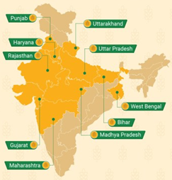
Wheat cultivation in India:

  • Type of Crop: Wheat is a Rabi Crop.
  • Temperature requirements: Between 10-15°C (Sowing time) and 21-26°C (Ripening & Harvesting) with bright sunlight.
  • Rainfall or water requirement: Around 75-100 cm.
  • Soil type: Well-drained fertile loamy and clayey loamy.
  • Major producers: Uttar Pradesh > Punjab > Madhya Pradesh > Haryana > Rajasthan.

Is it going to impact the food security?

  • India has 15 agro-climatic zones, plus there are sub zones too. Unseasonal rainfall or other climatic disasters are limited to some of these areas.
    • An “Agro-climatic zone” is a land unit in terms of major climates, suitable for a certain range of crops and cultivars.
  • Thus, the overall food security is not affected, however, the impact is limited.

India’s Agro-Climatic Zones

  1. Western Himalayan Region: Jammu and Kashmir, Himachal Pradesh and the hill region of Uttarakhand
  2. Eastern Himalayan Region: Arunachal Pradesh, the hills of Assam, Sikkim, Meghalaya, Nagaland, Manipur, Mizoram, Tripura, and the Darjeeling district of West Bengal
  3. Lower Gangetic Plain Region: West Bengal (except the hilly areas), eastern Bihar and the Brahmaputra valley
  4. Middle Gangetic Plain Region: Parts of Uttar Pradesh and Bihar
  5. Upper Gangetic Plains Region: Central and western parts of Uttar Pradesh and the Hardwar and Udham Nagar districts of Uttarakhand
  6. Trans-Ganga Plains Region: Punjab, Haryana, Chandigarh, Delhi and the Ganganagar district of Rajasthan
  7. Eastern Plateau and Hills: Chhotanagpur Plateau, extending over Jharkhand, Orissa, Chhattisgarh and Dandakaranya
  8. Central Plateau and Hills: Bundelkhand, Baghelkhand, Bhander Plateau, Malwa Plateau, and Vindhyachal Hills
  9. Western Plateau and Hills: Southern part of Malwa plateau and Deccan plateau (Maharashtra)
  10. Southern Plateau and Hills: Interior Deccan and includes parts of southern Maharashtra, the greater parts of Karnataka, Andhra Pradesh, and Tamil Nadu uplands from Adilabad District in the north to Madurai District in the south
  11. Eastern Coastal Plains and Hills: Coromandal and northern Circar coasts of Andhra Pradesh and Orissa
  12. Western Coastal Plains and Ghats: Malabar and Konkan coastal plains and the Sahyadris
  13. Gujarat Plains and Hills: Hills and plains of Kathiawar, and the fertile valleys of Mahi and Sabarmati rivers
  14. Western Dry Region: West of Aravalli (Rajasthan)
  15. Island Region: Andaman-Nicobar and Lakshadweep
X

Verifying, please be patient.

Enquire Now