

16th March 2023 (7 Topics)
1
Mar
2
Mar
3
Mar
4
Mar
6
Mar
7
Mar
8
Mar
9
Mar
10
Mar
11
Mar
13
Mar
14
Mar
15
Mar
16
Mar
17
Mar
18
Mar
20
Mar
21
Mar
22
Mar
23
Mar
24
Mar
25
Mar
27
Mar
28
Mar
29
Mar
30
Mar
31
Mar
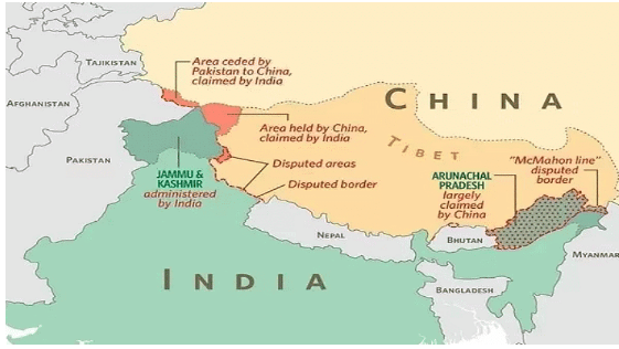
McMohan Line and US Senate resolution
Context
Two United States Senators, have introduced a bipartisan resolution in the upper chamber of Congress reiterating that they recognises the ‘McMahon Line’ as the international boundary between China and India in Arunachal Pradesh.
About the US Senate call:
- The resolution reaffirms India’s well-known and established position that Arunachal Pradesh, which China calls ‘South Tibet’, is an integral part of India.
- The Senate has shown support as unequivocally recognising the state of Arunachal Pradesh as an integral part of India, condemning China’s military aggression to change the status quo along the Line of Actual Control.
- It is further seen as enhancing the US-India strategic partnership and the Quad in support of the Free and Open Indo-Pacific.
What is the McMahon Line?
- The McMahon Line serves as the de facto boundary between China and India in the Eastern Sector.
- It specifically represents the boundary between Arunachal Pradesh and Tibet, from Bhutan in the west to Myanmar in the east.
- China has historically disputed the boundary and claims the state of Arunachal Pradesh as part of the Tibetan Autonomous Region (TAR).
How was McMohan line drawn?
- The McMahon Line was drawn during the Simla Convention of 1914, officially described as the Convention between Great Britain, China, and Tibet.
- The McMahon Line delimited the respective spheres of influence of Tibet and British India in the eastern Himalayan region.
- The border in this region was undefined prior to the signing of the convention.
|
Simla Convention of 1913-14:
|
McMohan line vs. Line of Actual Control (LAC):
|
McMohan line |
Line of Actual Control (LAC) |
|
|
Current Areas of a dispute between India & China:
- In the Western sector: Here India shares a 2152 km long border with China, and territorial disputes over the Aksai Chin region of Jammu and Kashmir, with both countries claiming the region as their own.
- In the middle sector: Here India roughly shares about a 625 km long boundary with China with a few minor disputes regarding Tibet.
- In the Eastern Sector: The major dispute here is around the region of Tawang Valley of Arunachal Pradesh, Chumbi Valley (Dokalam Tri-Junction) which India shares with Bhutan.
More Articles