

Published: 2nd Nov, 2020
Context
After remaining closed for around 7 months due to coronavoirus COVID-19 pandemic, the Indo-Nepal border was reopened but Nepal government has decided to keep the border closed and has deployed police at the border.
How did it all start?
- India and Nepal share a 1,800 km (1,118 mile) border.
- Despite the diplomatic relationship between the two countries, the border dispute is speculated to have started a long time ago.
- A major misunderstanding between India and Nepal occurred when India’s new map was released in November 2019,displaying Kalapani as part of the Indian state of Uttarakhand.
- However, the sudden outbreak of the border dispute was triggered when a new 80 km-long road in the Himalayas, connecting to the border with China, was inaugurated at the Lipulekh Pass.
- Lipulekh, in the Uttarakhand state of India, is a Himalayan pass on the border between India and the Tibet region of China.
- This pass is located near Nepal, not in Nepal. Lipulekh pass was mainly launched for the wellness of pilgrims, as there is no other proper means of road transport present for the pilgrims to reach Kailash.
- So, the Indian government has inaugurated an 80 kilometer long road in the Lipulekh pass for the benefit of pilgrims.
- The new road is now the quickest link between Delhi and the Tibetan plateau in China. Hence, the road serves pilgrims to reach Kailas and Manasarovar with ease.
What are the disputed areas?
- Lipulekh and Kalapani are major regions in India, and the Susta region in Nepal is covered in the border dispute between India and Nepal. The territorial dispute between India and Nepal includes an area of 400 km2at the India-Nepal-China tri-junction region.
- Limpiyadhura is the tri-junction point where the territories of India-Nepal-China meet.
- The Kalapani territoryis a region under Indian administration as a sector of Pithoragarh district in the Uttarakhand state, but has also been claimed by Nepal since 1998.
- However, the Nepal government claims that Kalapani province lies in Darchula district, Sudurpaschim Pradesh.
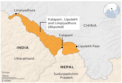
- Kalapani has been controlled by India’s Indo-Tibetan border security forces since 1962.
- But Nepal demands the withdrawal of the Indian border forces in Kalapani area because they are claiming that Kalapani belongs to them.
- However, the Nepal government claims that Kalapani province lies in Darchula district, Sudurpaschim Pradesh.
- Lipulekh is a Himalayan pass situated on the border between Uttarakhand state of India and the Tibetan autonomous region of China, near their trijunction with Nepal.
- Nepal affirms that the southern side of the Lipulekh pass, called Kalapani territory (which is controlled by India), belongs to Nepal.
- The pass is near the Chinese trading town of and it has been used since ancient times by traders, mendicants and pilgrims traveling between India and China.
- Lipulekh pass is also used by pilgrims to reach Kailas and Manasarovar.
- Susta territoryis an area under Nepal province and it is near Nichlaul, Uttar Pradesh, India.
- Susta is a rural municipal region in the Parasi district present in the southern side of Nepal.
- This area under dispute totals over 140 km2 and is being controlled by the Indian Government.