

Published: 18th Nov, 2019
The new political map of India, recently released by the government to account for the bifurcation of Jammu and Kashmir, has triggered fresh protests over an old issue in Kathmandu.
Context
The new political map of India, recently released by the government to account for the bifurcation of Jammu and Kashmir, has triggered fresh protests over an old issue in Kathmandu.
About
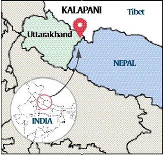
- and Tibet.
- Kalapani is a 35 square kilometre area. The Kali River in the Kalapani region demarcates the border between India and Nepal.
- While the Nepal government and political parties have protested, India has said the new map does not revise the existing boundary with Nepal.
- The Nepal government described India’s decision as “unilateral” and claimed that it will “defend its international border”.
Defining the boundaries
- Nepal’s western boundary with India was marked out in the Treaty of Sugauli between the East India Company and Nepal in 1816.
- Nepali authorities claim that people living in the low-density area were included in the Census of Nepal until 58 years ago.