

Published: 20th Apr, 2023
Context
NISAR satellite is going to map the most earthquake-prone regions in the Himalayas with unprecedented regularity and aims to build an advance warning system of land subsidence and earthquakes.
|
NISAR satellite was jointly developed by the Indian Space Research Organisation (ISRO) and the National Aeronautics and Space Administration (NASA) of the U.S. NISAR is expected to be launched in January 2024 from Satish Dhawan Space Centre into a near-polar orbit. |
About the map:
- Need of the initiative: A large section of the Himalayan region falls in Zone V, implying the highest risk of strong earthquakes.
|
Strain Strain refers to the deformation that occurs in rocks when it is under pressure from other rocks, usually due to movements of continental plates that are sliding, colliding, or subducting against each other. The Indian Plate, for instance, collided into the Eurasian plate forming the Himalayas and continues to incrementally push it upwards. |
- The NISAR satellite will use two frequency bands: the L-band and S-band to image the Himalayan region.
- The geoscience community can use this to determine how strain is building up in various parts of the Himalayas.
- These two frequency bands will together provide high-resolution, all-weather data from the satellite that is expected to follow a sun-synchronous orbit and will be launched in January 2024.
|
About NISAR:
|
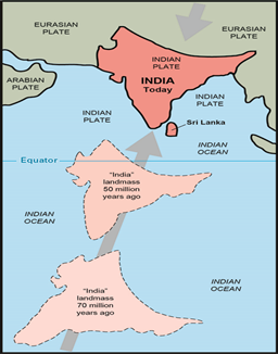
Emergence of Himalayas:
- About 225 million years ago, India was a large island still situated off the Australian coast, and a vast ocean (called Tethys Sea) separated India from the Asian continent.
- When Pangaea broke apart about 200 million years ago, India began to forge northward.
- By studying the history -- and ultimately the closing-- of the Tethys, scientists have reconstructed India's northward journey.
- About 80 million years ago, India was located roughly 6,400 km south of the Asian continent, moving northward at a rate of about 9 m a century.
- When India rammed into Asia about 40 to 50 million years ago, its northward advance slowed by about half.
- The collision and associated decrease in the rate of plate movement are interpreted to mark the beginning of the rapid uplift of the Himalayas.
Himalayas and vulnerability:
- The Himalaya is a fragile mountain range that is still rising as the Indian plate continues to push into the Asian plate.
- The mountains are mainly the shale upwelling of the sea, which makes them quite unstable.
- In fact, they are largely held together by the forests that they support.
Concerns:
- Extreme weather events - With the consequent loss of forest cover and extreme weather events (the 2013 Kedarnath flood), catastrophes have occurred at a steady beat in all of Uttarakhand.
- Soil and water degradation - The local soil and water have been degraded.
- Decline in natural springs - The number of natural mineral water springs is declining.
- Increasing landslides - The number of landslides is also shooting up.