

Published: 17th Jan, 2020
- Since the resolution of the LISS III sensor data is 23.5 m, land cover features having a geometric dimension less than 23.5 m on the ground are not discernible.
- Considerable ground details may sometimes be obscured due to clouds and shadows. Such areas can be discerned to a certain extent with the help of collateral data and image processing techniques, but not always.
- Non-availability of appropriate season data sometimes puts constraints on the interpretation of the features owing to poor reflectance of data and phenological changes in forests.
- Occurrence of weeds like lantana in forest areas and agricultural crops like sugarcane, cotton, etc adjacent to forests, causes mixing of spectral signatures and often make precise forest cover delineation difficult.
- Young plantations and tree species with less chlorophyll or inadequate foliage, many a times are not discernable on satellite images due to inadequate reflectance.
- Haze and other atmospheric distortions pose difficulty in interpretation, especially in the coastal areas.
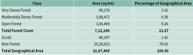
Forest Cover of India
Related Articles