Geography: Basics of Geomorphology
Rocks and Minerals
Rocks
- The Earth’s crust is composed of rocks.
- A rock is an aggregate of one or more minerals.
- Rock may be hard or soft and in varied colors. For example, granite is hard, soapstone is soft. Gabbro is black and quartzite can be milky white.
- Rocks do not have definite composition of mineral constituents.
- Feldspar and quartz are the most common minerals found in rocks.
- Petrology is science of rocks.
- A petrologist studies rocks in all their aspects viz., mineral composition, texture, structure, origin, occurrence, alteration and relationship with other rocks.
Type of Rocks
- There are many different kinds of rocks which are grouped under three families on the basis of their mode of formation. They are:
- Igneous Rocks — solidified from magma and lava;
- Sedimentary Rocks — the result of deposition of fragments of rocks by exogenous processes;
- Metamorphic Rocks — formed out of existing rocks undergoing recrystallization.
Igneous Rocks
- As Igneous rocks form out of magma and lava from the interior of the earth, they are known as primary rocks.
- The Igneous rocks (Ignis – in Latin means ‘Fire’) are formed when magma cools and solidifies and when magma in its upward movement cools and turns into solid form forming Igneous Rocks
- The process of cooling and solidification can happen in the earth’s crust or on the surface of the earth. Igneous rocks are classified based on texture. Texture depends upon size and arrangement of grains or other physical conditions of the materials.
- If molten material is cooled slowly at great depths, mineral grains may be very large. Sudden cooling (at the surface) results in small and smooth grains. Intermediate conditions of cooling would result in intermediate sizes of grains making up igneous rocks.
- Granite, gabbro, pegmatite, basalt, volcanic breccia and tuff are some of the examples of igneous rocks.
Types of Igneous Rocks:
Based on place and time taken in cooling of the molten matter, igneous rocks can be divided into Plutonic and Volcanic rocks.
-
- Plutonic Rocks or intrusive rocks:
- Sometimes, the molten matter is not able to reach the surface and instead cools down very slowly at great depths.
- Slow cooling allows big-sized crystals (large grains) to be formed.
- Granite is a typical example. These rocks appear on the surface only after being uplifted and denuded.
- Lava or Volcanic Rocks or Extrusive rocks:
- These are formed by rapid cooling of the lava thrown out during volcanic eruptions.
- Rapid cooling prevents crystallization; as a result such rocks are fine-grained. Basalt is a typical example.
- The Deccan traps in the peninsular region are of basaltic origin.
- Basic rocks contain a greater proportion of basic oxides, e.g. of iron, aluminum or magnesium, and are thus denser and darker in color.
Based on the presence of acid forming radical, silicon, igneous rocks are divided into Acid Rocks and Basic Rocks.
-
- Acid Rocks:
- These are characterized by high content of silica—up to 80 per cent, while the rest is divided among aluminum, alkalis, magnesium, iron oxide, lime etc.
- These rocks constitute the Sial portion of the crust.
- Due to the excess of silicon, acidic magma cools fast and it does not flow and spread far away.
- High mountains are formed of this type of rock.
- These rocks have a lesser content of heavier minerals like iron and magnesium and normally contain quartz and feldspar.
- Add rocks are hard, compact, massive and resistant to weathering.
- Basic Rocks:
- These rocks are poor in silica (about 40 per cent); magnesia content is up to 40 per cent and the remaining 40 per cent is spread over iron oxide, lime, aluminum, alkalis, potassium etc.
- Due to low silica content, the parent material of such rocks cools slowly and thus, flows and spreads far away.
- This flow and cooling gives rise to plateaus. Presence of heavy elements imparts to these rocks a dark color.
- Basalt is a typical example, others being gabbro and dolerite. Not being very hard, these rocks are weathered relatively easily.
- Sedimentary Rocks
- The word ‘sedimentary’ is derived from the Latin word sedimentum, which means settling. Rocks (igneous, sedimentary and metamorphic) of the earth’s surface are exposed to denudational agents, and are broken up into various sizes of fragments. Such fragments are transported by different exogenous agencies and deposited. These deposits through compaction turn into rocks. This process is called lithification. In many sedimentary rocks, the layers of deposits retain their characteristics even after lithification. Hence, we see a number of layers of varying thickness in sedimentary rocks like sandstone, shale etc.
- Depending upon the mode of formation, sedimentary rocks are classified into three major groups:
- Mechanically formed — sandstone, conglomerate, limestone, shale, loess etc. are examples;
- Organically formed — geyserite, chalk, limestone, coal etc. are some examples;
- Chemically formed — chert, limestone, halite, potash etc. are some examples.
- Metamorphic Rocks
- The word metamorphic means ‘change of form’. These rocks form under the action of pressure, volume and temperature (PVT) changes.
- Metamorphism occurs when rocks are forced down to lower levels by tectonic processes or when molten magma rising through the crust comes in contact with the crustal rocks or the underlying rocks are subjected to great amounts of pressure by overlying rocks.
- Metamorphism is a process by which already consolidated rocks undergo recrystallization and reorganization of materials within original rocks.
- Mechanical disruption and reorganization of the original minerals within rocks due to breaking and crushing without any appreciable chemical changes is called dynamic metamorphism.
- The materials of rocks chemically alter and recrystallize due to thermal metamorphism. There are two types of thermal metamorphism — contact metamorphism and regional metamorphism.
- In contact metamorphism the rocks come in contact with hot intruding magma and lava and the rock materials recrystallize under high temperatures. Quite often new materials form out of magma or lava are added to the rocks. In regional metamorphism, rocks undergo recrystallization due to deformation caused by tectonic shearing together with high temperature or pressure or both.
- In the process of metamorphism in some rocks grains or minerals get arranged in layers or lines.
- Such an arrangement of minerals or grains in metamorphic rocks is called foliation or lineation.
- Sometimes minerals or materials of different groups are arranged into alternating thin to thick layers appearing in light and dark shades. Such a structure in metamorphic rocks is called banding and rocks displaying banding are called banded rocks.
- Types of metamorphic rocks depend upon original rocks that were subjected to metamorphism. Metamorphic rocks are classified into two major groups — foliated rocks and non-foliated rocks. Gneissoid, granite, syenite, slate, schist, marble, quartzite etc. are some examples of metamorphic rocks.
Types of Metamorphic Rocks:
- Gneiss is foliated metamorphic rock that has a banded appearance and is made up of granular mineral grains. It typically contains abundant quartz or feldspar minerals.
- Quartzite is a non-foliated metamorphic rock that is produced by the metamorphism of sandstone. It is composed primarily of quartz.
- Schist is metamorphic rock with well-developed foliation. It often contains significant amounts of mica which allow the rock to split into thin pieces.
- Marble is a non-foliated metamorphic rock that is produced from the metamorphism of limestone. It is composed primarily of calcium carbonate.
- Slate is a foliated metamorphic rock that is formed through the metamorphism of shale. It is a low grade metamorphic rock that splits into thin pieces.
- Soapstone is a metamorphic rock that consists primarily of talc with varying amounts of other minerals such as micas, chlorite, amphiboles, pyroxenes and carbonates. It is a soft, dense, heat-resistant rock that has a high specific heat capacity. These properties make it useful for a wide variety of architectural, practical and artistic uses.
Minerals
- The earth is composed of various kinds of elements.
- These elements are in solid form in the outer layer of the earth and in hot and molten form in the interior.
- About 98 per cent of the total crust of the earth is composed of eight elements like oxygen, silicon, aluminum, iron, calcium, sodium, potassium and magnesium
- The rest is constituted by titanium, hydrogen, phosphorous, manganese, sulphur, carbon, nickel and other elements.
What is a mineral?
- A mineral is a naturally occurring organic or inorganic substance, having an orderly atomic structure and a definite chemical composition and physical properties.
- A mineral is composed of two or more elements. But, sometimes single element minerals like sulphur, copper, silver, gold, graphite, etc. are also found.
- The basic source of all minerals is the hot magma in the interior of the earth.
- When magma cools, crystals of the minerals appear and a systematic series of minerals are formed in sequence to solidify so as to form rocks.
- The minerals which contain metals are called as metallic minerals (eg: Haematite) and the metallic minerals which are profitably mined are called as the ores.
- The crust of the earth is made up of more than 2000 minerals, but out of these, only six are the most abundant and contribute the maximum.
- These six most abundant minerals are feldspar, quartz, pyroxenes, amphiboles, mica and olivine.
Types of Mineral
Metallic Minerals
These minerals contain metal content and can be sub-divided into three types:
Precious metals: gold, silver, platinum etc.
Ferrous metals: iron and other metals often mixed with iron to form various kinds of steel.
Non-ferrous metals: include metals like copper, lead, zinc, tin, aluminum etc.
Non-Metallic Minerals
These minerals do not contain metal content. Sulphur, phosphates and nitrates are examples of non-metallic minerals. Cement is a mixture of non-metallic minerals.
Physical Characteristics of Minerals
- External crystal form — determined by internal arrangement of the molecules — cubes, octahedrons, hexagonal prisms, etc.
- Cleavage — tendency to break in given directions producing relatively plane surfaces — result of internal arrangement of the molecules — may cleave in one or more directions and at any angle to each other.
- Fracture — internal molecular arrangement so complex there are no planes of molecules; the crystal will break in an irregular manner, not along planes of cleavage.
- Lustre — appearance of a material without regard to color; each mineral has a distinctive lustre like metallic, silky, glossy etc.
- Color — some minerals have characteristic color determined by their molecular structure — malachite, azurite, chalcopyrite etc., and some minerals are colored by impurities. For example, because of impurities quartz may be white, green, red, yellow etc.
- Streak — color of the ground powder of any mineral. It may be of the same color as the mineral or may differ — malachite is green and gives green streak, fluorite is purple or green but gives a white streak.
- Transparency — transparent: light rays pass through so that objects can be seen plainly; translucent — light rays pass through but will get diff used so that objects cannot be seen; opaque — light will not pass at all.
- Structure— particular arrangement of the individual crystals; fine, medium or coarse grained; fibrous — separable, divergent, radiating.
- Hardness — relative resistance being scratched; ten minerals are selected to measure the degree of hardness from 1-10. They are:
- Talc;
- Gypsum;
- Calcite;
- fluorite;
- Apatite;
- Feldspar;
- Quartz;
- Topaz;
- Corundum; and
- Diamond. Compared to this for example, a fingernail is 2.5 and glass or knife blade is 5.5.
- Specific gravity — the ratio between the weight of a given object and the weight of an equal volume of water; object weighed in air and then weighed in water and divide weight in air by the difference of the two weights.
SOIL
- Soil can be defined as the solid material on the Earth’s surface that results from the interaction of weathering and biological activity on the parent material or underlying hard rock.
- The naturally occurring soil is influenced by parent material, climate, relief, and the physical, chemical and biological agents (micro-organisms) in it.
- A soil is made up of four elements: inorganic fraction (derived from the parent material), organic material, air and water. The abundance of each component and its importance in the functioning of the soil system vary from horizon to horizon and from one soil to another.
Soil Characteristics
Soil Texture
- Soil texture is a term used to describe the distribution of the different sizes of mineral particles in a soil.
- Textures range from clay, sand, and silt at the extremes, to a loam which has all three sized fractions present.
- The main influence of texture is on permeability which generally decreases with decreasing particle size.
- A clayey soil may thus be described as fine, a sandy soil as course, while a silty soil is intermediate.
Soil Air
- The air content of a soil is vital, both to itself and to organic life within it. A certain amount of air is contained between the individual particles except for the waterlogged soils.
- The air in the soil helps in the process of oxidation which converts part of the organic material into nitrogen in a form readily available to the plants.
Soil water
- Depending on the texture of the soil, water moves downward by percolation. The amount of water in the soil varies from almost nil in arid climates which makes life virtually impossible for organisms, to a state of complete water logging which excludes all air, causes a reduction of bacteriological activity, and limits decomposition.
- In damp climates, especially in high latitudes where the evaporation rate is low, water tends to move predominantly downward, particularly in coarse-grained sandy soils. This dissolves the soluble minerals in the soil, together with soluble humus material and carries both downward, a process called leaching or eluviations.
- A typical leached soil is known as podzol, a Russian word meaning ash because the surface layer is often grayish or ash-coloured. In a hot, arid climate, evaporation exceeds precipitation for greater part of the year, so the water tends to move upward and the soil dries out. Consequently, in some areas, a thin salty layer is formed on the surface. This process of
Soil color
- Generally, soil color is determined by the amount of organic matter and the state of the iron. Soil color is also related to soil drainage, with free draining, well AERATED soils (with pore space dominated by oxygen) having rich brown colors.
- In contrast, poorly draining soils often referred to as gleys, develop under ANAEROBIC conditions (the pore space dominated by water) and have grey or blue-grey colors.
- Such colors are the result of oxidation-reduction; iron is the main substance affected by these processes. If the iron is released in an anaerobic environment, then it stays in the reduced state giving it the grey blue color of waterlogged soils.
Factors Responsible for Soil Formation
Soil formation is the combined effect of physical, chemical, biological, and anthropogenic processes on soil parent material.
Parent material
- This is the material from which the soil has developed and can vary from solid rock to deposits like alluvium and boulder clay. It has been defined as ‘the initial state of the soil system’.
- The parent material cans influence the soil in a number of ways: color; texture; structure; mineral composition and permeability/drainage.
- Soil may form directly by the weathering of consolidated rock insitu (a residual soil), saprolite (weathered rock), or it may develop on superficial deposits, which may have been transported by ice, water, wind or gravity. These deposits originated ultimately from the denudation and geologic erosion of consolidated rock. Consolidated material is not strictly parent material, but serves as a source of parent material after some physical and /or chemical weathering has taken place.
- Soils may form also on organic sediments (peat, muck) or salts (evaporates). The chemical and mineralogical compositions of parent material determine the effectiveness of the weathering forces.
Climate
- Temperature varies with latitude and altitude, and the extent of absorption and reflection of solar radiation by the atmosphere. Solar radiation (direct radiation and diff use radiation) increases with elevation, differs seasonally, and is influenced by cloud cover or other atmospheric disturbance (e.g. air) pollution). The absorption of the solar radiation at the soil surface is affected by many variables such as soil color, vegetation cover, and aspect. In general, the darker the soil color, the more radiation is absorbed and the lower the albedo. The effect of vegetative cover on absorption varies with density, height, and color of the vegetation. Hence the absorption differs in areas with deciduous trees (soil surface is shaded by trees most of the year) and arable land (soil surface is not shaded throughout the year). Light, or whitish-colored, soil surfaces tend to reflect more radiation. When incoming solar radiation is reflected, there is less net radiation to be absorbed and heat the soil. Snow is especially effective in reflecting the incoming solar radiation.
- Temperature affects the rate of mineral weathering and synthesis, and the biological processes of growth and decomposition. Weathering is intensified by high temperatures, hence weathering is stronger in the tropics than in humid regions.
- Biological processes are intensified by rising temperatures. Reaction rates are roughly doubled for each 10°C rise in temperature, although enzyme-catalyzed reactions are sensitive to high temperatures and usually attain a maximum between 30° and 35°C.
Biological Factors
The soil and the organisms living on and in it comprise an ecosystem. The active components of the soil ecosystem are the vegetation, fauna, including microorganisms, and man.
a. Vegetation
- The primary succession of plants that colonize a weathering rock culminates in the development of a climax community, the species composition of which depends on the climate and parent material, but which, in turn, has a profound influence on the soil that is formed.
- Deciduous forest seems to accelerate soil formation compared to grassland on the same parent material under similar climatic conditions.
b. Meso-/Macrofauna
- Earthworms are the most important of the soil forming fauna in temperate regions, being supported to a variable extent by the small arthropods and the larger burrowing animals (rabbits, moles).
- Earthworms are also important in tropical soils, but in general the activities of termites, ants, and beetles are of greater significance, particularly in the sub humid to semiarid savanna of Africa and Asia.
c. Micro-organisms
- The organic matter of the soil is colonized by a variety of soil organisms, most importantly the micro-organisms, which derive energy for growth from the oxidative decomposition of complex organic molecules.
- During decomposition, essential elements are converted form organic combination to simple inorganic forms (mineralization).
- Types of micro-organisms comprise bacteria, actinomycetes, fungi, algae, protozoa, and soil enzymes.
d. Man
- Man is perhaps now the most influential of all organisms. He affects the soil by such activities as: ploughing, irrigating, mining, clearing, disposing and leveling.
e. Time
- Time is a factor in the interactions of all the above factors as they develop soil. Over time, soils evolve features dependent on the other forming factors, and soil formation is a time-responsive process dependent on how the other factors interplay with each other.
f. Relief
- Relief is not static; it is a dynamic system (its study is called geomorphology). Relief influences soil ? formation in several ways:
- It influences soil profile thickness i.e. as angle of slope increases so does the erosion hazard. Gradient affects run-off, percolation and mass movement.
- It influences aspect which creates microclimatic conditions
Stages of Soil Formation
Soil formation is a long slow process. It’s estimated that an inch of soil takes 500 to 1000 years to form. Soil is constantly being formed.
- Stage One
- This is the rock pulverizing stage. Here the forces of wind, rain, freezing and thawing water, earthquakes, volcanoes all work to slowly pulverize rocks into smaller particles that can make up a soil. At the end of this stage a combination of sand, silt and clay sized particles forms. These form a mineral soil like substance but are unable to support life.
- They are missing nitrogen. It may seem nitrogen should be the least of a being’s worries. After all the air we breathe is made up of about 78% nitrogen gas. The problem is that plants cannot use nitrogen in this form. For them it needs to be converted to either ammonia which is a combination of nitrogen and hydrogen or nitrates - a combination of nitrogen and oxygen.
- Stage Two
- This is the early stage of soil formation. Here life is added specifically by lichens.
- Lichens are a symbiotic relationship of algae and fungus. The algae have the very important role of fixing the nitrogen, changing it from nitrogen gas to a form, the plant can use. It also captures the sunlight and creates sugars and oxygen. The fungus provides a place for the algae to live, along with water and the mineral nutrients it needs.
- Stage Three
- At this time the little pockets of soil have formed to the extent that some larger plants, plants with roots can have a go at growing.
- The first pioneers will be short lived but as their bodies are added to the layers of soil forming, the soil becomes more capable of supporting life. Humus builds and soil horizons begin to form.
Stage Four
-
- The soils are developed enough to support thick vegetation.
Soil Forming Processes
The four major processes that change parent material into soil are additions, losses, translocations, and transformations.
- Additions
- The most obvious addition is organic matter. As soon as plant life begins to grow in fresh parent material, organic matter begins to accumulate. Organic matter gives a black or dark brown color to surface layer.
- Other additions may come with rainfall or deposition by wind, such as the wind-blown or eolian material. By causing rivers to food, rainfall is indirectly responsible for the addition of new sediment to the soil on a food plain.
- Losses
- Most losses occur by leaching. Water moving through the soil dissolves certain minerals and transports them into deeper layers. Some materials, especially sodium salts, gypsum, and calcium carbonate, are relatively soluble. They are removed early in the soil’s formation. As a result, soil in humid regions generally does not have carbonates in the upper horizons.
- Fertilizers are relatively soluble, and many, such as nitrogen and potassium, are readily lost by leaching, either by natural rainfall or by irrigation water.
- Solid mineral and organic particles are lost by erosion. Such losses can be serious because the material lost is usually the most productive part of the soil profile.
- Translocations
- Translocation means movement from one place to another. In low rainfall areas, leaching often is incomplete. Water starts moving down through the soil, dissolving soluble minerals as it goes. There isn’t enough water, however, to move all the way through the soil. When the water stops moving, then evaporates, salts are left behind. Soil layers with calcium carbonate or other salt accumulations form this way. If this cycle occurs enough times, a calcareous hardpan can form.
- Translocation upward and lateral movement is also possible. Even in dry areas, low-lying soils can have a high water table. Evaporation at the surface causes water to move upward. Salts that are dissolved in solution will move upward with the water and deposit on the surface as the water evaporates.
- Transformations
- Transformations are changes that take place in the soil. Microorganisms that live in the soil feed on fresh organic matter and change it into humus. Chemical weathering changes parent material. Some minerals are destroyed completely. Others are changed into new minerals. Many of the clay-sized particles in soil are actually new minerals that form during soil development.
- Other transformations can change the form of certain materials. Iron oxides (ferric form) usually give soils a yellowish or reddish color. In waterlogged soils, however, iron oxides loose some of their oxygen and are referred to as being reduced. The reduced form of iron (ferrous) is quite easily removed from the soil by leaching. After the iron is gone, generally the leached area has a greyish or whitish color.
Soil Classification
- Soil Classification concerns the grouping of soils with a similar range of properties (chemical, physical and biological) into units that can be geo-referenced and mapped.
- Soils are divided into: (i) zonal, (ii) intrazonal, (iii) azonal categories.
Zonal
- A soil whose characteristics are dominated by the influence of climate and vegetation is known as a zonal soil. These soils occur on gently undulating land where drainage is free and where the parent material is of neither extreme texture nor chemical composition. They occur in latitudinal zones.
There are seven main types of zonal soils:
- Tundra Soils:
- These soils extend over the tundra region, covering northern parts of North America, southern fringes of Greenland and northern Eurasia. The exact character of these soils depends on the ground ice position, slope and the vegetation. If the slope is stable, peaty soils are formed due to slow organic and chemical action. In case of steep slopes, thin soils result.
- Podzols:
- These soils occur south of the tundra region in North America, northern Europe and Siberia and are associated with conifers and heath plants. In these soils, the horizon-A is colloidal and humus rich, horizon-E is bleached and ash- grey, horizon-B is brown clayey. Depending on the composition of horizon-B, the soils could be humus- podzol, iron-podzol or gleypodzol. These soils are generally infertile and require lime and fertilizers if put to agricultural use.
- Brown Forest Soils:
- These soils occur south of the podzol region in milder climates of eastern to USA, northern Europe and England. These soils are associated with deciduous forests and derive their brown appearance from the equitable distribution of humus and sesquioxides.
- There is less leaching, because there is no downward movement of sesquioxides. The brown forest soils are generally less acidic.
- Lateritic Soils/Latosols/Ferralsols:
- These soils cover large areas of Asia, Africa, South and Central America and Australia. These soils are generally associated with tropical and sub-tropical climates with a short wet and long dry season and thick vegetation.
- During the dry season, in these areas, there is intense physical and chemical weathering and organic activity. During the wet season, an intense leaching causes washing down of humus, organic and mineral colloids, clay and other soluble material.
- The upper horizons are, as a result, acidic with minimum organic content. The insoluble oxides of iron and aluminum give the upper layers a characteristic red color. The lower horizons are clayey. The lateritic soils are generally poorly differentiated but have deep horizons and are suitable for mining. These soils are generally infertile due to low base status.
- Chernozem/Prairie/Steppe:
- These soils are associated with grasslands receiving moderate rainfall in northern USA, the Commonwealth of Independent States (former USSR), Argentina, Manchuria and Australia.
- The chernozems are characterised by high mineral content and low organic content. Calcium carbonate is quite high in the profile. The upper horizons are dark, mineral-matrix-base rich. The humus content is around 10%. The parent material of chernozems may be ‘loess’ (wind eroded sediments). The soft, crumb structure imparts fertility to these soils.
- The chestnut soils occur on the arid side of chernozems, and are associated with low-grass steppe. The lime content is still higher in these soils compared to the chernozems.
- The prairies represent the transitional soils between chernozems and the brown forest soils and reflect the element of increasing wetness. These soils are characterized by less leaching, no calcium content and taller, coarser grasses. In the corn regions of the USA, prairie soils are quite fertile.
- Grumusols/Reddish Brown Soils:
- These are dark clayey soils of savanna grasslands which occur on the drier margins of the laterites. These regions experience warm climate with wet-dry seasons.
- There are no eluviated and alluvial horizons but the wholesolum is base-rich which gives these soils a dark appearance. These soils support scattered trees, low scrubs and grasses. During the dry season, these soils show cracks.
- Desert (Seirozems and Red Desert) Soils:
- Seirozems or grey desert soils occur in mid-latitude deserts of Colorado and Utah states of USA, in Turkmenistan, Mongolia and Sinkiang. These soils occur on the extreme sides of chestnut soils and have a low organic content. Lime and gypsum are closer to the surface. Being rich in bases, the seirozems are good for irrigation.
- The red desert soils occur in the tropical deserts of the Sahara, West Asia, Pakistan, South Africa and Australia. These soils are characterized by lack of vegetation and lack of leaching. The insoluble oxides of iron and aluminum give these soils a red color. The red desert soils are generally base rich, sandy and gravelly.
Intrazonal Soils
- Intrazonal soils is a soil which has been influenced in its development less by climate and vegetation than by other local factors, such as defective drainage, excessive evaporation or an unusual parent material (such as lime stone), terrain or age.
- They can be sub-divided into:
- Hydromorphic: Bog soils are formed under cool, temperate, continental climates. In these soils the upper layer is peaty while the lower layer is gleyey
- Calcimorphic: Wherever the limestone is exposed, rendzinas are formed which are dark, organic rich and good for cultivation in humid regions.
- Halomorphic: These soils occur mostly in deserts.
Azonal Soils
- A soil which has not been sufficiently subjected to soil –forming processes for the development of a mature profile and so is little changed from the parent rock material.
- Azonal soils do not have B horizon because it is too immature. Thus, the A horizon lies immediately above the C horizon.
- Examples are soil forming on scress, recently deposited alluvium, sand dunes, and newly deposited glacial draft, wind-blown sand, marine mud fats and volcanic soils.
Soils of India
- Since Independence, scientific surveys of soils have been conducted by various agencies.
- Soil Survey of India, established in 1956, made comprehensive studies of soils in selected areas like in the Damodar Valley.
- The National Bureau of Soil Survey and the Land Use Planning an Institute under the control of the Indian Council of Agricultural Research (ICAR) did a lot of studies on Indian soils. In their effort to study soil and to make it comparable at the international level, the ICAR has classified the Indian soils on the basis of their nature and character as per the United States Department of Agriculture (USDA) Soil Taxonomy.
- On the basis of genesis, colour,composition and location, the soils of India have been classified into:
- Alluvial soils
- Black soils
- Red and Yellow soils
- Laterite soils
- Arid soils
- Saline soils
- Peaty soils
- Forest soils.
Alluvial Soils
- Alluvial soils are widespread in the northern plains and the river valleys.
- These soils cover about 40 per cent of the total area of the country.
- They are depositional soils, transported and deposited by rivers and streams.
- Through a narrow corridor in Rajasthan, they extend into the plains of Gujarat.
- In the Peninsular region, they are found in deltas of the east coast and in the river valleys.
- In the Upper and Middle Ganga plain, two different types of alluvial soils have developed, viz. Khadar and Bhangar.
- Khadar is the new alluvium and is deposited by floods annually, which enriches the soil by depositing fine silts.
- Bhangar represents a system of older alluvium, deposited away from the flood plains. Both the Khadar and Bhangar soils contain calcareous concretions (Kankars).
- These soils are more loamy and clayey in the lower and middle Ganga plain and the Brahamaputra valley.
- The sand content decreases from the west to east.
Black Soil
- Black soil covers most of the Deccan Plateau which includes parts of Maharashtra, Madhya Pradesh, Gujarat, Andhra Pradesh and some parts of Tamil Nadu.
- In the upper reaches of the Godavari and the Krishna, and the north western part of the Deccan Plateau, the black soil is very deep.
- These soils are also known as the ‘Regur Soil’ or the ‘Black Cotton Soil’.
- The black soils are generally clayey, deep and impermeable.
- They swell and become sticky when wet and shrink when dried.
- Chemically, the black soils are rich in lime, iron, magnesia and alumina.
- They also contain potash. But they lack in phosphorous, nitrogen and organic matter.
- The colour of the soil ranges from deep black to grey.
Red and Yellow Soil
- Red soil develops on crystalline igneous rocks in areas of low rainfall in the eastern and southern part of the Deccan Plateau.
- The soil develops a reddish colour due to a wide diffusion of iron in crystalline and metamorphic rocks. It looks yellow when it occurs in a hydrated form.
- The fine-grained red and yellow soils are normally fertile, whereas coarse-grained soils found in dry upland areas are poor in fertility.
- They are generally poor in nitrogen, phosphorous and humus.
Laterite Soil
- Laterite has been derived from the Latin word ‘Later’ which means brick.
- The laterite soils develop in areas with high temperature and high rainfall.
- These are the result of intense leaching due to tropical rains.
- With rain, lime and silica are leached away, and soils rich in iron oxide and aluminum compound are left behind.
- Humus content of the soil is removed fast by bacteria that thrive well in high temperature.
- These soils are poor in organic matter, nitrogen, phosphate and calcium, while iron oxide and potash are in excess.
- Hence, laterites are not suitable for cultivation; however, application of manures and fertilizers are required for making the soils fertile for cultivation.
- Laterite soils are widely cut as bricks for use in house construction.
Arid Soils
- Arid soils range from red to brown in colour.
- They are generally sandy in structure and saline in nature.
- In some areas, the salt content is so high that common salt is obtained by evaporating the saline water.
- Due to the dry climate, high temperature and accelerated evaporation, they lack moisture and humus.
- Nitrogen is insufficient and the phosphate content is normal.
- Lower horizons of the soil are occupied by ‘kankar’ layers because of the increasing calcium content downwards.
Saline Soils
- They are also known as Usara soils.
- Saline soils contain a larger proportion of sodium, potassium and magnesium, and thus, they are infertile, and do not support any vegetative growth.
- They have more salts, largely because of dry climate and poor drainage.
- They occur in arid and semi-arid regions, and in waterlogged and swampy areas.
- Their structure ranges from sandy to loamy.
- They lack in nitrogen and calcium.
Peaty Soils
- They are found in the areas of heavy rainfall and high humidity, where there is a good growth of vegetation.
- Thus, large quantity of dead organic matter accumulates in these areas, and this gives a rich humus and organic content to the soil.
- Organic matter in these soils may go even up to 40-50 per cent.
Forest Soils
- As the name suggests, forest soils are formed in the forest areas where sufficient rainfall is available.
- The soils vary in structure and texture depending on the mountain environment where they are formed.
- They are loamy and silty on valley sides and coarse-grained in the upper slopes.
- In the snow-bound areas of the Himalayas, they experience denudation, and are acidic with low humus content.
- The soils found in the lower valleys are fertile.
Geography in news
- Frigid planet detected orbiting nearby star: Based on two decades of astronomical observation, astronomers have observed that a frozen and dimly lit planet, dubbed a “Super-Earth,” may be orbiting the closest single star to our solar system. The planet, estimated to be at least 3.2 times more massive than Earth, was spotted circling Barnard’s Star, a type of relatively cool and low-mass star called a red dwarf, about 6 light-years away from our solar system, comparatively close in cosmic terms. It is believed to orbit Barnard’s Star every 233 days.
- Greenland ice sheet hides huge 'impact crater’: A large impact crater has been identified beneath the Greenland ice sheet. The 31km-wide depression came to light when scientists examined radar images of the island's bedrock. Investigations suggest the feature was probably dug out by a 1.5km-wide iron asteroid sometime between about 12,000 and three million years ago.
- Increasing reflection of cirrus cloud: As cirrus clouds are not able to reflect ample sunlight back into space, scientists have devised a noble method to inject ice dust nuclei into strata where they form to reduce their optic depth. This would allow more heat to escape into space. This will control global warming.
- How 'miniature suns' could provide cheap, clean energy: In quest of harnessing clean energy, Scientists have opted to create miniature suns which use nuclear fusion technology. This technology includes fusion of nuclei of two atoms, a reaction similar to sun’s nuclear energy. This step will help to generate sustainable and clean energy.
- Strange waves rippled around the world, and nobody knows why: On the morning of November 11, a mysterious rumble rolled around the world. The seismic waves began roughly 15 miles off the shores of Mayotte, a French island sandwiched between Africa and the northern tip of Madagascar. The waves buzzed across Africa, ringing sensors in Zambia, Kenya, and Ethiopia. They traversed vast oceans, humming across Chile, New Zealand, Canada, and even Hawaii nearly 11,000 miles away. Unique feature of this earthquake wave was that it rolled across the globe, without causing any disturbance. This is the first instance when such phenomenon has been observed.
- Asteroid Bennu: Recently Oris Rex Spacecraft reached asteroid Bennu. Asteroid Bennu which formed 4.5 billion years ago is carbon rich and can provide vital evidences regarding the origin of our solar system. Bennu is also considered potentially hazardous to earth and its atmospheres as in near future it can strike earth and form a large crater. Hence, it becomes essential to study it. This is the first time NASA will be able to collect material from an asteroid before it only Japan had accomplished this task.
Geospatial technology for monitoring natural resources.
Context
- Vast size of Indian mainland and its vast potential of rich natural resources which are not uniformly distributed, has made it necessary to use advanced technology like remote sensing and GIS (Geographic Information System).
- Remote sensing and GIS have potential to map natural resources in difficult valleys and terrain which will be a boon for country like India which possesses difficult relief and physical features in Himalayan and Peninsular plateau region.
About
- Remote Sensing: It is a science of measuring the Earth using sensors mounted on high flying aircrafts or satellites. These sensors collect data in the form of images and provide insights for manipulating, analyzing and visualizing those images.
- GIS: It is a computer-based tool that analyzes stores, manipulates and visualizes geographic information, usually in a map. It uses data from satellites and remote capturing using high resolution cameras by aircrafts.
- Major applications:
- Land Management: Around 50% population of India has been totally dependent on agriculture for their livelihood. ISRO (Indian Space Research Organization) and ICAR (Indian Council for Agricultural Research) together did an experiment called ARISE (Agricultural Resource Inventory and Survey Experiment) in a quest to find possibility to analyze changing land use pattern.
- Soil Management: GIS is a powerful tool in management of soil resources of the country. GIS, GPS and RS have much to offer soil fertility maps. Once soil fertility maps are created, it is possible to transform the information from Soil Test Crop Response models into spatial fertilizers recommendation maps.
- Watershed Management: A watershed is a natural hydrological unit and its management involves the holistic linking of upstream and downstream areas. Watershed Management is the best way to conserve rain fed marginal areas enabling a sustainable living. With the help of satellite data and GIS, water bodies such as lakes, reservoirs can be mapped in 3D formats and data can be used in the planning of sustainable management of water bodies.
- Urban land Management: Urbanization is a major problem for a country like India. Rapid increase in rate of inter-state migration and internal displacement has made it essential for better and effective urban planning. Multi layered mapping can be done by using GIS which can be further used by Municipal Corporation and real state planners. This will help effectively in laying down transportation lines and telecommunication network.
- Forest and ecosystem: India being the 10th largest country in terms of forest cover has potential to increase its forest cover along with sustainable use of forest resources. Use of LISS-I sensor, LandSat satellite data and ResourceSat, IRS-1A has helped Forest Survey of India to map canopy cover in a better way.
- Coastal Zone Management: Rapid increase in sea level due to global warming is causing habitat loss to coastal community and loss of biodiversity to a greater extent. GIS will help in monitoring loss of biodiversity in form of coral polyps, mangrove species etc. It also maps mineral resources available of continental shelves.
New notification for coastal regulation zone
Context
Recently, the Central Ministry of Environment Forests and Climate Change (MoEFCC) notified new Coastal Regulation Zone (CRZ) norms to replace the existing CRZ Notification of 2011.
About
Background
- With the objective of conservation and protection of the coastal environment, MoEFCC notified the Coastal Regulation Zone Notification in 1991, which was subsequently revised in 2011.
- MoEFCC constituted a Committee in June 2014 under the Chairmanship of Shailesh Nayak (Secretary, Ministry of Earth Sciences) to examine the various issues and concerns of Coastal States/UTs and other stakeholders for recommending appropriate changes in the CRZ Notification, 2011. The Committee submitted its recommendations in 2015.
- The Union Cabinet approved the current Coastal Regulation Zone (CRZ) Notification, in November 2018 revising one issued in 2011.
Main aspects of Notified Rules
(I) No Development Zone (NDZ) reduced
- For CRZ-III (Rural) areas, two separate categories have now been stipulated as below
- CRZ-III A - These are densely populated rural areas with a population density of 2161 per square kilometer as per 2011 Census.
- Such areas shall have a NDZ of 50 meters from the HTL as against 200 meters from the HTL stipulated in the CRZ Notification, 2011.
- CRZ-III B - Rural areas with population density of below 2161 per square kilometer as per 2011 Census. Such areas shall continue to have an NDZ of 200 meters from the HTL.
(II) Floor Space Index (FSI) norms eased
- As per CRZ, 2011 Notification, for CRZ-II (Urban) areas, FSI or the Floor Area Ratio had been frozen as per 1991 Development Control Regulation (DCR) levels.
- In the CRZ, 2019 Notification, it has been decided to de-freeze the same and permit FSI for construction projects, as prevailing on the date of the new Notification.
(III) Tourism infrastructure for basic amenities to be promoted
- Temporary tourism facilities such as shacks, toilet blocks, change rooms, drinking water facilities etc. have now been permitted on beaches.
- Such temporary tourism facilities are also now permissible in the NDZ of the CRZ-III areas.
- However, a minimum distance of 10 m from HTL should be maintained for setting up of such facilities.
(IV) CRZ Clearances streamlined
- Only such projects/activities, which are located in the CRZ-I (Ecologically Sensitive Areas) and CRZ IV (area covered between Low Tide Line and 12 Nautical Miles seaward), shall be dealt with for CRZ clearance by the Ministry of Environment, Forest and Climate Change.
- The powers for clearances with respect to CRZ-II and III have been delegated at the State level with necessary guidance.
(V) NDZ of 20 meters has been stipulated for all Islands
- For islands close to the main land coast and for all Backwater Islands in the main land, in wake of space limitations and unique geography of such regions, bringing uniformity in treatment of such regions, NDZ of 20 m has been stipulated.
(VI) All Ecologically Sensitive Areas have been accorded special importance
- Specific guidelines related to their conservation and management plans have been drawn up as a part of the CRZ Notification.
(vii) Pollution abatement has been accorded special focus
- In coastal areas, treatment facilities have been made permissible activities in CRZ-I B area subject to necessary safeguards.
(viii) Defense and strategic projects have been accorded necessary dispensation.
Indelible Ink

Official Secrets Act, 1923

Aadhaar Payment Bridge System(APBS)

PM-STIAC

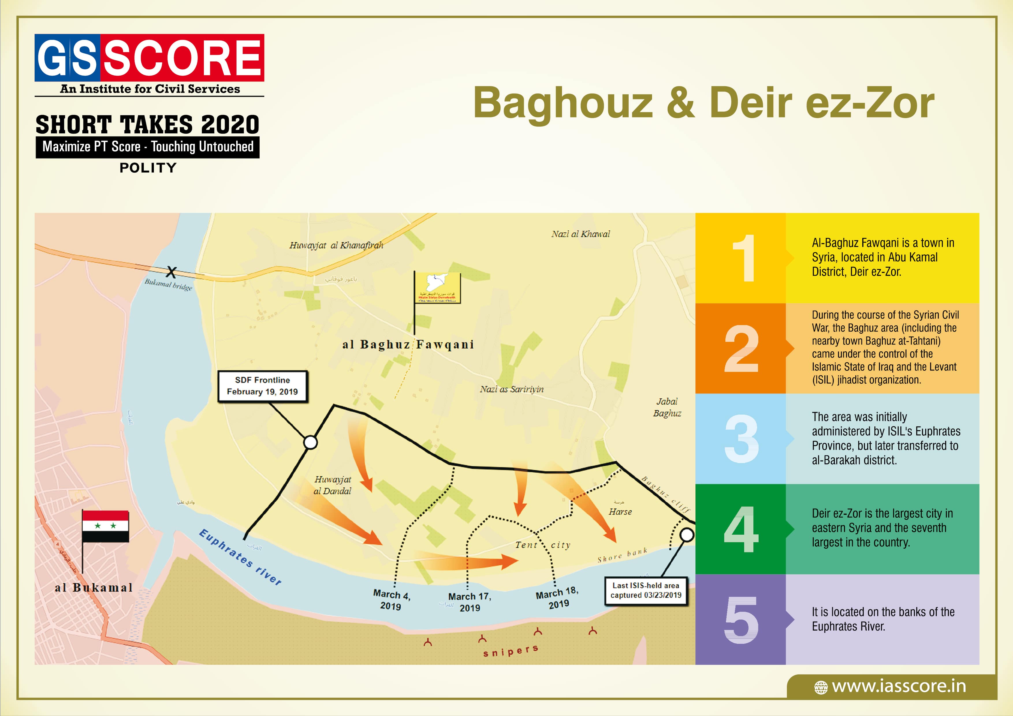
Baghouz And Deir ez-Zor