Geography: Climate of India
Climate of India
Weather is the momentary state of the atmosphere while climate refers to the average of the weather conditions over a longer period of time. India has hot monsoonal climate which is the prevalent climate in south and Southeast Asia. The monsoon regime emphasizes the unity of India with the rest of Southeast Asian region.
Factors determining the climate of India
India’s climate is controlled by a number of factors which are explained below:
Factors related to Location and Relief
- Latitude: The Tropic of Cancer passes through the central part of India in east-west direction. Thus, northern part of the India lies in sub-tropical and temperate zone and the part lying south of the Tropic of Cancer falls in the tropical zone. The tropical zone being nearer to the equator, experiences high temperatures throughout the year with small daily and annual range. Area north of the Tropic of Cancer being away from the equator, experiences extreme climate with high daily and annual range of temperature.
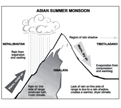
- The Himalayan Mountains: The lofty Himalayas in the north along with its extensions act as an effective climatic divide. The towering mountain chain provides an invincible shield to protect the subcontinent from the cold northern winds. These cold and chilly winds originate near the Arctic Circle and blow across central and eastern Asia. The Himalayas also trap the monsoon winds, forcing them to shed their moisture within the subcontinent.
- Distribution of Land and Water: India is flanked by the Indian Ocean on three sides in the south and girdled by a high and continuous mountain-wall in the north. As compared to the landmass, water heats up or cools down slowly. This differential heating of land and sea creates different air pressure zones in different seasons in and around the Indian subcontinent. Difference in air pressure causes reversal in the direction of monsoon winds.
- Distance from the Sea: With a long coastline, large coastal areas have an equable climate. Areas in the interior of India are far away from the moderating influence of the sea. Such areas have extremes of climate. That is why; the people of Mumbai and the Konkan coast have hardly any idea of extremes of temperature and the seasonal rhythm of weather. On the other hand, the seasonal contrasts in weather at places in the interior of the country such as Delhi, Kanpur and Amritsar affect the entire sphere of life.
- Altitude: Temperature decreases with height. Due to thin air, places in the mountains are cooler than places on the plains. For example, Agra and Darjeeling are located on the same latitude, but temperature of January in Agra is 16°C whereas it is only 4°C in Darjeeling.
- Relief: The physiography or relief of India also affects the temperature, air pressure, direction and speed of wind and the amount and distribution of rainfall. The windward sides of Western Ghats and Assam receive high rainfall during June-September whereas the southern plateau remains dry due to its leeward situation along the Western Ghats.
HIMALAYAN CLIMATE SYSTEM
- India is separated from rest of the Asia by the wall of Himalayan mountain ranges. It restricts the cold and dry winds of Central Asia to the North of Himalayas. These mountain ranges also act as an effective physical barrier for rain bearing southwest monsoon winds and force them to shed their moisture within the country. Thus, it acts as an effective climatic divide between the Indian subcontinent and the central Asia.
- Within the Himalayas, Climate varies depending upon elevation and location. Climate ranges from subtropical in the southern foothills to warm temperate conditions in the middle Himalayas to cold temperate conditions in the higher parts of middle Himalayas to a cold alpine climate at higher elevations.
Seasonal Rhythm
- Winter Season: The temperature in the winter season falls progressively with the increase in altitude from sea level. At the foothill, the temperature in winter is about 18°C in the day time, at the middle Himalayas it is about 6 to 12°C and above this, the temperature is below freezing point. The higher elevations above 5000 meter are permafrost and Tundra type of climate. Dras valley in Kashmir is the coldest place in India. The minimum temperature recorded here on 28th December 1908 was –45°C.
- During the winter season, the westerly jet streams sets in on the south of the Himalayas due to the shift of the ITCZ (Inter Tropical Convergence Zone) southward. These jet streams often bring the low pressure depression created over the Mediterranean Sea to Himalayan region while its journey from Mediterranean Sea to Himalayas, the moisture content gets augmented by Caspian Sea and Persian Gulf. They even reach up to Arunachal Pradesh. Due to orographic upliftment, they cause precipitation in the form of snowfall. After the passage of the disturbance, widespread fog and cold waves set in the region thus lowering the minimum temperature by 5°C to 10°C below the normal average. The range of diurnal temperature increases and winters become more severe. Haze is common in morning and evening. These situations cause great problems to day to day activities. The roads get blocked, commercial setups cannot work due to snow cover creating difficulty, fiights are affected and the people struggle to get everyday requirements and groceries.
- The frequencies of western disturbances vary from year to year but on an average 3 to 5 disturbance per month are experienced. The average precipitation during the three months of winter season i.e. from December to February is about 60cm in the Himalayan region. The eastern Himalayan region also gets rainfall from the north east monsoon. Although it is not so significant as the north east monsoon winds are coming from land and do not have suficient moisture content due to lack of source, but the combined effect of western disturbances and north east monsoon causes an average precipitation of about 50 cm in Sikkim, Arunachal Pradesh and Assam.
Summer Season
- The period from March to June in India is the summer season. This season is mostly dry and hot. At the foothills of Himalayas, the maximum average temperature is about 30°C. Due to the effect of the lapse rate (6.5°C per 1000m of elevation) with altitude, the maximum temperature in the middle Himalayas ranges from 15°C to 25°C, varying in accordance with the altitude, latitude, and other governing factors of temperature. Above the elevation of 5000 m, the temperature is almost below freezing point throughout the year.
- Due to heating of land surface in the area of Chota Nagpur plateau region, a low pressure is created locally which leads to convectional movement of the air. This low pressure depression is carried to the eastern Himalayan region by the westerly jet streams. These air mass further gets cooled adiabatically due to orographic upliftment and causes precipitation in the eastern Himalayan region in the sates of Arunachal Pradesh, Assam, Nagaland, etc. The western disturbances still persist, although, their frequency is reduced. It brings precipitation in the upper reaches of the Himalayas. The weather condition changes abruptly with the arrival of western disturbances. The sky is overcast with clouds. The precipitation is in the form of snowfall and sleet. This condition persists till early April but can be experienced in May also in the upper reaches. These disturbances move eastward and can cause snowfall and thunderstorms in central and eastern Himalayas also till the end of April.
- The diurnal temperature range gradually reduces and is in the range of 11°C to 16°C varying with altitude, distance from sea, wind direction and other governing factors.
Rainy Season
- This season is also called as monsoon season as it starts with the onset of northwest monsoon in India. The monsoon season in India generally starts in last week of May and first week of June varying year to year. The weather conditions change. The relative humidity of the atmosphere increases, sky is over cast with clouds, atmospheric temperature increases before the outbreak of monsoon and there may be some spells of pre monsoon showers.
- As the monsoon comes, there is significant fall in the atmospheric temperature ranging from 3°C to 6°C lower than the month of June in the Himalayan region. After this sudden fall in temperature, there is no further fall in temperature throughout the season. However in the month of September, as the monsoon starts to retreat there is an increase in temperature for a short time period. The night temperature is more or less constant while the day temperature fluctuates on day to day basis. The diurnal temperature range is less and varies between 4°C to 6°C due to the greenhouse effect created by the clouds.
- The eastern Himalayas get the monsoonal rain earlier than the western Himalayas due to nearness to the sea and the direction of movement of the Bay of Bengal branch of monsoon wind. Around June 5, the monsoon breaks in eastern Himalayas. From here, due to the barrier effect of the Himalayas and the orientation of the Himalayas, the Bay of Bengal branch moves westerly along the foothills of Himalayas into the Ganga plains.
- The Arabian Sea branch moving on the eastern side of the Aravalis after being defected due to the orientation of Western Ghats meets Bay of Bengal branch at Agra and moves towards Kashmir. The monsoon breaks in the western Himalayan region around 1st of July.
- But in the western Himalayan region, the precipitation is not as intensive as in the eastern region because most of the moisture is lost during journey of the monsoon winds up till here due to precipitation.
- However the Arabian Sea branch brings more precipitation due to its shorter length of journey uptill western Himalayas. Heavy rainfall is caused in the eastern Himalayas, sub Himalayan regions and the southern slopes of Himalayas. This leads to high flooding of the rivers having their catchment areas in Himalayas.
- For eg.: Brahmaputra receives the water of the eastern Himalayas causing floods in the Assam plains, Kosi River receives the water of eastern Nepal Himalayas by Saptakosi catchment area causing floods in Bihar plains, etc. The western Himalayan region receives around 65 cm of average rainfall in the monsoon season, while ? the eastern Himalayas, as explained earlier, experience the precipitation around 200 cm to 410 cm on an average, while on some places, it reaches to as high as 600 cm also.
Cold Season
- The beginning of withdrawal of southwest monsoon marks the start of cold season which continues uptill November after which the winter season starts.
- In the Himalayan region, the monsoon in the western Himalayas reaches the last i.e. in the first week of July and withdraws from their first i.e. in the second week of September, which gives only two and a half month for the monsoonal activity in the western Himalayas. While in the eastern Himalayan region the monsoon strikes in the first week of June and withdraws in second week of October giving a period of four and a quarter of month for monsoonal activity. Added to this, the eastern Himalayas get a good amount of precipitation from north east monsoon also. This is why there is a great regional disparity in the amount of total rainfall and precipitation received among the different regions of the Himalayas.
- In the season with the cession of the monsoon initially the temperature rises in the range of 3°C to 5°C but within a week or two, the temperature starts falling steeply. Within a month and half i.e. from second week of December, the minimum temperature in the Himalayan region falls below the freezing point. The diurnal temperature range increases steeply due to lack of clouds and absorption of latent heat of melting by the ice sheets.
- During this season from the last week of October the western disturbances start to appear and their frequency increase on the monthly basis as the westerly jet stream gets stronger progressively with the southward movement of Sun and the ITCZ. These western disturbances bring snow fall in the upper reaches.
- This season draws huge amount of tourists in the Himalayan region because of the snow cover. It provides them a perfect place for the skiing and other winter sports.
Annual Rainfall
- The areas receiving an annual rainfall of 200 cm and above are termed as areas of very high rainfall.
- The eastern Himalayas receive an annual rainfall of about 200 cm to 400 cm and even up to 400 to 800 cm in few pockets. Almost the whole of Arunachal Pradesh, Sikkim, Assam & Nagaland come under the area of heavy rainfall.
- The areas receiving a rainfall of 100 cm to 200 cm annually come under the zone of high rainfall. The southern parts of Jammu and Kashmir, Himachal Pradesh and Uttarakhand in Western Himalayas and other regions on the southern slopes of western Himalayas come under the zone of high rainfall.
- The areas receiving 50 cm to 100 cm of rainfall comes under the region of low rainfall. The leeward side of the southern Himalayas in Jammu and Kashmir and the valley areas of western Himalayas come under the zone of low rainfall.
- The areas receiving a rainfall of less than 50 cm comes under the zone of very low rainfall. The only area which is receiving less than 50 cm of rainfall in the Himalayan region is the Ladakh region of the state of Jammu and Kashmir. This area does not have the temperature as high as that of tropical and subtropical region that is why Ladakh region is also called as cold desert.
Indian Monsoon
- Monsoon is a seasonal prevailing wind that lasts for several months. The term was first used in English in India, to refer to the big seasonal winds blowing from the Indian Ocean and Arabian Sea in the Southwest bringing heavy rainfall to the area.
- The unique monsoon circulation in the Indian Ocean and associated rainfall over India has a fundamental impact on socio-economic and agricultural development in this densely populated country. The monsoon accounts for 80 per cent of the rainfall in the country.
Factors Affecting Indian Monsoon
1. Tibet Plateau (TP)
- It is the most mountainous in the world, with a mean height that exceeds 4000 m above sea level. The mechanical effect of the plateau has determinative roles upon the formation of a regional climate system in Asia.
- The thermal effect of the plateau may profoundly affect the atmospheric circulation as well because the sensible and latent heat fluxes from TP reach a higher altitude than its surroundings. The atmosphere above TP is heated more strongly than the surrounding atmosphere at the same level.
- The roles of the Tibetan Plateau (TP) upon the transition of precipitation in the South Asian summer monsoon are investigated using a simplified regional climate model. Before the onset of the south Asian monsoon, descending flow in the mid-troposphere, which can be considered as a suppressor against precipitation, prevails over northern India.
- The descending motion gradually weakens and retreats from this region before July, consistent with the northwestward migration of the monsoon rainfall. To examine a hypothesis that the dynamical and thermal effects of TP cause the mid-tropospheric subsidence and its seasonal variation, a series of numerical experiments are conducted using a simplified regional climate model. The mechanical effect of the TP generates robust descending flow over northern India during winter and spring when the zonal westerly flow is relatively strong, but the effect becomes weaker after April as the westerly flow tends to be weaker.
- The thermal effect of the TP, contrastingly, enhances the descending flow over north India in the pre-monsoonal season. The descending flow enhanced by the thermal effect of the TP has a seasonal cycle because the global-scale upper-level westerly changes the energy propagation of the thermal forcing response.
- The subsidence formed by the mechanical and thermal effects of the TP disappears over northern India after the subtropical westerly shifts north of the plateau, the seasonal change of which is in good agreement with that in the re-analysis data. The retreat of the descending flow can be regarded as the withdrawal of the pre-monsoon season and the commencement of the South Asian monsoon. After that, the deep convection, indicating the onset of the Indian summer monsoon, is able to develop over north India in relation to the ocean- atmosphere and land-atmosphere interaction processes. Northwest India is known to be the latest region of summer monsoon onset in south Asia. Thus, the thermal and mechanical forcing of the TP has great impact on the transition of the Indian monsoon rainfall by changing the mid-troposphere circulation.
- Recently it has been found that there is a positive correlation between Tibetan snow cover and Indian summer monsoon rainfall (IMR). The seasonal monsoon wind shift and weather associated with the heating and cooling of the Tibetan plateau is the strongest such monsoon on earth.
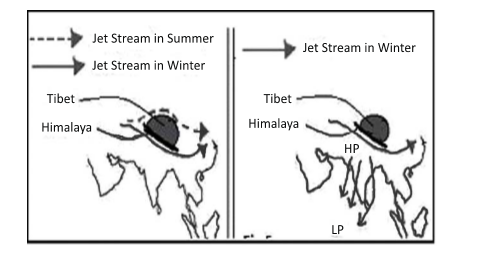
2. Jet Stream Theory
- This theory tries to explain the establishment of both the NE and SW Monsoons as well their unique features like bursting and variability. The jet streams are a system of upper-air westerlies. It gives rise to slowly moving upper-air waves, with 250 knots winds in some air streams.
- Over India, a subtropical westerly jet develops in the winter season which is replaced by the tropical easterly jet in the summer season. The high temperature over the Tibetan Plateau, as well as over Central Asia in general, during the summer is believed to be the critical factor leading to the formation of the tropical easterly jet over India in summer. The mechanism affecting monsoon is that the westerly jet causes high pressure over northern parts of the subcontinent during the winter. This results in the north to south flow of the winds in the form of the NE Monsoon. With the northwards shift of the vertical sun, this jet shifts northwards too. The intense heat over the Tibetan Plateau, coupled with associated terrain features of high altitude of the plateau, etc. generate the tropical easterly jet over Central India. This jet creates a low pressure zone over the northern Indian plains influencing the wind flow towards these plains, assisting the establishment of the SW Monsoon.
3. Tropical easterly jet
- Due to low pressure over Tibetan plateau, high pressure exists in upper troposphere. Due to high pressure, tropical easterly jet stream blow from Tibetan plateau to Mascrene high (low pressure at troposphere) near Madagascar. This helps in sudden onset of monsoon.
4. Subtropical westerly jet stream
- Subtropical westerly jet stream flows entirely south of Himalayas over north India. (during winter). They form depressions and high pressure over northern India.
5. Somali current and Somali jet stream (Phinlander jet)
- During June-July-August due to creation of high pressure at Mascrene high basin, air diverges due to which it goes towards horn of Africa. Here it is divided into two parts - one goes towards Africa and another goes towards Indian subcontinent.]
- It is a low level jet stream (appear only in summer)
- Its occurrence predicts good monsoon in India.
- Somali jet Stream is a low level jet stream which flows from Somalia to Indian mainland
6. Shifting of ITCZ to Tibetan Plateau
- Inter Tropical Covergence Zone (ITCZ) is a zone of low-pressure system which lies at equator normally. But during summer in Northern hemisphere, due to intense heating of Tibetan Plateau, a low pressure system is developed and ITCZ shifts to Tibet Plateau. This causes a thermally induced condition to attract southwest monsoon towards Indian sub-continent.
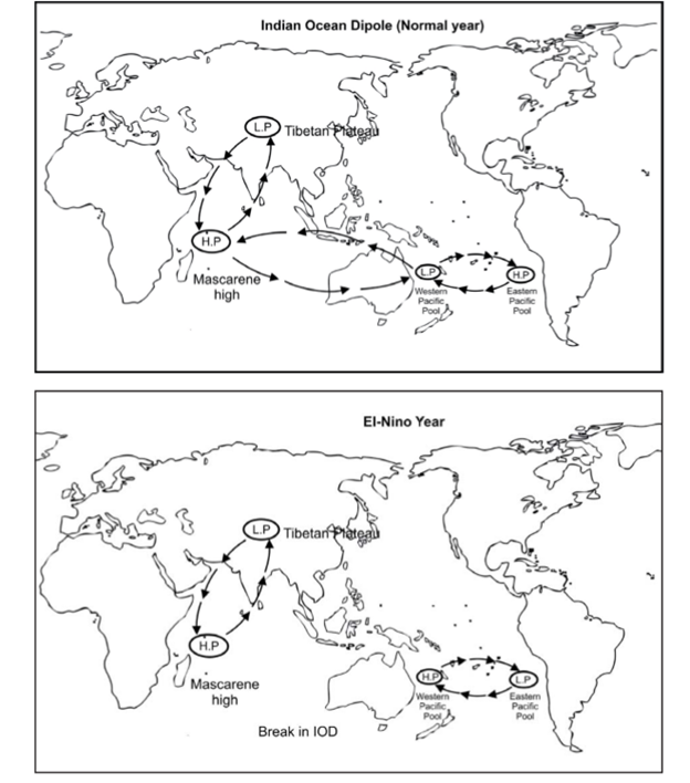
7. Indian Ocean dipole
- Two poles are formed as :
- Mascrence high basin & Tibetan plateau
- Mascrene high basin & Western pacific pool
- When strong low pressure is created over western pacific pool then more winds will flow towards Mascrene high basin and more will be the flow of winds towards low pressure Tibetan plateau. (Sign of good monsoon) this dipole like situation in Indian ocean is called IOD (Indian Ocean Dipole)
- EI-Nino - Due to impact of EI-Nino, western pacific pool becomes high pressure (due to reversal of walker cell) and low pressure system develops at Peruvian coast dipole system is destroyed and hence no wind blow from western pacific pool towards Mascrene high and hence Indian monsoon is impacted.
- Due to unusual heating of Peruvian current at western margin L.P system does not develop in east Australian coast which causes break in dipole. Instead, a new system is emerged by H.P at west Pacific Ocean.
Theory of Bursting Monsoon
The unique feature of bursting of the Monsoon is primarily explained by the Jet Stream theory and the Dynamic Theory.
Dynamic Theory
- According to this theory, during the summer months of Northern Hemisphere, the ITCZ shifts northwards pulling the SW Monsoon winds onto the land from the sea. However the huge landmass of the Himalayas continues to restrict the low pressure zone onto the Himalayas itself. It is only when the Tibetan Plateau heats up a lot more than the Himalayas does the ITCZ abruptly and swiftly shift northwards leading to burst of Monsoon showers over the Indian subcontinent. The reverse shift takes place for the NE Monsoon winds leading to a second minor burst during the Northern Hemisphere winter Months of NE Monsoon rainfall over Eastern Indian peninsula.
Jet Stream Theory
- According to the theory the onset of SW Monsoon over Indian subcontinent is driven by the shift of the subtropical westerly jet northwards from over the plains of India towards the Tibetan Plateau. This shift is due to the intense heating of the Plateau during the summer months. This shift of the westerly jet to the north of the Himalayas is not a slow and gradual process, as expected for most changes in weather pattern. The primary cause of these is believed to be the height of the Himalayas. As the Tibetan Plateau heats up the low pressure created over it pulls the westerly jet northwards. Due to lofty Himalayas, the westerly jet is inhibited from moving northwards. However, with continuous dropping pressure, suficient force is created for the movement of the westerly jet across the Himalayas after a significant period. As such, the shift of the jet is sudden and abrupt causing the bursting of SW Monsoon rains onto the Indian plains. The reverse shift happens for the NE Monsoon.
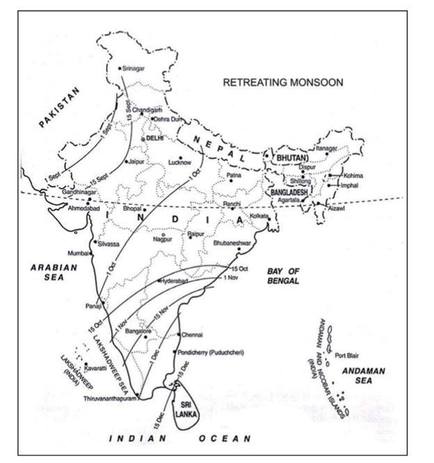
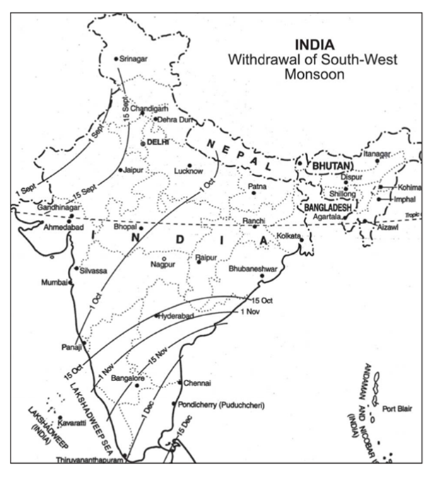
Retreating Monsoon
- This season starts, when monsoon after drenching all of India, begins to retreat. By late September and early October the circulation pattern near the Himalayas returns to its winter regime. The low pressure centre in the northwestern part of India appears to be broken up. Now, the low pressure centre becomes weaker and weaker, and ultimately shifts to the equatorial region. The monsoons begin to retreat.
- Rainfall is the criterion adopted by the Meteorological Department of India for fixing the dates of onset and withdrawal of southwest monsoon over different parts of India. The Department chooses the middle dates of the five-day periods during which the characteristic rise or fall occurs in average rainfall.
- By the end of September the rainfall starts decreasing in the northern plain of India until it ceases by the month of October. However, in the southern part of Indian Peninsula it continues to rain until the middle of December. It may be pointed out that, unlike the sudden burst of monsoon, the retreat of monsoon is gradual. Now, the anti-cyclonic conditions take the place of cyclonic conditions in the northern plain. The monsoon retreats to the south giving place to cold and dry winds of winter monsoon. By about September 15, the monsoon withdraws from the Punjab. The approximate dates of the retreat of monsoon from Uttar Pradesh and Bengal are October 1 and October 15 respectively. The earlier retreat of southwest monsoon is always viewed with great concern, for it dries up the standing crops which need a continuance of rainfall.
- It is well to remember that the retreating southwest monsoons give rainfall to Karnataka in the months of October and November. Madras receives about 55 cm of rainfall in the months of October and November by these winds coming from the northern margin of cyclonic circulation. At this period some depressions develop over the Bay of Bengal and the Arabian Sea. Sometimes they attain the hurricane intensity and produce occasional heavy rain and strong winds. Thus, winter precipitation of Southern India is due to the retreating southwest monsoon.
Seasonal Rhythm of Monsoon in Peninsular India
The Cold Weather Season or Winter Season
- The southern peninsula has rather warm condition and does not have distinctly defined winter weather. The isotherm of 20ºC runs in east-west direction roughly parallel to the tropic of cancer and divides India climatically in the northern and southern parts. In the peninsula temperatures are invariably above 20ºC. In the extreme south the temperature may be well above 25ºC.
- The pressure is comparatively lower in south India. The isobar of 1013mb touches the southern tip of India. The wind starts blowing in the direction of North West to south east. However the wind velocity is low due to low pressure gradient.
- The retreating winter monsoon picks moisture while crossing Bay of Bengal and causes Winter rainfall in Tamil Nadu and south Andhra Pradesh, south east Karnataka and south- east Kerala. The highest seasonal rainfall of about 75cm between October and December occurs along the south- eastern coast of Tamil Nadu and adjoining parts of south Andhra Pradesh
The Summer Season
- The period from March to June is called the summer season.Sometimes also referred to as pre monsoon period. As the season advances, sun’s vertical rays move northwards and large parts of the country including south of Satpura range are heated up. The southern parts are distinctly warmer in March and April. In March, the highest temperatures are nearly 40ºC in the southern parts of the Deccan plateau. Even the night temperature ranges between 20ºC to 25ºC and even 27ºC in the Deccan region.
- However, the maximum summer temperatures are comparatively lower in the southern parts of the country due to moderating effect of sea. The mean maximum temperature at most places is about 26ºC to 30ºC. The temperatures along the West coast are comparatively lower than those prevailing on the east coast due to prevailing westerly winds.
- The pressure difference from north does exceed 3 to 4 MB. The isobar runs more or less parallel to the coast indicating differences in pressure over land and sea. There is marked change in the direction of winds from the winter conditions. The thunderstorms occur in Kerala and adjoining parts of Karnataka and Tamil Nadu, particularly during evening and nights.
- Coastal areas of Kerala and Karnataka receive about 25 cm of rainfall from thunderstorms. These thunderstorms also cause about 10cm of rainfall in the interior of south India. In Tamil Nadu and Andhra Pradesh they are very beneficial to mango crop. In Karnataka they are called cherry blossoms due to their salutary effects on the coffee plantation.
Rainy Season
- The June temperature in south India is 3ºC to 6ºC lower than the May temperature. The temperatures are quite low over the Western Ghats due to high elevation and also due to heavy rainfall, but the rain shadow area is comparatively warmer on account of low elevation and scanty rainfall. The coastal areas of Tamil Nadu and adjoining parts of Andhra Pradesh have temperatures above 30ºC because they receive little rainfall during this season.
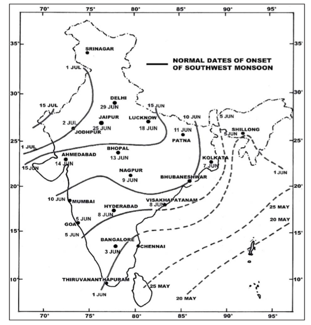
- The atmospheric pressure steadily increases southwards where it ranges between 1008mb and 1010mb. The isobar of 1009mb crosses parts of Kerala and Tamil Nadu. Besides Arabian Sea and the Bay of Bengal the winds blow in a South West to Northeast direction from Arabian Sea and Bay of Bengal. They maintain this direction throughout the peninsular India. The normal date of the arrival of the monsoon is 20th may in Andaman and Nicobar islands.
- The normal date of onset of the South West monsoon over Kerala i.e. the first place of mainland of India is 1st June. The monsoon advances with startling suddenness accompanied with a lot of thunder, lighting and heavy downpour. This sudden onset of rain is termed as monsoon burst. The date of arrival of monsoon on the southern tip is 1st June. Beyond Kerala, the monsoon progresses in two branches viz the Arabian Sea branch and the Bay of Bengal branch. The Arabian Sea branch gradually advances northwards after hitting Malabar Coast and reaches Mumbai by 10th June. While the Bay of Bengal branch hits Meghalaya by 5th of June.
The Season of Retreating Monsoon
- The monsoons withdraw from the peninsula by October and from the extreme South Eastern tip by December. Due to retreat of the monsoon, this season is also called as the Season of retreating monsoon. Unlike the sudden burst of the advancing monsoons, the withdrawal is rather gradual and takes about three months. The temperature decreases to 33ºC in the peninsular and to 30ºC in the Meghalaya Plateau.
- The surface atmospheric pressure is mostly between 1010-1012mb. Consequently the pressure gradient is low.
- This is the season of the most severe and devastating tropical cyclones originating in the Indian seas especially in the Bay of Bengal. The highest frequency of the cyclones is in the month of October and the first half of November.
- Initially they move in a West or North Westerly direction, but many of them later recurve and move towards the Northeast direction. The area that is most vulnerable to these storms includes the coastal belts of Tamil Nadu, Andhra Pradesh and Orissa. They cross the peninsula and enter the Arabian Sea. Some of them again recurve northeast and strike Maharashtra and Gujarat coast.
- October and November is the main rainy season in Tamil Nadu and adjoining areas of Andhra Pradesh to the south of Krishna river delta as well as secondary rainy period for Kerala. The retreating monsoon absorbs moisture while passing over the Bay of Bengal and causes this rainfall.
Climatic Regions of India
- The two most significant factors in defining different climates are temperature and precipitation. A place’s location on a continent, its topography, and its elevation may also have an impact on the climate. Although India has tropical monsoon climate as a whole, there are large regional variations in important climatic elements such as rainfall and temperature. Because of these variations India can be divided in to various climatic regions.
- Koppen’s Classification of Climatic Regions
- Wladimir Koppen gave classification of climate based upon annual and monthly means of temperature and precipitation. It accepts the native vegetation as the best expression of the totality of a climate, so that many of the climatic boundaries are based upon vegetation.
- Koppen has expressed the view that the effectiveness of precipitation in vegetation growth depends not only upon the amount of precipitation, but also upon the intensity of evaporation and transpiration. Much of the water obtained from precipitation is lost from the soil and plants by evaporation and transpiration and is not available for vegetation growth. Thus a certain amount of rain falling in hot and dry climate may not be as useful to vegetation as the same amount of rain falling in a cool and humid climate. Koppen has suggested five major types of climate which correspond with five principal vegetation groups. Each climatic type is represented by a capital letter explained below:
- A: Tropical rainy climate with no cool season. Temperature of the coolest month above 18°C.
- B: Dry climate in which there is an excess of evaporation over precipitation.
- C: Middle-Iatitude rainy climate with mild winters. Average temperature of coldest month below 18°C but above -3°C. Average temperature of warmest month over 10°C.
- D: Middle-latitude rainy climate with severe winters. Average temperature of coldest month below -3°C and that of warmest month above 10°C.
- E: Polar climate with no warm season. Average temperature of the warmest month below 10°C.
- The above mentioned major climatic types are further subdivided depending upon the seasonal distribution of rainfall or degree of dryness or cold. They are designated by small letters a,c,f,h,m,g,s and w each having a specific meaning as per details given below :
- a: hot summer, average temperature of the warmest month over 22°C.
- c: cool summer, average temperature of the warmest month under 22°C.
- f: no dry season.
- w: dry season in winter.
- s: dry season in summer.
- g: Ganges type of annual march of temperature; hottest month comes before the solstice and the summer rainy season.
- h (heiss): average annual temperature under 18°C.
- m (monsoon): short dry season.
- The capital letters S and W are employed to designate the two subdivisions of dry climate: semiarid or Steppe (S) and arid or desert (W). Capital letters T and F are similarly used to designate the two subdivisions of polar climate: tundra (T) and icecap (F).
- Koppen divided India into nine climatic regions making use of the above scheme (Fig.)
- Amw (Monsoon type with short dry winter season). This climate is found in the western coastal region, south of Mumbai. This area receives over 300 cm of annual rainfall in summer from the south-west monsoons.
- As (Monsoon type with dry season in high sun period). This is the region in which rainfall occurs in winter and summer is dry. Coromandel Coast experiences this type of climate. Coastal Tamil Nadu and adjoining areas of Andhra Pradesh are included in it. The amount of rainfall mostly in winter is 75-100 cm and is received from the retreating monsoons.
- Aw (Tropical Savanah type). This climate is found in most parts of the peninsular plateau barring Coromandel and Malabar coastal strips. The northern boundary of this climatic region roughly coincides with the Tropic of Cancer. The average annual rainfall is about 75 cm which is received in summer season from the south west monsoons. Winter season remains dry.
- BShw (Semi-arid Steppe type). Some rain shadow areas of Western Ghats, large part of Rajasthan and contiguous areas of Haryana and Gujarat have this type of climate. Rainfall varies from 12 to 25 cm and most of it occurs in summer. Winter is completely dry. Some arid steppe vegetation is found here.
- BWhw (Hot desert type). ? Most of western Rajasthan has hot desert type of climate where the amount of annual rainfall is less than 12 cm. Temperatures are very high in summer. Natural vegetation is almost absent.
- Cwg (Monsoon type with dry winters).This type of climate is found in most parts of the Ganga Plain, eastern Rajasthan, Assam and in Malwa Plateau. The summer temperature rises to 40°C which falls to 27 °C in winter. Most of rainfall occurs in summer and winter is dry.
- Dfc (Cold, Humid winters type with shorter summer). Some of the north-eastern states such as Sikkim, Arunachal Pradesh and parts of Assam have this type of climate. Winters are cold, humid and of longer duration. The winter temperatures are about 10°C. Summers are short but humid.
- Et (Tundra Type). This climate is found in the mountain areas of Uttarakhand. The average temperature varies from 0 to 10°C. There is fall in temperature with altitude.
- E (Polar Type). The higher areas of Jammu & Kashmir and Himachal Pradesh experience polar climate in which the temperature of the warmest month varies from 0° to 10°C. These areas are covered with snow for most part of the year.
Cyclone Vayu
Context
Cyclone Vayu hit Gujarat and ravaged port town.
About
- Cyclone Vayu is the second deadliest cyclone to hit the state since 1998 that had ravaged port town. It is the strongest cyclone in past 20 years.
What is Cyclone?
- Cyclone forms over different areas and revolve around low-pressure eye. Warm air rises and when it rises, it cools. Cool air cannot hold much moisture and so water gets squeezed out and clouds begins to form.
- If warm air rises quickly it creates updraft. Similarly, if the water in the clouds is build enough then it may fall into the ground in the form of rain and is known as downdraft. When they work together, a storm cell is created. This process continues, the cloud grows and we get a large thunderstorm cloud. These thunderstorm clouds are ready to diversify into other storms like tropical cyclone Vayu and tornadoes.
- Six factors responsible for the formation of cyclone: (1) Sufficient warm temperature at sea surface (2) Atmospheric instability (3) Impact area of Coriolis force so that low pressure can be develop (4) High humidity in the lower to middle levels of the troposphere (5) A pre-existing low-level focus or disturbance (6) Low vertical wind shear.
Impact of Cyclone Vayu on India
- It may cause a significant delay in the arrival of monsoon in some parts of the country.
- Coastal areas in Karnataka, Kerala, Konkan, Goa and Lakshadweep are also expected to receive fairly widespread rainfall.
Cyclone Prone area in India
- According to the meteorological department, there are 13 coastal states and Union Territories in India are Cyclone prone region.
- Four states like West Bengal, Andhra Pradesh, Odisha, Tamil Nadu-and one UT Puducherry on the east coast and Gujarat on the west coast are more vulnerable.
Cyclone Warning System in India
- The India Meteorological Department is the nodal agency, which is responsible for meteorological observations, weather forecasting and seismology.
- A cyclone in the Bay of Bengal is predicted by the Area Cyclone Warning Centres (ACWC) and in the Arabian Sea it is predicted by the Cyclone Warning Centre (CWC).
- Both ACWC and CWC sent their report to National Cyclone Warning Centre (NCWC).
Naming of Tropical Cyclones
- The World Meteorological Organisation (WMO) has devised a mechanism where countries submit a list of names from time to time. Names of cyclones are chosen from this pool. The practice of naming these tropical cyclones in the Bay and Arabian Sea began in September 2004.
- For tropical cyclones developing in the North Indian Ocean, countries like India, Sri Lanka, Bangladesh, Maldives, Myanmar, Oman, Pakistan and Thailand send their names to the Regional Tropical Cyclone Committee.
- At present, all eight countries have submitted eight names each for naming future cyclones. The name Vayu was chosen from this list containing 64 names and was suggested by India.
- As per the existing list, the next cyclone that forms over the Indian Ocean will be named Hikka (Maldives), followed by Kyarr (Myanmar), Maha (Oman), Bulbul (Pakistan), Pawan (Sri Lanka) and Amphan (Thailand). Once the list is exhausted, the committee would meet again and a fresh list will be prepared by the Regional Specialized Meteorological Centre (SMC).
Local Indian Ocean phenomenon may bring better rainfall despite El Nino
Context
The dreaded El Nino is likely to be neutralised by a local phenomenon in the Indian Ocean, which can lead to good rainfall in the June-September season.
About
El Nino:
- El Nino refers to the warming of the equatorial Pacific, which weakens the flow of wind and consequently the monsoon system. In some other parts of the world, it leads to heavy rainfall but in India it weakens rain.
- In this phenomenon, sea-surface temperatures rise over a threshold of +0.5 degree Celsius (and cools by the same margin during La Nina).
- There are a few other key atmospheric indices which one comes across while tracking El Nino. For instance, the Southern Oscillation Index (SOI) that gives an indication of the development and intensity of El Nino or La Nina. The SOI is calculated on the basis of the atmospheric pressure differences between Tahiti (South Pacific Ocean) and Darwin (Australia). Sustained positive SOI values are indicative of La Nina conditions while negative values suggest El Nino conditions.
- Another atmospheric index is the ENSO (El Nino Southern Oscillation) which refers to the oscillation between the El Nino and the La Nina. ENSO shifts irregularly back and forth between El Nino and La Nina every two to seven years.
- Each phase led to disruptions of temperature, precipitation and winds.
- The warmer area of the ocean is also a source for convection and is associated with cloudiness and rainfall.
Indian Ocean Dipole (IOD)
- The phenomenon called Indian Ocean Dipole (IOD) refers to the temperature difference between the eastern and western parts of the water body.
- The negative impact of weak El Nino will be compensated by positive Indian Ocean Dipole. El Nino phenomenon is getting weak and IOD is moving from neutral to positive. This will help rains in the country. The monsoon would be near normal.
What lies ahead?
- El Nino has been generally known to suppress monsoon rainfall in India while La Nina increases it. El Nino years tend to be drier than average, but one of the strongest El Nino of the century (1997-98) produced a monsoon season with above-average rainfall for India.
- Anomalous warming in the Central and East Pacific could have a more profound adverse impact on the monsoon than when the warming shifts to the adjoining Far East Pacific.
- Last but not the least is the ‘dipole’ effect, wherein the Indian Ocean mimics El Nino-La Nina in which the western and eastern basins warm up relative to each other every few years with associated impact on the monsoon. Warming up of the West Indian Ocean boosts a prevailing monsoon, and vice-versa. International and domestic weather agencies expect that this year, the Indian Ocean dipole could be either ‘neutral’ or weakly positive.
Zoji La pass
Context
- The 434-km strategic Srinagar-Leh National Highway, connecting the Kashmir Valley with the Ladakh region, was thrown open for traffic after being closed due to heavy snowfall.
- Zoji La Pass, connects the picturesque Kashmir Valley with the cold Indus valley desert through this 434-km long Srinagar-Leh road. Border Road Organisation is involved in the snow clearance operation.
About
Zoji La pass:
- It is a high mountain pass in Jammu and Kashmir, located on National Highway 1 connecting Srinagar in Kashmir Valley to Leh in Ladakh region.
- It runs at an elevation of approximately 3,528 metres (11,575 ft), and is the second highest pass after Fotu La on the Srinagar-Leh National Highway.
- Every year due to heavy snowfall, vehicle flow stops for 4 months during winter from December to April.
- During the Indo-Pakistani War of 1947, it was seized by Pakistani supported invaders in 1948 in their campaign to capture Ladakh. The pass was re-captured by Indian forces on 1 November in an assault codenamed Operation Bison, which achieved success primarily due to the surprise use of tanks, then the highest altitude at which tanks had operated in combat in the world.
Zoji La Tunnel:
- It is a 14.2 km long road tunnel under Zoji La pass on the Himalayas between Sonmarg and Dras town of Kargil district of Jammu and Kashmir. It is currently under construction.
- The project was approved by the government of India in January 2018 and the construction commenced from May 2018. The construction period is 5 years.
- The tunnel along with 6.5 km long Z-Morh Tunnel, (which is 22 km before Zoji La tunnel towards Srinagar) will ensure year-long road connectivity between Srinagar and Leh which currently remains closed for about 4 months due to heavy snowfall on the Zoji La pass.
- It takes more than 3 hours to cross the pass but the tunnel will reduce the time to only 15 minutes. This tunnel was a strategic requirement of the army and the Ladakhi people as the pass is close to LOC and vulnerable to hostile actions by terrorists.
- Once built, this will be the longest bi-directional road tunnel in Asia.
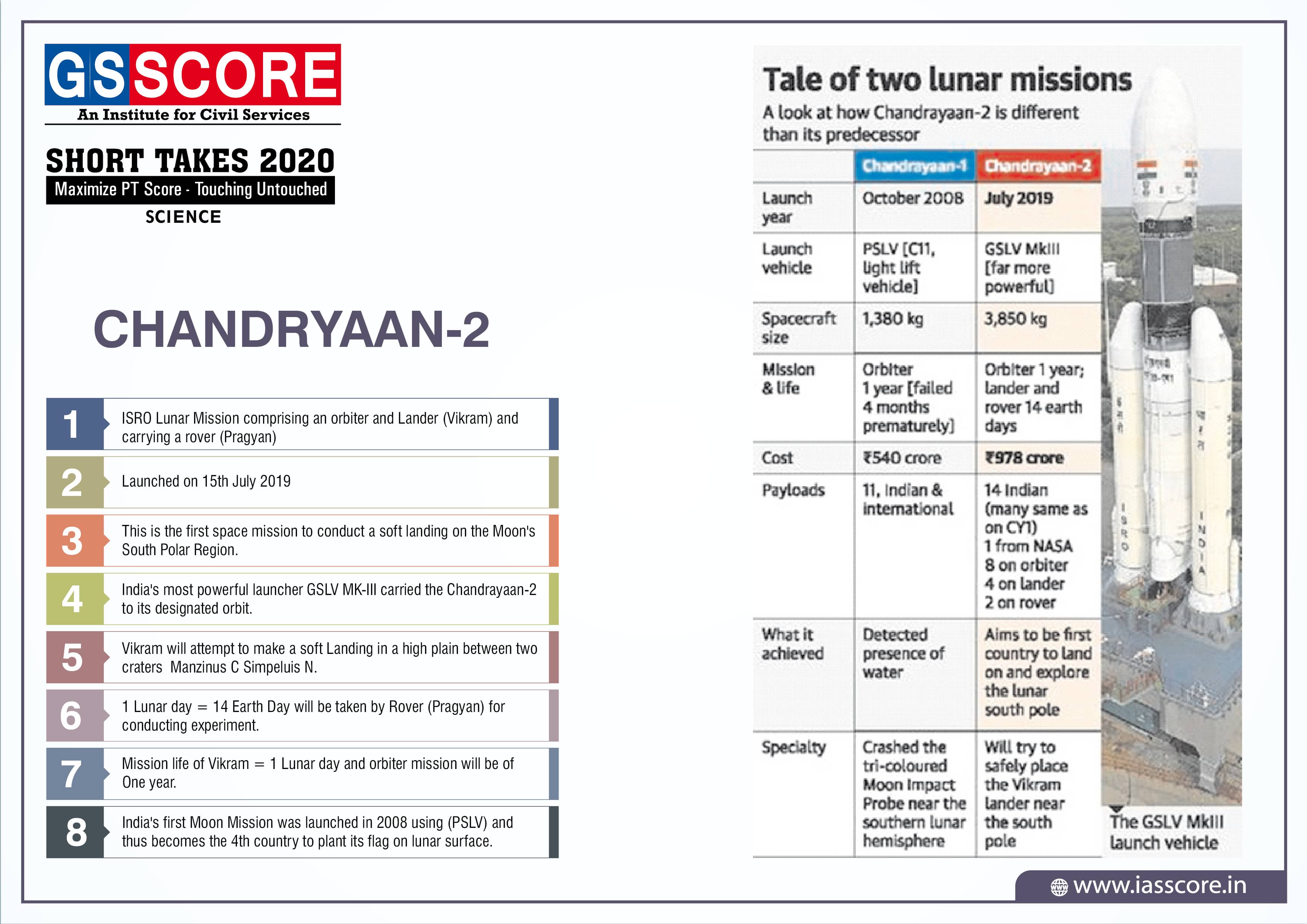
CHANDRYAAN-2
Japanese Encephalitis

Dark Matter

Gravity-RAT

INS Shivalik and INS Sindhukirti