Geography: Climatology Part II
Pre-Conception and Pre-Natal Diagnostic Techniques Act, 1994

Education Quality Upgradation and Inclusion Programme (EQUIP)

Women in Business and Management: The business case for change

Protection of Plant Varieties and Farmers' Rights Act, 2001

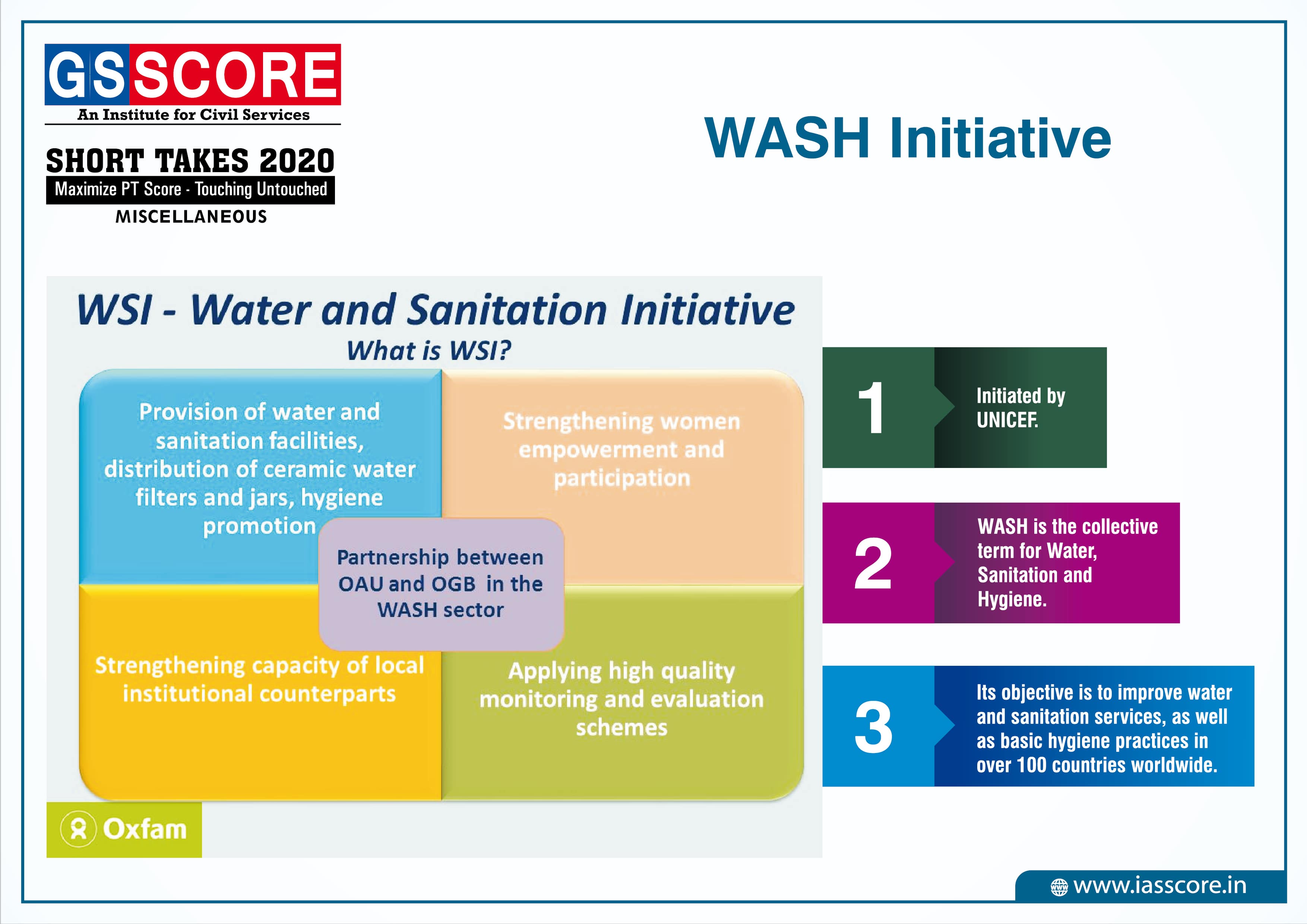
WASH Initiative
ATMOSPHERIC CIRCULATION & WEATHER SYSTEMS
Atmospheric Pressure
The weight of a column of air contained in a unit area from the mean sea level to the top of the atmosphere is called the atmospheric pressure. The atmospheric pressure is expressed in units of millibar. At sea level the average atmospheric pressure is 1,013.2 millibar. Due to gravity the air at the surface is denser and hence has higher pressure.
The distribution of atmospheric pressure over the globe is known as horizontal distribution of pressure. It is shown on maps with the help of isobars. The horizontal distribution of atmospheric pressure is not uniform in the world. It varies from time to time at a given place; it varies from place to place over short distances.
The factors responsible for variation in the horizontal distribution of pressure are as follows:
- Air Temperature: The earth is not heated uniformly because of unequal distribution of insolation, differential heating and cooling of land and water surfaces. Generally there is an inverse relationship between air temperature and air pressure. The higher the air temperature, the lower is the air pressure. In polar region, cold air is very dense hence it descends and pressure increases. From this we might expect, a gradual increase in average temperature towards equator.
- The Earth’s Rotation: The earth’s rotation generates centrifugal force. This results in the defection of air from its original place, causing decrease of pressure. It is believed that the low pressure belts of the sub Polar Regions and the high pressure belts of the sub-tropical regions are created as a result of the earth’s rotation. The earth’s rotation also causes convergence and divergence of moving air.
- Pressure of Water Vapour: In winter the continents are relatively cool and tend to develop high pressure centres; in summer they stay warmer than the oceans and tend to be dominated by low pressure, conversely, the oceans are associated with low pressure in winter and high pressure in summer.
Pressure Belts of the World
- Equatorial Low Pressure Belt: At the Equator heated air rises leaving a low- pressure area at the surface. This low pressure area is known as equatorial low pressure. This area extends between 50N and 50S latitudes. The zone shifts along with the northward or southward movement of sun during summer solstice and winter solstice respectively. The pressure belt is thermally induced because the ground surface gets heated during the day. Thus warm air expands, rises up and creates low pressure.
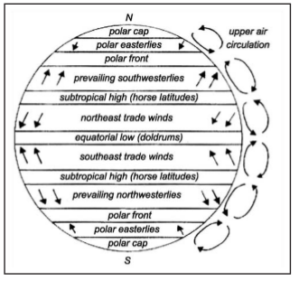
- Sub-tropical High Pressure Belts: The warm air risen up at the equator due to heating reaches the troposphere and bend towards the pole. Due to Coriolis force the air descends at 30-35º latitude thus creates the belt of sub-tropical high pressure. The pressure belt is dynamically induced as it owes its origin to the rotation of the earth and sinking and settling of winds. This zone is characterized by anti-cyclonic conditions which cause atmospheric stability and aridity. Thus, the hot deserts of the world are present in this region extending between 25-35 degree in both the hemisphere.
- Sub-Polar Low Pressure Belt: This belt is located between 60-65 degree latitudes in both the hemisphere. This pressure belt is also dynamically induced. As shown in the figure the surface air spreads outward from this zone due to rotation of the earth thus produces low pressure. The belt is more developed and regular in the southern hemisphere than the northern due to over dominance of water in the former.
- Polar High Pressure Belt: High pressure persists at the pole due to low temperature. Thus the Polar High Pressure Belt is thermally induced as well as dynamically induced as the rotation of earth also plays a minor role.
Winds
- The air is set in motion due to the differences in atmospheric pressure.
- The air in motion is called wind. The wind blows from high pressure to low pressure.
- The wind at the surface experiences friction.
- In addition, rotation of the earth also affects the wind movement.
- The force exerted by the rotation of the earth is known as the Coriolis force.
- Thus, the horizontal winds near the earth surface respond to the combined effect of three forces – the pressure gradient force, the frictional force and the Coriolis force. In addition, the gravitational force acts downward.
Planetary Winds
Planetary winds are major component of the general global circulation of air. These are known as planetary winds because of their prevalence in the global scale throughout the year. Planetary winds occur due to temperature and pressure variance throughout the world.
Trade Wind
- Winds blowing from the subtropical high pressure belt or horse latitudes towards the equatorial low pressure belt of the ITCZ are the trade winds. In the Northern Hemisphere, the trade winds blow from the northeast and are known as the Northeast Trade Winds; in the Southern Hemisphere, the winds blow from the southeast and are called the Southeast Trade Winds.
- The weather conditions throughout the tropical zone remain more or less uniform. This belt is subjected to seasonal variation due to northward and southward movement of sun.
- The equator ward part of the trade wind is humid because they are characterized by atmospheric instability thus causing heavy precipitation.
Westerly Wind
- The Westerlies are the prevailing winds in the middle latitudes between 35º and 65º blowing from the high pressure area in the sub tropical high pressure belt, i.e., horse latitudes towards the sub polar low pressure belt.
- The winds are predominantly from the south-west to north-east in the Northern Hemisphere and from the north- west to southeast in the Southern Hemisphere.
- The Westerlies are strongest in the winter season at times when the pressure is lower over the poles, while they are weakest in the summer season when pressures are higher over the poles.
- The Westerlies are particularly strong, especially in the southern hemisphere, as there is less land in the middle latitudes to obstruct the flow.
Polar Wind
- The winds blowing in the Arctic and the Antarctic latitudes are known as the Polar Winds.
- They have been termed as the ‘Polar Easterlies’, as they blow from the Polar High Pressure belt towards the Sub Polar Low- Pressure Belts.
- In the Northern Hemisphere, they blow in general from the north-east, and are called the North-East Polar Winds; and in the Southern Hemisphere, they blow from the southeast and are called the South-East Polar Winds.
- As these winds blow from the ice- capped landmass, they are extremely cold. They are more regular in the Southern Hemisphere than in the Northern Hemisphere.
Periodic/Seasonal Winds
- The pattern of wind circulation is modified indifferent seasons due to the shifting of regions of maximum heating, pressure and wind belts. This results in seasonal winds. The most pronounced effect of such a shift is noticed in the monsoons, especially over Southeast Asia.
- The word ‘Monsoon’ has been derived from the Arabic word ‘Mausim’ meaning season. The winds that reverse their direction with the change of seasons are called monsoon winds. During summer the monsoon winds blow from sea towards land and during winter from land towards sea.
- Traditionally these winds were explained as land and sea breezes on a large scale. But this explanation does not hold good now. Now a day the monsoon is generally accepted as seasonal modification of the general planetary wind system.
- The Asiatic monsoon is the result of interaction of both planetary wind system and regional factors, both at the surface and in the upper troposphere. India, Pakistan, Bangladesh, Myanmar (Burma), Sri Lanka, the Arabian Sea, the Bay of Bengal, South-east Asia, North Australia, China and Japan are important regions where monsoon winds are prevalent.
Summer Monsoon
During the summer, monsoon winds blow from the cooler ocean surfaces onto the warmer continents. In the summer, the continents become much warmer than the oceans because of a number of factors. These factors include:
- Specific heat differences between land and water.
- Greater evaporation over water surfaces .
- Sub-surface mixing in ocean basins, which redistributes heat energy through a deeper layer.
- Precipitation is normally associated with the summer monsoons. Onshore winds blowing inland from the warm ocean are very high in humidity, and slight cooling of these air masses causes condensation and rain. In some cases, this precipitation can be greatly intensified by orographic uplift. Some highland areas in Asia receive more than 10 meters of rain during the summer months.
Winter Monsoon
- In the winter, the wind patterns reverses, as the ocean surfaces are now warmer. With little solar energy available, the continents begin cooling rapidly as longwave radiation is emitted to space. The ocean surface retains its heat energy longer because of water’s high specific heat and sub-surface mixing. The winter monsoons bring clear dry weather and winds that flow from land to sea.
World Monsoonal Climate
- The Asiatic monsoon is the result of a complex climatic interaction between the distribution of land and water, topography, and tropical and mid- latitudinal circulation. In the summer, a low-pressure center forms over northern India and northern Southeast Asia because of higher levels of received solar insolation.
- Warm moist air is drawn into the thermal lows from air masses over the Indian Ocean. Summer heating also causes the development of a strong latitudinal pressure gradient and the development of an easterly jet stream at an altitude of about 15 kilometers at the latitude of 25° north. The jet stream enhances rainfall in Southeast Asia, in the Arabian Sea, and in South Africa. When autumn returns to Asia the thermal extremes between land and ocean decrease and the westerlies of the mid-latitudes move in.
- The easterly jet stream is replaced with strong westerly winds in the upper atmosphere. Subsidence from an upper atmosphere cold layer above the Himalayas produces outflow that creates a surface high pressure system that dominates the weather in India and Southeast Asia.
- Besides, Asian continent, monsoon wind systems also exist in Australia, Africa, South America, and North America.
Local Winds
Local winds occur on a small spatial scale, their horizontal dimensions typically several tens to a few hundreds of kilometres. They also tend to be short-lived lasting typically several hours to a day. There are many such winds around the world, some of them cold, some warm, some wet, some dry. There are many hazards associated with the winds.
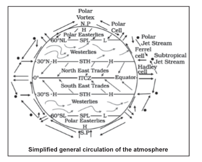
Land and Sea Breezes
- A land breeze is created when the land is cooler than ? the water such as at night and the surface winds have to be very light. When this happens the air over the water slowly begins to rise, as the air begins to rise, the air over the surface of the ocean has to be replaced; this is done by drawing the air from the land over the water, thus creating a sea breeze.
- A sea breeze is created when the surface of the land is heated sufficiently to start air rising. As air rises, it is replaced by air from the sea and creates a sea breeze. Sea breezes tend to be much stronger and can produce gusty winds as the sun can heat the land to very warm temperatures, thereby creating a significant temperature contrast to the water.
Mountain and Valley Winds
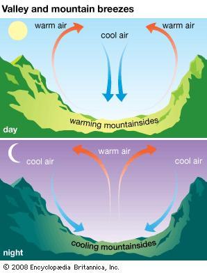
- Mountain-valley breezes are formed by the daily difference of the thermo effect between peaks and valleys. In daytime, the mountainside is directly heated by the sun, the temperature is higher, air expands, air pressure reduces, and therefore air will rise up the mountainside from the valley and generate a valley breeze.
- The valley breeze reaches its maximum force in day time (mostly in afternoon). After this time, the breeze decreases in power and come to a complete stop by sunset. By Sunset, the mountain side region is able to dissipate heat more quickly, due to its higher altitude and therefore temperature drops rapidly. Cold air will then travel down the mountain side from the top and flow into the valley, forming a mountain breeze.
- In daytime, valley breezes carry water vapor to the peak, which will often condense into clouds; these are the commonly seen peak and fag clouds. When the mountain breeze travels down and gathers in the valleys, water vapor will condense. Therefore in valley or basin regions, there are usually clouds and fog before sunrise. During late spring or early autumn, the cold air trapped in the valley and basin will often generate frost.
Regional winds
- Hot winds - Loo, Foehn and Chinook are important hot winds of local category.
- The Foehn is a warm, dry, gusty wind which occurs over the lower slopes on the lee side (the side which is not directly exposed to wind and weather) of a mountain barrier. It is a result of forcing stable air over a mountain barrier. The onset of a Foehn is generally sudden. For example, the temperature may rise more than 10°C in five minutes and the wind strength increase from almost calm to gale force just as quickly. Foehn winds occur quite often in the Alps (where the name foehn originated) and in the Rockies (where the name Chinook is used).
- The local cold winds originate in the snow-capped mountains during winter and move down from the slopes towards the valleys. They are known by different names in different areas.
Air Mass
- An air mass is an extensive portion of the atmosphere having uniform characteristics of temperature, pressure and moisture which are relatively homogeneous horizontally.
- Air masses form over large surfaces with uniform temperatures and humidity, called source regions. Low wind speeds let air remain stationary long enough to take on the features of the source region, such as heat or cold. When winds move air masses, they carry their weather conditions (heat or cold, dry or moist) from the source region to a new region. When the air mass reaches a new region, it might clash with another air mass that has a different temperature and humidity.
- The major source regions of the air masses are the high latitude polar or low latitude tropical regions having such homogeneous conditions. Air masses, therefore, are of two kinds-polar and tropical air masses. Polar air mass is cold and tropical air mass is warm.
- When cold air mass and warm air mass blow against each other, the boundary line of convergence separating the two air masses is termed as front. When the warm air mass, moves upward over the cold air mass the front formed in such a situation is called warm front. On the contrary, when the cold air mass advances faster and undercuts the warm air mass and forces the warm air upwards, the front so formed is called cold front.
- The frontal surface of cold front is steeper than that of a warm front. A prevailing air mass in any region - polar, tropical, maritime or continental largely controls the regions general weather.
- Air masses are named according to their source region. Polar (P) air masses form at high latitudes toward Earth’s poles. Air masses that form at low latitudes are Tropical (T) air masses. The terms Polar and tropical describe the temperature characteristics of an air mass. Polar air masses are cold, while tropical air masses are warm. In addition to their overall temperature, air masses are classified according to the surface over which they form.
- Continental (c) air masses form over land. Maritime (m) air masses form over water. The terms continental and maritime describe the moisture characteristics of the air mass. Continental air masses are likely to be dry. Maritime air masses are humid. Using this classification scheme, there are four basic types of air masses. A Continental Polar (cP) air mass is dry and cool. A Continental Tropical (cT) air mass is dry and warm or hot. Maritime Polar (mP) and Maritime Tropical (mT) air masses both form over water. But a Maritime Polar air mass is much colder than a Maritime Tropical air mass.
Fronts
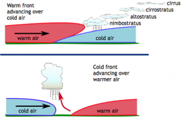
- When cold air mass and warm air mass blow against each other, the boundary line of convergence separating the two air masses is termed as front. At the boundary, or front, there is a marked drop in temperature, increase in humidity, sudden wind change and a marked pressure rise. This marked discontinuity lends support to the theory of two separate air masses with the front being the boundary between the two.
- When the warm air mass, moves upward over the cold air mass the front formed in such a situation is called warm front. On the contrary, when the cold air mass advances faster and undercuts the warm air mass and forces the warm air upwards, the front so formed is called cold front. The frontal surface of cold front is steeper than that of a warm front.
High Pressure and Low Pressure Systems
The pressure differences cause air to move in ways that may make a high or low become the centre of a whole system of weather. At a high-pressure centre, air sinks slowly down. As the air nears the ground, it spreads out toward areas of lower pressure.
- In the Northern Hemisphere, the Coriolis effect makes the air turn clockwise as it moves outward. Most high-pressure systems are large and change slowly. When a high-pressure system stays in one location for a long time, an air mass may form. The air-and resulting air mass-can be warm or cold, moist or dry.
- A high-pressure system generally brings clear skies and calm air or gentle breezes. This is because as air sinks to lower altitudes, it warms up a little bit. Water droplets evaporate, so clouds often disappear.
- A small area of low pressure can also develop into a larger system. It begins as air moves around and inward toward the lowest pressure and then up to higher altitudes. The upward motion of the air lowers the air pressure further, and so the air moves faster.
- The pattern of motion strengthens into a low- pressure weather system. The rising air produces stormy weather. In the Northern Hemisphere, the air in a low-pressure system circles in a counter clockwise direction.
- A low-pressure system can develop wherever there is a centre of low pressure. One place this often happens is along a boundary between a warm air mass and a cold air mass.
Cyclones
Typically, cyclones are elliptical arrangement of isobars having low pressure at the centre with a convergence of winds within them. The wind direction in the cyclones is anti-clockwise in the northern hemisphere and clockwise in the southern hemisphere. Cyclones are of two types - the temperate or mid latitude cyclones and the tropical or low latitude cyclones.
Temperate Cyclones
Temperate cyclones are formed along a front in mid-latitudes between 35°and 65° N and S. They blow from west to east and are more pronounced in winter season.
Polar Front Theory
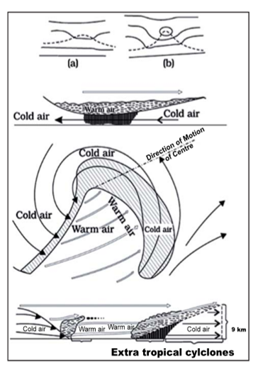
Development and Evolution of a Wave Cyclone, the wave cyclone (often called a frontal wave) develops along the polar front- when a large temperature gradient exists across the polar front - the atmosphere contains a large amount of Available Potential Energy. Instability (kink) forms in the polar front. This instability is the incipient cyclone. A fully-developed “wave cyclone” is seen 1224 hours from its inception. It consists of:
- A warm front moving to the northeast.
- A cold front moving to the southeast.
- Region between warm and cold fronts is the “warm sector”.
- The central low pressure (low, which is deepening with time).
- Overrunning of warm air over the warm front.
- Cold air surging southward behind the cold front.
- Wide-spread of precipitation ahead of the warm front.
- Narrow band of precipitation along the cold front.
- Wind speeds continue to get stronger as the low deepens - the Available Potential Energy (APE) is being converted to Kinetic Energy (KE).
- The production of clouds and precipitation also generates energy for the storm as Latent Heat is released.
- As the cold front moves swiftly eastward,
- The systems start to occlude.
- Storm is most intense at this stage.
- Have an occluded front trailing out from the surface low.
- Triple point/occlusion - is where the cold, warm and occluded fronts all intersect.
- The warm sector diminishes in size as the systems further occlude.
- The storm has used most all of its energy and dissipates.
- The entire APE has been utilized and the KE has dissipated into turbulence- cloud/ precipitation production has diminished.
- The warm sector air has been lifted upward.
- The cold air is at the surface-stable situation
Seasonal Occurrence of Temperate Cyclones
- The temperate cyclones occur mostly in winter, late autumn and spring. They are generally associated with rainstorms and cloudy weather.
- During summer, all the paths of temperate cyclones shift northwards and there are only few temperate cyclones over sub-tropics and the warm temperate zone, although a high concentration of storms occurs over Bering Strait, USA and Russian Arctic and sub-Arctic zone.
Distribution of Temperate Cyclones
- USA and Canada – extend over Sierra Nevada, Colorado, Eastern Canadian Rockies and the Great Lakes region, the belt extending from Iceland to Barents Sea and continuing over Russia and Siberia, winter storms over Baltic Sea, Mediterranean basin extending up to Russia and even up to India in winters (called western disturbances) and the Antarctic frontal zone.
Associated Weather
- The approach of a temperate cyclone is marked by fall in temperature, fall in the mercury level, wind shifts and a halo around the sun and the moon, and a thin veil of cirrus clouds.
- A light drizzle follows which turns into a heavy downpour.
- These conditions change with the arrival of the warm front which halts the fall in mercury level and the rising temperature.
- Rainfall stops and clear weather prevails until the cold front of an anticyclonic character arrives which causes a fall in temperature, brings cloudiness and rainfall with thunder.
- After this, once again clear weather is established. The temperate cyclones experience more rainfall when there is slower movement and a marked difference in rainfall and temperature between the front and rear of the cyclone. These cyclones are generally accompanied by anticyclones.
Tropical Cyclones
Tropical cyclones are intense cyclonic storms that develop over the warm oceans of the tropics. Surface atmospheric pressure in the centre of tropical cyclones tends to be extremely low. Most storms have an average pressure of 950 millibars. To be classified as Tropical cyclones, sustained wind speeds must be greater than 118 kilometers per hour at the storm’s centre.
The main characteristics of tropical cyclones are:
- Have winds that exceed 34 knots (39 mi/hr),
- Blow clockwise in the Southern Hemisphere, and
- Counter-clockwise about their centres in the Northern Hemisphere
Condition for formation of Tropical Cyclones:
- For a cyclone to form several preconditions must be met:
- Warm ocean waters (of at least 26.5°C) throughout a sufficient depth (unknown how deep, but at least on the order of 50 m). Warm waters are necessary to fuel the heat engine of the tropical cyclone.
- An atmosphere which cools fast enough with height (is “unstable” enough) such that it encourages thunderstorm activity. It is the thunderstorm activity which allows the heat stored in the ocean waters to be liberated for the tropical cyclone development.
- Relatively moist layers near the mid- troposphere (5 km). Dry mid levels are not conducive for allowing the continuing development of widespread thunderstorm activity.
- A minimum distance of around 500 km from the equator. Some of the earth’s spin (Coriolis force) is needed to maintain the low pressure of the system. (Systems can form closer to the equator but it’s a rare event)
- A pre-existing disturbance near the surface with sufficient spin (vorticity) and inflow (convergence). Tropical cyclones cannot be generated spontaneously. To develop, they require a weakly organised system with sizeable spin and low level inflow.
- Little change in the wind with height (low vertical wind shear, i.e. less than 40 km/h from surface to tropopause). Large values of wind shear tend to disrupt the organization of the thunderstorms that are important to the inner part of a cyclone.
- Connection between tropical cyclones and wind speed.
Depending on the maximum sustained wind speed, tropical cyclones will be designated as follows:
- It is a tropical depression when the maximum sustained wind speed is less than 63 km/h.
- It is a tropical storm when the maximum sustained wind speed is more than 63 km/h. It is then also given a name.
- Depending on the ocean basins, it is designated either as a hurricane, typhoon, severe tropical cyclone, severe cyclonic storm or tropical cyclone when the maximum sustained wind speed is more than 119 km/h.
- Tropical cyclones can be hundreds of kilometers wide and can bring destructive high winds, torrential rain, storm surge and occasionally tornadoes.
- The impact of a tropical cyclone and the expected damage depend not just on wind speed, but also on factors such as the moving speed, duration of strong wind and accumulated rainfall during and after landfall, sudden change of moving direction and intensity, the structure (e.g. size and intensity) of the tropical cyclone, as well as human response to tropical cyclone disasters.
Structure of the Tropical Cyclone
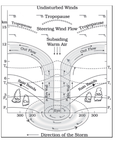
- Tropical cyclones have no fronts associated with them like the mid-latitude cyclones of the polar front. They are also smaller than the mid-latitude cyclone, measuring on average 550 kilometers in diameter. Mature tropical cyclones usually develop a cloud-free eye at their centre.
- In the eye, air is descending creating clear skies. The eye of the tropical cyclones may be 20 to 50 kilometers in diameter. Surrounding the eye are bands of organized thunderstorm clouds formed as warm air move in and up into the storm. The strongest winds and heaviest precipitation are found in the area next to the eye where a vertical wall of thunderstorm clouds develops from the Earth’s surface to the top of the troposphere.
- The circular eye or centre of a tropical cyclone is an area characterised by light winds, fine weather and often clear skies. The eye is the region of lowest surface pressure.
- The eye is surrounded by a dense ring of cloud known as the eye wall. This marks the most dangerous part of the cyclone having the strongest winds and heaviest rainfall.
- Radar and satellite imagery often show that the eye wall clouds are the inner-most coil of a series of spiral rain-band clouds that extend hundreds of kilometres from the centre and typically produce very strong wind squalls. The eye-wall is not always symmetrical, in fact at any one time it is common for the strongest convection and surface winds to be in one part of the eye wall.
Top five longest rivers in the world
About
Following are the top five longest rivers in the world:
- Nile River
- Amazon River
- Yangtze River
- Mississippi River
- Yenisei River
Nile River:
- The River Nile is in Africa. It originates in Burundi, south of the equator, and flows northward through northeastern Africa, eventually flowing through Egypt and finally draining into the Mediterranean Sea.
- It is the main source of water in two countries: Egypt and Sudan.
- The Blue and the White Nile are the two tributaries of the river with the latter having a greater length than the former.
- The source of the White Nile is not yet fully determined but is believed to be somewhere in Burundi or Rwanda. According to some reports, Lake Victoria is considered to be the source of the White Nile which is, in turn, fed by the Kagera River whose two major tributaries are the Ruvyironza and the Nyabarongo rivers of Burundi and Rwanda, respectively.
- The Kagera is formed at the confluence of these two rivers near the Tanzania-Rwanda border.
- The Blue Nile has a more defined origin in Lake Tana in Ethiopia. The two tributaries meet near the Sudanese capital of Khartoum.
- The Nile River’s final course is through Egypt before it forms a delta and drains into the Mediterranean Sea.
- The Nile basin is huge and includes parts of Tanzania, Burundi, Rwanda, Congo (Kinshasa), Kenya.
Amazon River:
- The Amazon River runs 4,000 miles from the Andes to the sea, and is the second longest river in the world.
- It is also the largest in terms of the size of its watershed, the number of tributaries, and the volume of water discharged into the sea.
- The headwaters of the Apurímac River were considered to be the origin of the Amazon River. However, a recent 2014 study claims that the origin of the Amazon can be traced to the Cordillera Rumi Cruz from where Peru’s Mantaro River originates.
- This river then confluences with the Apurímac River (whose headwaters were earlier regarded as the source of the Amazon) and then other tributaries join the river downstream to form the Ucayali River which finally confluences with the Maranon River to form the main stem of the Amazon River.
Yangtze River:
- The Yangtze River is the world’s third longest river and the longest to flow entirely within one country.
- It is also Asia’s longest river.
- The river basin of the Yangtze houses one-third of the population of China.
- Two origins of the Yangtze River have been suggested. Traditionally, the government of China recognizes the Tuotuo tributary located in the Tanggula Mountains as the source of the river.
- According to new data, however, the source of the Yangtze River is located in the Jari Hill from where the headwaters of the Dam Qu tributary originate. These tributaries and more join to form the mighty Yangtze River which finally drains into the East China Sea at Shanghai.
- The Yangze River has over 700 tributaries but the principal tributaries are the Hun, Yalong, Jialing, Min, Tuo Jiang, and Wu Jiang.
Mississippi River:
- The river system comprising of the Mississippi, Missouri, and Jefferson rivers, is regarded as the world’s fourth longest river system.
- The Mississippi River begins in northern Minnesota where Lake Itasca is believed to be the origin of the river and drains into the Gulf of Mexico.
- When we regard the Jefferson River as the furthest source of the Mississippi River, then we get the Mississippi–Missouri–Jefferson river system.
Yenisei River:
- This is the world’s fifth-longest river system and the largest draining into the Arctic Ocean.
- The source of the river is Mungaragiyn-Gol, which is located at the ridge of Dod-Taygasyn-Noor, Mongolia. The Selenge River is regarded as the headwaters of this river system. The Selenge River is 992 km long and drains into Lake Baikal.
- The Angara River rises from Lake Baikal near Listvyanka and flows through the Irkutsk Oblast of Russia and finally joins the Yenisei River near Strelka.
- The Yenisei finally drains into the Kara Sea, Arctic Ocean.
Delayed Withdrawal of Monsoon
Context
The Monsoon season of 2019 officially ended with September, but rainfall has continued in several parts of the country which indicates the delayed withdrawal of Monsoon.
About
Monsoon trends this year:
- After an extremely dry June, which saw a rain deficiency of 33 per cent, the monsoon brought generous rainfall in July, August and September, each subsequent month exceeding the normal by a higher deviation.
- September produced rainfall that was 152 per cent of normal, and this was the second highest rainfall ever recorded in this month. The only higher deviation during September was way back in 1917, when the rainfall was 165 per cent of the then normal for the month.
- August and September together produced 130 per cent of normal rainfall, and this was the highest since 1983. And this was the first time since 1931 that the monsoon ended up producing more than 100 per cent rainfall after having a 30 per cent or more deficiency at the end of the first month.
Why there is late withdrawal of monsoon?
- September marks the beginning of the withdrawal of the monsoon. This year, however, withdrawal has seen a record delay. So far, the longest delay happened in 1961 when the withdrawal started on October 1. According to IMD this year the withdrawal is likely to begin only after October 10.
Reasons:
- Last time September produced so much rain, 1917 which happened to be a La Niña year. This year is not a La Nina year but instead of that the rainfall is higher in September. Though there was no La Niña, a similar phenomenon called the Indian Ocean Dipole, could have contributed to the enhanced rainfall.
- During the monsoon season, the Intertropical Convergence Zone (ITCZ) is located over the Indian subcontinent. By September, as the temperature begins to go down, the ITCZ starts moving southwards of the Indian landmass, towards the equator, and further into the southern hemisphere. This year, this process has not yet started.
- In September this year, the northern hemisphere was much warmer than the southern hemisphere, and that could be one reason why the ITCZ has remained longer than usual over the northern hemisphere which resulted into longer stay of monsoon.
- There was a cooling of the eastern equatorial Indian Ocean, below Sumatra, and that could be one of the reasons for this years extended withdrawal of Monsoon.
What is Indian Ocean Dipole?
- The Indian Ocean Dipole is a phenomenon similar to the ENSO condition observed in the Pacific Ocean which creates the El Niño and La Niña events.
- The sea surface temperatures in the Indian Ocean gets warmer and cooler than normal, and this deviation influences regional atmospheric and weather patterns i.e. The Indian monsoon.
- While the Pacific Ocean only has an El Niño or a La Niña condition at a time, the Indian Ocean experiences both warm and cold conditions at the same time – that’s why known as dipole.
- One of these poles is located in the Arabian Sea while the other is in the Indian Ocean, south of Indonesia.
- The Indian Ocean Dipole is said to be positive when the western pole is warmer than the eastern one and negative when it is cooler.
- The Indian Ocean Dipole and ENSO are not unrelated. Positive Indian Ocean Dipole events are often associated with El Niño and negative Indian Ocean Dipole with La Niña.
- When the Indian Ocean Dipole and ENSO happen at the same time, the Dipole is known to strengthen the impacts of the ENSO condition.
Atlantic Meridional Overturning Circulation (AMOC)
Context
According to scientists weakening of AMOC could have drastic consequences on global climate.
About
What is Atlantic Meridional Overturning Circulation (AMOC)?
- The Atlantic Meridional Overturning Circulation (AMOC) is a large system of ocean currents that carry warm water from the tropics northwards into the North Atlantic.
- AMOC ensures the oceans are continually mixed, and heat and energy are distributed around Earth.
How does the AMOC work?
- The AMOC is a large system of ocean currents, like a conveyor belt, driven by differences in temperature, salt content and the water’s density.
- As warm water flows northwards it cools and some evaporation occurs, which increases the amount of salt. Low temperature and a high salt content make the water denser, and this dense water sinks deep into the ocean.
- The cold, dense water slowly spreads southwards, several kilometres below the surface. Eventually, it gets pulled back to the surface and warms in a process called “upwelling” and the circulation is complete.
Has the AMOC been changing?
- For thousands of years, AMOC has remained stable, but since the past 15 years, it has been weakening which could have dramatic consequences for Europe and other parts of the Atlantic rim.
- Indirect evidence (for example from sediments on the sea floor) shows that there have been some large, rapid changes in the AMOC in the past (for example around the end of the last ice age).
What will be the effect of climate change on the AMOC?
- Climate models suggest that the AMOC will weaken over the 21stCentury as greenhouse gases increase. This is because as the atmosphere warms, the surface ocean beneath it retains more of its heat.
- All these changes make the ocean water lighter and so reduce the sinking in the ‘conveyor belt’, leading to a weaker AMOC. So the AMOC is very likely to weaken, but it’s considered very unlikely that large, rapid changes in the AMOC, as seen in past times, will happen in the 21st
- A weaker AMOC will bring less warm water northwards, and this will partly offset the warming effect of the greenhouse gases over Western Europe.
What is the role of Indian Ocean?
- As the Indian Ocean warms faster and faster, it generates additional precipitation. This draws more air from other parts of the world to the Indian Ocean, including the Atlantic.
- With so much precipitation in the Indian Ocean, there will be less precipitation in the Atlantic Ocean. Less precipitation will lead to higher salinity in the waters of the tropical portion of the Atlantic because there won’t be as much rainwater to dilute it.
- This saltier water in the Atlantic, as it comes north via AMOC, will get cold much quicker than usual and sink faster.