Geography: Drainage System of India
Drainage System of India
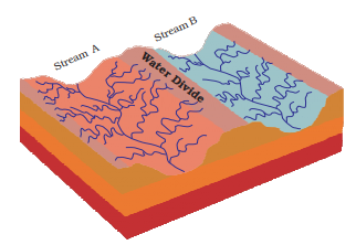
The term drainage describes the river system of an area. The area drained by a single river system is called a drainage basin. A closer observation on a map will indicate that any elevated area, such as a mountain or upland, separates two drainage basins. Such an upland is known as a water divide.
The drainage systems of India are mainly controlled by the broad relief features of the subcontinent. Accordingly, the Indian rivers are divided into two major groups:
- the Himalayan rivers; and
- the Peninsular rivers.
Apart from originating from the two major physiographic regions of India, the Himalayan and the Peninsular Rivers are different from each other in many ways. Most of the Himalayan Rivers are perennial. It means that they have water throughout the year. These rivers receive water from rain as well as from melted snow from the lofty mountains. The two major Himalayan Rivers, the Indus and the Brahmaputra originate from the north of the mountain ranges. They have cut through the mountains making gorges. The Himalayan Rivers have long courses from their source to the sea. They perform intensive erosional activity in their upper courses and carry huge loads of silt and sand. In the middle and the lower courses, these rivers form meanders, oxbow lakes, and many other depositional features in their floodplains. They also have well-developed deltas. A large number of the Peninsular Rivers are seasonal, as their flow is dependent on rainfall. During the dry season, even the large rivers have reduced flow of water in their channels. The Peninsular Rivers have shorter and shallower courses as compared to their Himalayan counterparts. However, some of them originate in the central highlands and flow towards the west. Most of the rivers of peninsular India originate in the Western Ghats and flow towards the Bay of Bengal.
1. HIMALAYAN DRAINAGE SYSTEM
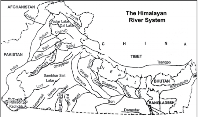
Indus River System
- Indus River is great trans-Himalayan river of South Asia. It is one of the longest rivers in the world, with a length of some 1,800 miles (2,900 km). Its total drainage area is about 450,000 square miles (1,165,000 square km), of which 175,000 square miles (453,000 square km) lie in the Himalayan ranges and foothills and the rest in the semiarid plains of Pakistan.
- The Indus originates in the Kailash range in Tibet near Lake Manasarovar. It follows a north-westerly course through Tibet. It enters Indian Territory in Jammu and Kashmir. It forms a picturesque gorge in this part. Several tributaries - the Zaskar, the Shyok, the Nubra and the Hunza join it in the Kashmir region. It FLows through the regions of Ladakh, Baltistan and Gilgit and runs between the Ladakh Range and the Zaskar Range. It crosses the Himalayas through a 5181 m deep gorge near Attock, lying north of the Nanga Parbat and later takes a bend to the south west direction before entering Pakistan. It has a large number of tributaries in both India and Pakistan and has a total length of about 2880 km from the source to the point near Karachi where it falls into the Arabian Sea. The main tributaries of the Indus in India are Jhelum, Chenab, Ravi, Beas and Sutlej.
- The principal rivers of the Indus River system are snow-fed. Their flow varies greatly at different times of the year: the discharge is at a minimum during the winter months (December to February); there is a rise of water in spring and early summer (March to June); and foods occur in the rainy season (July to September). Occasionally there are devastating flash foods. The Indus and its tributaries receive all their waters in the hilly upper parts of their catchments. Therefore, their flow is at a maximum where they emerge out of the foothills, and little surface flow is added in the plains, where evaporation and seepage considerably reduce the flow volume. On the other hand, some water is added by seepage in the period after the monsoon months. In the main stream of the Indus, the water level is at its lowest from mid December to mid-February. After this the river starts rising, slowly at First and then more rapidly at the end of March. The high-water level usually occurs between mid-July and mid-August. The river then falls rapidly until the beginning of October, when the water level subsides more gradually.
The Ganga River System
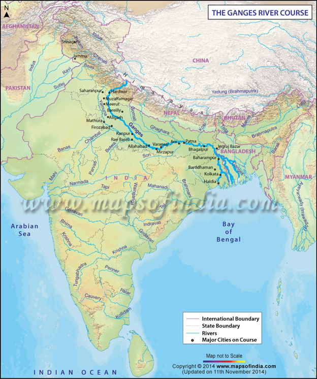
- The Ganga river system consists of the River Ganga and a large number of its tributaries. This system drains a very large area comprising the middle part of the Himalayas in the north, the northern part of the Indian Plateau in the south and the Ganga Plain in-between. The total area of the Ganga basin in India is 861,404 sq. km which accounts for 26.3 per cent of the geographical area of the country. This basin is shared by ten states. These states are Uttaranchal and Uttar Pradesh (34.2%), Madhya Pradesh and Chhattisgarh (23.1%), Bihar and Jharkhand (16.7%), Rajasthan (13.0%), West Bengal (8.3%), Haryana (4.0%) and Himachal Pradesh (0.5%). The Union Territory of Delhi accounts for 0.2% of the total area of the Ganga Basin.
- The Ganga originates as Bhagirathi from the Gangotri glacier in Uttar Kashi District of Uttaranchal at an elevation of 7,010 m. Alakhnanda joins it at Devaprayag. But before Devaprayag, the Pindar, the Mandakini, the Dhauliganga and the Bishenganga rivers pour into the Alaknanda and the Bheling flows into the Bhagirathi. The total length of the Ganga River from its source to its mouth (measured along the Hugli) is 2525 km, of which 310 km in Uttaranchal, 1140 km in Uttar Pradesh, 445 km in Bihar and 520 km in West Bengal. The remaining 110 km stretch of the Ganga forms the boundary between Uttar Pradesh and Bihar.
- Before entering the Bay of Bengal, the Ganga, along with Brahmaputra, forms the largest delta of the world between two arms: the Bhagirathi Hugli and the Padma/Meghna covering an area of 58,752 sq km. The delta front of the Ganga is a highly indented area of about 400 km length extending from the mouth of the Hugli to the mouth of the Meghna. The delta is made of a web of distributaries and islands and is covered by dense forests called the Sunderbans. A major part of the delta is a low- lying swamp which is flooded by marine water during high tide.
Brahmaputra River System
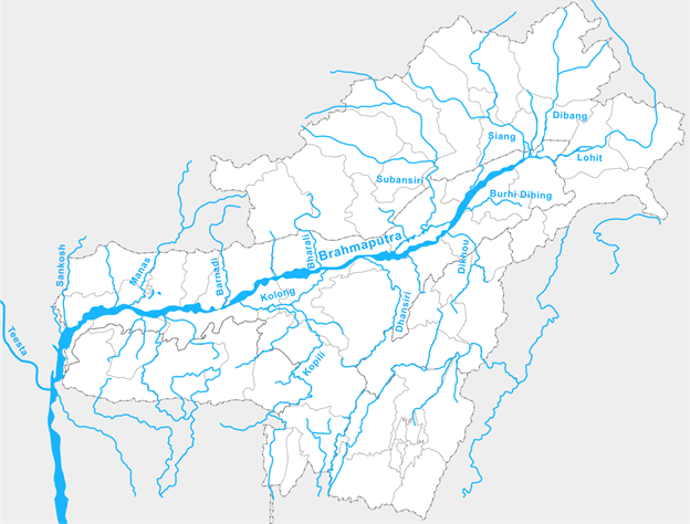
- The river Brahmaputra covers a catchment area of about 5,80,000 Sq.km. right from its origin in Himalayan Lake Manasarover at an elevation of about 5,150 m in Tibet to the outfall in the Bay of Bengal. It flows eastward in Tibet and south, south-west in India and traverses a distance of about 2900 km out of which 1,700 km is in Tibet, 900 km is in India and 300 km is in Bangladesh. In the upper reaches, the river is fed by the glaciers and in the lower reaches, it is joined by a number of tributaries which originates at different elevation in the hills encircling the catchment, forming watershed. Among the tributaries Subansiri, Manas, Jiabharali, Pagladiya, Puthimari and Sankosh, etc are snow fed.
- The Tibetan name of river is “TSANGPO” and Chinese name is “YALUZANGBU”. The watershed area is mostly on the northern side of the river in this region. After traversing a distance of about 1700 km eastwardly, the river changes its course from east to south and then enters the Arunachal Pradesh in Indian Territory. Its name also changes from “TSANGPO” to Siang and Dehang in Arunachal Pradesh. The river then flows almost in Southern direction for another distance of about 200 km upto Passighat. Before touching plains it is joined by two major Himalayan tributaries viz. Lohit and Debang. The combined flow of these rivers is known as the Brahmaputra and passes through the plains of Assam and Bangladesh before falling into the Bay of Bengal. From Passighat to Dhubri where it travels in plains of Assam is well known as Brahmaputra valley.
- The important tributaries of River Brahmaputra are:
- Left bank tributaries: Dhansiri, Kapili, Barak.
- Right bank tributaries: Subansiri, Jia Bhoraeli, Manas, Sankosh, Tista & Raidak
- Dhansiri: Rises from Naga Hills.
- Sankosh: It’s the main river of Bhutan, meets Brahmaputra at Dhubri, Assam.
- Manas: Rises from Tibet and joins Brahmaputra on its right bank.
- Subansiri: It is flows in between the Mikir hills & Abor hills and later joins Brahmaputra on its right bank.
- Tista: Rises from Kanchan-junga, fed by the tributaries like Rangit & Rangpo, it joins the Brahmaputra river in Bangladesh.
- Barak: Rises in Nagaland. It enters Bangladesh as River Surma which falls into River Padma at Chandpur.
2. DRAINAGE SYSTEM OF PENINSULAR INDIA
Origin of Peninsular Drainage
- Subsidence of western flank of peninsula during early tertiary period. It his disturbed the symmetry of peninsular block’s river watershed.
- Upheaval of the Himalayas when the northern flank of peninsular block was subjected to subsidence and consequent trough faulting. The Narmada and Tapi flow in trough faults and fill the original cracks with detritus materials. Hence there is lack of alluvial and deltaic deposits in these rivers.
- Slight tilting of peninsular block from North-West to South-East has caused entire drainage system to flow towards Bay of Bengal.
- Types of Peninsular River System (On the basis of direction of flow)
- West flowing rivers
- East flowing Rivers
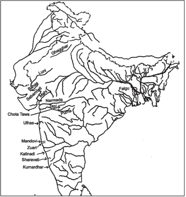
West flowing Rivers
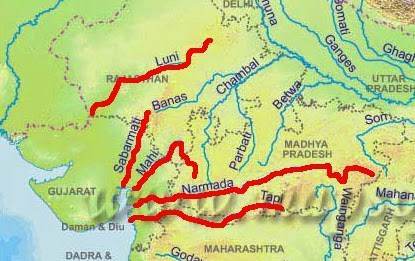
Narmada
- Origin – Amarkantak plateau (1,057m) (Shahdol district, Madhya Pradesh)
- Total Length– 1,310 km (largest west flowing river) Only 112 km navigable from mouth.
- Flows 1,078 km in Madhya Pradesh Forms 32 km long boundary between M.P and Maharashtra.
- Forms 40 km long boundary between Maharashtra & Gujarat Flows 160 km in Gujarat
- Makes an estuary before entering into Gulf of Khambhat.
- There are several islands in estuary formed by Narmada. Aliabet is an important estuary island.
- States – M.P., Maharashtra, Gujarat
- Landmarks – Dhuan Dhar falls also called cloud of mist (30m) located in Jabalpur district, Madhya Pradesh. This fall is located in a Gorge of marble.
- Other falls- Mandhar falls (12m)Dardi fall (12m) Sahasradhara falls (8m)
The Tapi (or Tapti)
- Origin – Betul plateau (M.P) in Satpura Range
- Total length – 730 km (32 km from sea)
- State – M.P, Maharastra & Gujrat
- Meets- Arabian Sea at Gulf of Khambhat
The Sabarmati
- Sabarmati River is formed by confluence of Sabar and Hathmati streams
- Origin – Mewar hills (Aravali range) (Rajasthan)
- Length – 320 km
- Mouth – Gulf of Khambhat
- States – Rajasthan & Gujarat
- Tributaries – The Sedhi, The Harnav, the Vartak, the Wakul, The Meshwa
The Mahi
- Origin – Vindhyas (500 m)
- Meeting point – Gulf of Khambat
- States – Madhya Pradesh, Maharastra & Gujrat
- Length – 533 km
- Tributaries – Som, Anas and Panam
Luni
- Also known as ‘Sagarmati’
- It flows through ‘Thar Desert’
- It has an Inland Drainage as it disappears into Marshy land of Rann of Kutch
- Origin – Aravalli (west of Ajmer, Rajasthan)
- Length – 482 km
- Meeting point – Lost into Marshy land of Rann of Kutch (Inland drainage)
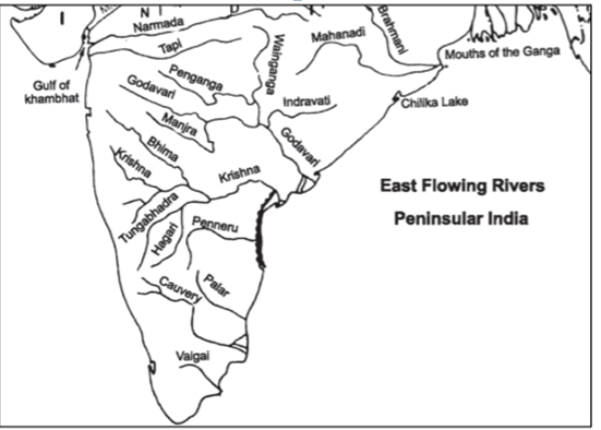
East Flowing Rivers
Damodar
- Origin – Chhotanagpur plateau
- Length – 541 km
- Its joins the Bhagirathi – Hooghly in West Bengal
- Also known as ‘Sorrow of Bengal’
Suvarnrekha
- Origin – Ranchi plateau
- Length – 474 km
- Tributaries –Baitarni & Brahmani
- It flows in States of Jharkhand and Orissa
Mahanadi
- Origin – Dandakaranya (near Sihawa, Raipur, Chhattisgarh)
- Length – 857 km States –
- It flows in Chhattisgarh and Odisha.
- It forms delta of about 9,500 km sq.
Rushikulya River
- Origin – Nayagarh hills (Odhisha)
- Length – 165 km
- States – Its flows in Odisha
- It flows near Chilka lake (largest brackish water lake of Asia)
- Mouth of Rushikulya River is known for mass hatching of olive ridley turtles. This is smallest and most abundant of all sea turtles found in the world.
- Olive Ridley turtles are only found in tropical waters of Pacific, Altantic and Indian Ocean.
Godavari River
- Origin – Trimbak plateau (Nashik, Maharashtra
- Length – 1,465 km States – Maharashtra, Andhra Pradesh, Telangana
- It is second largest river of India and largest river system of Peninsular India
- It is also called Gautami or Virdhha Ganga
Krishna River
- Origin – Western Ghats just north of Mahabaleshwar (Maharashtra)
- Length – 1400 km
- State – Maharashtra, Telangana, Karanatka, Andhra Pradesh
Penneru
- Origin – Nandidurg Peak (Karnatka)
- Length – 597 km
- State – Karnatka and Andhra Pradesh
- Tributaries-Kundur, Charavati, Papagni, Punchu
Kaveri
- Origin – Taal Kaveri (Bramhagiri Range, Western Ghat, near Bengaluru, Karntaka)
- Length – 800 km
- States – Karnatka, Tamil Nadu
- It receives rainfall from both South-West monsoon as well as retreating north-east monsoon due to which it causes food in its lower course during winter.
- One of the most well utilized rivers having 90-95% capacity utilized.
- Forms delta before merging into Bay of Bengal.
- Sivasamudram waterfalls (101 m high) are situated on it.
Vaigai River
- Origin – Varushand hills (near Annamalai hills & Palni hills)
- Length – 258 km
- State – Tamil Nadu
- It is a dry channel which reappears and disappears frequently.
- Madurai is located on Vaigai river
Orchids of India: A Pictorial Guide
Context
- The Botanical Survey of India has published Orchids of India: A Pictorial Guide- the first comprehensive census of orchids of India.
About
Highlights of the survey
- Orchids of India: A Pictorial Guide gives all details of all the species of India, which was unveiled by the Ministry of Environment, Forest and Climate Change.
- According to the publication, the total number of orchid species endemic to India is 388.
- 757 (60%) of all orchids found in India are epiphytic, 447 are terrestrial and 43 are mycoheterotrophic.
- The Himalayas, North-East parts of India and Western Ghats are the hot-spots of orchids.
- The highest number of orchid species is recorded from Arunachal Pradesh followed by Sikkim and West Bengal. The Western Ghats have high endemism of orchids.
- Among the bio geographic zones of India, the Himalayan zone is the richest in terms of orchid species followed by Northeast, Western Ghats, Deccan plateau and Andaman & Nicobar Islands.
- The publication point out that Kerala has 111 of these endemic species while Tamil Nadu has 92 of them.
Orchids
- Orchids have unique shape and ornamentation and have complex floral structure that facilitates biotic cross-pollination
- They are broadly categorised into three life forms: a) epiphytic (plants growing on another plants including those growing on rock boulders and often termed lithophyte), b) terrestrial (plants growing on land and climbers) and c) mycoheterotrophic (plants which derive nutrients from mycorrhizal fungi that are attached to the roots of a vascular plant).
- The epiphytic orchids are abundant up to 1800 m above the sea level and their occurrence decreases with the increase in altitude.
- Terrestrial orchids, which grow directly on soil, are found in large numbers in temperate and alpine region whereas mycoheterotrophic orchids, mostly associated with ectomycorrhizal fungi, are found in temperate regions, or are found growing with parasites in tropical regions.
- The entire orchid family is listed under appendix II of CITES (Convention on International Trade in Endangered Species of Wild Fauna and Flora) and hence any trade of wild orchid is banned globally.
- Some of the orchids like Dendrobium , Phalaenopsis, Oncidium and Cymbidium are quite popular in floriculture trade and have a demand both within and outside country.
Botanical Survey of India (BSI)
- BSI is the apex research organization under the Ministry of Environment and Forests (MOEF) for carrying out taxonomic and floristic studies on wild plant resources of the country.
- Its objective is to undertake intensive floristic surveys and collect accurate and detailed information on the occurrence, distribution, ecology and economic utility of plants in the country.
- It was established in 1890 with objective to explore plant resources of country and to identify plants species with economic virtues.
- It develops National database of Indian plants, including herbarium and live specimens, botanical paintings and illustrations, etc.
CITES
- It is an international agreement between governments aimed to ensure international trade in specimens of wild animals and plants does not threaten their survival.
- By this agreement States and regional economic integration organizations adhere voluntarily. States that have agreed to be bound by the Convention ('joined' CITES) are known as Parties.
- Although, legally binding – in other words they have to implement the Convention – it does not take the place of national laws. Rather it provides a framework to be respected by each Party, which has to adopt its own domestic legislation to ensure that CITES, is implemented at the national level.
How CITES works?
- It works by subjecting international trade in specimens of selected species to certain controls. All import, export, re-exports and introduction from the sea of species covered by the Convention has to be authorized through a licensing system.
- Each Party to the Convention must designate one or more Management Authorities in charge of administering that licensing system and one or more Scientific Authorities to advise them on the effects of trade on the status of the species.
Polavaram Irrigation Project
Context
The Ministry of Jal Shakti has constituted a committee to examine the cost escalation of the Polavaram irrigation project under the instructions of the Ministry of Finance.
About
More on news:
- Revised Cost Committee has been formed to rework the cost of Polavaram Irrigation Project (PIP) in Andhra Pradesh, under the chairmanship of a joint secretary of the Finance Ministry.
- The revised cost estimates is being assessed by the Technical Advisory Committee.
- Ministry of Finance has also asked the state government to soon send an audit of Rs 5,000 crore spent prior to 2014, as an audit of Rs 3,000 crore spent has been held so far.
Compensation to affected people
- Compensation package of Rs. 6,36,000 has been fixed for per affected family and those whose cattle is also affected, they will get another Rs. 25,000, as per the package decided.
- There is no complaint pending with the Government of India. To ensure rehabilitation and resettlement of those affected by the project, committees have been formed by state governments and are headed by collectors to look into grievances. Even, a committee has also been set up under the Secretary of Ministry of Tribal Affairs to redress the grievances of tribal people.
Funding Issue of PIP
- The Government of Andhra Pradesh submitted Revised Cost Estimates (RCE) for Rs 57,297.42 crore at 2017-18 price level to Central Water Commission (CWC) in January, 2018.
- The Advisory Committee on Irrigation, Flood Control & Multipurpose Projects of the Department of Water Resources, River Development & Ganga Rejuvenation, Ministry of Jal Shakti in its 141st meeting held in February, 2019 accepted the RCE of the PIP for Rs 55,548.87 crore at 2017-18 Price level (PL) of which cost of irrigation component is Rs.50,987.96 crore
- The approved RCE has reduced mainly on account of reconciliation in estimated cost of certain land under submergence, land for which compensation is payable, cost of remaining works as per relevant schedule of rates.
Polavaram Irrigation Project (PIP)
- This project is located in West Godavari district of Andhra Pradesh, which will also interlink several rivers in the state.
- It has been accorded national project status by the Centre. Its implementation is monitored by the Central Water Commission.
- The project involves relocation of about 50,000 families especially in Khammam, East Godavari and West Godavari districts in Andhra Pradesh, besides 2,000 families in Odisha and Chhattisgarh.
Aim of the Project
- Purpose of this multi-purpose project is to facilitate irrigation and it will also help in the supply of drinking water to Visakhapatnam and water for industrial purposes.
- It also endeavours hydropower to regions of East Godavari, Vishakhapatnam, Krishna and West Godavari districts of Andhra Pradesh.
- It seeks to address the challenges of flooding and droughts witnessed in the respective basins.
- The project also aims to help the Rayalaseema region (comprising Anantapur, Chittoor, Kadapah and Kurnool districts out of the total 13 districts) get more water.
Issues with the project
- Displacement: The environmental impact assessment (EIA) of the project says 276 villages will be affected. The Polavaram Project Environmental Impact Appraisal Report of 1985 expected 150,697 people to be displaced in 226 villages. Of the displaced population, tribals constitute 50%. With inadequate resettlement and rehabilitation measures, this has severe implications on the socio-economic life of the displaced populations.
- Changes to the ecology of the region: Environmental activists argue that the project will submerge forests, wildlife sanctuaries and as a result disturb the ecology.
- Too costly: The project will heavily burden the exchequer and low-cost alternatives for flood and drought prevention should be explored.
Heat Waves
Context
In early June 2019, an intense heat wave scorched many parts of India which led to the death of 36 people in the country, mostly from Andhra Pradesh.
About
More on News
- In 2019, sparse rainfall during the pre-monsoon season, along with a delayed monsoon, has made the heat more unbearable.
- The NDMA official added that Churu (Rajasthan), where temperature crossed the 50 degrees Celsius mark, has not registered a single death whereas parts of Andhra Pradesh have witnessed most number of deaths, where the temperature was relatively lower.
- Reason behind this Anomaly
- The Comfortable Index of a region increases with the increase in humidity. Comfortable Index measures the human discomfort due to the combined effects of heat and humidity.
- Since humidity in Andhra Pradesh would be 80-90 per cent, it makes the overall comfortable index much more than a person in the state is used to experiencing. This will make people feel that they are experiencing temperatures above 70°Celsius.
This is true about most coastal states like Odisha, Andhra Pradesh and Telangana whereas Churu has humidity around 10 to 15 per cent.
- This happens because it is not just temperature, but humidity also plays a
- Weak El Niño conditions may also play their part in ensuring higher than normal temperature.
Heat Waves
Heat Wave is simply, a continuous spell of abnormally hot weather. Heat wave need not be considered till maximum temperature of a station reaches at least 40º C for Plains and at least 30º C for Hilly regions.
Criteria for declaring Heat Wave followed by IMD
Situation 1 - When normal maximum temperature of a station is less than or equal to 40º C. Declare Heat Wave if:
- Heat Wave Departure from normal is 5º C to 6º C
- Severe Heat Wave Departure from normal is 7º C or more
Situation 2 - When normal maximum temperature of a station is more than 40º C. Declare Heat Wave if:
- Heat Wave Departure from normal is 4º C to 5º C
- Severe Heat Wave Departure from normal is 6º C or more
Situation 3 - When actual maximum temperature remains 45º C or more irrespective of normal maximum temperature, heat wave should be declared.
BHIM 2.0

The Unregulated Deposit Schemes Ordinance 2019

Government Approves Bharat Exchange Traded Fund

Government Eases Angel Tax Norms

India’s Growth Figures