Geography: Revision Test
Transport
- Means of transport are essential for the economic development of a country, because they connect the distant and remote parts of the country. The vast natural resources of the country cannot be fully exploited without developing means of transport. Industrial capacity remains unutilized for want of transport of raw materials and manufactured goods from surplus regions to deficit regions.
- Means of transport play a critical role in times of natural calamities like foods, famines, earthquakes, cyclones, etc., and national emergencies like wars
- To link areas of demand with areas of supply, transport facilities have to be provided, and the history of transport is the development of increasingly effective methods of overcoming the friction of distance by the invention of new forms of transport, new methods of propulsion, new construction techniques and so on.
- Various means of transport are used in different parts of the world according to their geographical location, topography, geographical environment, economic development, and technological level. For example: The major considerations involving the transport of goods (raw materials and finished products) are: (i) the quantity of goods, (ii) cost of transport, and (iii) speed of transport.
Transport Patterns in the World
Oceanic Transport
- The wide range of ocean transport is rendered possible by the fundamental geographical fact that the world’s ocean and seas are interconnected, whereas the land areas are disconnected.
- Cheapness of water transport is due to a number of factors:
- It is not necessary to construct a route, except for the dredging of harbour channels
- Sea transport involves less power than by rail or road transport.
- Transport costs are distributed over large loads, thus lowering the cost per tonne, and
- At comparatively low speeds, friction is less on sea than on land
Ocean Transport Routes
The ocean shipping lanes may be grouped into eight major routes:
-
- North Atlantic Route
- Western European-Mediterranean and India Ocean route
- Cape of Good Hope route
- Atlantic, South America, East Coast route
- Pacific South America, North America and European route
- West Coast North America route
- Trans-Pacific route, and
- Caribbean-Gulf route.
The Suez Canal
- The Suez Canal assumes great importance in commercial transport. The canal joins the Mediterranean Sea and the Red Sea. The excavation of the Canal started in 1859 under the guidance of Ferdinand de Lesseps, a French Engineer. It was completed in 10 years and opened in 1869. It is 162 km long, 60 metres wide and 10 metres deep.
- The Canal was nationalised by Egypt in 1956.The Port Said is located on the Mediterranean coast of the Canal. South of Port Said, the Canal passes through the lake Medjhala. Several harbours including Alkantara, Alfirdan and Ismailia are located on this canal. Further south, the Canal passes through Great Bitter and Bitter Lake. On the coast of the Red Sea, Suez Port in the west and Port Taufiq in the east of the Canal are located.
- The Suez Canal has reduced the distance between European countries and south and south eastern Asia to a great extent. The canal has greatly benefited the international trade. A high increase has been registered between Britain and Common Wealth countries.
The Panama Canal
- The Panama Canal joins the Atlantic Ocean and the Pacific Ocean. The idea of the constructing this canal was given in the sixteenth century. However, it took a long time to execute its construction, mainly because of the mountainous relief of the Panama Strait. Several locks were constructed to remove the obstacles. The Canal is 82 km long, 16 metre wide and 12 metres deep. Locks have been constructed at three sites: (i) Gatun Locks on the Atlantic end, (ii) Pedro Locks in the middle, and (iii) Miraflores Locks at the Pacific end. A ship takes 7 to 8 hours to cross the canal. At least 50 ships cross the Canal everyday. The Canal is owned by the USA. It was opened in 1914.
- The Panama Canal route is safer than the Magellan strait route as it is free from storms and ice bergs
Inland Waterways
- Inland water ways serve two functions: (i) transportation to and from ocean ports,and (ii) transportation between important producing districts within the country. Inland water ways consist of natural water bodies: lakes, deep rivers, canals, and deepened and widened river channels. They vary in depth from a few feet to more than 45 feet. They are widely distributed all over the world and intensively used.
- The main advantage of inland water transportation is its cheapness, while the main disadvantages include: (i) their routes being in the same direction as that of the main traffic movement, (ii) their closing by ice, and (iii) their slow speed.
Factors Affecting the Utility of Inland Waterways
The utility of inland waterways depends on the following factors:
- width and depth of the stream,
- direction of flow,
- relief of the river or canal-bed,
- obstacles due to bends or falls,
- climate,
- industrial or commercial level of population in the region, and the need for water transport, and
- administrative policies.
Inland Waterways of Asia
- The chief waterways of Asia are in China, and south eastern Asia. They are of special significance in areas without railroads and highways.
- China: China has a large mileage of navigable rivers and canals. China’s main rivers flow eastward across productive areas . The Yangtze, more than 4,800 kms long and with several lakes and large navigable tributaries, is by far the most important waterway.It flow through the most productive and densely settled area of the country. Its tributaries and a great system of canals (the Grand Canal extends from the ocean near Ningpo, east of Hangchow, across the great lowland, for 1,600 kms to Tientsin, the port of Beijing) serve this vast area. Ocean vessels navigate the river at all times between Shanghai and Nanking (now Nanning). In the summer season, vessels reach upto Hankow. Shallow draft steamers operate throughout the year to Chunking, 2,400 kms from Shanghai.
- South eastern Asia: The Mekong, Menam, and Irrawaddy river systems are important waterways because dense settlement is along the rivers and also because these areas have few modem roads and railroads. They handle more than half of the domestic freight traffic and bring to the leading ports the export products such as rice, logs, lumber, rubber, etc. and distribute imported commodities in the interior areas. Inland shipping is especially important in Indonesia and the Philippines.
- In India, about a century ago, rivers carried much freight. The introduction of railways, construction of highways, and the diversion of water for irrigation led to the decline of the inland water transport, especially in the Ganga-and the major rivers of the Peninsular east coast However, the Brahmaputra is the most important inland waterways in India.
Railways
Factors affecting the Railroads
The density of railroads is affected by the following factors:
- The level of living standard and the scientific development.
- The level of the capacity to utilize natural resources.
- The size and density of population of a region.
- Nature of relief and topography.
- The level of industrial and commercial development
Distribution of Railroads in the World
- Railways rank first in the tonnage of freight carried. Their distribution in the continents differs greatly. The development of railways has taken place in the densely populated and rich plains. The mountainous and desert areas have practically no railways. Similarly, in the areas of heavy rainfall or snow, the development of railways has not taken place. Europe, former USSR and the USA have nearly two thirds of the rail-routes of the world. Asia has 12%, Latin America 12%, Africa 5%, and Australia and New Zealand 3%.
Railways in Anglo-America
- The USA ranks first in railway mileage, claiming more than 30% of the world’s total, while Canada has over 5%. Nearly 40% international freight traffic is carried by 370 thousand kms long rail-routes in the USA. After the World War II, the country has registered the maximum retrenchment of rail-routes, as feeder lines were abandoned where motor vehicles and waterways captured much of the freight or where motor vehicles and aeroplanes took over much of the passenger traffic.
- East central North America has the largest network of rail-routes. In the USA, the dense network extends from the Atlantic coast to the eastern part of the Great Plains. This part has nearly 80% of the railway mileage of the country. The dense network also occurs in the Prairies of Canada and reaches upto the Rocky Mountains. In the north, the short growing season and cool summers mark the poleward extension of railways in western Canada. Farther east, the railway network is confined to the Ontario Peninsula, St. Lawrence lowlands, and Maritime Provinces. The density of railway lines within the main network is relatively high; Ohio and Pennsylvania have 20 miles of rail-lines for every 100 miles of area. The eastern states have density between 15 to 19.
- The lines in the eastern network carry the bulk of the railway freight and passengers of the USA and Canada. This region is the most densely populated part of Anglo-America. The region has extensive mineral deposits including coal and iron ore. The region supports the most important industrial developments of North America.
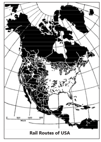
Rail-routes of the USA
- Most of the rail-routes of the USA have a linear pattern. In fact, in North America, railway lines were laid first, and then settlements were made along the rail-routes.
- To operate the rail-routes and increase the speed of rail transport, high technology, especially signalling techniques and radio communications, was used. The densely populated eastern parts have double and triple railway lines. East bound traffic is heavier than the west bound traffic.
- Northern Trans-Continental Rail-routes: It starts from Seattle on the Pacific coast and terminates at New York on the Atlantic coast. Portland, Minneapolis, St. Paul, Duluth, Miwaukee, Chicago are the major stations on this route. The east bound traffic includes number and minerals from the western states, raw silk, tea, and canned fish from Japan, apples from western states, and several agro-products, meat and livestock, etc. from the central states.
- Central Trans-Continental Rail-routes: It joins San Francisco on the Pacific coast with New York on the Atlantic coast via Salt Lake City, Omaha, Chicago, Pittsburgh, and Philadelphia. Canned fruits, vegetables, wool, livestock, meat, etc. are the major items of freight traffic.
- Southern Trans-Continental Rail-routes: It originates at Los Angeles, and bifurcates at Albuquerque. The northern branch goes to New York via Wichita, Kansas City, and Chicago. The southern branch goes to Orleans via Alpaso, Houston, and Galveston. Minerals, fruits, wood, meat, hides, cotton, etc. are the major products moved on this route
Railways of Asia
- Asia has nearly 15% of the world’s railways.More than one half lies in South Asia. Railways were developed mostly after the World War II. Japan has the densest rail net in Asia. India, China, and Japan are the important regions of rail development in Asia.
Air Transport
Factors Influencing Air Transport
- The air transport is greatly controlled by climatic conditions.
- Heavy rains, fog, and snow storms cause suspension of flying operations.
- Safe landing of aeroplanes becomes difficult for ground fogs.
- Relief of the land also influences air operations. Level lands are preferable so as to have better landing grounds.
- An airway system is determined by the prospect of getting maximum traffic on a given route
- In the light of the above factors, the density and distribution of air routes and services are very uneven in the world. There are no trans-oceanic air routes to the south of 35°S latitude. There are very few trans-oceanic routes as far north as 10°S latitude.
- Most of the airways of the world are found in the Southern Hemisphere. Two great focal regions of air transportation are central North America and West Central Europe. Out of 300 some schedule air carriers of the world, about four fifths operate in and from North America, and three fifths in the USA alone.
Air Transport in the USA
- In the USA air transportation has tremendously developed connecting points from coast to coast. The airways carry not only passengers but also vegetables, fruits, fish, manufactured products, and mail.
- Cargo plains from Miami, New Orleans and other centres in the USA carry articles such as poultry, cattle, automobiles, machinery, refrigerators, etc. to Latin American countries.
- There are several feeder routes, regional trunk routes, and trans-continental routs in the USA. The chief trans-continental routes are between north Atlantic ports and San Francisco Los Angeles and Seattle on the Pacific coast. There are more than 7,000 airports, nearly half of which are privately owned.
- The factors responsible for the development of air transport in the USA include: (i) large size of the country, (ii) large population, (iii) high standard of living, (iv) great development of industry, (v) large international trade, (vi) participation in scientific, political, and other national and international organization, and (vii) a very large tourist travel.
- Despite all the factors that foster participation in international aviation, only one fourth of the passenger ton miles of all USA airlines are international traffic, as against four fifths of those of the airlines of Western Europe.
- The major routes of the US international air feet serve six district areas: (i) Trans-Atlantic to Europe, (ii) Canada, (iii) Trans-Atlantic to Africa and Asia, (iv) Trans- Pacific to Asia, Australia and Pacific Islands, (v) Middle America, and (vi) South America.
Air Transport in Europe
- Western Europe has nearly one fourth of the world’s international airlines and one fifth of the world’s domestic and territorial airlines. The airways in Western Europe form a dense network every capital city and other important cities are served by airlines. The United Kingdom has as many as 15 airlines. The western European airlines account for one fourth of the world ton-miles of passenger, freight, and mail air traffic, and four fifths of this is international air traffic. Three fourths of the total ton-miles of air traffic is accounted for by passenger traffic, and 85% of the passenger traffic is international. This is due to the small size of the countries, intensive use of highways, railways, and inland waterways, the small number of domestic airlines, and the comparatively large number of international airlines serving many distant regions.
- In Russia, the Aeroflot is the principal airways, totaling 4, 00,000 kms. A dense network of cities of connects Russia west of Urals, Western Siberia and Central Asia. Twenty-one routes connect Moscow with 28 capital cities of Europe, Africa, Asia, and America. Passenger traffic of Aerofloat comprises 90% of the ton miles of freight and passenger traffic.
Air Transport in India
- India is situated on strategic route from and to Europe, Asia, Australia and Africa. Though domestic traffic is not commensurate with her area and size of population, yet international traffic is important. India has air transport agreements with 93 countries and her flights are regularly scheduled for these countries neighboring as well as distant. Air India, the international carrier, and Indian Airlines primarily a domestic carrier, serve 17 countries. The international airports are: Indira Gandhi International (Delhi), International Airport (Mumbai), Meenambakkam (Chennai), Dum Dum (Kolkata) and Thiruvananthapuram. Besides these, there are 92 major international and minor aerodromes meant for domestic air traffic.
Pipeline Transport
- Pipelines are the most specialized transport medium for carrying a variety of liquid and gaseous product. Over 99% of all material moved by pipeline are either crude petroleum, its refined derivatives, or natural gas.
- Pipeline transportation has distinct advantages. It provides the lowest cost. Pipelines transport bulk commodities in a relatively straight line through tropical forests and across deserts, bodies of water, and rugged mountains. Long life pipes, in most instances, buried to a depth of three feet or more, are not affected greatly by climatic conditions.
- The only visible features of a pipeline system are terminal tanks and the pumping stations, generally located 65 to 240 kms apart to maintain or boost pressure within the pipe and maintain regularity of flow. Once installed and in operation, the costs of maintenance and running are low.
- Only a few men are needed to operate and inspect a large pipeline system. Moreover, pipeline transportation is easily integrated with ships, barges, tankers, and trucks at economical costs.
- To achieve a high degree of efficiency, a pipeline system must be operated close to its capacity. Pipelines have been employed primarily for the transportation of crude petroleum, its derivations and natural gas.
- Many other products are now transported by pipeline. These include some solids and semi-solids in liquid suspensions. For example, finely ground iron and copper ores, limestone, gilsonite, coal slurry, and wood pulp are also moved by pipelines. In several areas finely ground minerals and chemicals, such as alcohols, acids, hydro carbon base chemicals, hydroxide, sulphur, and other are being transported by pipelines. Such transportation is quite common in the petro-chemical industry.
India
- Development of cheap and efficient means of transport is necessary for the progress of a large and developing country like India.
- India is a vast country with long distances from Kashmir in the north to Kanyakumari in the south and from Kandla in the west to Kohima in the east.
- All types of transport including railways, roadways, waterways, airways and pipelines are available in India.
Railways
Indian railway system is the main artery of the country’s inland transport. Railways virtually form the life-line of the country, catering to its needs for large scale movement of traffic, both freight and passenger, thereby contributing to economic growth and also promoting national integration. In fact, railways constitute the backbone of surface transport system in India.
Rail Traffic
Rail traffic is broadly divided into two segments, viz., (i) passenger traffic, and (ii) freight traffic.
Passenger Traffic
- For passenger service five types of trains are run by the Indian Railways, based on their speed and comfort levels— Ordinary Passenger trains, Express/Mail trains, superfast trains, Rajdhani Express, and Shatabdi and Jan Shatabdi trains.
- Sampark Kranti Express trains have been introduced to connect the national capital, Delhi with the state capitals and other important places. Further, Indian Railways have introduced computer reservation system making it possible to get instant reservation between any two stations from any booking office.
- The above developments have resulted in phenomenal growth in passenger earning by railways. The passenger earnings increased from 98.2 crore in 1950-51 to 46,280.4 crore in 2016-17. On an average, 14 million people arc moved by the Indian railways.
- There are plans to introduce high speed trains on following routes.
- Delhi-Agra
- Delhi-Chandigarh
- Delhi-Kanpur
- Nagpur-Bilaspur
- Mysore-Bengaluru-Chennai
- Mumbai-Goa
- Mumbai-Ahmedabad
- Chennai-Hyderabad
- Nagpur-Secunderabad
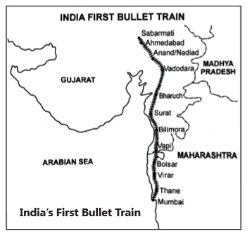
Bullet Train
- India’s first bullet train got off the ground on September 14, 2017 when its foundation stone was laid at Sabarmati near Ahmedabad in Gujarat. The train will run for a distance of 509 km (156 km in Maharashtra, 351 km in Gujarat and 2 km in Daman and Diu).
- The whole project is scheduled to be ready by August 15, 2022 to coincide with 75th Independence Day of India. The project will create 20,000 construction jobs, 4,000 operations jobs and 20,000 indirect jobs. It will prove a big boost to urban, industrial and other infrastructure development along its route. Its cost would be nearly 1.08,000 crores, 81% of which will be met through soft loan from Japan at a nominal interest rate of 0.1q per annum.
Other Bullet Train Routes Planned
- Delhi-Mumbai
- Mumbai-Chennai
- Mumbai - Nagpur
- Delhi-Kolkata
- Delhi-Chandigarh
- Delhi - Nagpur
- The top speed, maximum operational speed and average speed of the train will be 350 kmph, 320 kmph and 250 kmph respectively. China’s Shanghai Maglen with maximum operational speed of 430 kmph and average speed of 251 kmph is the fastest bullet train in the world.
Freight Traffic
- Along with passenger traffic, the freight traffic also increased tremendously. Development in industrial and agricultural sectors has generated high demand for rail transport. Major commodities transported by railways include coal, iron and steel, ores.
- Petroleum products and such essential commodities as food grains fertilizers, cement, sugar, salt, edible oils, etc. Consequently, freight traffic increased from 93.0 million tonnes in 1950-51 to 1,175 million tonnes in 2018-19.
- Transport effort measured in terms of net tonnes kilometres increased from 44.1 billion tonnes kilometers in 1950-51 to 683, 16 billion tonnes kilometres in 2018-19. Tonne kilometres are arrived at multiplying the total tonnage of goods carried by the number of kilometers over which they are moved.
Dedicated Freight Corridor Project
- A very ambitious plan of Dedicated Freight Corridors (DFC) was initiated in the year 2009 which aims at improving the freight carrying capacity of the Indian Railways, reducing the unit cost of transportation and improving service quality.
- It consists of two corridors viz. Eastern Dedicated Freight Corridor (EDFC) and Western Dedicated Freight Corridor (WDFC). The EDFC is 1,856 route kilometers (RKM) and extends from Dankuni near Kolkata to Ludhiana in Punjab while the WDFC is 1,504 route kilometer (RKM) and extends from Jawaharlal Nehru port in Mumbai to Dadri in Uttar Pradesh.
- A special purpose vehicle, the Dedicated Freight Corridor Corporation of India Limited has been set-up to implement the project. Out of 10,703 hectares of land to be acquired for the project 7,768 hectares (73 per cent) has already been awarded under the Railway Amendment Act (RAA) 2008. Following are the salient features of this project.
- Only goods trains will be allowed to operate on these corridors. These trains will run at a speed of 100 kilometres per hour.
- These corridors are planned to run along the existing railway routes, but will provide services to railway junctions.
- With a view to keep minimum impact on social and environmental aspects, these corridors will have provision of bypasses for thickly populated big cities.
- Rail track on DFCs will be strengthened by providing heavier and stronger rails on concrete sleepers. Transport cost will be reduced by increasing work efficiency.
- Efforts will be made to deliver the goods at their destinations well in time and minimise losses due to delayed deliveries of goods. Give impetus to industrial growth by providing cheap and efficient transport.
Metro Rail
- Metro rail offers fast, cheap and comfortable journey in metropolitan cities of India. It helps in reducing pressure on the existing road transport and provides clean and eco-friendly transport at the local level. With the introduction of metro rail in the big cities, traffic jams on road crossings have reduced considerably.
- It is a part of rapid mass transport and is of recent origin in India. The first rapid transit system in India was the Kolkata Metro, which started operations in 1984. The Delhi Metro was India’s first modern metro and third rapid transit system in India, after the Kolkata Metro and Chennai Mass Rapid Transit System.
- The Delhi Metro Rail started its operations in 2002 and is now providing transport facilities to most parts of the capital city. It also provides metro rail lines to most of the satellite towns like Gurgaon, Noida, Faridabad, Bahadurgarh, etc.
- Rapid Metro Rail Gurgaon is India’s first privately owned and operated metro rail system. It started its operations in November, 2013.
- After the grand success of Delhi Metro Rail, other cities are planning to have metro rails and in many cities this rail system is already in operation. The Government has planned to provide metro rail facilities in all cities of India having a population over two million.
- As metro rail projects are highly capital intensive. It is difficult to fund metro rail projects from Government exchequer only. In this context in order to create an ecosystem for proliferation of metro rail system in the country the Government of India has notified Metro Rail Policy, 2017.
- The policy imbibes on the learnings from international examples and bridges the much needed gap for enhancing the feasibility of metro rail projects from economic social and environmental perspective.
Roadways
- Roads have been existing in India for the last 5000 years. In early stages of Indian history, Ashoka and Chandragupta made efforts to construct roads. But the real progress was made during the Mughal period.
- A number of roads were laid during the Sultanate and Mughal periods. Most of the present trunk routes follow the Mughal routes. These routes were essential for strengthening and consolidating the empire.
- One such road was constructed by Sher Shah Suri which connected Peshawar to Kolkata. It was named as Grand Trunk (G.T.) Road and joined Amritsar with Kolkata after partition of India in 1947. Presently, it is also known as ‘Sher Shah Suri Marg’.
Classification of Roads
- The main significance of the Nagpur Plan lies in the fact that it classified roads into four categories on the functional basis. These are (i) National Highways (ii) State Highways (iii) District Roads and (iv) Village Roads. A brief description of each category is given as under:
National Highways
- The main roads which are constructed and maintained by the Central Public Works Department (CPWD) are known as the National Highways. These roads are meant for inter-state and strategic defense movements and connect the state capitals, big cities, important ports, big railway junctions and link up with border roads.
- The length of National Highways increased from 19,811 km in 1951 79.116 km in 2013. National Highways form the lifeline of road transport and constitute the framework of road system in India.
- Although, the percentage share of the National Highways to the total road length has decreased considerably from 4.95 per cent in 1951 to only 2 per cent in 2017, they carry nearly 40 per cent of the road traffic of India.
- The National Highways have been classified on the basis of carriage way width of the highway. Generally, a lane has a width of 3.75 m in case of single lane and 3.5 m per lane in case of multi-lane.
- The Government has embarked upon a massive National Highways Development Project (NHDP) in the country. The NHDP is the largest highway project ever undertaken in the country. The NHDP is being implemented mainly by NHAI in phases I to VII.
- Special Accelerated Road Development programme for North Eastern region (SARDP- NE): It envisages improvement of road connectivity to the State Capitals with District Headquarters in the North Eastern region. The proposed programme includes improvement of 10,141 km of roads comprising National Highways (4,798 km) and state Roads (5,343 km), to be implemented under Phase-A, phase B and Arunachal Pradesh Package for ‘Road Highways. Phase-A now consists improvement of 2,041 km of National Highways and 2,058 km of State Roads.
- Bharatmala Project: Established on July 31, 2015. This project aims at improving road connectivity to coastal/border areas/backward areas/religious places, tourists places/construction/rehabilitation/ widening of about 1500 bridges and 200 railway over bridges (ROBs)/railway under bridges (RUBS) on National Highways (Nils), improvement of newly declared NHs, providing connectivity to district headquarters connectivity improvement programme for char-Dham (Kedarnath, Badrinath, Yamunotri and Gangotri in Uttarakhand). The total investment for this plan is estimated at 10 trillion—the largest ever outley for a government road project. The Bharatmala Project includes development of around 51.000 km of road length comprising economic corridors, coastal roads and express ways and will be implemented in phases.
- Setu Bharatam Programme: Launched on 4th March, 2016, this programme aims at building bridges for safe and seamless travel on NHs. The main object of this programme is to make all National Highways free of railway crossings by 2019. This is being done to prevent frequent accidents and loss of lives at level crossings. Under this programme, 208 railway over bridges (ROBs) and railway under bridges (RUBs) are to be built at a cost of 20,800 crore. The details of these bridges are as: Andhra Pradesh (33), Assam (12), Bihar (20), Chhattisgarh (5), Gujarat (8), Haryana (10), Himachal Pradesh (5), and Jharkhand (11).
State Highways
- These are constructed and maintained by state governments and join the state capitals with district headquarters and other important towns. These roads are also connected to the national highways. The length of state roadways in India has almost tabled within a span of about four decades and has increased from 56,765 km in 1971 to 1.48,256 km in 2017. These roads constitute about 3.5 per cent of the total road length of India.
- Although, construction and maintenance of state highways is the responsibility of the concerned state governments, yet with the revamping of the Central Road Fund (CRF) in 2000, the Centre provides financial assistance for development of state roads. Further, to promote inter-state facilities and also to assist the State Governments in their economic development through construction of roads and bridges, Central Government provides 100 per cent grant for inter-state connectivity and 50 per cent grant for projects Of economic importance from CRF. Loan assistance from external funding agency is also taken by some states.
- The distribution of State Highways is very uneven. Maharashtra has the maximum length of state highways.This is followed by Gujarat, Madhya Pradesh, Rajasthan, and Andhra Pradesh (including Telangana). Smaller states such as Goa and states in hilly areas like Mizoram, Sikkim, Nagaland, Tripura. Etc. has less than five hundred km lengths of State Highways each.
- Conversion of State Highways to National Highways: The Government received proposals for declaration of more than 64,000 km of State roads as National Highways (NHs) from various State Governments, against which the Ministry has declared about 10000 km. of Roads/routes as new National Highways. So far 3180 km of State Highways have been converted to NHs.
District Roadways
- These roads join the district headquarters with the other places of the district. Development and maintenance of these roads fall within the purview of Zila Parishads. There has been more than five time’s increase in the length of district roadways. Formerly most of the district roads were unsurfaced and lacked bridges and culverts. But now the situation has changed and most of these roads are surfaced. Such a situation has improved connectivity and paved way for economic development.
- Maharashtra is at the top followed by Uttar Pradesh, Madhya Pradesh, Rajathan, Punjab, Karnataka, Assam, Himachal Pradesh, Haryana and Kerala
Village Roads
- The village roads are mainly the responsibility of village panchayats and connect the villages with the neighboring towns and cities. These are generally dusty tracks and are usable only during fair weather. They become muddy and unserviceable during the rainy season.
- Efforts have been made in the recent past to connect the villages with metaled roads. The length of these roads has increased by about 13 times from 2, 06,408 km in 1951 to 27, 49,805 km in 2011. These roads accounted for over 58.6 per cent of the, total road length, of the country in 2015.
- Border Roads: Border Roads Organization (BRO) Board was set up in May 1960 for accelerating economic development and strengthening defense preparedness through rapid and coordinated improvement of roads in the north and north-eastern border areas. This organization has constructed world’s highest road joining Chandigarh with Manali in Himachal Pradesh and Leh in Ladakh.
- This road runs at an average altitude of 4,270 metres above sea level and negotiates four passes at heights ranging from 4,875 to 5,485 metres.
- It is a vital road link in the western Himalayas and has considerably reduced the distance between Chandigarh and Leh. The Border Roads Organisation has now spread its activities throughout the country and is presently working in states of Rajasthan, Jammu and Kashmir etc.
Air Transport
- Air transport is the fastest mode of transport which has reduced distances and has led to drastic shrinking of the world. This mode of transport is indispensable when speed and time are the main considerations. One can easily cross and reach remote, inaccessible and hostile areas like lofty mountains, thick forests, marshy areas and sandy deserts by air transport which is almost impossible by other modes of transport.
- Air transport plays a vital role in times of emergency as well as in the event of natural and man-made calamities like foods, famines, epidemics and wars. Air transport is very essential for a vast country like India where distances are so long and the terrain and climatic conditions so diverse.
- The weather conditions in India are also quite congenial to air transport. Poor visibility due to clouds, fog and mist hinders air transport but India is lucky to have clear weather for most part of the year except for a short duration in rainy season and foggy particularly in North India.
Airports Authority of India (AAI)
- Airports Authority of India and National Airports Authority were merged on 1 April, 1995 to form Airports Authority of India (AAI). This authority is responsible for providing safe and efficient air traffic services and aeronautical communication services for effective control of air traffic in the Indian air space.
- It controls and manages the entire Indian space even beyond the territorial limits of the country in accordance with the norms set by International Civil Aviation Organisation (ICAO). It comprises of International Airports Division (IAD) and National Airports Division (NAD).
- At present India have 450 air ports/air strips of which 30 are international. There are 26 Civil Enclaves (3 international, 4 customs and 19 domestic) as well as 31 non-operational domestic airports.
- Development works in other remote areas like Jammu and Kashmir, Lakshadweep, Himachal Pradesh and Andaman and Nicobar Islands are also being taken up.
- The improvement of infrastructure at the airports needs heavy capital investment which the government cannot afford of its own. Therefore, private domestic and foreign investors including NRIs have been encouraged to participate in the process of improvement. Improvement and modernization of Indira Gandhi International Airport at Delhi and Shivaji Maratha International Airport at Mumbai, Chennai International Airport and Netaji Subhash Chandra Bose International Airport are some of the outstanding examples.
UDAN (Ude Desh ka Aam Nagrik)
- This scheme was launched in October, 2016 to make flying accessible and affordable for the masses in the regionally important cities. This is a first-of-its-kind scheme globally to stimulate regional connectivity through a market based mechanism. It provides a few seats at affordable passenger fares for an hour long fiight. Under UDAN, 70 airports and 128 routes are connected, and over 100 more unserved airports are to be connected in next rounds of bidding of routes.
- The Government offers fiscal support through Viability Gap Funding (VGF) and infrastructural development of under-utilized airport facilities to incentivize regional air traffic. UDAN ensures route profitability to airlines to sustain their operations through reducing operating costs by eliminating airport charges on UDAN routes, subsidizing ATF, providing market based subsidy for half of the seats, and guaranteeing three years exclusivity on routes.
- Under UDAN, 13 Regional Connectivity Scheme airports have been covered in the Eastern and North-Eastern region, 12 each in Northern and Western regions, and 8 in the Southern Region in the first round.
- So far 27 states/union territories have signed MOU (Memorandum of Understanding) with Central Government. Many private sector airlines are actively participating under this scheme.
National Civil Aviation Policy, 2016
- For the first time since Independence an Integrated Civil Aviation Policy was notified in June, 2016, which aims at creating an ecosystem that will push the growth of the civil aviation sector, which in turn, would promote tourism, increase employment and lead to a balanced regional growth.
- The Policy aims to take flying to the masses by making it affordable and convenient, enhance ease of doing business through deregulation, simplified procedures and e-governance and promote the entire aviation sector chain in a harmonized manner covering cargo, general aviation, aerospace manufacturing and skill development.
Water Transport
- Inland waterways were the chief mode of transportation before the advent of railways. Waterways are the cheapest means of transport and are most suitable for carrying heavy and bulky materials having low specific value water transport is a fuel efficient and environment friendly mode of transportation which has vast employment generation potential.
- Water transport suffered a great deal at the hands of roads and railways because it could not compete with the speed of road and rail transport. Although efforts are being made to revive the inland waterways, yet this mode of transportation is at its initial stage.
- Waterways provide only one per cent of total transport of India. The total length of navigable waterways in India comprising rivers, canals, backwaters, creeks, etc. is 14,500 km, out of which only 3,700 km is navigable by mechanized boats.
- Only 2,000 kin is actually used. As regards canals, we have a network of about 4,300 km of navigable canals, of which a stretch of 900 km is navigable by mechanized crafts. The emerging scenario shows that the inland waterways are greatly underutilized.
National Waterways
- In order to increase the significance of inland waterways and to improve their efficiency, the Government has identified 10 important waterways which are to be given the status of National Waterways. Some headway has already been made in this regard.
- Following five inland waterways have so far been declared as national waterways (NW). In addition, declaration of Barak River from Lakhpur to Bhanga (121 km) as sixth National Waterway is under consideration of the Government.
- Ganga is the most important inland waterway in India. It is navigable by mechanised boats upto Patna and by ordinary boats upto Hardwar. It has been declared as National Waterway No. 1. The entire route has been divided into three parts for development purposes.
- These parts are Haldia-Farakka (560 km), Farakka-Patna (46 km) and Patna-Allahabad (600 km). The National Waterways (Allahabad-Haldia stretch of Ganga-Bhagirathi-Hooghly River system) Act, 1982 has the provision that the regulation and development of this waterway is the responsibility of the Central Government.
- The ‘Jai Marg Vikas Project’ (on National Waterway-1; River Ganga) has been launched with the purpose of ensuring navigation of 1500 to 2000 tonne vessels by developing infrastructure and a fairway of 2.2 to 3 meters depth between Varanasi and Haldia covering a distance of 1380 km at an estimated cost of 5,369 crore. The project is being implemented by the Inland Waterways Authority of India.
- Brahmaputra is also navigable by steamers upto Dibrugarh for a distance of 1,384 km which is shared by India and Bangladesh. Its 891 km long stretch from Sadiya to Dhubri in Assam has been declared as a National Waterway and is being developed as an important inland waterway.
- Ro-Ro (Roll on-roll off) services have commenced between Dhubri and Hastingimari in July 2017. Roll on-roll off ships are vessels designed to carry wheeled cargo such as cars. Trucks, semi-trailer trucks, trailers and rail-road cars that are driven on and off the ship on their own wheels or using platform vehicle such as self-propelled modular transporter.
- Rivers of South India are seasonal and are not much suited for navigation. However, the deltaic channels of the Godavari, the Krishna and the Mahanadi, lower reaches of the Narmada and the Tapi, back waters of Kerala, Mandovi and Zuari rivers of Goa serve as waterways. The Godavari is navigable upto a distance of 300 km from its mouth. The Krishna is used as a waterway upto 60 km from its mouth.
- There are some navigable canals also which transportation serve as inland waterways. Buckingham canal in Andhra Pradesh and Tamil Nadu is one such canal which provides water transport for a distance of 413 km. It runs parallel to the eastern coast and joins all the coastal districts from Guntur to South Arcot.
- The other navigable canals are Kurnool-Cuddapah Canal (116.8 km), Son Canal (326 km), Odisha Canal (272 km), Medinipur Canal (459.2 km), Damodar Canal (136 km). Some of the irrigation canals of Uttar Pradesh and Punjab are also utilised for local transport.
- The Inland Waterways Authority of India (IWAI) was set up at Noida (Uttar Pradesh) on 27 October, 1987 for development and regulation of inland waterways. The Authority undertakes various schemes for development of Inland Water Transport (IWT) related infrastructure on National Highways.
- Under the National Waterways Act, 2016, 106 additional inland waterways have been declared as National Waterways. Based on techno economic studies, eight new National Waterways have been taken up for development in 2017-18. These include NW (National Waterway)— 16 (Barak river), three in Goa viz. NW-27 : Cumberjua, NW 68—Mandovi, NW-111-Zuari, NW 86 (River Rupnaraan), NW 97 (Sunderbans), NW-9 (Alappuzha-Kottayam-Athirampuzha Canal) and NW-37 (River Gandak).
Ports
- There are 13 major and 200 medium and small ports in India. The major ports are under the supervision of the Central Government while the minor ones are managed by the concerned State Governments. The 13 major ports handle about 90% of our foreign trade. The major ports on the west coast are Mumbai, Jawaharlal Nehru, Kandla, Marmagao, Mangalore and Kochi while on the east coast are Kolkata/Haldia, Paradwip, Vishakapatnam. Chennai, Ennor and Tuticorin.
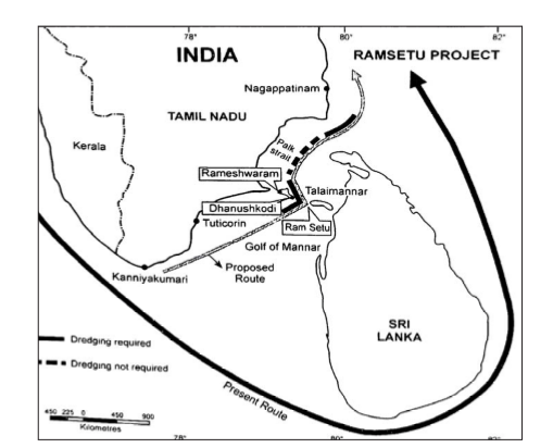
Ram Setu or Sethusamudram
- Also known as Adam’s Bridge, it is an ancient bridge which is made up of a 30 km long chain of shoals and sandbars between the southernmost island of Rameshwaram in Tamil Nadu State of India and Talaimannar of Sri Lanka.
- Two contradictory viewpoints are being put forward regarding the origin and structure of this bridge. According to Hindu mythology, this bridge was built by Lord Rama to attack the Lankan king Ravana.
- Archaeological Survey of India (ASI) in its affidavit submitted to the Hon’ble Supreme Court of India said that the bridge is a natural formation made up of shoals and sand bars formed due to several millennia of wave action and sedimentation. Geological Survey of India (GSI) found that Ram Setu was not a manmade structure but represented a geological divide between the Palk Bay and the Gulf of Mannar.
Banihal-Qazigund tunnel
Context
- National Highway Authority of India (NHAI) has announced that Banihal-Qazigund tunnel will be commissioned soon.
About:
- Banihal Qazigund Road Tunnel is an 5 km road tunnel at an elevation of 1,790 m in the Pir Panjal range in the Indian state of Jammu and Kashmir connecting Banihal and Qazigund.
- It is a double tube tunnel consisting of two parallel tunnels - one for each direction of travel. Each tunnel is 7 m wide and has two lanes of road.
- The two tunnels are interconnected by a passage at every 500 m for maintenance and emergency evacuation.
- The tunnel will have forced ventilation for extracting smoke and stale air and infusing fresh air. It will have state of the art monitoring and control systems for security.
Signi?cance:
- It will replace existing dependence on Jawahar Tunnel which is prone to avalanches and is closed time to time.
- The new Banihal-Qazigund tunnel’s elevation is 1,790 metres (5,870 feet), 400 metres below the Jawahar tunnel. This makes it less prone to avalanches.
Water aerodrome in Chilika Lake
Context
- The Airports Authority of India has proposed to set up a water aerodrome in Chilika Lake for starting amphibious aircraft operations in Odisha.
About
- This airport will be setup as a green ?eld project under UDAN regional connectivity scheme.
- However, there are some chances that this project may face regulatory hurdles.
- As for six months between October and March, Chilika turns into a temporary habitat for lakhs of migratory and residential birds.
- If an aircraft ?ies at low height, there is every chance of the birds getting hit.
- While the bird population will be in danger, safety of passengers of amphibious aircraft will also be jeopardized.
- As aerodrome may boost tourism at a Ramasar convention site which is also the largest brackish water lake of Asia but at the same time it may cause threat to migratory birds and safety of passengers.
Gas Trading Hub
Context
- Ministry of Petroleum & Natural Gas has given its nod to set up the gas trading hub(s)/exchange(s) in the country wherein the natural gas can be freely traded and supplied through a market mechanism.
About
- Draft National Energy Policy of NITI Aayog advocates for investment of US $ 150 billion in energy sector on an annual basis until 2040 to strengthen this sector for a better developmental pace.
What is a gas Trading/ Exchange hub?
- Natural gas hubs tend to be at the heart of gas infrastructure networks such as pipelines and lique?ed natural gas (LNG) terminals.
- The hub is used as a central pricing point for the network’s natural gas. In some cases, a ?nancial derivative contract is priced off gas delivered at this point as well.
Signi?cance of a Gas Trading Hub:
- Establishing a Gas Trading hub takes time, investment and political will ! to let prices develop without regulatory intervention.
- Gas hubs require pipeline networks and storage sites that allow supplies to be traded and moved about at short notice.
- Diverse sources of gas supply, including from domestic output, pipeline imports and overseas LNG shipments, are seen as favorable to avoiding domination by a few producers.
- A strong consumer base, with competing buying interests - for example, from household, power and industrial consumers - is also seen as crucial to developing a diverse market place.
- Regulation allowing domestic and foreign participants to trade and access pipelines and storage facilities is also seen as essential to establishing a gas hub. Participants also need to know they can trust a government not to intervene when prices go against local interests.
- An oversupply of gas is also seen as necessary in the early stages of developing a trading hub to allow the commodity to be exchanged in signi?cant volumes.
Major Gas Trading Hubs of the world:
- The world’s biggest natural gas hub is the Henry Hub in the U.S. state of Louisiana.
- Britain’s National Balancing Point (NBP) and the Dutch Title Transfer Facility (TTF) have emerged as the main natural gas hubs in Europe.
- Japan, China, India and Singapore in Asia are trying to establish gas trading hubs
Merger of Public Sector Banks

Prompt Corrective Action

Equalization Levy

Transfer of Surplus to Government of India
SEBI relaxes FPI norms