Geography: Origin of Earth
Stucco Sculpture

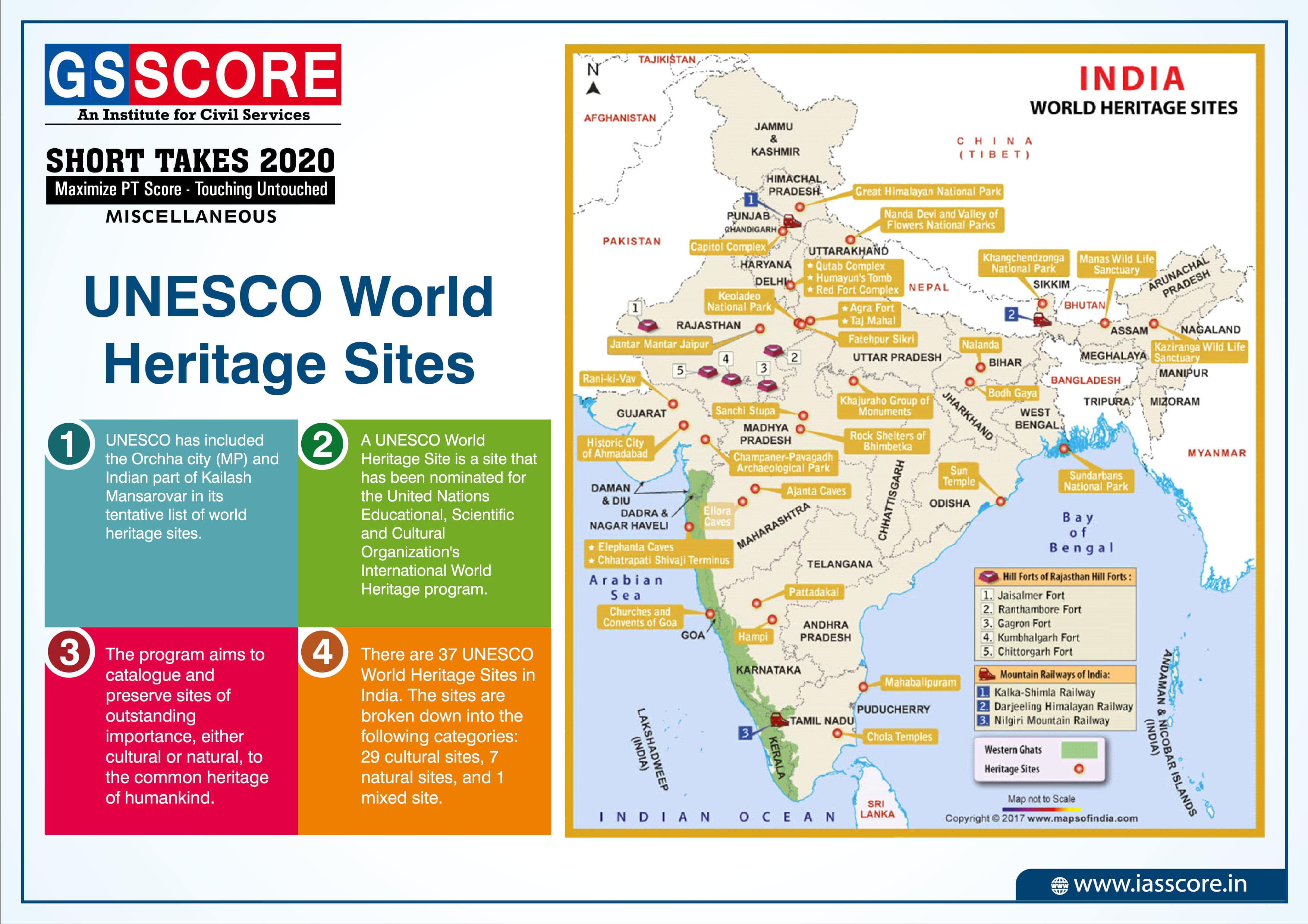
UNESCO World Heritage Sites
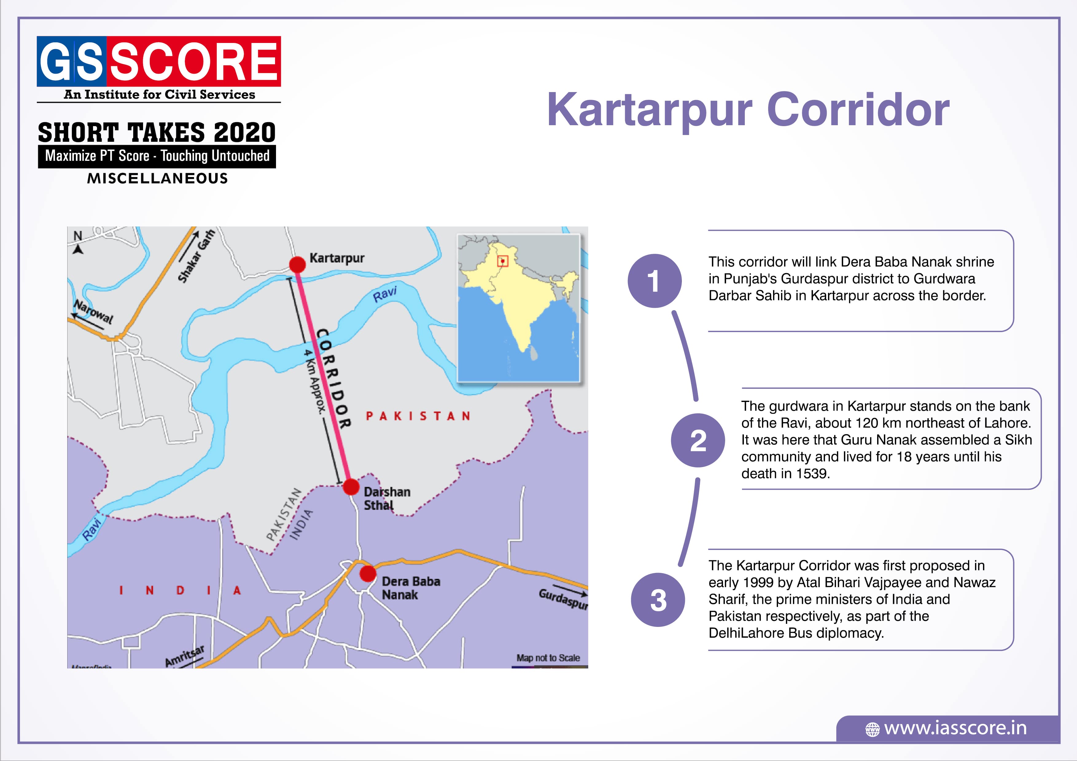
Kartarpur Corridor
Pradhan Mantri Kisan Samman Nidhi (PM-KISAN)

POCSO Act day

Universe
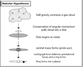
Theories on origin of the Universe
- Nebular Hypothesis: (Initial arguments were given by German philosopher Immanuel Kant Mathematician Laplace revised it in 1796). The hypothesis considered that the planets were formed out of a cloud of material associated with a youthful sun, which was slowly rotating.
- Planetesmial Hypothesis: In 1900, Chamberlain and Moulton considered that a wandering star approached the sun. Sir James Jeans and later Sir Harold Jefirey supported the argument.
- At a later date, the arguments considered of a companion to the sun to have been coexisting. These arguments are called binary theories.
- In 1950, Otto Schmidt in Russia and Carl Weizascar in Germany somewhat revised the ‘nebular hypothesis’.
- Big Bang Theory/ Expanding Universe Hypothesis: It was given by Edwin Hubble. According to “Big Bang Theory” everything in the universe emerged from a point known as ‘Singularity’ 15 billion years ago. Later on, this point expanded and inside it galaxies move apart due to which empty space between them expanded. All matter in the universe was created at one instant in fixed moment of time. A single fire ball existed along with wispy clouds of matter. When it exploded, it formed cluster of galaxies which exploded to form stars and then stars exploded to form planets.
Solar System
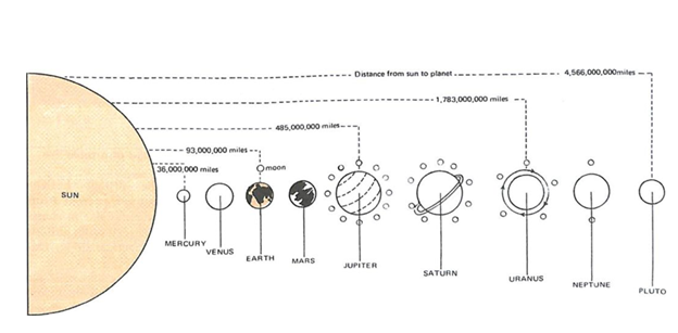
- The solar system comprises the Sun and its eight planets which are believed to have been developed from the condensation of gases and other lesser bodies.
- All the planets revolve round the Sun in elliptical orbits.
- Alternatively, the first four are called Terrestrial, meaning earth-like as they are made up of rock and metals, and have relatively high densities. The rest four are called Jovian or Gas Giant planets. Jovian means Jupiter-like. Most of them are much larger than the terrestrial planets and have thick atmosphere, mostly of helium and hydrogen.
- Till recently (August 2006), Pluto was also considered a planet. However, in a meeting of the International Astronomical Union, a decision was taken that Pluto like other celestial objects (2003 UB313) discovered in recent past may be called ‘dwarf planet’.
- The eight bodies officially categorized as planets are often further classified in several ways:
- By composition:
-
- Terrestrial or rocky planets: Mercury, Venus, Earth, and Mars.
- The terrestrial planets are composed primarily of rock and metal and have relatively high densities, slow rotation, solid surfaces, no rings and few satellites.
- Jovian or gas planets : Jupiter, Saturn, Uranus, and Neptune:
- The gas planets are composed primarily of hydrogen and helium and generally have low densities, rapid rotation, deep atmospheres and lots of satellites.
- By size:
-
- Small planets: Mercury, Venus, Earth, Mars. (The small planets have diameters less than 13000 km.)
- Giant planets: Jupiter, Saturn, Uranus and Neptune. (The giant planets have diameters greater than 48000 km.The giant planets are sometimes also referred to as gas giants.)
- By position relative to the Sun:
-
- Inner planets: Mercury, Venus, Earth and Mars.
- Outer planets: Jupiter, Saturn, Uranus, Neptune. The asteroid belt between Mars and Jupiter forms the boundary between the inner solar system and the outer solar system.
- Kuiper Belt: The Kuiper Belt (sometimes referred to as the Kuiper-Edgeworth Belt) is an area of the outer solar system that is estimated to stretch across 20 astronomical units (AU) of space.
- It contains small solar system bodies made mostly of ices.
- The ices are frozen volatiles (gases) such as methane, ammonia, nitrogen and water.
- It also is home to the known dwarf planets Pluto, Haumea and Makemake.
- The Kuiper-Edgeworth Belt is named for the astronomers Gerard Kuiper.
- The Kuiper Belt extends from roughly the orbit of Neptune (at 30 AU out to about 55 astronomical units) from the Sun.
- Oort cloud: The Oort cloud is an extended shell of icy objects that exist in the outermost reaches of the solar system.
- It is named after astronomer Jan Oort, who first theorized its existence.
- The Oort cloud is roughly spherical, and is thought to be the origin of most of the long-period comets that have been observed.
- Objects in the Oort cloud are also referred to as Trans-Neptunian objects. This name also applies to objects in the Kuiper Belt.
- Korolev Crater
About:
- European Space Agency’s (ESA) Mars Express mission has discovered an icy crater on Mars which has been named as Korolev Crater.
- Korolev Crater has been located by Mars Express Mission near the north pole of the Red Planet It is filled with a mound of water ice 60 kilometers across and nearly 2 kilometers thick.
- The water ice is a permanent feature.
- It has been anticipated that the crater traps a layer of cold air that prevents the ice melting even during the six-month-long northern summer on Mars, making this a yearlong winter wonderland.
Significance:
- Water on Mars has long been debated as the sign of existence of life on Mars, further existence of this huge reservoir of water will give thrust to it.
- To date, no proof has been found of past or present life on Mars but Cumulative evidence shows that during the ancient Noachian time period, the surface environment of Mars had liquid water and may have been habitable for microorganisms.
- Although, the existence of habitable conditions does not necessarily indicate the presence of life.
THE EARTH
- Earth is the third planet from the Sun and is the largest of the terrestrial planets.
- The Earth is the only planet in our solar system not to be named after a Greek or Roman deity.
- In size, it is the fifth largest planet. It is slightly flattened at the poles. That is why its shape is described as a
- The Moon (or Luna) is the Earth’s only natural satellite. The Moon is in synchronous rotation with Earth meaning the same side is always facing the Earth.
Evidence of the Earth’s Sphericity
- Ship’s visibility: When a ship appears over the distant horizon, top of the mast is seen before the hull & vice a versa.
- Sunrise & Sunset: Sun rises & sets at different times in different places. As earth rotates from west to east, places in east see sun earlier than those in the west.
- Lunar eclipse: Shadow cast by earth on the moon during the lunar eclipse is always circular.
- Driving poles on level ground on curved earth: Engineers while driving poles of equal length at regular intervals on the ground have found that they do not give a perfect horizontal level. Centre pole normally projects slightly above the poles at either end because of curvature of the Earth. Hence they have to make certain corrections for this inevitable curvature i.e. 8” to a mile.
- Aerial Photographs: Pictures taken from high altitudes by rockets & satellites show clearly the curved edge of the earth. This is perhaps the most convincing & up to date proof of earth’s sphericity.
Latitudes and Longitudes
Latitudes:
- The Equator is an imaginary line around the middle of the Earth. It is halfway between the North and South Poles, and divides the Earth into the Northern and Southern Hemispheres.
- The Earth is widest at its Equator. The distance around the Earth at the Equator, its circumference, is 40,075 kilometers (24,901 miles).
- Orbital plane is the plane formed by the orbit. The axis of the Earth is an imaginary line that makes an angle of 66½° with its orbital plane.
- Latitudes and Longitudes are imaginary lines used to determine the location of a place on earth. Parallels of Latitudes are the angular distance of a point on the earth’s surface, measured in degrees from the center of the Earth.
- As the earth is slightly flattened at the poles, the linear distance of a degree of latitude at the pole is a little longer than that at the equator.
- Besides the equator (0°), the north pole (90°N) and the south pole (90°S), there are four important parallels of latitudes–
- Tropic of Cancer (23½° N) in the Northern Hemisphere.
- Tropic of Capricorn (23½° S) in the Southern Hemisphere.
- Arctic Circle at 66½° North of the Equator.
- Antarctic Circle at 66½° South of the Equator.
Latitudinal Heat zones of the Earth
- The mid-day sun is exactly overhead at least once a year on all latitudes in between the Tropic of Cancer and the Tropic of Capricorn. This area, therefore, receives the maximum heat and is called the Torrid Zone.
- The mid-day sun never shines overhead on any latitude beyond the Tropic of Cancer and the Tropic of Capricorn. The angle of the sun’s rays goes on decreasing towards the poles. As such, the areas bounded by the Tropic of Cancer and the Arctic circle in the northern hemisphere, and the Tropic of Capricorn and the Antarctic circle in the southern hemisphere, have moderate temperatures. These are, therefore, called Temperate Zone.
- Areas lying between the Arctic circle and the north pole in the northern hemisphere and the Antarctic circle and the south pole in the southern hemisphere are very cold. It is because here the sun does not raise much above the horizon. Therefore, its rays are always slanting. These are, therefore, called Frigid Zone.
Longitudes:
- Longitude is the angle east or west of a reference meridian between the two geographical poles to another meridian that passes through an arbitrary point.
- All meridians are halves of great circles, and are not parallel to each other.
- They converge only at the north and south poles. A line passing to the rear of the Royal Observatory, Greenwich (near London in the UK) has been chosen as the international zero-longitude reference line and is known as the Prime Meridian.
- Places to the East are in the Eastern Hemisphere, and places to the West are in the Western Hemisphere.
- The antipodal meridian of Greenwich serves as both 180°W and 180°E. There are 360° of the meridians and the longitude of prime meridian is 0°.
- Length of all meridians is equal. The distance between two meridians is farthest at the equator and it decreases as we move towards poles and becomes zero at poles.
- They determine local time in relation to G.M.T. or Greenwich Mean Time, which is sometimes referred to as World Time.
Longitude and Time:
- Since the earth makes one complete revolution of 360° in one day or 24 hours, it passes through 15° in one hour or 1° in 4 minutes.
- The earth rotates from west to east, so every 15° we go eastwards, local time is advanced by 1 hour. Conversely, if we go westwards, local time is retarded by 1 hour.
International Date Line (IDL):
- The International Date Line (IDL) is an imaginary line on earth’s surface defining the boundary between one day and the next.
- The International Date Line is located halfway around the world from the prime meridian (0° longitude) or about 180° east (or west) of Greenwich, London, UK, the reference point of time zones. It is also known as the line of demarcation.
- A traveler going eastwards gains time from Greenwich until he reaches the meridian 180°E, when he will be 12 hours ahead of G.M.T.
- Similarly in going westwards, he loses 12 hours when he reaches 180°W. There is thus a total difference of 24 hours or a whole day between the two sides of the 180° meridian.
Circle of Illumination
- The circle of illumination is the circle that divides the day from night on the globe.
- Earth goes around the sun in an elliptical orbit. Note that throughout its orbit, the earth is inclined in the same direction.
Interior of the Earth
To understand the various endogenetic activities and their effects on the exogenetic landforms, it becomes very important to know about the interior of the Earth. The information regarding the earth’s interior can be known through various sources. Some of them are discussed below:
Direct Sources
- The most easily available solid earth material is surface rock or the rocks we get from mining areas.
- Volcanic eruption forms another source of direct information. As and when the molten material (magma) is thrown onto the surface of the earth, it becomes available for laboratory analysis. However, it is di?cult to ascertain the depth of the source of such magma.
Indirect Sources
- Analysis of properties of matter provides indirect information about the interior of the Earth.
- Another source of information is the meteors that at times reach the earth.
- The other indirect sources include:
- The gravitation force (g) is not the same at different latitudes on the surface. It is greater near the poles and less at the equator. This is because of the distance from the center at the equator being greater than that at the poles. The gravity values also di?er according to the mass of material. The uneven distribution of mass of material within the earth influences this value. The reading of the gravity at different places is influenced by many others factors.
- Seismic Activity: Some of the indirect evidences of seismic activity are:
- Study of ancient rocks and parts of interior now exposed to surface due to erosive activity.
- Study of lava erupted from volcanism from the interiors of the earth.
Seismological Evidences
The most authenticate source of knowledge about earth’s interior is through detailed study of earthquake waves. The seismic waves can be classified into two categories:
- Surface waves: These waves travel through the surface of the earth. Due to their amplitude, they are most destructive waves causing extensive damage on the surface of the earth.
- Types of Surface Waves:
- Love waves (L-waves) - its fastest surface waves and move on ground side to side. It is confined to surface of the crust love wave is wounded by Seismograph.
- Rayleigh waves- Rayleigh waves rolls along the ground just like a wave roll across a lake or an ocean.
- Body waves: These waves travel through the interiors of the earth. While travelling through interiors, their characteristics such as velocity and wavelength changes according to the density of the medium in which they are travelling. The body waves are recorded at different seismograph stations located at different places throughout the surface of earth. Body waves can be further categorized into
-
- Primary Waves: Also known as P-waves. These are longitudinal or compressive in nature. These waves can pass through solid as well as liquid medium. The velocity of these waves increases with increasing density and rigidity of the medium. (They travel faster in solid than in liquids)
- Secondary waves: Also known as S-waves. These are transverse or distortional in nature. These waves cannot pass through liquid medium. Their velocity also increases with increasing rigidity of the medium.
- Nature of Body Waves:
- These waves (both P and S waves) travel faster in rigid medium.
- Among P and S waves the velocity of P waves is more.
- These waves while passing from one medium to another medium of different density experiences refraction (bending from original path) similar to the light waves.
- Observations from the study of body waves:
- The velocity of body waves initially increases continuously denoting the increasing density of material with increasing depth in the part of outer layer of earth known as core.
- After around 100 km of depth, the velocity of both the waves shows a drastic decrease which denotes the less rigidity of the layer. This layer was named as asthenosphere and is made of plastic material.
- The body waves velocity increases, again denoting the increasing density with depth in mantle.
- After certain depth, the S-waves disappear and again re-emerge at surface of earth at an angle of 105°.The area where S-waves are not received is known as S-waves shadow region and lies between 105° on both sides. This concludes the presence of a liquid layer which forms outer core.
- The P-waves continue its journey and its velocity increases drastically representing very dense material in inner core. Due to high degree of refraction the P-waves are not recorded between 140° and 105°, and hence the region is known as P-waves shadow region.
- The velocity and wavelength of waves in different regions give a concrete evidence of composition of different layers of interior of earth.
Earth’s Interior
Based on all the evidences from Seismic data and their analysis, the earth’s interior has been divided into three layers.
Crust:
- This is the outermost layer of the earth. Its depth varies from 16 km – 40 km.
- It is thicker at continents (30 - 40 km) and its thickness underneath the ocean basin varies from 5-10 kms.
- At continental crust, the uppermost part is mainly sedimentary rocks followed by granite and gneisses rocks which overlie the basaltic rocks. The oceanic crust however is devoid of sedimentary or granitic cover and mainly consists of basaltic rocks.
- Thus, continental and oceanic crusts di?er in nature where continental crust is mainly granitic while oceanic crust is mainly basaltic in composition.
Mantle:
- This is the intermediate layer below crust. It extends upto 2900 km depth.
- It is composed of dense and rigid rocks having predominance of minerals like magnesium and iron. These rocks are similar to peridotite.
Core:
- It is the innermost layer of earth. It is divided into outer core and inner core.
- Outer Core: It extends from 2900 km to 5100 km depth from sea level. This is primarily made of iron with a small proportion of nickel, which is in liquid condition. At this depth, the S-waves suddenly disappear. Also, the velocity of P-waves abruptly decreases. Despite such a high pressure, outer core is in liquid form because of the presence of silicon which decreases the melting point of iron
- Inner Core: It lies beyond 5100 km depth. The average density increases to 13. This is mainly composed of pure iron and nickel in solid state. The outer liquid core moving around solid inner core of iron acts as a giant self-exciting dynamo which is responsible for magnetic field of earth.
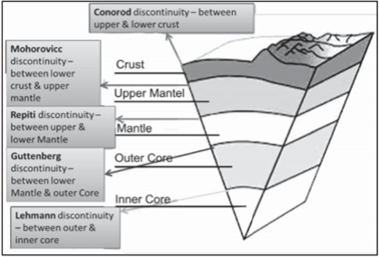
Discontinuities within the Earth’s Interior
Conrad discontinuity: The Conrad discontinuity corresponds to the sub-horizontal boundary in continental crust at which the seismic wave velocity increases in a discontinuous way. This boundary is observed in various continental regions at a depth of 15 to 20 km, between outer and inner crust however it is not found in oceanic regions.
Mohorovicic discontinuity: The Mohorovicic Discontinuity, or “Moho,” is the boundary between the crust and the mantle.
Repetti discontinuity: This discontinuity is found between upper and lower Mantle. This is marked by general decrease in velocity of seismic waves between upper and lower mantle.
Gutenberg discontinuity: The Gutenberg discontinuity occurs within Earth’s interior at a depth of about 1,800 mi (2,900 km) below the surface, generally between mantle and core ,where there is an abrupt change in the seismic waves (generated by earthquakes or explosions) that travel through Earth.
Lehmann discontinuity: The Lehmann discontinuity is an abrupt increase of P-wave and S-wave velocities at the depth of 220±30 km, discovered by seismologist Inge Lehmann. It appears beneath continents, but not usually beneath oceans, and does not readily appear in globally averaged studies. It is generally found between outer and inner core.
India’s first container movement on inland waterways
Context
- The Inland Waterways Authority of India (IWAI) will transport Pepsico’s container cargo from Kolkata to Varanasi via National Waterway-1 on the Ganga.
About
National Waterways-1
- Ganga-Bhagirathi-Hooghly river system from Allahabad to Haldia was declared as National Waterway No.1 vides National Waterway (Allahabad-Haldia stretch of the Ganga Bhagirathi- Hooghly river) Act 1982 (49 of 1982).
- It became operative in 1986 after the formation of the IWAI and covers a distance of 1620 kms.
- The Hooghly river portion of the waterway from Haldia to Nabadwip is tidal. Sea going vessels navigate up to Calcutta (140 kms) and the fairway up to Calcutta is maintained by the Calcutta Port Trust. From Calcutta up to Tribeni there are no restrictions for navigation by inland vessels of a loaded draft up to 4m.
Jal Marg Vikas Project:
- The Jal Marg Vikas Project (JMVP) on NW-1 is being implemented with the financial and technical support of the World Bank.
- The Project entails development of fairway with 3 meters depth between Varanasi and Haldia (Phase-I) covering a distance of 1380 km at an estimated cost of Rs. 5369 crore with target for completion in six years.
- Through the project, the government is also trying to boost infrastructure development such as ferry services, multi-modal and inter-modal terminals, Roll on-Roll off (Ro-Ro) facilities and navigation aids.
- The project is expected to be completed by March 2023.
Inland Waterways Authority of India (IWAI):
- The Inland Waterways Authority of India (IWAI) came into existence in 1986 for development and regulation of inland waterways for shipping and navigation.
- The Authority primarily undertakes projects for development and maintenance of IWT infrastructure on national waterways through grant received from Ministry of Shipping.
- India has about 14,500 km of navigable waterways which comprise of rivers, canals, backwaters, creeks, etc.
Significance
- This would be the country’s first container movement on inland vessel post-independence, and a milestone moment in the history of India’s IWT sector.
- The mode of communication is considered both cost effective and environment friendly.
- Container cargo transport comes with several inherent advantages. Even as it reduces the handling cost, allows easier modal shift, reduces pilferages and damage.
- It also enables cargo owners to reduce their carbon footprints.
- The event coincides with another momentous day for IWT in India as IWAI’s first foray into Public Private Partnership (PPP) model will become a reality with the handing over of operation and management of its terminals in Kolkata to M/s Summit Alliance Port East Gateway (India) Pvt Ltd.
India’s first multi-modal terminal on inland waterways
Context
- Prime Minister Narendra Modi inaugurated India’s first multi-modal terminal on the River Ganga in Varanasi.
About
- This is the first of the four multi-modal terminals being constructed on the National Waterway-1 (River Ganga) as part of the World Bank-aided ‘Jal Marg Vikas Project’ of the Inland Waterways Authority of India.
- The total estimated cost of the project is Rs 5,369.18 crore, which will be equally shared between the Government of India and the World Bank.
- Operation, management and further development of the terminal are proposed to be entrusted to an operator on public-private partnership model. Selection of the operator through an international competitive bidding is at an advanced stage and is expected to be completed by December 2018.
Jal Marg Vikas Project
- It aims at developing the stretch of the river between Varanasi and Haldia for navigation of large vessels weighing up to 1,500 tonnes to 2,000 tonnes.
- It will promote inland waterways as a cheap and an environment-friendly means of transportation, especially for cargo movement.
- The Inland Waterways Authority of India (IWAI) is the implementing agency.
- The project entails construction of three multi-modal terminals (Varanasi, Sahibganj and Haldia), two inter-modal terminals, five roll-on-roll-off (Ro-Ro) terminal pairs, night navigation facilities, modern methods of channel marking etc.
- The Jal Marg Vikas Project is expected to be completed by March, 2023.
Significance
- The multi-modal terminal project and proposed freight village in Varanasi are expected to generate 500 direct employment and more than 2,000 indirect employment opportunities.
- Container cargo transport also comes with several inherent advantages. Such as, it reduces the handling cost, allows easier modal shift, reduces pilferages and damage and also enables cargo owners to reduce their carbon footprints.
Bhungroo water harvesting system
Context
A Geneva based firm Firmenich has installed a unique water harvesting system, named as Bhungroo, near Coimbatore to help farmers overcome water deficiency during dry months.
About
- It is a water harvesting technique that uses an injection module to store excess rain water underground. Farmers can then use the same water for irrigation during summer and winter.
- Bhungroo means “straw” in Gujarati and has been in use in Gujarat since 2002. It is currently being used in Tamil Nadu for horticulture crops.
- It is also used to prevent soil salinity in marshy areas by checking water logging by injecting excess water into the ground.
Technology involved:
- Lowest point of the catchment area is identified after hydrological survey of the area.
- A pipe with a diameter of 5 inches is drilled into the ground up to aquifer or water table.
- Rain water usually flow towards lowest point and goes into the ground.
Significance
- Water stored helps in maintaining ground water level and thus moisture of the soil is maintained during dry spells.