Geography: Physiography of India
Physiography of India
- India is the seventh largest country in the world. It has land boundaries of 15,200 km and 6100 km long coast line. India’s landmass covers 3.28 million square kilometer of area. This accounts for nearly 2.42 percent of the total geographical area of the world. India is the largest country in terms of area and population in South-Asia. It is surrounded by ocean.
- India is strategically located in Indian Ocean. It commands sea routes between Europe and Africa, South East Asia, far East Asia and Oceania. It is because of this that India shares good trade relation between many countries since ancient times. India has a good location in terms of sea and also well connected by land. Various passes like Nathu-La (Sikkim), Shipki-La (Himachal Pradesh), Zoji-La and Burji la pass (Jammu & Kashmir) have their own importance.
- The main India-Tibet trade route that connects Kalimpong near Darjeeling with Lhasa in Tibet passes through Jelepa La. Several passes have provided a passage to many ancient travelers. These routes are not only important for trade but also to exchange ideas and culture.
- India has the topographical diversity .The reasons for variation in the topography could be:
- Differences in the rock formations. These landmasses have been formed in different geological periods.
- Number of processes such as weathering, erosion and deposition has modified these features to their present forms.
- India is a country of physical diversity. There are high mountain peaks in some areas while in others, lie the flat plains formed by rivers. On the basis of physical features, India can be divided into following six divisions:
- The Northern mountains
- The Northern Plains
- The Peninsular Plateau
- The Indian Desert
- The Coastal Plains
- The Islands.
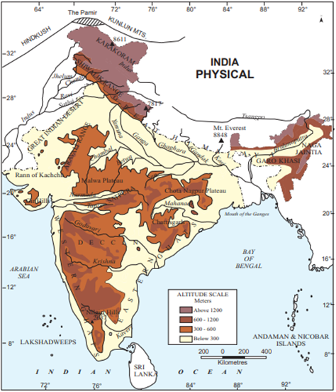
1. The Northern Mountain: It is divided into three groups. They are:
(i) The Himalayas
(ii) The Trans Himalayas
(iii) The Purvanchal hills
The Himalayan Mountains
- Himalayas are the young fold mountains. This is the highest mountain range of the world. Himalayas act as natural barrier. The extreme cold, snow and rugged topography discourage the neighbors to enter India through Himalayas. They run from west-east direction from Indus to Brahmaputra along the northern boundary of India covering a distance of 2500 km. Their width varies from 400 km in the west and 150 km in the East. The Himalayas may be divided into three parallel ranges:
-
- Greater Himalayas or Himadari
- Lesser Himalayas or Himachal
- Outer Himalayas or Siwaliks.
- The Greater Himalayas or Himadari: The Greater Himalayas comprises of the northern most ranges and peaks. It has an average height of 6000 metres and width lies between 120 to 190 Kms. It is the most continuous range. It is snow bound and many glaciers descend from this range. It has high peaks like Mt. Everest, Kanchenjunga, Makalu, Dhaulagiri, Nanga Parbat etc. having a height of more than 8000 metres. Mt. Everest (8848 m) is the highest peak of the world and Kanchenjunga is the highest peak of Himalaya in India. High Mountain passes also exist in this range, namely, Bara Lacha-La, Shipki-La, Nathu-La, Zoji-La, Bomidi-La etc. The Ganga and Yamuna rivers originate from this Himalayas.
- The Lesser Himalayas or Himachal: The altitude of this range lies between 1000 and 4500 metres and the average width is 50 km. The Prominent ranges in this are Pir Panjal, Dhaula Dhar and Mahabharata ranges. It compresses of many famous hill stations like Shimla, Dalhousie Darjeeling, Chakrata, Mussoorie, Nanital etc. It also comprises of famous valleys like Kashmir, Kullu, Kangra etc.
- The Outer Himalayas or the Siwaliks: It is the outer most range of the Himalayas. The altitude varies between 900-1100 meters and the width lies between 10km-50 km. They have low hills like Jammu Hills, etc. The valleys lying between Siwalik and Lesser Himalayas (Himachal) are called ‘Duns’ like Dehra Dun, Kotli Dun and Patli Dun.
The Trans-Himalayan ranges
- It extends north of greater Himalaya and parallel to it is called Zaskar range. North of Zaskar range lies Ladakh range. The Indus River flows between Zaskar and Ladakh range. The Karakoram Range lie extreme north of the country. K2 is the second highest peak of the world.
The Purvanchal hills
- It comprises Mishami, Patkoi, Naga, Mizo hills which are located in eastern side. The Meghalaya plateau is also part of these hills which includes the hills of Garo, Khasi and Jaintia.
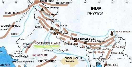
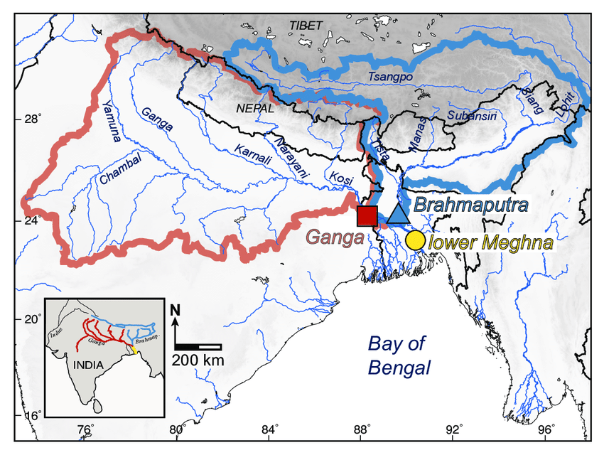
2. The Northern Plains
- The Northern Plains are located between south of the Himalayas and north of the Peninsular plateau. It is formed by the deposition of the sediments brought by three main river systems namely: the Indus, the Ganga and the Brahmaputra. From Punjab in the west to Assam in the east, this plain is about 2400 km long. Its width varies from about 300 km in the west to about 150 km in the east. It mainly includes the states of Punjab, Haryana, Uttar Pradesh, Bihar, West Bengal and Assam. This plain is very fertile due to alluvial sediments brought by the rivers from the Himalayas. This plain is one of the largest and most fertile plains of the world. Major crops such as wheat, rice, sugarcane, pulses, oil seeds and jute are grown here. Due to proper irrigation, the plain makes significant contribution in the production of food grains. The Northern plain is broadly divided into two parts :
- The Western plain
- The Ganga-Brahmaputra plain
a) The Western Plain
- This plain is formed by the river system of the Indus. It lies to the west of Aravallis. This plain is formed due to deposits brought by the rivers like the Satluj, the Beas and the Ravi. This part of the plain has doabs.
b) The Ganga-Brahmaputra plain
- It is also formed by the deposition of the sediments brought by two main river systems, the Ganga and the Brahmaputra. The early civilizations like Mohenjo-Daro and Harappa also called river valley civilizations were spread over plain areas. This is because of the availability of fertile land and water through the river networks.
3. The Peninsular Plateau
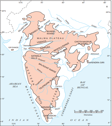
- Peninsular plateau is a triangular shaped table land. It is part of ancient land mass called Gondwana level. It covers an area of nearly 5 lakh sq.km. It is spread over the states of Gujarat, Maharashtra, Bihar, Karnataka and Andhra Pradesh River Narmada divides the peninsular plateau into two parts: The central highlands and Deccan Plateau.
- The central Highlands: It extends from Narmada river and the northern plains. Aravallis is the important mountain which extends from Gujrat through Rajasthan to Delhi. The highest peak of the Aravallis hills is Gurushikhar (1722m) near Mt. Abu. The Malwa Plateau and Chhota Nagpur plateau are parts of the central highlands. River Betwa, chambal and Ken are the important river of Malwa plateau while Mahadeo, Kaimur and Maikal are the important hills of chhota Nagpur plateau. The valley of Narmada is lies between the Vindhyas and the Satpura which flows east to west and joins the Arabian sea.
- The Deccan Plateau: The Deccan plateau is separated by a fault (A fracture in the rock along which rocks have been relatively replaced), from Chota Nagpur plateau. The black soil area in the Deccan plateau is known as Deccan trap. It is formed due to volcanic eruptions. This soil is good for cotton & sugarcane cultivation. The Deccan plateau is broadly divided into: (a) The Western Ghats (b) The Eastern Ghats
(a) The Western Ghats: Western Ghats or Sahyadris lie on the Western edge of the Deccan plateau. It runs parallel to the western coast for about 1600 km. The average elevation of the Western Ghats is 1000 metres. The famous peaks in this area are Doda Betta, Anaimudi amd Makurti. The highest peak in this region is Anaimudi (2695m.). Western ghats are continuous and can be crossed through passes like Pal Ghat, Thal Ghot and Bhor Ghat. The rivers like Godavari, Bhima and Krishna flow eastward while the river Tapti flows westward. The streams form rapids & water falls before entering the Arabian Sea. The famous water falls are Jog falls on Sharavati, Shiva Samudram falls on Kaveri etc.
(b) The Eastern Ghats: The Eastern Ghats are discontinuous low belt. Their average elevation is 600m. They run parallel to the east coast from south of Mahanadi valley to the Nilgiri hills. The highest peak in this region is Mahendragiri (1501 m). The famous hills are Mahendragiri hills, Nimaigiri hills in Orissa, Nallamallai hills in Southern Andhra Pradesh, Kollimalai and Pachaimalai in Tamilnadu. The area is drained by the Mahanadi, Godawari, Krishna and Kaveri river systems. The Nilgiri hills join Western & Eastern Ghats in the south.
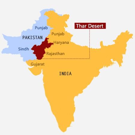
4. The Indian Desert
- The Indian Desert lies towards the western margin of Aravali Hills. It is also called Thar Desert. It is the ninth largest desert in the world. It spreads over the states of Gujarat and Rajasthan. This region has semi-arid and arid weather conditions. It receives less than 150 mm of rainfall per year. The vegetation cover is low with thorny bushes. Luni is the main river in this area. All other streams appear only at the time of rainfall otherwise they disappear into the sand.
5. The Coastal Plains
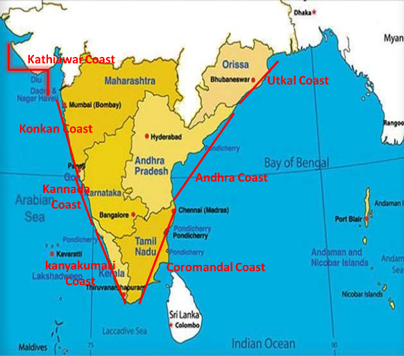
- The coastal plains in India run parallel to the Arabian Sea & Bay of Bengal along the Peninsular Plateau. The western coastal plain is a narrow belt along the Arabian sea of about 10-20 km wide. It stretches from Rann of Kachchh to Kanya Kumari.
- Western coastal plains comprises of three sectors (i) Konkan Coast (Mumbai to Goa), (ii) Karnataka coast from Goa to Mangalore (iii) Malabar Coast (Mangalore to Kanya Kumari).
- The eastern coast runs along Bay of Bengal. It is wider than the western coastal plain. Its average width is about 120 kms. The northern part of the coast is called Northern Circar and the southern part is called Coromandal Coast.
- Eastern coastal plain is marked by Deltas made by the rivers Mahanadi, Godavari, Krishna and Kaveri. The Chilka largest salt water lake in India in Odisha is located to the south of Mahanadi Delta. The coastal plains are belts for growing spices, rice, coconut, pepper etc. They are centres of trade & commerce.
- The coastal areas are known for fishing activities, therefore large number of fishing villages have developed along the coasts. Vembanad is famous lagoon which is located at Malabar Coast.
6. The Islands
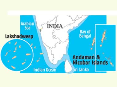
- India has two main groups of Islands. There are 204 islands in Bay of Bengal called as Andaman and Nicobar Islands and 43 islands in Arabian Sea called as Lakshadweep islands
- The Andaman & Nicobar Island extend from north to south in Bay of Bengal.
- They are bigger in size. An active volcano is located on the Barren Island in Andaman & Nicobar group of islands. Lakshadweep islands are located near Malabar Coast of Kerala in the Arabian Sea.
- They cover an area of 32 sq km. Kavarati is the capital of Lakshdweep.
- These islands are formed by corals and endowed with variety of flora and fauna. These islands are important tourist attraction under water activities like snokling, such diving, deep sea diving and other sports make these island more popular.
Gulf of Guinea
Context
- Recently, nine Chinese and eight Ukrainian seamen have been abducted after two merchant vessels came under attack in Cameroonian waters.
- The attacks took place off the Port of Douala.
About
Gulf of Guinea
- The Gulf of Guinea is the north-easternmost part of the tropical Atlantic Ocean.
- The intersection of the Equator and Prime Meridian (zero degrees latitude and longitude) is in this gulf.
- Among the many rivers that drain into the Gulf of Guinea are the Niger and the Volta.
Piracy in the Gulf of Guinea:
- Piracy in the Gulf of Guinea affects a number of countries in West Africa as well as the wider international community making it becoming an issue of global concern.
- Pirates here are often part of heavily armed criminal enterprises, who employ violent methods to steal oil cargo.
- The International Maritime Bureau (IMB) has recently described the Gulf of Guinea as the most dangerous area in the world for shipping.
- According to its estimations, 73 percent of all sea kidnappings and 92 percent of hostage-takings occur there, with pirates normally taking sailors for ransom.
Causes of piracy in the Gulf of Guinea:
- Youth unemployment and widespread povertyare one of the main triggering factors for piracy in the Gulf of Guinea, and as admitted by the UN Security Council during a meeting set to discuss a mission to the region ‘any comprehensive anti-piracy strategy might also need to take into account root causes, including high levels of youth unemployment’.
- Severe political disputesare considered another reason contributing to the rise of piracy in the area, and in some cases directly feeding into the piracy activity itself.
- Of particular relevance are the activities of the Movement for the Emancipation of the Niger Delta, in the south of Nigeria; this organization has publicly stated to steal and smuggle oil ‘as a form of re-appropriation of wealth and as a form of protest’.
- Another major and relevant controversy has involved the governments of Cameroon and Nigeria; the two countries have been in dispute about the sovereignty over the Bakassi Peninsula, which has caused a lack of cooperation between the governments resulting in poor control over illegal activities.
- Corruption is another major contributing factor, especially with regards to the case of Nigeria. Attention has been called towards the political protection that some of those who attack installations and personnel of oil companies, especially in the Niger Delta, enjoy protection from certain local authorities.
Tesla-style giga factories
Context
- India is planning for $4 billion Tesla-scale battery storage plants to expedite India’s battery storage revolution.
About
More on news:
- India is planning to build at least four Tesla-style giga factories to manufacture batteries with an investment of around $4 billion to switch to electric vehicles to curb pollution and reduce the dependence on foreign oil.
- According to NITI Aayog, India will need 6 such gigawatt-scale facilities (of 10 GWh each) by 2025 and 12 by 2030 but it does not include the export market potential. Hence, the base scenario envisions 11 factories by 2025 and 24 by 2030.
- On the demand creation side, the plan involves providing tax credits at the retail level and state-level grants to promote usage of electric vehicles.
- Union budget of 2019-20 also announced tax breaks for setting up mega-manufacturing plants for solar photovoltaic cells, lithium storage batteries and solar electric charging infrastructure.
India’s Renewable Energy
- India has become one of the top renewable energy producers globally.
- It has a capacity of about 80 gigawatts (GW) and is running the world’s largest renewable energy programme, with plans to achieve 175GW by 2022 and 500GW by 2030, as part of its climate commitments.
- It is the world’s third-largest oil consumer. Hence, its imports are more than 80% of its oil requirements and around 18% of its natural gas.
- Currently, there are no indigenous battery manufacturers in India. Almost all of the electric lithium-ion batteries are imported from China.
- The upcoming four Tesla-inspired Gigafactories in India seek to address that problem.
Significance of this plan
- Demand Side: Factories are set up to secure India’s energy needs directed by NITI Aayog and it aims to accomplish what Tesla has done at its Gigafactory in Nevada, USA.
- Consumer needs: This plan aim to fulfil the needs of consumer’s electronics industry and electricity grids apart from Electronic Vehicles.
- Self-Sufficient: This step will reduce India’s dependence on foreign oil.
- Electric vehicle: This plan will enable India to develop an electric vehicle ecosystem including manufacturing and R&D.
- Environment: It aims to achieve clean energy targets and the irregular nature of electricity from clean energy sources such as solar and wind.
Support extended by the Indian government
- Government may offer a number of incentives to manufacturers such as concessional financing options with around 3% foreign exchange hedge on overseas loans and a fixed 3% interest subvention on loans availed in Indian rupees.
- In addition, a reduction in minimum alternative tax (MAT) may be offered.
- Another support includes an investment-linked tax incentive.
- It may also offer an output-linked subsidy on kilowatt hour (KWh) of sold cells.
Global Performance
- USA provided a R&D capital support of $2.4 billion of grants for battery manufacturing under American Recovery and Reinvestment Act (ARRA) in 2009; it also included a $1.5 billion in grant to develop a domestic battery supply chain.
- States such as South Carolina, Georgia and Michigan have also given tax breaks for setting up battery manufacturing.
- Europe has been at the forefront of promoting battery manufacturing with the European Union Battery Alliance planning with the goal of opening production sites in France and Germany.
- There is also concessional finance with funds from European fund for strategic investments (EFSI) set up by European Investment Bank (EIB) for setting up such giga scale factories.
Tigers under high stress
Context
- A study conducted by the Hyderabad-based Centre for Cellular and Molecular Biology (CCMB) has found that the Tigers in Bandhavgarh, Kanha and Sariska are under tremendous stress induced by tourism and this is probably affecting their reproduction.
About
Highlights of the study
- Results of the study were published in CCMB’s Laboratory for Conservation of Endangered Species.
- This study is based on the comparison between the samples of fecal glucocorticoid metabolite (fGCM) of the same tigers from the same location during tourist and off-peak seasons, which is regarded as a marker of stress.
- The stress levels of tigers during the 8-9 month tourism period were very high. Although females are known to undergo more stress, study shows that males were also under tremendous stress.
- Study could also be distinctly correlated with the stress levels depending on the number of vehicles entering the tiger reserves.
- The report suggests that unsustainable wildlife tourism causes distinct physiological stress in tigers in protected areas. Recently introduced tigers in Sariska Tiger Reserve, Rajasthan, failed to reproduce effectively presumably due to high levels of stress caused by high anthropogenic disturbance.
- It recommends strict regulation of vehicular traffic, and reducing other anthropogenic disturbances.
What the study focused on?
- The study examines the relationship between anthropogenic disturbances and physiological stress levels in tiger populations in protected areas.
- The research team collected a total of 341 fGCM, a stress marker among tigers, samples from Bandhavgarhand Kanha reserves during tourist and off-peak seasons, besides data on various anthropogenic disturbances, including tourism activities.
Current status of Tigers in India
- The count of big cats is increasing constantly. In 2006, there were 1,411 tigers, which increased to 1,706 in 2010 and 2,226 in 2014.
- Around 97 % of the world tiger population perished in the last 100 years and according to the latest statistics, only 3,890 tigers are left in the world, out of which 2,226 are in India.
- Major threats to the tiger include habitat destruction, habitat fragmentation and commercial poaching for fur and body parts, which have simultaneously reduced tiger populations in the wild.
- The country’s first Wildlife Crime Cellhas been established by the forest department at Melghat Tiger Reserve to stop the poaching of tigers and other wild animals.
- Uttarakhandhas recorded a massive jump in the tiger numbers with the Corbett Tiger Reserve becoming home to 45 more tigers since 2015 and the Rajaji Tiger Reserve having 18 more big cats than were recorded in the 2014 tiger census.
- Uttarakhand has the country’s second highest tiger population after Karnataka, according to the 2014 tiger census.
NATIONAL TIGER CONSERVATION AUTHORITY
- It is a statutory body under the Ministry of Environment, Forests and Climate Changeconstituted under enabling provisions of the Wildlife (Protection) Act, 1972, as amended in 2006, for strengthening tiger conservation, as per powers and functions assigned to it under the said Act.
International or Global Tiger day
- It is observed on 29 July every year, which is dedicated to the worldwide awareness and support for tiger conservation.
- It was created when 13 countries came together in 2009 and pledged to double the world’s Tiger population by 2022 -- the next "Year of the Tiger" on the Asian lunar calendar.
Steps taken
- In 2010, the governments of 13 countries where wild tigers roam decided that the business-as-usual approach was not enough.
- They came together and committed to TX2 - the most ambitious conservation goal set for a single species – to double wild tigers by 2022, the next Chinese Year of the Tiger.
- Project Tiger was launched in 1973 in India that aims at conserving Tiger.
The New Delhi Declaration on Asian Rhinos 2019
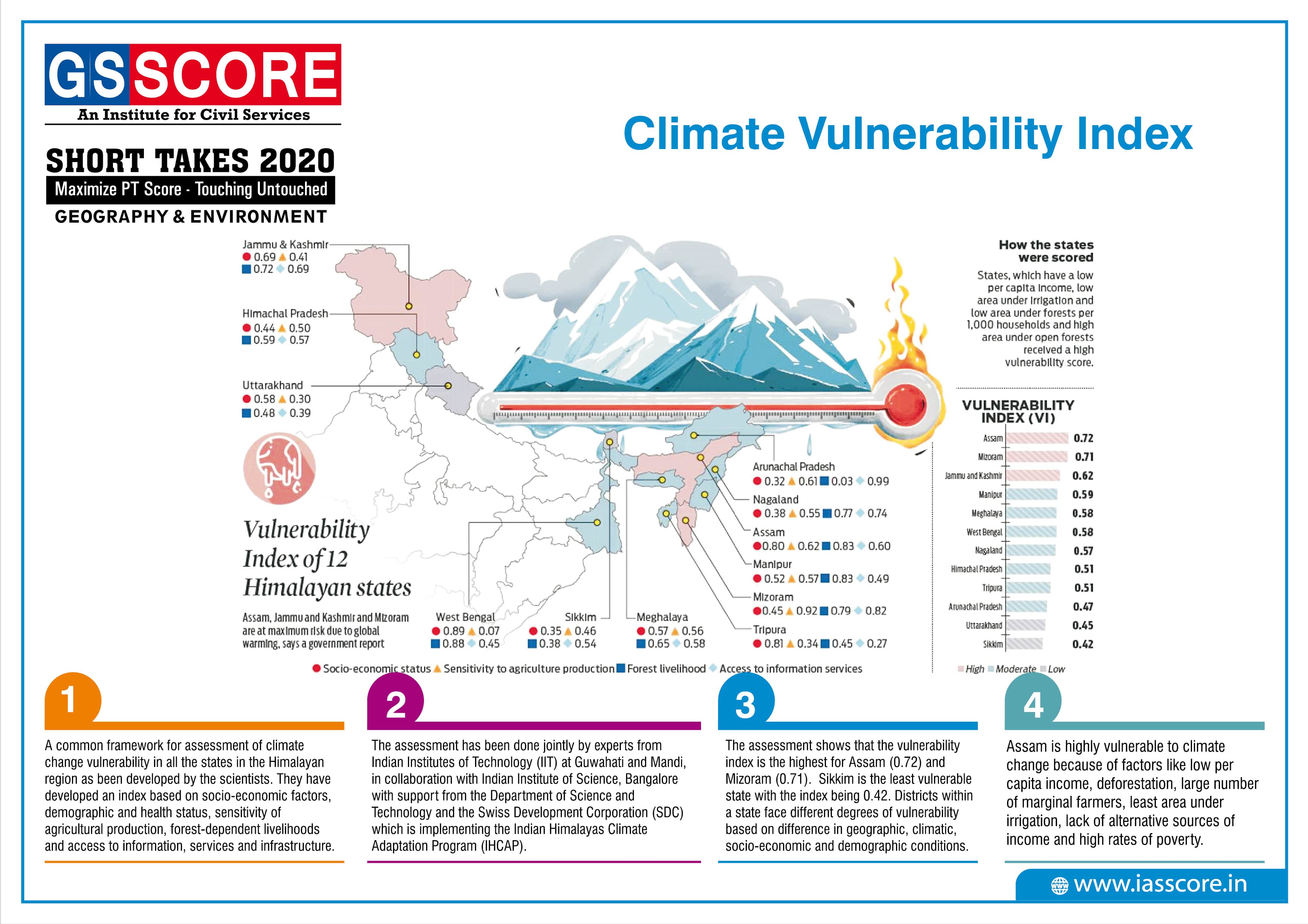
Climate Vulnerability Index
UN Environment Assembly

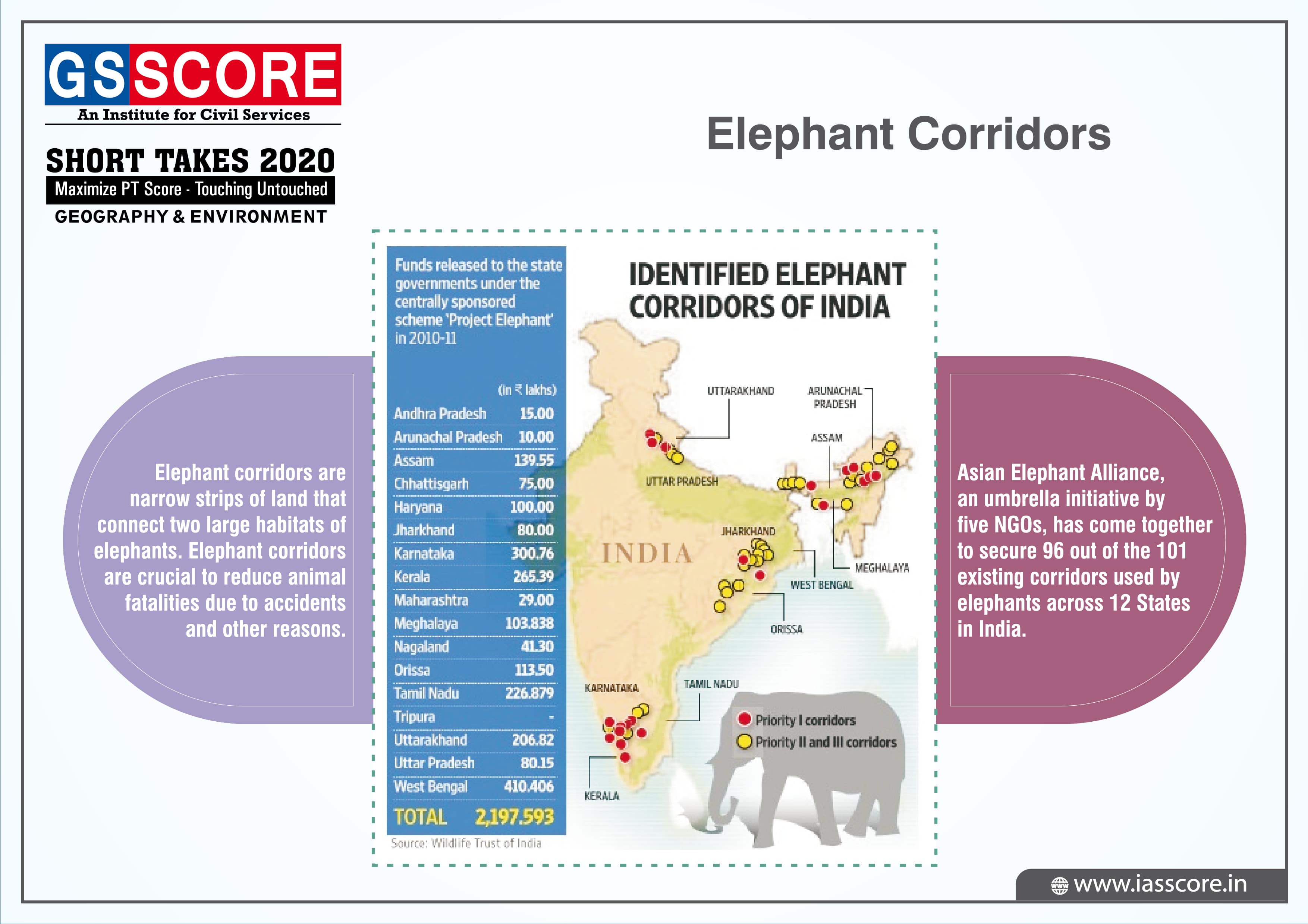
Elephant Corridors
Climate Change Performance Index (CCPI) 2019
_2019-min.jpg)