

21th July 2022 (7 Topics)
1
Jul
2
Jul
4
Jul
5
Jul
6
Jul
7
Jul
8
Jul
9
Jul
11
Jul
12
Jul
13
Jul
14
Jul
15
Jul
16
Jul
18
Jul
19
Jul
20
Jul
21
Jul
22
Jul
23
Jul
25
Jul
26
Jul
27
Jul
28
Jul
29
Jul
30
Jul
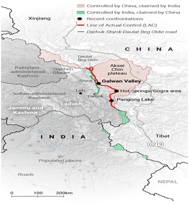
China to build highway close to Indian Territory in Aksai Chin
Context
China has planned to build another highway through Aksai Chin, connecting Xinjiang with Tibet, which is likely to run across the Indian border and reduce the distance from Doklam region.
Background
- The first time the government has acknowledged Chinese construction over the land since
- There were some temporary constructions few years back but now done permanent constructions in the region.
- Satellite images show the construction of a big village on the banks of Tsari Chu River in Upper Subansiri district between November 2019 and 2020.
- China continues to be in illegal occupation of approximately 38,000 sq. in the Union Territory of Ladakh, and Aksai Chin, and also claims approximately 90,000 sq. km. of Indian Territory in Arunachal Pradesh.
About
- G219’ will be the second national highway through the disputed Aksai Chin region, where China controls 38,000 sq km of land claimed by India.
- It is expected to be complete by
- The G695 national expressway is the only highway now that exists near Indian Territory build by China.
|
What is the Doklam Issue?
|
China’s strategic Plan
The Infrastructure development near LAC by China in recent past years have the following reasons:
- Mobilise its troops faster
- Infrastructural development
- Territorial expansion: The Bridge is in Chinese territory, and the Indian Army will have to now factor this in its operational plans.
- New border law
- China renamed 15 places in Arunachal Pradesh on its map
India’s Stand
- India-China Border Roads(ICBRs) is a Government of India project for developing infrastructure along the Sino-Indian border by constructing strategic roads, including bridges and tunnels.
- The ICBR project is largely in response to Chinese infrastructure development along the borderlands with India.
- As of May 2021, India is constructing at least 177 roads in two phases of over 10,023 km (6,228 mi) total length along its Line of Actual Control (LAC) with China under the "Border Infrastructure and Management Fund" (BIMF) of Ministry of Home Affairs.
- This includes 73 roads of 3,323 km (2,065 mi) length under ICBR-I (Phase-I) approved in 2005 and additional 104 roads of more than 6,700 km (4,200 mi) length under ICBR-II (Phase-II) approved in
|
Recent Developments by India near LAC
|
More Articles