

18th September 2024 (10 Topics)
2
Sep
3
Sep
4
Sep
5
Sep
6
Sep
7
Sep
9
Sep
10
Sep
11
Sep
12
Sep
13
Sep
14
Sep
16
Sep
17
Sep
18
Sep
19
Sep
20
Sep
21
Sep
23
Sep
24
Sep
25
Sep
26
Sep
27
Sep
28
Sep
30
Sep
Demchok and Depsang Friction Points
Context
There has been no progress towards resolution of two important friction points (Demchok and Depsang) in the past two years.
About Demchok and Depsang
- Depsang Plains
- The Depsang Plains are located close to the strategically important Daulat Beg Oldie.
- The crucial Sub-Sector North (SSN) consists of the Depsang plains and Daulat Beg Oldie (DBO). Currently, the airfield at DBO is accessible by the 255 km-long Darbuk-Shyok-DBO (DSDBO) road.
- In Depsang Plains, Chinese troops have been blocking Indian Army patrols from going up to the PPs 10, 11, 11A, 12 and 13, beyond the Y junction.
- Chinese build-up in this area threatens Indian positions at DBO and also brings Chinese troops closer to the DSDBO road.
- Depsang is also close to the Karakoram pass overlooking the strategic Saltoro ridge and Siachen glacier, the world’s highest battlefield.
- The Depsang Plains issue began in 2013 when China carried out an 18-km incursion in the area.
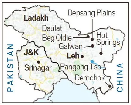
- Demchok
- Demchok is in the southern part of eastern Ladakh,
- In Demchok, the problem is mainly at the Charding Ninglung Nullah (CNN) junction.
Status of Disengagement
- Since the Corps commander-level talks in 2020, the two sides have so far undertaken disengagement from five friction points, from:
- Galwan
- North and South Banks of Pangong Tso
- Patrolling Point (PP) 17 in the Gogra-Hot Springs
- PP15
- Other points of concern:
- Chushul, located on the southern bank of Pangong Tso Lake, has an airstrip and is near Rezang La pass on the LAC.
- Spanggur Gap along the LAC has roads leading to it from either side. India’s Chushul-Demchok road in the area is a critical communication link.
- Samar Lungpa
- Trig Heights
- Chumar
- Dumchele
- Kongka La
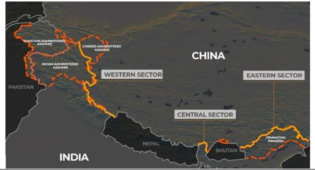
Fact Box: India-China Dispute
|
More Articles