
14th June 2023 (7 Topics)
Context
The monsoon is progressing under the cloud of an El Nino in the Pacific Ocean this year.
What is El Nino and La Nina phenomenon?
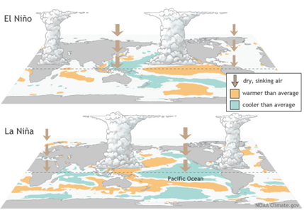
- El Nino refers to an abnormal warming of surface waters in equatorial Pacific Ocean.
- El Nino is known to suppress monsoon rainfall over India.
- La Nina is the abnormal cooling of sea surface waters in equatorial Pacific Ocean.
- La Nina is known to aid rainfall over India.

- La Nina is known to aid rainfall over India.
What is the Ocean-Atmosphere system?
- The oceans and the atmosphere are the two large reservoirs of water in the Earth's hydrologic cycle.
- The two systems are complexly linked to one another and are responsible for Earth's weather and climate.
- The oceans help to regulate temperature in the lower part of the atmosphere.
What is El Niño-Southern Oscillation (ENSO) phenomenon?
- The ENSO is a recurring climate pattern involving changes in the temperature of waters in the central and eastern tropical Pacific Ocean.
- ENSO actually is an interaction of ocean and atmospheric conditions.
- ENSO refers to a specific atmospheric condition that is a measure of the difference in sea-level air pressure over western and eastern side of the Pacific Ocean.
- ENSO is the strength and direction of winds.
- The abnormal warming or cooling of surface waters in Pacific Ocean does not result in an El Nino or La Nina event. The associated atmospheric conditions also have to be sync.kn
|
What is the El Niño-Southern Oscillation (ENSO) Neutral condition?
|
When does ENSO Neutral occur, and how does it affect the Indian Monsoon?
- The tropical regions, that is the area immediately above and below the equator, is home to a permanent wind system called trade winds that move from east to west at quite low altitudes.
- Because of the exposure to sunlight, the sea surface in the Pacific Ocean is quite warm. When the trade winds move over the Pacific Ocean, they push these relatively warm waters, which also become lighter, in the westward direction.
- So, the surface waters in the eastern Pacific Ocean that is near the South American coast get pushed towards the west. It is replaced by the relatively cooler waters from below.
- The warmer surface waters continue to get pushed till they encounter a landmass in the islands at Philippines and Indonesia. They cannot be pushed any further.
- The result of this process is the accumulation of relatively warm waters near Indonesia, called the Western Pacific Warm Pool, and relatively cold waters near Ecuador and Peru.
- This sweeping of surface waters and its accumulation also results in a relative rise in sea levels near Indonesia.
- The sea levels on the eastern coast of Indonesia happen to be about half a metre higher than the western coast of Ecuador and Peru.
- The warmer surface waters near Indonesia create a region of low-pressure area, causing the air to rise upwards. This also results in formation of clouds and heavy rainfall. The air flow also helps in building up the monsoon system which brings rainfall over India.
|


