
23rd August 2024 (8 Topics)
1
Aug
2
Aug
3
Aug
5
Aug
6
Aug
7
Aug
8
Aug
9
Aug
10
Aug
12
Aug
13
Aug
14
Aug
15
Aug
16
Aug
17
Aug
19
Aug
20
Aug
21
Aug
22
Aug
23
Aug
24
Aug
26
Aug
27
Aug
28
Aug
29
Aug
30
Aug
31
Aug
India launches first-ever survey of high-risk Glacial Lakes
Context
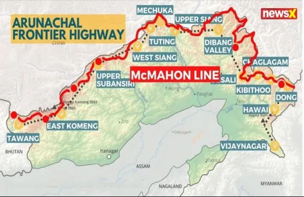
India has launched its first comprehensive survey of high-risk glacial lakes in Arunachal Pradesh’s Tawang and Dibang Valley districts. The move is part of initiatives undertaken by the National Disaster Management Authority after the glacial lake outburst flood in Sikkim’s South Lhonak lake in October last year.
About the Survey
- This initiative is part of the National Glacial Lake Outburst Flood (GLOF) Mission and led by the National Disaster Management Authority (NDMA).
- It aims to assess and mitigate risks associated with potential glacial lake outburst floods.
- The survey is designed to evaluate the risks posed by glacial lakes in Tawang and Dibang Valley. It will assess the feasibility of installing early warning systems and other mitigation measures to prevent potential flooding.
- Methodology: The survey includes evaluating accessibility, geocoordinates, lake boundaries, elevation, and land use patterns to facilitate the installation of Automatic Early Warning Systems and Automatic Weather Stations.
- Need for Glacial Lake Surveys
- Recent satellite data analyzed by ISRO revealed concerning trends: glacial lakes in the Indian Himalayas have been growing significantly.
- Between 1984 and 2023, many of these lakes have expanded in size, with 676 out of 2,431 lakes showing notable increases.
- Specifically, 130 of these expanding lakes are in India, with 65 in the Indus basin, 58 in the Brahmaputra basin, and 7 in the Ganga basin.
- For example, the Ghepang Ghat lake in Himachal Pradesh grew by 178% from 1989 to 2022, expanding at a rate of about 1.96 hectares per year.
- Studies highlight that GLOFs threaten around 15 million people worldwide, with those in the Himalayas being particularly at risk. Approximately one million people live near glacial lakes in this region, and the impacts of GLOFs can extend up to 120 km downstream.
- Issue: The survey's geopolitical significance is heightened due to the strategic location of Tawang and Dibang Valley near the India-China border, an area of historical tensions and concern regarding Chinese infrastructure projects in the region.
What is the Glacial Lake Outburst Flood (GLOF)?
- A Glacial Lake Outburst Flood (GLOF) occurs when a glacial lake’s natural dam (often formed by glacial debris or ice) suddenly fails, releasing a massive volume of water downstream.
- This sudden release can lead to catastrophic flooding, damaging infrastructure, ecosystems, and communities located downstream. GLOFs are particularly concerning in glaciated regions due to their potential for large-scale destruction.
- National Glacial Lake Outburst Floods Risk Mitigation Programme (NGRMP): The Centre has now approved the ?150-crore National Glacial Lake Outburst Floods Risk Mitigation Programme (NGRMP) on July 25.
- The programme aims at detailed technical hazard assessments, and installing automated weather and water level monitoring stations (AWWS) and early warning systems (EWS) at the lakes and in downstream areas.
- The primary objective of this programme is to attempt lake-lowering measures to reduce the risk of GLOF from such lakes.
Factors responsible for GLOF
- Glaciers in the Himalayas are shrinking very fast at the rate of 20 metre per year due to global warming. This increases the threat of a GLOF.
- Hydropower projects are being relentlessly commissioned in a region that is prone to seismicity, landslides, and climate change-related disasters.
Arunachal Pradesh’s Tawang and Dibang ValleyTawang:
Dibang Valley
Both districts are situated in areas claimed by China as part of southern Tibet.
|