
Published: 29th Jun, 2023
Context
A recent study revealed that, the piedmont zone of Haryana is actively deforming and could become a future seismic hazard zone.
Highlights of the study:
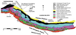
- Study-base: The study investigated the piedmont zone between the Ghaggar and Yamuna river basins in the frontal parts of the northwest Himalaya of Haryana.
- It focused on the piedmont alluvial plains and covered parts of Panchkula, Ambala and Yamunanagar districts in Haryana and Mohali district in Punjab.
- Findings:
- Active tectonic deformations: It found that there are signs of active tectonic deformations in the piedmont alluvial plains of northern Haryana.
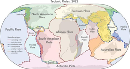
- Convergence: This was due to the convergence between the Indian tectonic plate and Eurasian plate resulted in the lifting of the Himalayan mountain belt.
- It also suggests an active deformation is propagating further south of the Himalayan front. These deformations may be reaching the 10- to 25-kilometre-wide piedmont zone of the Indo-Gangetic alluvial plains.
- Shortening of lithosphere: Along with the southward movement of the deformation front, the convergence also resulted in a significant shortening of the lithosphere.
- Tool used: Ground penetrating radar (GPR) surveys is an important tool ideally suited for obtaining high resolution profiles of the subsurface over a depth range of a few metres to several tens of metres.
|
Piedmont plains
|
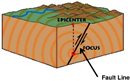
What is tectonic deformation?
- Crustal deformation refers to the changing earth's surface caused by tectonic forces that are accumulated in the crust and then cause earthquakes.
Ghaggar and Yamuna river basins:
- Rivers in Haryana fall mainly within Indus and Ganga basins.
- River Ghaggar sub basin and its tributaries in the west of the state caters to the Indus basin, while river Yamuna and its tributaries in the east make up the portion of the Ganga basin.
- The Ghaggar River:
- It rises in Shivalik hills in Solan district of Himachal Pradesh. It enters Haryana in Panchkula district.
- Hereafter the river flows making border between Punjab and Haryana for more than 100 Km.
- After Sirsa district the river leaves Haryana State and reaches Sri Ganga Nagar district, Rajasthan where after a certain length its course becomes untraceable.
- Once a perennial river, it is now seasonal at best. But during the monsoons, all its tributaries are found to be in flood.
|
Historical Significance: Rakhigarhi, ‘an Indus Valley site’ is close to navigable waterways of Sarasvati-Sindhu, Ganga-Yamuna-Brahmaputra and maritime routes of Persian Gulf. |
Geography Basics
|
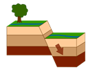
What is a fault?
|
|
|
How is a fault created?
|
|
|
Main Himalayan Thrust:
|
|
|
Plate tectonics
|
|