

Published: 3rd May, 2021
A series of earthquakes has hit Assam and major parts of the Northeast, causing extensive damage to the infrastructure.
Context
A series of earthquakes has hit Assam and major parts of the Northeast, causing extensive damage to the infrastructure.
Background
- The Indian Plate has produced three north-dipping fault systems stacked on each other.
- These faults in the Himalayas, namely Main Boundary Thrust (MBT), Main Central Thrust (MCT) and the Himalayan Frontal Thrust (HFT), run along the Himalayan Ranges.
- The precursice analysis of the earthquake in Assam shows that the events are located closer to Himalayan Frontal Thrust near Kopili Fault.
- This area isextreme seismically active which falls in the highest Seismic Hazard zone V associated with collisional tectonics where Indian plate sub-ducts beneath the Eurasian Plate.
Analysis
What is a fault?
- A fault is a fragmentation or zone of fractures between two blocks of rock. Faults allow the blocks to move relative to each other in different directions.
- This movement of blocks of rock can be rapid, in the form of an earthquake or may occur slowly, which is called as creep.
- Range of a fault can be few millimeters to thousands of kilometers. Most faults produce repeated displacements over geologic time.
- During the earthquake disaster, the rock on one side of the fault suddenly falls over with respect to the other.
- The fault surface can be vertical, horizontal or some arbitrary angle in between.
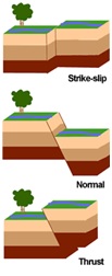
How is a fault created?
- A new fault is formed when the stress on the rock is great enough to cause a fracture, and one wall in the fracture moves relative to the other, which is caused by compressional/tensional force by the rising magma from the mantle.
Main Himalayan Thrust
- The Main Himalayan Thrust follows a North West-South East strike and is a décollement beneath the Himalaya Range, and gently dip towards the north, beneath the Himalayan region.
- MHT is the largest active continental mega-thrust fault in the world.
- Deformation of the crust is also accommodated along splay structures including the
- Himalayan Frontal Thrust (HFT)
- Main Boundary Thrust (MBT)
- Main Central Thrust (MCT)
Himalayan Thrust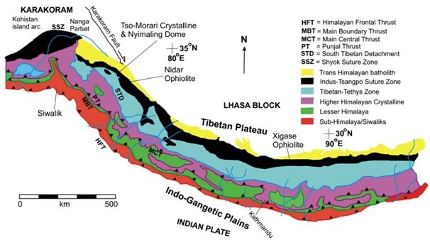
- Himalayan Frontal Thrust
- The Himalayan Frontal Thrust (HFT), also known as the Main Frontal Thrust (MFT) is a geological fault in the Himalayas that defines the boundary between the Indian and Eurasian Plates.
- The fault can be seen via satellite imagery because it is well expressed on the surface. The youngest and southernmost thrust structure in the Himalaya deformation front is Himalayan Frontal Thrust.
- As the root décollement, it is a splay branch of the Main Himalayan Thrust (MHT).
- Main Boundary Thrust
- Occurred during the Cainozoin period, the Main Boundary Thrust (MBT) is one of the major Himalayan thrusts, and it is presently incorporated within the Himalayan thrust wedge (Lesser and Outer Himalayas) displaced above the Indian lithosphere
- It shows the faulted contact between the Siwalik and the older Murree /Dharamshala beds in the Himalayas of Jammu-Himachal Pradesh.
- MBT has been described `unambiguously' as the southern limit of the Main Himalayan structural unitsin the Darjeeling Himalayas.
- The MBT is considered to be the thrust that transports older, Gondwana rocks from the north over the younger, Lower Siwalik rocks to the south.
- Main Central Thrust
- The Main Central Thrust is a major faultwhich is formed where the Indian Plate has pushed under the Eurasian Plate along the Himalaya. The fault is exposed on the surface in a NW-SE direction as it slopes down to the north. It is a 2200km longthrust fault that continues along Himalaya mountain belt.
What is seismic gap?
- A seismic gap a section of an active fault which has the potential to produce significant earthquake(s).
- The rocks at the gap have not slipped from their position, compared with other segments along the same structure in a long time.
- A hypothesis suggests that over along period of time, the displacement on any segment must be equal to the displacement experienced by all the other parts of the fault.
- Any large or longstanding gap in displacement is considered to be the fault segment most likely to suffer future earthquakes.
Three main seismic gaps in Himalayas
- Assam Gap: between the 1950 Assam and 1934 Bihar–Nepal earthquake ruptures, this has potential to cause at least three great earthquakes.
- Central Gap: between the 1905 Kangra and 1934 Bihar–Nepal earth-quakes, this has potential to cause three great earthquakes.
- Kashmir Gap: lies west of the1905Kangra earthquake rupture, this has potential to cause at least two great earthquakes.
Conclusion
Due to high population density, urbanization, deforestation and unprecedented growth of poor construction in the Himalayan foothills and Indo-Gangetic plains, scientists are of the view that even the occurrence of a single major earthquake will be disastrous for the region. Occurrence of a great magnitude earthquake any-where along the Himalayan arc can claim lives of up to 1 million people. Hence it is desirable to stress on the need of earthquake preparedness and enforcement of good construction practices. Seismological and GPS networks in the Himalaya should be installed other than the continuing efforts to understand the earthquake occurrence processes through, it is important that early earthquake warning systems be installed which may mitigate the risk in high population density regions in the Indo-Gangetic plains, ad-joining the Himalayan arc.