

Published: 13th Apr, 2023
Context
As per the information by private weather forecasting agency Skymet, India is likely to get "below normal" monsoon rains in 2023 with an increasing likelihood of El-Nino, which typically brings dry weather to Asia.
Highlights of the forecast:
- As per the agency, the likelihood of El Nino is increasing.
- El Nino return may affect the weather patterns and bring a weaker monsoon in India and parts of Asia, especially over the Indian Ocean region.
|
Measurement of Normal to average rainfall:
|
- Monsoon rains in India are expected to be 94% of the long-term average, retaining its previous view of sub-par monsoon.
- Skymet expects northern and central parts of the country to be at risk of being rain deficit.
- Punjab, Haryana, Rajasthan and Uttar Pradesh, are likely to observe less than normal rains during the second half of the season.
- The Indian Meteorological Department (IMD) also agreed to the news and is expected to announce its annual monsoon forecast soon.
The upcoming El Nino:
- The change in sea surface temperature associated with El Nino Southern Oscillation (ENSO) might seem marginal but is enough to disrupt weather patterns globally.
|
El Nino Southern Oscillation (ENSO):
|
- It can affect even the large-scale circulation of air in the polar stratosphere i.e. 8km above the Earth.
- The US National Oceanic and Atmospheric Administration (NOAA) has reported that the equatorial Pacific Ocean will return to its neutral state between March and May of 2023, and it is likely that El Niño conditions will develop during the northern hemisphere’s autumn and winter.
Concerns for India:
- Monsoon dependency: Nearly half of India's farmland, which has no irrigation cover, depends on annual June-September rains to grow crops such as rice, corn, cane, cotton and soybeans.
- Risk of Food Inflation: Unseasonal rains and hailstorms have damaged ripening, winter-planted crops such as wheat in India's fertile northern, central and western plains, exposing thousands of farmers to losses and raising the risk of further food price inflation.
|
About El Nino:
|
Conditions in the equatorial Pacific Ocean prior to the occurrence of El Niño:
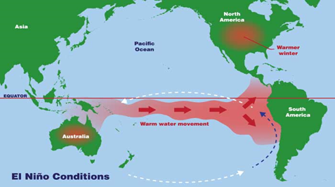
- The tropical pacific has consistent westerly moving trade winds. The trade winds push warm water on the surface of the ocean from east to west (westerly).
- This causes warm water to build upon the western side of the ocean near Asia.
- Meanwhile, on the eastern side of the ocean, near Central and South America, cold waters are pushed up towards the surface.
- Because of this, there is a difference in temperature across the equatorial pacific, with warm water to the west and cold water to the east.
- The warm water in the west heats the air, making the warm air rise and leading to drastic weather, including rain and thunderstorms.
- The rising warm air causes a circulation between east and west in the Pacific, with the warm, moist air rising in the west, and cool, dry air descending in the east.
- All of these natural occurrences lead to a reinforcement of the easterly winds and cause a self-perpetuating motion in the air in the Pacific.
Possible Consequences globally:
- Likely to exceed 5°C above the target of the Paris agreement:
- During the process of ENSO, the rise and cooling process of seawater is simultaneous, however, the rise for a prolonged period can make significant changes in the upper atmosphere.
- El Niño adds some extra heat to the atmosphere and is estimated can exceed to the 1.5°C threshold of the Paris agreement.
- On the Australian coast:
- During El Niño, scientists expect less rain, higher temperatures and increased fire risk, especially during winter and spring in the southern hemisphere.
- As the globe heats up, some regions are warming faster than others. Australia can become 1.4°C hotter now than in the early 20th century.
- In South America:
- South American weather is significantly disrupted every time an El Niño event occurs;
- flooding on the west coasts of Peru and Ecuador and
- Drought in the Amazon and northeast, where the consequences of crop failures can reverberate across the continent.
- Disease outbreak: During El Niño events, due to fall in precipitation and rise in temperature in Colombia, is linked to outbreaks of diseases spread by insects, such as malaria and dengue fever.
- Higher temperatures during El Niño boost the rates at which mosquitoes breed and bite.
- Less carbon intake: Later on, the Amazon rainforest dries and vegetation growth slowsso that less CO2 is absorbed from the atmosphere, a trend repeated in the tropical forests of Africa, India and Australia.
- In Northern Europe:
- The balance between high pressure over the Azores and low pressure over Iceland determines where the rain goes in Europe during winter by pushing the jet stream.
- During El Niño winters, both pressure centres lose strength, and the jet stream brings wetter conditions to southern Europe.