

20th May 2022 (6 Topics)
2
May
3
May
4
May
5
May
6
May
7
May
9
May
10
May
11
May
12
May
13
May
14
May
16
May
17
May
18
May
19
May
20
May
21
May
23
May
24
May
25
May
26
May
27
May
28
May
30
May
31
May
Pangong Bridge Construction Is In‘OCCUPIED TERRITORY’
Context
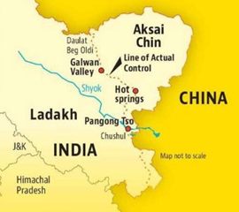
Ministry of External Affairs (MEA) recently said that India is closely monitoring the construction of a bridge by China on the Pangong Tso (lake) in eastern Ladakh, which is in “occupied territory”.
About
About:
- The construction of the main bridge had just commenced and the small bridge, of which satellite images had come out in January, was not a “permanent bridge” but a bailey bridge to support the construction of the main one.
Where Is The Bridge Coming Up?
- The bridge is coming up near the Khurnak Fort, at one of the narrowest points of the 134-km-long Pangong Lake.
- China occupied the area around Khurnak Fort in June 1958. In the 1962 war, China expanded its control to the Sirijap Complex, further west of the Khurnak Fort.
- During the war, India had posts at Sirijap while the Chinese had a base at Khurnak.
- The 'Fingers' area, occupied by Chinese forces in May 2020, leading to the standoff that continues at some places in eastern Ladakh, is further west of the Sirijap Complex.
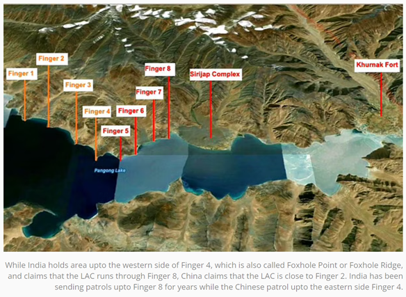
Claims of both countries:
- India controls the area upto the western side of Finger 4, which is also called Foxhole Point or Foxhole Ridge, and claims that the LAC runs east of Finger 8.
- China claims that the LAC is close to Finger 2.
- The PLA has a strong presence both north and south of Pangong Lake.
- On the north bank, it has large bases at Khurnak and Sirijap.
- Just south of the lake, it has bases on the bank of the Spanggur Lake.
- The Indian Army has a permanent position near Finger 3, the Dhan Singh Thapa post.
- The south bank leads to the Kailash range and to the Chushul sector.
- The Kailash Range, on which the Indian Army occupied tactically important heights in August 2020, is located just west of Spanggur Lake.
The recent standoff:
- Standoff:
- Before the standoff that began in May 2020, Indian patrols went upto Finger 8, and the Chinese patrolled the area upto the eastern side of Finger 4.
- During the standoff, the Chinese, who had a base just east of Finger 8, occupied the area between Finger 8 and the eastern side of Finger 4, blocking India from accessing the area.
- Disengagement deal:
- As part of the disengagement deal reached in January-February 2021, the Chinese dismantled the posts they had built between Finger 8 and Finger 4 and moved back to their traditional base east of Finger 8.
- Indian troops, who had taken up new positions in response to China's occupation, went back to their Dhan Singh Thapa Post, just west of Finger 3.
- A no-patrol zone was set up between Finger 3 and Finger 8.
How would it help China?
- China has a major base in the Rutog area which is taking care of both the southern and northern banks of Pangong Tso lake.
- Reduction in distance: Earlier, they had to take a detour encircling the lake to reach the northern bank of Pangong Tso from Rutog. But with the construction of this bridge, they would be able to reduce the distance from Rutog to Khurnak by 120-130 Km or 3 days.
- Easy troop movement: It would also facilitate easy troop movement between both the banks of the lake.
- Multiple routes: A fully constructed bridge means China will have multiple routes to add troops in the contentious area.
|
Pangong Tso lake
|
More Articles