

28th May 2024 (11 Topics)
1
May
2
May
3
May
4
May
6
May
7
May
8
May
9
May
10
May
11
May
13
May
14
May
15
May
16
May
17
May
18
May
20
May
21
May
22
May
23
May
24
May
25
May
27
May
28
May
29
May
30
May
31
May
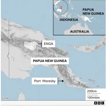
Papua New Guinea Landslide
Context
A devastating landslide in Papua New Guinea’s Enga province has potentially buried over 2,000 people. This catastrophic event at Mount Mungalo highlights the destructive power of landslides and the challenges in predicting them.
Causes of Landslides
- Landslides occur when gravity's pull exceeds the strength of the materials making up a slope. These materials can include rocks, sand, silt, and clay. When a slope fails, the resulting landslide can vary greatly in size, from a few cubic meters to millions.
- Natural Triggers:
- Earthquakes: Ground shaking from earthquakes can stress and weaken slopes.
- Rainfall: Heavy rain can saturate the ground, adding weight to the slope and causing it to fail. Papua New Guinea is especially prone to landslides due to its active fault lines and heavy rainfall.
- Water's Role in Landslides:
- Erosion: Constant wave action can erode coastal slopes.
- Groundwater: Water can dissolve rocks within slopes, reducing their stability.
- Human Triggers:
- Deforestation: Removing trees weakens slopes, as tree roots help stabilize the ground and drain water.
- Mining Activities: Blasts from mining can create vibrations similar to small earthquakes, destabilizing nearby slopes.
Challenges in Predicting Landslides
- Multiple Factors: Effective prediction requires knowledge of potential triggers like earthquakes and rainfall, as well as the properties of the slope materials.
- Complex Geomaterials: Slopes often contain varied layers of rock and soil with different strengths. Mapping these materials in three dimensions is currently impossible with existing technology.
- Partial Information: Geologists and engineers work with limited data from a few locations and must extrapolate this to predict slope stability, often missing critical weak points.
- Runout Distance: The larger the landslide, the farther it travels. However, predicting the exact size and impact area remains uncertain.
- Timing: Predicting the precise timing of landslides is as challenging as forecasting the weather or seismic activity.
Fact Box:Landslide Prone Regions in India
Government initiatives to mitigate the risk of landslides
|
||||||||||||
PYQ
|