
Published: 7th May, 2022
Context
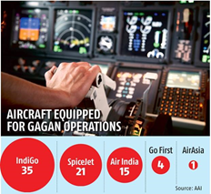
India achieved a major landmark when the Airports Authority of India (AAI) successfully conducted a trial applied the latest technology developed by an indigenous satellite based augmentation system (SBAS) called GAGAN (GPS Aided GEO Augmented Navigation) at the Kishangarh airport in Rajasthan.
- The IndiGo aircraft flew an aircraft with an Instrument Approach Procedure (IAP) with LPV minima of 250ft, using GAGAN Service.
- India is the first country in Asia Pacific Region to achieve this.
About
What is GPS Aided GEO Augmented Navigation (GAGAN)?
- It is a Satellite Based Augmentation System (SBAS) implemented jointly with Airport Authority of India (AAI).
- The main objectives of GAGAN are to provide Satellite-based Navigation services with accuracy and integrity required for civil aviation applications and to provide better Air Traffic Management over Indian Airspace.
- The system will be interoperable with other international SBAS systems and provide seamless navigation across regional boundaries.
- The GAGAN Signal-In-Space (SIS) is available through GSAT-8 and GSAT-10.
- GAGAN is used to provide lateral and vertical guidance when an aircraft is approaching a runway for landing.
- Its precision is especially useful at small airports where the instrument landing system (ILS) has not been installed.
- In India's civil aviation sector, GAGAN will modernise the airspace, reduce flight delays, save fuel and improve flight safety.
|
Satellite Based Augmentation System (SBAS)
|
Some of the benefits GAGAN is expected to bring for Civil Aviation sector are:
- Safety benefits – Vertical guidance improves safety, especially in adverse weather conditions
- Reduction of circling approaches
- Environmental benefits–Approach with Vertical Guidance procedures will help facilitate better energy and descent profile management during the final approach
- Global seamless navigation for all phases of flight including arrival, departure, oceanic and en route
- Allow direct routings, multiple approaches resulting in considerable fuel savings to airlines and provide for capacity enhancement of airports and airspace