

Published: 25th May, 2019
The RISAT-2B satellite, launched by the Indian Space Research Organisation (ISRO), adds to India’s capability to observe the earth in all weathers and all conditions. It is a newest microwave Earth observation satellite.
Context
The RISAT-2B satellite, launched by the Indian Space Research Organisation (ISRO), adds to India’s capability to observe the earth in all weathers and all conditions. It is a newest microwave Earth observation satellite.
About
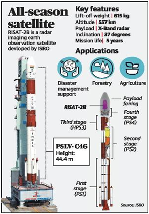
- The RISAT is equipped with a sensor known as ‘synthetic aperture radar’, which takes what are known as ‘radar images’.
- It is equipped with an active sensor, the synthetic aperture radar (SAR), which can sense or ‘observe’ Earth in a special way from space day and night, rain or cloud. This all-weather seeing feature is what makes it special for security forces and disaster relief agencies.
- The SAR send out hundreds of radio signals every second towards the subject (in this case, the earth) and capture the reflected signals to create a radio image, which can then be used by computers to build a real image.
- RISAT-2B was recently launched from Sriharikota and this marked the resumption of a vital ring of Indian all-seeing radar imaging satellites after seven years.
Two satellites in RISAT series have earlier been launched by ISRO. RISAT-2 was the first one to be launched, in 2009, while RISAT-1, which had got delayed, was launched only in 2012. RISAT-1 is no longer operational.
Benefits
- It sends much heavier data than plain remote sensing satellites.
- This satellite picks up structures, new bunkers very well, and sometimes helps to count them, too.
- In India, this will be used for crop estimation because main crop growing season of kharif is in May-September when it rains and gets cloudy. This data is extensively used for forestry, soil, land use, geology and during floods and cyclone. So it can be used for applications in agriculture, forestry and disaster management support.
Way Ahead
- At least a half-dozen could be foreseen in the near future, mainly to add to the reconnaissance capability from about 500 km in space. A constellation of such space-based radars means a comprehensive vigil over the country.
- Services of such satellites are also in great demand from national security agencies as well.