Geography: Climatology Part I
Climatology Part-I
EARTH’S ATMOSPHERE
- Earth’s atmosphere is a critical system for life on our planet. Atmosphere is a gaseous envelope extending thousands of kilometers above the earth’s surface. Much of the life on the earth exists at the bottom of the atmosphere where it meets the lithosphere and the hydrosphere.
- The atmosphere is held to the earth by its gravitational force and is energized by the sun. But Earth’s climate is not static.
- Many atmospheric processes take place in a state of dynamic balance —for example; there is an average balance between the heat input to, and output from, the atmosphere.
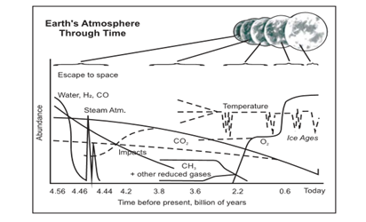
Evolution of Earth’s Atmosphere
- In the first 500 million years, a dense atmosphere emerged from the vapor and gases that were expelled during degassing of the planet’s interior. These gases may have consisted of Hydrogen (H2), water vapor, Methane (CH4), and Carbon Oxides.
- The hydrosphere was formed 4 billion years ago from the condensation of water vapor, resulting in oceans of water in which sedimentation occurred.
- The most important feature of the ancient environment was the absence of free oxygen. One billion years ago, early aquatic organisms called blue-green algae began using energy from the Sun to split molecules of H2O and CO2 and recombine them into organic compounds and molecular oxygen (O2). This solar energy conversion process is known as photosynthesis.
- Some of the photosynthetically created oxygen combined with organic carbon to recreate CO2 The remaining oxygen accumulated in the atmosphere, touching of a massive ecological disaster with respect to early existing anaerobic organisms. As oxygen in the atmosphere increased, CO2 decreased.
Composition of the Atmosphere
- The atmosphere is a mixture of many gases, water vapour and dust particles. It also contains huge amount of solid and liquid particles collectively known as “aerosols”. Pure dry air consists mainly of Nitrogen, Oxygen, Argon, and Carbon dioxide, Hydrogen, Helium and Ozone. Besides, water vapour, dust particles, smoke, salts are also present in air in varying quantities. The composition of atmosphere upto an altitude of about 90 km is uniform in terms of three major gases - Nitrogen, Oxygen and Argon. This layer is generally, called homosphere. Above 90 km, the composition begins to change with progressive increase in the lighter gases. This layer is known as heterosphere.
Gases
- Nitrogen and Oxygen comprise 99% of the total volume of the atmosphere. But they are climatically of little consequences. Nitrogen doesn’t easily enter into chemical union with other substances but gets fixed into the soil. It serves mainly as diluents and regulates combustion.
- It is available to the organisms through plants. Plants convert the nitrogen into various usable forms through the process of nitrogen fixation. Various industries like fertilizer industries, explosive industries, etc. use the nitrogen available in atmosphere as raw material. So, it is of great biological and economical importance.
- Oxygen combines with all the elements and is most combustible.
- Carbon dioxide constitutes a small percentage of the atmosphere. It is transparent to the incoming shortwave but is capable of trapping long wave solar radiation. It can absorb heat and allow the lower atmosphere to be warmed up by heat radiation coming from the sun and from the earth’s surface. It is largely responsible for the greenhouse effect.
- However increase in its concentration culminates to rise in temperature thus global warming.
- It is equally important in supporting the life as well as deterring it. CO2 is found in the atmosphere as free gas as well as in the dissolved from.
Water Vapour
- Water vapor is a variable factor which ranges from 0 to 4% depending on various factors of the region like, atmospheric circulation of wind, temperature, supply of moisture, vegetation, concentration of population, and human activities, etc. Water vapour controls to a great extent the climatic condition of the area. Temperature is the primary factor which controls the presence of water vapour. So, it goes on decreasing towards the pole from equator. It’s concentration is in the lower strata of the atmosphere upto the height of 5 km. The moisture content of the atmosphere creates several forms of condensation and precipitation e.g. clouds, fogs, dew, rainfall, frost, hailstorm, ice, snowfall, etc.
Particulate Matter
- The particulate matters present in the atmosphere includes dust particles, salt particles, pollen, smoke and soot, volcanic ashes, etc. They are kept in suspension in the atmosphere. When the smoke is mixed with the fog it forms smog. It persists in the atmosphere for longer time than the fog and reduces the visibility of the region to a great extent, sometimes even to few metres bringing the traffics to a standstill and is responsible for fatal accidents. They are the main cause of haze formation.
Structure of the Atmosphere
- About 50% of the atmosphere is confined to 5.6 km and 97% upto 29km. The upper limit of atmosphere is considered to be 10,000 km from sea level. On the basis of characteristic of temperature and pressure there are layers of atmosphere.
Troposphere
- It is lower most layer of the atmosphere. Temperature decreases with the increase in height at the rate of 6.5°C per 1000 m in this layer, called as normal lapse rate.
- The upper limit of the troposphere decreases from equator towards the pole.
- The average height of the troposphere is about 16 km over the equator and 6 km over the Poles. The upper limit is called as “tropopause”, which is about 1.5 km thick.
- Troposphere is the most important layer of the atmosphere as all the weather phenomena like fog, cloud, dew, frost, rainfall, hailstorm, cloud thunder, etc occurs in this layer. It is apparent from this that the troposphere is the life supporting layer of the atmosphere which circulates various cycles like, hydrological cycle, oxygen cycle, carbon cycle, etc.
Stratosphere
- This layer is just above the troposphere; on an average stratosphere is 50 km high. The temperature in this layer gradually rises upward and is about 0°C at the stratopause, the upper limit of stratosphere. In the lower part of stratosphere there is ozone layer between the heights of 15 to 30 km. This part is called as ozonosphere. Ozone (O3) is a 3 atom isotope of oxygen. It is very important for the life forms on the earth as it absorbs high energy ultra violet radiations from the sun. If the U-V rays reach the earth’s surface it will increase the temperature of the earth unexpectedly because of the high energy it has. It then causes the skin cancers in the fair complex human being and various other dermatological diseases in the living organisms. It is because of the absorption of this high energy radiation that the stratosphere is hotter than the layer above and below it.
Mesosphere
- This layer extends between 50 km and 80 km. Temperature again starts decreasing with increase in height in this layer. This is because this layer is being heated from below. The ozonosphere present in the stratosphere provides the heat. The upper most limit of mesosphere is 80 km where the temperature becomes - 80°C, and is called as mesopause. This is the height from where the air in the atmosphere starts inducing some frictional resistance on any moving object. When the meteors, which are also known as shooting stars enters the mesosphere, they get heated due to the frictional resistance experienced by them due to air.
Thermosphere
- In this layer the temperature increases rapidly with increase in height. It is divided in two different layers. Ionosphere extends from 80 km to 640 km. Here the elements are found in the form of free ions that is why it is called as ionosphere. Now days, it has become an important source of income for government, which taxes and auctions it for exploitation. It has revolutionized the modes of communication because it is less costly and more efficient than the fixed lines.
Exosphere
- It represents the upper most layer of the atmosphere. It extends beyond 640 km and gradually merges with the outer space. We know very little about it.
SOLAR RADIATION TEMPERATURE & HEAT BALANCE
Weather & Climate
Temperature, pressure, wind, humidity and precipitation, interact with each other. They influence the atmospheric conditions like the direction and velocity of wind, amount of insolation, cloud-cover and the amount of precipitation. These are known as the elements of both weather and climate.
- Weather is the atmospheric condition of a place for a short duration with respect to its one or more elements.
- Whereas the average weather conditions, prevalent from one season to another in the course of a year, over a large area is known as climate.
Factors Affecting Climate
- Latitude or Distance from the Equator: The places near the equator are warmer than the places which are far away from it. This is because the rays of the sun fall vertical on the equator and slanting in the temperate and polar regions. Therefore, lower the latitude higher is the temperature and vice versa.
- Altitude or the Height from the mean sea level: The temperature decreases with increase in height as atmosphere is heated from below.
- Continentality or the Distance from the Sea: The water is a bad conductor of heat i.e. It takes longer time to heat and longer time to cool. Due to this moderating effect of the sea, places near the coast have low range of temperature and high humidity. The places in the interior of the continent do not experience moderating effect of the sea. These places have extreme temperatures. Mumbai has relatively lower temperature and higher rainfall than Nagpur, although both are almost situated on the same latitude.
- Nature of the Prevailing Winds: The on-shore winds bring the moisture from the sea and cause rainfall on the area through which they pass. The of -shore winds coming from the land are dry and help in evaporation. In India, the on-shore summer monsoon winds bring rains while of -shore winter monsoon winds are generally dry.
- Cloud Cover: In areas generally of cloudless sky as in deserts, temperature even under shade is very high because of the hot day time sunshine. At night this heat radiates back from the ground very rapidly. It results in a large diurnal range in temperature. On the other hand under cloudy sky and heavy rainfall at Thiruvananthapuram the range of temperature is very small.
- Ocean Currents: Ocean waters move from one place to another partly as an attempt to equalize temperature and density of water. The warm ocean currents raise the temperature of the coast and sometimes bring rainfall, while the cold currents lower the temperature and create fog near the coast. Port Bergen in Norway is free from ice even in winter due to warm North Atlantic Drift while Port Quebec in Canada remains frozen during winter months due to chilling effect of the Cold Labrador Current in spite of the fact that Port Quebec is situated in much lower latitude than Port Bergen.
- Direction of Mountain Chains: The mountain chains act as natural barrier for the wind. The on-shore moisture laden winds are forced to rise after striking against the mountain; and give heavy rainfall on the windward side. These winds descending on the leeward side cause very low rainfall. The great Himalayas check the moisture laden monsoon winds from crossing over to Tibet. This mountain chain also checks biting polar cold winds from entering into India. This is the reason for which northern plains of India get rains while Tibet remains a perpetual rain shadow area with lesser amount of rainfall.
- Slope: The concentration of heat being more on the gentler slope raises the temperature of air above them. Its lesser concentration along steeper slopes lowers the temperature. At the same time, mountain slopes facing the sun are warmer than the slopes which are away from the sun’s rays. The southern slopes of Himalaya are warmer than the northern slopes.
- The Nature of the Soil and Vegetation Cover: The nature of soil depends upon its texture, structure and composition. These, qualities vary from soil to soil.
Solar Radiation
- The earth’s surface receives most of its energy in short wavelengths. The energy received by the earth is known as incoming solar radiation which in short is termed as insolation.
- As the earth is a geoid resembling a sphere, the sun’s rays fall obliquely at the top of the atmosphere and the earth intercepts a very small portion of the sun’s energy.
- On an average the earth receives 1.94 calories per sq. cm per minute at the top of its atmosphere.
- The solar output received at the top of the atmosphere varies slightly in a year due to the variations in the distance between the earth and the sun. During its revolution around the sun, the earth is farthest from the sun (152 million km) on 4th July. This position of the earth is called aphelion. On 3rd January, the earth is the nearest to the sun (147 million km). This position is called perihelion. Therefore, the annual insolation received by the earth on 3rd January is slightly more than the amount received on 4th July.
- However, the effect of this variation in the solar output is masked by other factors like the distribution of land and sea and the atmospheric circulation. Hence, this variation in the solar output does not have great effect on daily weather changes on the surface of the earth.
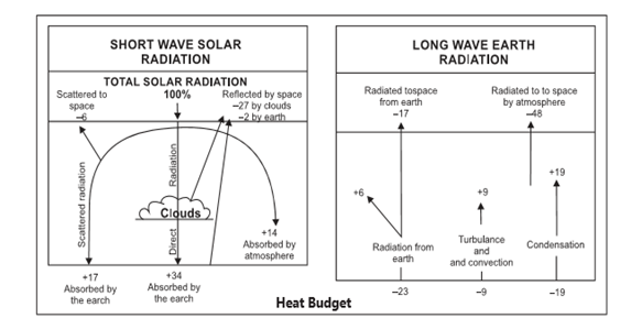
Heat Budget
- The Earth’s climate is a solar powered system. The earth as a whole does not accumulate or loose heat. It maintains its temperature. This can happen only if the amount of heat received in the form of insolation equals the amount lost by the earth through terrestrial radiation.
- Although the earth and its atmosphere as a whole have a radiation balance, there are latitudinal variations. The heat/energy is transferred from the lower latitudes to the higher latitudes through winds and ocean currents. In the low latitudes (between 40°N and 40°S) heat gained by short wave radiation is far more than the heat loss by long waves through the earth’s radiation.
- In contrast in the higher latitudes more heat is lost by outgoing long wave than it is received in short waves. In view of the imbalances at high and low latitudes, there is large- scale transfer of heat from tropics to high latitudes by atmospheric and oceanic circulation.
- The absorption of outgoing thermal infrared by carbon dioxide means that Earth still absorbs about 70 per cent of the incoming solar energy, but an equivalent amount of heat is no longer leaving. The exact amount of the energy imbalance is very hard to measure, but it appears to be a little over 0.8 watts per square meter.
Inversion of Temperature
Normally, temperature decreases with increase in elevation. It is called normal lapse rate. At times, the situation is reversed and the normal lapse rate is inverted. It is called Inversion of temperature. Inversion is usually of short duration but quite common nonetheless.
Types of Temperature Inversion
Ground Surface Inversion
- Ground surface inversion also called as radiation inversion occurs near the earth’s surface due to radiation mechanisms. This is also called as non advection inversion because it occurs in states atmospheric condition characterized by no movement of air whether horizontal or vertical. The ground surface inversion occurs under the following conditions:
- Long winter nights so that the loss of heat by terrestrial radiation from the ground surface during night may exceed the amount of insolation received.
- Cloudless and clear sky so that the loss of heat through terrestrial radiation proceeds more rapidly without any obstruction. Clouds absorb terrestrial radiation and hence loss of heat from the earth’s surface.
- Presence of dry air near the ground surface, so that it may not absorb much heart radiated from the earth’s surface as moist air is capable of absorbing much of the radiant heat from the earth’s surface.
- Slow movement of air, so that there is no transfer and mixing of heat in the lower layers of the atmosphere. Snow covered ground surface, so that there is maximum reflection of incoming solar radiation.
- Snow, being bad conductor of heat regards the flow of heat from the ground surface lying below the snow layers to the lower atmosphere.
- This inversion promotes stability in the lower portion of the atmosphere and causes dense fogs.
Upper Air Inversion
- Upper air inversion is of two type’s viz. (i) thermal upper air inversion and (ii) mechanical upper air inversion.
- The thermal upper air inversion is caused by the presence of ozone layer lying between the heights of 15 to 35 km (even up to 80 km) in the stratosphere.
- The mechanical inversion of temperature is caused at higher heights in the atmosphere due to subsidence of air and turbulence and convertible mechanisms. Mechanical inversion caused by the subsidence of air currents is generally associated with the anticyclones conditions. This type of inversion of temperature is very common in the middle latitude where high pressures are characterized by sinking air.
- The pole wards regions of the winds are also characterized by high pressure caused by the subsidence of air resulting into mechanical inversion of temperature.
- The temperature inversion causes stability in the atmosphere. This is the reason that the poleward parts of trade winds are characterized by arid conditions.
Advection Inversion of Temperature
- Advection Inversion of Temperature is associated with the dynamism of the atmosphere. Strong wind movement and unstable conditions of the atmosphere are prerequisite conditions for advection inversion of temperature.
Frontal or Cyclonic Inversion
- Frontal or Cyclonic inversion is caused in the temperate zones due to temperate cyclones which are formed due to the convergence of warm western lies and cold polar winds in the northern hemisphere. The existence of warm air above and cold air below reverse the normal lapse rate and inversion of temperature occurs.
Surface Inversion
- Surface inversion of temperature is caused horizontal movement of air. It is caused when warm air invades the area of cold air or cold air moves into the area of warm. Cold air being denser settles down in both the case resulting into temperature inversion. The convergence of cold and warm ocean currents also causes surface inversion of temperature.
Valley Inversion
- Valley inversion generally occurs in the mountainous valleys due to radiation and vertical movement of air.
- The temperature of the upper parts of the valleys in mountainous areas becomes exceedingly low during winter nights because of rapid rate of loss of heat from the surface through terrestrial radiation. Consequently, the air coming in contact, which the cool surface also becomes cool .
- On the other hand, the temperature of the valley floor does not fall considerably because of comparatively low rate of loss of heat through terrestrial radiation. Thus, there is warm air aloft and cold air in the valley floor and inversion of temperature is caused.
- This situation is responsible for severe frost in the valley floors causing great damage to fruit orchards and vegetables and agricultural crops whereas the upper parts of the valleys are free from front. This is why the valley floors are avoided for human settlements while the upper parts inhabited in the mountainous valleys of middle latitudes.
Significance of Inversion of Temperature
Some of the most significant consequences of temperature inversions are the extreme weather conditions they can sometimes create. One example of these is freezing rain. This phenomenon develops with a temperature inversion in a cold area because snow melts as it moves through the warm inversion layer.
- Intense thunderstorms and tornadoes are also associated with inversions because of the intense energy that is released after an inversion blocks an area’s normal convection patterns.
- Although freezing rain, thunderstorms, and tornadoes are significant weather events, one of the most important things impacted by an inversion layer is smog. Smog is impacted by the inversion layer because it is in essence, capped, when the warm air mass moves over an area.
- Inversion of temperature causes frost when the condensation of warm air due to its cooling by cold air below occurs at temperature below freezing point. Frost is definitely economically unfavorable weather phenomenon mainly for crops because fruit orchards and several agricultural crops such as potatoes, tomatoes peas etc. are totally damaged overnight.
- Inversion of temperature causes atmosphere stability which stops upward (ascent) and downward (descent) movements of air. The atmosphere stability discourages rainfall and favors dry condition.
- The inversion of temperature caused by the subsidence of air resulting into anticyclones conditions increases aridity . This is why the western parts of the continents situated between 200-300 latitudes and characterized by anticyclones condition represent most widespread tropical deserts of the world.
ATMOSPHERIC HUMIDITY & RAINFALL
Condensation
- Condensation is the process by which atmospheric water vapour changes into water or ice crystals. It is just reverse of the process of evaporation. When the temperature of saturated air falls below dew point, the air cannot hold the amount of humidity which it was holding earlier at a higher temperature. This extra amount of humidity changes into water droplets or crystals of ice depending upon the temperature at which condensation takes place.
- The temperature of the air falls in two ways. Firstly, cooling occurs around very small particles of freely floating air when it comes in contact with some colder object. Secondly, loss in air temperature takes place on a massive scale due to rising of air to higher altitudes.
- The condensation takes place around the smoke, salt and dust particles which attract water vapour to condense around them. They are called hygroscopic nuclei. When the relative humidity of an air is high, a slight cooling is required to bring the temperature down below dew point.
- But when the relative humidity is low and the temperature of the air is high, a lot of cooling of the air will be necessary to bring the temperature down below dew point. Thus, condensation is directly related to the relative humidity and the rate of cooling.
- Condensation takes place in two situations, firstly, when dew point is below freezing point or below 0°C and secondly, when it is above freezing point. In this way, the forms of condensation may be classified into two groups:
- Frost, snow and some clouds are formed when dew point is below freezing point.
- Dew, mist, fog, smog and some clouds are formed when dew point is above freezing point
- The forms of condensation may also be classified on the basis of place where it is occurring, for example, on the ground or natural objects such as grass blades and leaves of the plants or trees, in the air close to the earth’s surface or at some height in the troposphere.
- Dew: When the atmospheric moisture is condensed and deposited in the form of water droplets on cooler surface of solid objects such as grass blades, leaves of plants and trees and stones, it is termed as dew. Condensation in dew form occurs when there is clear sky, little or no wind, high relative humidity and cold long nights. These conditions lead to greater terrestrial radiation and the solid objects become cold enough to bring the temperature of air down below dew point. In this process the extra moisture of the air gets deposited on these objects. Dew is formed when dew point is above freezing point.
- Frost: When the dew point is below freezing point, under above mentioned conditions, the condensation of extra moisture takes place in the form of very minute particles of ice crystals. It is called frost. In this process, the air moisture condenses directly in the form of tiny crystal of ice. This form of condensation is disastrous for standing crops such as potato, peas, pulses, grams, etc. It also creates problems for road transport system.
- Mist and Fog: When condensation takes place in the air near the earth’s surface in the form of tiny droplets of water hanging and floating in the air, it is called mist. In mist the visibility is more than one kilometer and less than two kilometers. But when the visibility is reduced to less than one kilometer, it is called fog. Ideal conditions for the formation of mist and fog are clear sky, calm and cold winter nights.
- Smog: Smog is a fog that has been polluted and discoloured by smoke, dust, carbon monoxide, sulphur dioxide and other fumes. Smog frequently occurs in large cities and industrial centres. It causes respiratory illness.
- Clouds: Clouds are visible aggregates of water droplets, ice particles, or a mixture of both along with varying amounts of dust particles. A typical cloud contains billions of droplets having diameters on the order 0.01 to 0.02 mm; yet liquid or solid water accounts for less than 10 parts per million of the cloud volume. Clouds are generally classified on the basis of their general form or appearance and altitude.
Clouds are very significant because:
-
- They cause all forms of precipitation.
- They play a major role in the heat budget of the earth.
- They reflect, absorb some part of incoming solar radiation as well as some part of long-wave terrestrial radiation re-radiated by the earth.
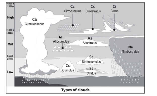
Types of Clouds
Cirrus clouds: These clouds form above 20,000 feet (6,000 meters) and since the temperatures are extremely low at such high elevations, these clouds are primarily composed of ice crystals. High-level clouds are typically thin and white in appearance, but can appear in a magnificent array of colors when the sun is low on the horizon.
Cirro-cumulus: These clouds appear as small, rounded white puffs. The small ripples in the cirro-cumulus sometimes resemble the scales of a fish. A sky with cirro-cumulus clouds is sometimes referred to as a “mackerel sky.”
Cirro-stratus: These clouds are thin, sheet-like high clouds that often cover the entire sky. They are so thin that the sun and the moon can be seen through them.
Altocumulus clouds: These are middle level clouds that are made up of water droplets and appear as gray, puffy masses, sometimes rolled out in parallel waves or bands.
Altostratus clouds: These are gray or blue- gray middle level clouds composed of ice crystals and water droplets. These clouds usually cover the entire sky. In the thinner areas of the cloud, the sun may be dimly visible as a round disk. Altostratus clouds often forms ahead of storms that produces continuous precipitation.
Stratus clouds: These are uniform grayish clouds that often cover the entire sky. They resemble fog that does not reach the ground. Usually no precipitation falls from stratus clouds, but sometimes they may drizzle. When a thick fog “lifts,” the resulting clouds are low stratus.
Nimbostratus clouds: These form a dark gray, “wet” looking cloudy layer associated with continuously falling rain or snow. They often produce precipitation that is usually light to moderate.
Cumulonimbus clouds: These are thunderstorm clouds that form if cumulus clouds continue to grow vertically. Their dark bases may be no more than 300 m (1000 ft) above the Earth’s surface. Their tops may extend upward to over 12,000 m (39,000 ft). Tremendous amount of energy is released by the condensation of water vapour within a cumulonimbus. Lightning, thunder, and even violent tornadoes are associated with the cumulonimbus.
Cumulus Clouds: These are puffy clouds that sometimes look like pieces of floating cotton. The base of each cloud is often fat and may be only 1000 m (330 ft) above the ground. The top of the cloud has rounded towers. When the top of the cumulus resembles the head of a cauliflower, it is called cumulus congestus or towering cumulus. These clouds grow upward, and they can develop into a giant cumulonimbus, which is a thunderstorm cloud.
Precipitation
- Precipitation is water released from clouds in the form of rain, freezing rain, sleet, snow, or hail on the Earth’s surface.
- When air is lifted in the atmosphere, it expands and cools and leads to the formation of clouds.
- The clouds floating overhead contain water vapor and cloud droplets, which are small drops of condensed water.
- For precipitation to happen, first tiny water droplets must condense on even tinier dust, salt, or smoke particles, which act as a nucleus.
- Some vapor freezes into tiny ice crystals which attract cooled water drops. The drops freeze to the ice crystals, forming larger crystals known as snowflakes.
- When the snowflakes become heavy, they fall as it exceeds the cloud updraft speed.
- When the snowflakes meet warmer air on the way down, they melt into raindrops.
Conditions of Occurrence of Precipitation
- Precipitation is the result of a complex series of micro-physical processes within a cloud.
- Precipitation may form as a result of collision and coalescence within a cloud.
- Precipitation may form where ice crystals and water droplets coexist within a cloud; this precipitation mechanism is known as the Bergeron-Findeisen process.
- Precipitation-size droplets do not form instantly. It takes time for the droplets to grow in size. Only if the conditions favorable to droplet growth last for a sufficient length of time then only precipitation will reach the ground.
There are three major types of Rainfall
- Conventional Rainfall: It occurs when moist air, having been warmed by Conduction from a heated surface, expands, rises and is adiabatically cooled to the dew point. Cumulus clouds develop and may fall accompanied by thunder. Convectional rainfall occurs commonly during the afternoon near the equator due to high temperature and high humidity.
- Orographic Rainfall: This type of rainfall occurs when air is forced to ascend the side of a mountain range. When land barriers such as mountain ranges, hilly regions or even escarpments of plateaus lie in the path of prevailing winds, large portion of the atmospheric air is forced to rise above these barriers. This resultant precipitation is termed as orographic. Because the air has deposited on the windward side of the mountain, there will be normally less rainfall on the leeward side which is known as RAIN SHADOW AREA.
- Frontal Rainfall: Cyclonic or Frontal precipitation results when the warm, moist air mass (warm front) meets a cool and dry air mass (cold front). The molecules in the cold air are more tightly packed together (i.e., more dense), and thus, the cold air is heavier than the warm air. The warmer air mass is forced up over the cool air. As it rises, the warm air cools, the water vapour in the air condenses, and forms clouds and results in precipitation.
Factors Affecting Rainfall Distribution
- Moisture supply to the atmosphere is the main factor in determining the amount of rainfall in any region. Equatorial and rest of the tropical region have highest evaporation and hence highest supply of moisture. Coastal areas have more moisture than interior parts of continents. Frigid regions have very low evaporation hence very scanty precipitation.
- Wind direction in the belts of trades and westerlies winds is very important. Winds blowing from sea to land cause rainfall. Land bearing winds are dry. Winds blowing from higher to lower latitudes will get heated and give no rain while those blowing from lower to higher latitudes will get cooled and cause rainfall. Sub-tropical deserts have very little rainfall because they have of -shore winds.
- Ocean currents Warm current are associated with warm moist winds which cause rainfall,cold current have cold dry wind and hence no rainfall.
- Presence of mountain across the direction of wind causes more rainfall on the windward side and creates rain shadow on the leeward side.
- Pressure belts are closely related with wind direction and rainfall. Areas of low pressure attract rain bearing winds while areas of high pressure do not.
Kerala on alert as MAHA intensifies into super cyclone off its coast
Context
- The Kerala State Disaster Management Authority (KSDMA) set up 11 shelter camps in the state as cyclonic storm Maha in the Arabian Sea intensified into a severe cyclonic storm.
- It urged fishermen not to venture into the sea, putting several districts on yellow alerts.
About
- Storm not likely to hit state directly. However, there would be heavy wind and rain.
- The India Meteorological Department (IMD) stated that the storm was over Lakshadweep and adjoining southeast Arabian Sea, moving north-north westwards.
- It intensified into a severe cyclonic storm and lay cantered over east-central Arabian Sea and adjoining Lakshadweep area, about 325 kilometre west-northwest of Kozhikode.
- With the cyclone intensified, the IMD forecast wind at 100-110 kilometre per hour, gusting 120 kmph over east-central Arabian Sea.
- Lakshadweep is likely to receive extremely heavy rainfall and the IMD issued a “red message” for the island.
Cyclone Maha
- Cyclone Maha, the fourth cyclone of 2019 in the Arabian Sea, was set to intensify further into a 'Severe Cyclonic Storm'
- The depression that had developed in the Comorin Sea, gained strength and turned into a cyclonic storm.
- An Orange alert had been issued in four districts of Kerala —Ernakulam, Thrissur, Malappuram and Kozhikode.
STORMQUAKE
Context:
- Scientists have discovered an earthquake-like event “stormquake” that can happen during a hurricane or other powerful ocean storms.
What is a stormquake?
- It is a new geophysical phenomenon entirely unknown to science - a hybrid entity where powerful storms such as hurricanes trigger seismic episodes that can rumble for hours or even days.
- Storms trigger giant waves in the sea, which cause another type of wave. These secondary waves then interact with the seafloor only in certain places and that causes the shaking.
- Stormquakes are limited to places along the edge of continental shelves or on ocean banks.
- Stormquakes frequently occur in the Maritimes and Labrador Sea in the North American margin.
When is a stormquake generated?
- To be a stormquake the source of the seismic data had to meet several criteria:
- It had to occur during a stormy day.
- It should not to be a part of known earthquake event and belong to a swarm of similar quakes on the same day.
- Stormquakes are confined to certain regions along the coast where seafloor topography has small raised regions called ocean banks.
Examples of stormquake:
- Hurricane Bill, a storm that formed 10 years ago in the Atlantic Ocean. Bill strengthened into a Category 4 hurricane before weakening to a tropical storm and hitting Newfoundland. This storm caused "numerous seismic events “off the northeast U.S. and Canadian coasts. As Bill approached several stormquakes located offshore New England and Nova Scotia were detected and caused continent-wide ground motions that lasted for about 30 hours.
- Hurricane Ike (2008) and Hurricane Irene (2011) which led to stormquake activity in the Gulf of Mexico, while Irene caused seismic events off the coast of southern Florida.
Golden Triangle and Golden Crescent
About
- Golden Triangle and Golden Crescent are the Asia’s two largest principal illicit opium producing areas.
The Golden Crescent
- The Golden Crescent is located in Southwest Asia and consists of three contiguous countries of Pakistan, Afghanistan and Iran from East to West.
- Iran is the largest country, Afghanistan the only land locked country and Pakistan shares the maximum land boundaries in this region.
- This is the world's leading illicit opium producing region with the potential production of 5,020 metric tons, out of which Afghanistan alone has 4,950 metric tons of illicit opium production, followed by Pakistan with meager 70 metric tons in 2005 (UNODC, INCSR, 2006).
- Iran is not an opium producing country in this region but is more that of a trans-shipment country.
The Golden Triangle
- The Golden Triangle is located in Southeast Asia comprising of three contiguous countries of Laos, Thailand and Myanmar from East to West.
- Myanmar is the largest country; Laos is the only landlocked country not only of the Golden Triangle but also of that of the entire Southeast Asia and Thailand has the largest coastline in the region.
- The Golden Triangle is the world's second largest illicit opium producing region with a potential production of 5,020 metric tons out of which, Myanmar itself has 30,900 metric tons followed by 10,000 metric tons in Laos and Thailand having the least production of 128 metric tons in 2005 (UNODC, INCSR, 2006). Laos is more that of trans-shipment country. Thailand and Myanmar are money laundering countries.
Comparative Geospatial Profile
- Golden Crescent is territorially larger than Golden Triangle.
- Both Golden Crescent and Golden Triangle are similar regarding the major coastal features such as seas, gulf and deltas. The coastally neighboring countries to Golden Triangle and Golden Crescent make trans-boundary narco-trafficking an international concern.
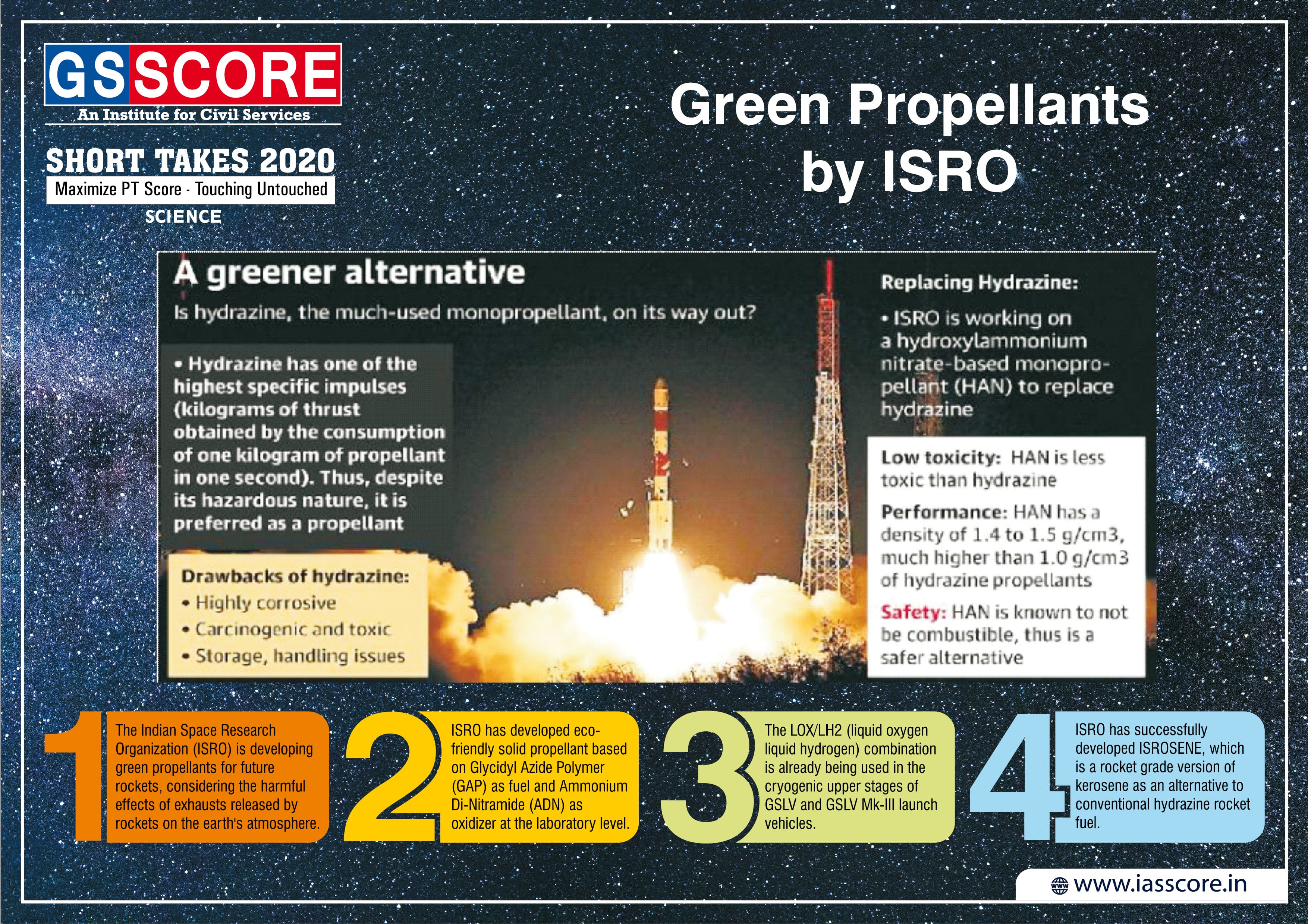
Green Propellants by ISRO
Two Stage to Orbit (TSTO) Space Transportation System
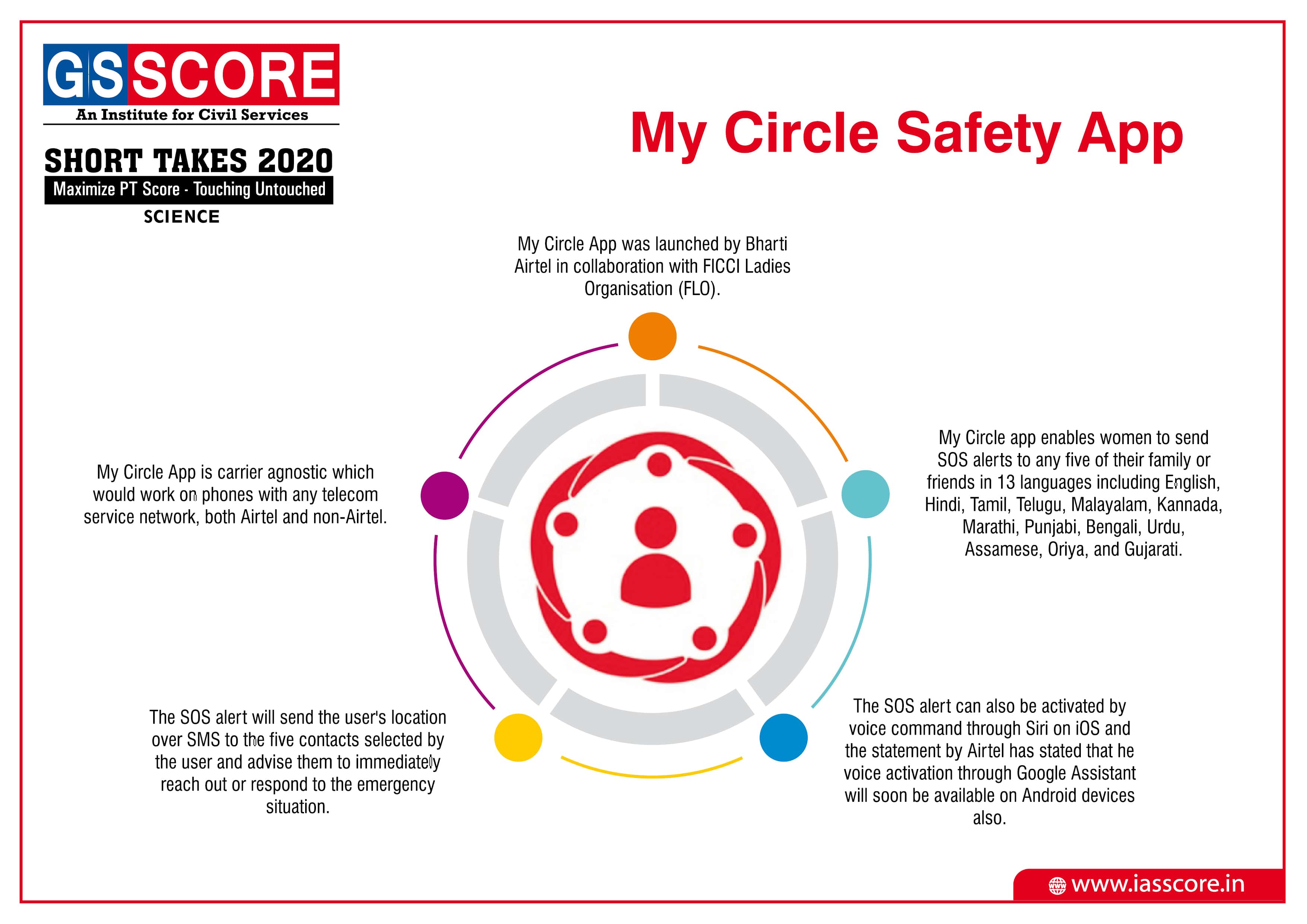
My Circle Safety App
Homo Luzonensis

NASA Developing First Asteroid Deflection Mission