Geography: Concepts of Geomorphology
Concepts of Geomorphology
Evolution of Oceans and Continents
The Theory of Continental
German meteorologist Alfred Wegener observed similarities among the continents that suggested the landmasses might have once been connected.
Coastal fit: The “jig-saw” fit of opposing coasts of continents across Atlantic Ocean. The eastern coast of South America fits into western coast of Africa. Similar case is with eastern coast of North America fitting into western coast of Europe.
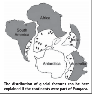
Fossil evidences: There is a similarity in the fossils found in distant lands across oceans and sometimes at places where it should not be. Glaciation evidences found in landmasses such as Brazil, South Africa and peninsular India indicates that once these landmasses were in polar or subpolar region which is consistent with Wegner’s hypothesis of Pangea located somewhere near South pole.
Geological evidences: The rocks and minerals found in distant lands were found to be having similarity in their structure and age. The coal deposits found in Alps region were similar to those found in North America.
Later, other evidences also came out which supported Wegner’s Continental Drift Theory. Those evidences are:
Paleomagnetism: These form the most reliable proof of the continental drift. The rocks found at any place preserve the magnetic properties like magnetic declination, inclination and polarity of that place during their time of cooling and rock formation. The socks of similar paleomagnatic evidence found at different location.
These observations led Alfred Wegner to formulate his “Theory of Continental Drift”, through which he tried to explain these anomalies.
Hypothesis
- All the continents were once combined as a single landmass called Pangea, which means “all lands” in Greek, during Carboniferous period.
- Pangea was surrounded by a vast water body which he called Panthalassa.
- Pangaea broke into two landmasses namely northern part which became Lauratia and the southern part namely Gondwanaland. A water body developed between these two landmasses known as Tethys Sea. The two landmasses drifted northward and westward.
- The northward movement was due to the gravitational attraction force exerted by the earth’s equatorial bulge. Wegner called this “pole fleeing”. The westward movement of landmasses was attributed to the tidal force exerted by moon and the sun.
- During the drifting of both the landmasses, they again broke due to differential dragging force into different continents.
Criticism of Wegner’s Continental Drift Theory
- The driving force that Wegner suggested for the drift of landmasses was questioned. It has been argued that the tidal force of Moon and Sun cannot be of the magnitude to move such huge landmasses. If it were of so large magnitude then the rotation of earth would have been stopped due to effect of these forces.
- The assumption of Wegner that Sial floated over Sima and the formation of fold mountains which according to him were due to scrapping of of Sima and their folding was contradicted on the basis that it was not possible for a lighter Sial to scrap Sima and if any scrapping had been there, it would be of Sial not Sima.
- Another assumption of Wegner based on Suess theory that ocean floors are exposed part of Sima ( or mantle) does not hold ground now, as it is now evidently proved that they are part of crust only, not the exposed part of mantle.
- The fossil evidence given by Wegner was countered by another “Theory of Parallel evolution”, according to which it was possible for particular specie to evolve at two different places at the same period of time.
Sea - Floor Spreading
- According to Harry Hess, the hot magma rises from mantle to the surface by convection currents at the site of Mid Oceanic Ridges (MOR) and then diverges along two limbs on either side of MOR. This diverging limb drags the crust lying above it, causing them to diverge too. The diverging limb descends inside the crust at the boundary of continental crust dragging again the oceanic crust causing ocean crust to melt and destroyed at the site of trenches.
- Since a new crust is formed at the site of MORs, it is considered as constructive zone while at trenches, the oceanic crust is destroyed and hence the site is a destructive zone. This means that oceanic crust is continuously being destroyed and new crust being formed. This explains why rocks of continental crust are much older than those found at oceanic crust although oceanic crust was the basis of all. In other way, “Oceanic crust is destructible while continents are forever”.
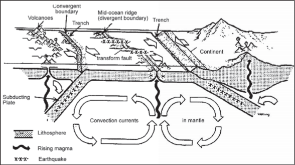
Plate Tectonics Theory
By combining the sea floor spreading theory with continental drift and information on global seismicity, the new theory of Plate Tectonics became a coherent theory to explain crustal movements. According to the theory, plates are composed of lithosphere, about 100 km thick that “float” on the ductile asthenosphere. As of now there are six major plates and six minor plate’s identified.
Major Plates
- Indian plate or Indo-Australian plate
- Pacific plate
- American plate (divided into North American plate and South American plate)
- African plate
- Eurasian plate
- Antarctica plate
While the continents do indeed appear to drift, they do so only because they are part of larger plates that float and move horizontally on the upper mantle asthenosphere. The plates behave as rigid bodies with some ability to flex, but deformation occurs mainly along the boundaries between plates. The plate boundaries can be identified because they are zones along which earthquakes occur. Plate interiors have much fewer earthquakes.
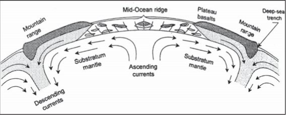
Plate Boundaries
There are three types of plate boundaries:
Divergent Plate boundaries:
- These are areas where plates move away from each other, forming either mid-oceanic ridges or rift valleys. These are also known as constructive boundaries.
- Regions of Divergent Boundaries
- East African Rift (Great Rift Valley) in eastern Africa
- Mid-Atlantic Ridge system separates the North American Plate and South American Plate in the west from the Eurasian Plate and African Plate in the east
- Gakkel Ridge is a slow spreading ridge located in the Arctic Ocean
- East Pacific Rise, extending from the South Pacific to the Gulf of California
- Baikal Rift Zone in eastern Russia
- Red Sea Rift
- Aden Ridge along the southern shore of the Arabian Peninsula
- Carlsberg Ridge in the eastern Indian Ocean
- Gorda Ridge of the northwest coast of North America
- Explorer Ridge of the northwest coast of North America
- Juan de Fuca Ridge of the northwest coast of North America
- Chile Rise of the southeast Pacific
Convergent Plate Boundaries:
- Convergent boundaries are areas where plates move toward each other and collide. These are also known as compressional or destructive boundaries.
- Subduction zones occur where an oceanic plate meets a continental plate and is pushed underneath it. Subduction zones are marked by oceanic trenches. The descending end of the oceanic plate melts and creates pressure in the mantle, causing volcanoes to form.
- Obduction occurs when the continental plate is pushed under the oceanic plate, but this is unusual as the relative densities of the tectonic plate’s favours subduction of the oceanic plate. This causes the oceanic plate to buckle and usually results in a new mid ocean ridge forming and turning the obduction into subduction.
- Orogenic belts occur where two continental plates collide and push upwards to form large mountain ranges. These are also known as collision boundaries
- Regions of Convergent Boundaries-Few of the regions are mentioned below:
- The oceanic Nazca Plate subducts beneath the continental South American Plate at the Peru–Chile Trench.
- Just north of the Nazca Plate, the oceanic Cocos Plate subducts under the Caribbean Plate and forms the Middle America Trench.
- Cascadia subduction zone is where the oceanic Juan de Fuca, Gorda and Explorer Plates subduct under the continental North American plate.
- Oceanic Pacific Plate subducts under the North American Plate (composed of both continental and oceanic sections) forming the Aleutian Trench.
Transform Plate Boundaries
Occur when two plates grind past each other with only limited convergent or divergent activity.
- Regions of Transform Boundaries
- The San Andreas Fault in California is an active transform boundary. The Pacific Plate (carrying the city of Los Angeles) is moving northwards with respect to the North American Plate.
- The Queen Charlotte Fault on the Pacific Northwest coast of North America.
- The Motagua Fault, which crosses through Guatemala, is a transform boundary between the southern edge of the North American Plate and the northern edge of the Caribbean Plate.
- New Zealand’s Alpine Fault is another active transform boundary.
- The Dead Sea Transform (DST) fault which runs through the Jordan River Valley in the Middle East.
- The Owen Fracture Zone along the southeastern boundary of the Arabian Plate
Mountains:
- A portion of land rising considerably above the surrounding country either as a single eminence (Kilimanjaro) or in range (Himalayas, Rockies, Andes), is known as ‘mountain’.
- Orogeny (Orogenesis): A period of mountain building involving the process of intense upward displacement of the earth’s crust, usually associated with folding, thrust faulting and other compressional processes.
Fold Mountains
- Fold Mountains are formed at convergent boundaries at the meeting point of two tectonic plates.
- Fold Mountains are formed as a result of the compression of tectonic plates, which leads to the formation of large fold-like structures on the earth’s crust.
- Fold Mountains primarily exist as mountain ranges, and the majority of the earth’s well-known mountain ranges are examples of Fold Mountains.
Characteristics of Fold Mountains
- Fold Mountains belong to the group of youngest mountains of the earth.
- The presence of fossils suggests that the sedimentary rocks of these folded mountains were formed after accumulation and consolidation of silts and sediments in a marine environment.
- Fold Mountains extend for great lengths whereas their width is considerably small.
- Generally, Fold Mountains have a concave slope on one side and a convex slope on the other.
- Fold Mountains are found along continental margins facing oceans.
- Fold Mountains are characterized by granite intrusions on a massive scale.
- Recurrent seismicity is a common feature in folded mountain belts.
- High heat flow often finds expression in volcanic activity.
- These mountains are by far the most widespread and also the most important.
- They also contain rich mineral resources such as tin, copper, gold.
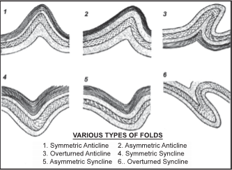
Types of Folds
According to the shape, the folds are of many types:
Symmetrical Folds: These are ordinary folds. The limbs of the folds are equally inclined on either side.
Asymmetrical Fold: One of the limbs is more inclined than the other.
Monoclinal Fold: In this fold, one limb makes a right angle with the surface but the other limb is ordinarily inclined.
Isoclinal Fold: The two limbs are so much inclined in such a way that they appear equally inclined and parallel to each other.
Recumbent Fold: In this fold the two limbs are so much inclined that they become horizontal.
Overturned Fold: In this fold one limb is overturned over the other limb. The difference between the overturned and recumbent folds is that the overturned limbs are not horizontal like those of recumbent fold.
Plunging Fold: If the axis of the fold is not parallel to the horizontal but makes an angle with it, it is known as Plunging Fold.
Fan Fold: It is a great anticline which has many small anticlines and synclines. It is also known as Anticlinorium. A great syncline having many small anticlines and synclines is called Synclinorium.
Open Fold: If the angle between the limbs of a fold is obtuse, the fold is called Open Fold.
Closed Fold: If the angle between the limbs of a fold is acute, it is called Closed Fold.
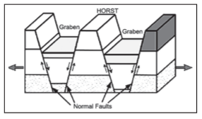
Block Mountains
- Block Mountains are formed when two tectonic plates move away from each other causing cracks on the surface of the Earth. When parallel cracks or faults occur, the strip of land or the block of land between them may be raised resulting in the formation of Block Mountains. The upward block is called a horst. Examples, Black forest and the Vosges of Rhineland.
- Block Mountains are also formed when the crust of the Earth sinks on both sides of two parallel faults. Therefore, a block mountain can be found between two rift valleys. The land which sinks is known as graben. Examples, East African rift valleys.
Residual Mountains
- These are mountains evolved by denudation.
- Where the general level of the land has been lowered by the agents of denudation some very resistant areas may remain and these form residual mountains, e.g. Mt. Manodnock in U.S.A.
- Residual Mountains may also evolve from plateaus which have been dissected by rivers into hills and valleys. Examples of dissected plateaux, where the down-cutting streams have eroded the uplands into mountains of denudation, are the Highlands of Scotland, Scandinavia and the Deccan Plateau.
Volcanism
- A volcano is an opening in the earth’s crust through which gases, molten rocks materials (lava), ash, steam etc. are emitted outward in the course of an eruption.
- Such vents or openings occur in those parts of the earth’s crust where the rock strata are relatively weak.
- Volcanic activity is an example of endogenic process. Depending upon the explosive nature of the volcano, different land forms can be formed such as a plateau (if the volcano is not explosive) or a mountain (if the volcano is explosive in nature).
Types of Lava
- Basic lavas: There are highly fluid. They are dark coloured like basalt, rich in iron and magnesium but poor in silica. They are affect extensive areas, spreading out as thin sheets. The resultant volcano is gently sloping with a wide diameter and form a fattened shield or dome.
- Acidic lavas: There lavas are highly viscous with a melting point. They are light-coloured, of low density, and have a high percentage of silica. They flow slowly and seldom travel far. The resultant cone is therefore steep sided.
Types of Volcanoes
- Classification of Volcanoes according to shape
Cinder cones-are circular or oval cones made up of small fragments of lava from a single vent that has been blown up.
- Cinder cones result from eruptions of mostly small pieces of scoria and pyroclastic that builds up around the vent. Most cinder cones erupt only once.
- Cinder cones may form as flank vents on larger volcanoes, or occur on their own.
Composite Volcanoes: These are steep-sided volcanoes composed of many layers of volcanic rocks, usually made from high-viscosity lava, ash and rock debris.
- These types of volcanoes are tall conical mountains composed of lava flows and other ejected in alternate layers, the strata that give rise to the name.
- Composite volcanoes are made of cinders, ash, and lava. Cinders and ash pile on top of each other, lava flows on top of the ash, where it cools and hardens, and then the process repeats.
Shield volcanoes are volcanoes shaped like a bowl or shield in the middle with long gentle slopes made by basaltic lava flows.
- These are formed by the eruption of low-viscosity lava that can flow a great distance from a vent.
- They generally do not explode catastrophically.
- Since low-viscosity magma is typically low in silica, shield volcanoes are more common in oceanic than continental settings.
- The Hawaiian volcanic chain is a series of shield cones, and they are common in Iceland, as well.
Lava domes are formed when erupting lava is too thick to flow and makes a steep-sided mound as the lava piles up near the volcanic vent.
- They are built by slow eruptions of highly viscous lava.
- They are sometimes formed within the crater of a previous volcanic eruption.
- Like composite volcano, they can produce violent, explosive eruptions, but their lava generally does not flow far from the originating vent.
- According to flow of magma and its place of cooling, volcanism may be categorized into:
- Extrusive volcanism: Magma is expelled onto surface.
- Intrusive Volcanism: Magma solidifies in the shallow crust near the surface. It can be exposed after weathering.
- Plutonic Volcanism: Magma solidifies deep inside the earth’s crust
- Classification of Volcanoes on the basis of Periodicity:
- Active Volcanoes: When volcanic materials like lava, gases, ash, cinder, pumice etc. are ejected constantly from the vent. Most of the active volcanoes are found in the Circum-Pacific Belt which is known as the ‘Ring of Fire’. A few examples of active volcanoes are: Etna and Visuvius, Mount Pelee (Martinique), Mount Karmai (Alaska), Mount Saint Helens, Nevado Del Ru’z (Columbia), Mount Unzen (Japan), Mount Pinatubo (Philippines), Mount Redoubt (Alaska) and Mount Mayon (Philippines). The Stromboli volcano emits so much fire and incandescent gases that it is known as ‘the Light House of the Mediterranean Sea’.
- Dormant Volcanoes: Those that have been known to erupt and show signs of possible eruption in the future. These are not extinct. For example: The Vesuvius erupted in 79 AD, 1631, 1803, 1872, 1906, 1927, 1928 and 1929. Violent eruptions of dormant volcanoes are generally preceded and accompanied by earthquakes, some of which have been very destructive. Example Mt. Kilimanjaro.
- Extinct Volcanoes: A volcano that was active in the geological past and no longer has any active vulcanicity. The Crater is filled with water. For example: St. Arthur’s Sea (Edinburgh) and the numerous Crater Lakes in the Andes and Rockies Mountains. Some of the volcanoes that are today dormant may become active. For example: Monte Somma which erupted 700 years back are now considered extinct by the inhabitants.
World distribution of Volcanoes
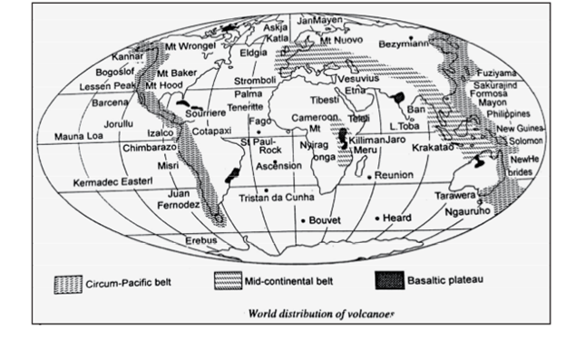
The Circum Pacific Belt:
- Due to subduction of the Pacific plate below the Asiatic plate, the large number of volcanic eruptions are found circling Pacific Ocean known as Ring of Fire, which extends through the Andes of South America, Central America, Mexico, the Cascade Mountains of Western United States, the Aleutian Islands, Kamchatka, the Kuril Isles, Japan, the Philippines, Celebes, New Guinea, the Solomon Islands, New Caledonia and New Zealand where about 80 active volcanoes are found.
- The Circum-Pacific belt meets the mid- continental belt in the East Indies. This belt is characterised by high volcanic cones and volcanic mountains.
- The volcanoes of the Aleutian Island, Hawaii Island and Japan are found in Chains.
- Cotapaxi is the highest volcanic mountain (6035m) in the world.
- Other important volcanoes found in this belt are Fuziyama, Shasta, Rainer and Hood.
- Volcanic eruptions occur in this belt because of the subduction of the Pacific plate below the Asiatic plate.
The Mid-Continental Belt:
- Having various volcanoes of the Alpine Mountain Chain, Mediterranean Sea (Stromboli, Vesuvius, Etna etc.), volcanoes of the Aegean Sea, Mt. Ararat, Elburz and Hindukush. There are several volcanic free zones found along the Alps and the Himalayas, come under this belt. Kilimanjaro, Elgon, Birunga and Rungwe etc. are the volcanoes found in the Rift Valleys of Africa.
- In the region where the boundaries of Persia, Afghanistan, and Baluchistan meet, there are several volcanic cones of large size, and one or two of them emit steam and other gases. This region has also a few extinct volcanoes.
The Mid Atlantic Belt:
- It includes the volcanoes of the Mid-Atlantic Ridge which are associated with the Atlantic Ocean and are located either on swells or ridges rising from the sea floor or on or near the edge of the continent where it slopes abruptly into the deep oceanic basins.
- The volcanoes formed along the Mid-Atlantic Ridge actually represent the splitting zone of the American plate moving towards west and the Eurasian plate moving towards east representing the zones of crystal movement.
- In the splitting zone there is constant upwelling of Magma hence known as crustal weakness.
- Volcanoes in this belt are generally of fissure-eruption type such as Volcanoes of Lesser Antilles, Azores, and St. Helens etc.
Earthquakes
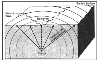
- An earthquake is the shaking or trembling of the earth’s surface, caused by the sudden movement of a part of the earth’s crust.
- They result from the sudden release of energy in the Earth’s crust that creates seismic waves or earthquake waves.
Causes of Earthquakes
- Volcanic Eruptions: Volcanic eruptions are the main cause of earthquake caused by gas explosions or the upcoming and fissuring of volcanic structures. For example: Karakota (1883), Cotopaxi, Chimborazo, Kilimanjaro, Fujiyama etc.
- Faulting (Displacement of Rocks): Earthquakes occur when movement of earth takes place along a line of fracture (FAULT). Examples: San Andres Fault of California (Los Angeles) and earthquakes of 1994 at Northridge, California.
- Plate Tectonics: The 6 major and 9 minor plates of the earth crust are constantly moving at different rates. The boundaries of these plates are the primary location of earthquakes, example: the Ring of Fire. Shallow focus earthquakes occur on the Oceanic Ridges and in the Oceanic Trenches, deep focus earthquakes occur.
- Anthropogenic Factors (Human’s over Integration with Nature): Extraction of minerals and the dams built on time to time disturbing the earth’s balance – Marathon Dam (Greece) – 1929, Koyna (Maharashtra 1962), Hoover Dam (1935), Mangla Dam (Pakistan), Kariba Dam (Zambia), Manic Dam (Canada), Kurobe Dam (Japan).
Seismic Waves or Earthquake Waves
The seismic waves can be classified into two categories:
- Surface Waves: These waves travel through the surface of the earth. Due to their amplitude, they are most destructive waves causing extensive damage on the surface of earth.
Types of Surface Wave
- Love waves (L-waves): It is fastest surface waves and move on ground side to side. It is confined to surface of the crust love wave is wounded by Seismograph.
- Rayleigh waves: Rayleigh waves rolls along the ground just like a wave roll across a lake or an ocean.
- Stoneley waves: Stone waves propagate along a solid - fluid boundary and also along solid - solid boundary.
- Standing waves: Standing waves are the result of free oscillation of earth. When two waves moving opposite to each other interfere standing waves are produced.
- Body waves: These waves travel through the interiors of the earth. While travelling through interiors, their characteristics such as velocity and wavelength changes according to the density of the medium in which they are travelling. Body Waves can be further categorized into:
- Primary Waves: Also known as P-waves. These are longitudinal or compressive in nature. These waves can pass through solid as well as liquid medium. The velocity of these waves increases with increasing density and rigidity of the medium. (They travel faster in solid than in liquids)
- Secondary waves: Also known as S-waves. These are transverse or distortional in nature. These waves cannot pass through liquid medium. Their velocity also increases with increasing rigidity of the medium.
Measuring Earthquakes
- Seismometers are the instruments which are used to measure the motion of the ground, which including those of seismic waves generated by earthquakes, volcanic eruptions, and other seismic sources.
- A Seismograph is also another term used to mean seismometer though it is more applicable to the older instruments.
- The recorded graphical output from a seismometer/seismograph is called as a seismogram. (Note: Do not confuse seismograph with seismogram. Seismograph is an instrument while seismogram is the recorded output)
- There are two main scales used in the seismometers:
- Mercalli Scale: The scale represents the intensity of earthquake by analyzing the after effects like how many people felt it, how much destruction occurred etc. The range of intensity is from 1-12.
- Richter Scale: The scale represents the magnitude of the earthquake. The magnitude is expressed in absolute numbers from 1-10. Each whole number increase in Richter scale represents a ten times increase in power of an earthquake.
Earthquake Zones in the World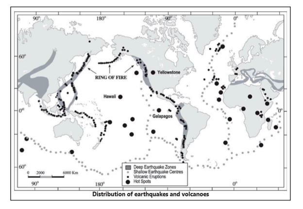
Circum-Pacific Zone: This zone is mainly distributed along the subsidence zone along trenches, where oceanic plate subducts under continental plate. Enormous amount of energy is released in earthquakes which occur in this zone. The depth of focus may vary greatly in accordance with Benioff zones which can result in focus as deep as 300 to 700 km below sea level.
The Mediterranean and Trans-Asiatic zone: This zone runs along the fold mountain chains from Alpine system of Europe through Asia, Iran and Himalayan mountain system. These earthquakes owe their origin to collision of continental plates and resulting buckling of plates. These earthquakes have generally shallow to intermediate focus.
The Mid-Oceanic Ridges and the African Rift System: This runs along the mid-oceanic ridges through the oceans. These have generally shallow focus.
Earthquake Zones in India
Bureau of Indian Standards based on the past seismic history, grouped the country into four seismic zones, viz. Zone-II, -III, -IV and –V. Of these, Zone V is the most seismically active region, while zone II is the least. The Modified Mercalli (MM) intensity, which measures the impact of the earthquakes on the surface of the earth, broadly associated with various zones, is as follows: Seismic Zone Intensity on MM scale:
- Zone-V comprises of entire northeastern India, parts of Jammu and Kashmir, Himachal Pradesh, Uttaranchal, Rann of Kutch in Gujarat, parts of North Bihar and Andaman & Nicobar Islands.
- Zone-IV covers remaining parts of Jammu & Kashmir and Himachal Pradesh, Union Territory of Delhi, Sikkim, northern parts of Uttar Pradesh, Bihar and West Bengal, parts of Gujarat and small portions of Maharashtra near the west coast and Rajasthan.
- Zone-III comprises of Kerala, Goa, Lakshadweep islands, and remaining parts of Uttar Pradesh, Gujarat and West Bengal, parts of Punjab, Rajasthan, Madhya Pradesh, Bihar, Jharkhand, Chhattisgarh, Maharashtra, Odisha, Andhra Pradesh, Tamil Nadu and Karnataka.
- Zone-II covers remaining parts of the country. Further, as part of pre-disaster preparedness measure, Government of India has also completed seismic micro-zonation studies of some of the major cities in the country such as, Jabalpur, Guwahati, Bengaluru, greater Bharuch in Gujarat, Jammu in J&K, Shillong in Meghalaya, Chennai in Tamil Nadu and Sikkim state.
Drake Passage and “The Impossible Row” Project
Context
In a first, six rowers from four countries crossed the Drake Passage, in just under two weeks after pushing off from the southern tip of South America.
About
- The Passage is located between Cape Horn at the tip of South America and the Antarctic Peninsula.
- This is the first completely human-powered crossing of the passage.
- The project was dubbed “The Impossible Row”, for which the team departed from Cape Horn in Chile and arrived at Primavera Base on San Martin Land on the Antarctic Peninsula.
What is the Drake Passage?
- The passage is named after Sir Francis Drake, who was the first Englishman to circumnavigate the globe.
- The passage has an average depth of about 11,000 feet, with deeper regions going up to over 15,600 feet near the northern and southern boundaries.
Why is it considered so treacherous?
- The Drake Passage is considered one of the roughest waterways in the world because here, layers of cold seawater from the south and warm seawater from the north collide to form powerful eddies, which when combined with strong winds and storms can be treacherous for those attempting to navigate it.
- It is also the narrowest stretch in the Southern Ocean and spans approximately 800 km between the southern tip of South America and the northern tip of the West Antarctic Peninsula.
- NASA describes the waters of the passage as “notoriously turbulent, unpredictable, and frequented by icebergs and sea ice.
What is Annular Solar Eclipse
Context
The last solar eclipse of this year took place in December, which will fall over the eastern hemisphere of the Earth and be visible from India, Saudi Arabia, Qatar, Malaysia, Oman, Singapore, Sri Lanka, Mariana Islands and Borneo among a few other places.
About
- An eclipse happens when the moon while orbiting the Earth, comes in between the sun and the Earth, due to which the moon blocks the sun’s light from reaching the Earth, causing an eclipse of the sun or a solar eclipse.
- It was visible from India, Saudi Arabia, Qatar, Malaysia, Oman, Singapore, Sri Lanka, Mariana Islands and Borneo among a few other places.
About annular solar eclipse
- There are three types of eclipses: one is a total solar eclipse, which is visible only from a small area on Earth.
- People who are able to view the total solar eclipse are in the centre of the moon’s shadow as and when it hits the Earth.
- A total solar eclipse happens when the sun, moon and Earth are in a direct line.
- The second type of a solar eclipse is a partial solar, in which the shadow of the moon appears on a small part of the sun.
- The third kind is an annular solar eclipse, which happens when the moon is farthest from the Earth, which is why it seems smaller.
- In this type of an eclipse, the moon does not block the sun completely, but looks like a “dark disk on top of a larger sun-colored disk” forming a “ring of fire”.
Additional information
- Furthermore, during a solar eclipse the moon casts two shadows on the Earth, the first one is called the umbra, which gets smaller as it reaches the Earth.
- The second one is called the penumbra, which gets larger as it reaches the Earth.
- According to NASA, people standing in the umbra see a total eclipse and those standing in the penumbra see a partial eclipse.
- One of the reasons that NASA studies solar eclipses is to study the top layer of the sun called the corona.
- During an annular eclipse, NASA uses ground and space instruments to view this top layer when the sun’s glare is blocked by the moon.
Where can the annular solar eclipse be viewed from In India?
- Some of the areas in India from where the annular solar eclipse can be viewed include Kannur, Ooty, Palakkad, Kozhikode, Erode Trichy, Madurai and Karaikudi among a few others.
Is it safe to view solar eclipses?
- NASA maintains that the sun can be viewed safely using the naked eye only during a total eclipse, while during partial and annular solar eclipses, the sun should not be viewed without proper equipment and techniques.
- Not using proper methods and equipment for viewing can cause permanent eye damage or severe visual loss.
- Safety equipment includes eclipse glasses and using appropriate solar filters for covering binoculars, telescopes and cameras.
Rohtang Tunnel
Context
Prime Minister honoured the contribution of former Prime Minister Atal Bihari Vajpayee by naming the Strategic Tunnel under Rohtang Pass after him.
About
- The historic decision to construct a strategic tunnel below the Rohtang Pass was taken on June 03, 2000, when late Atal Bihari Vajpayee was the Prime Minister.
- The foundation stone for the Access Road to the South Portal of the tunnel was laid on May 26, 2002.
How long is the tunnel, and what is special about it?
- Upon completion, the 8.8 km-long tunnel will be the world’s longest highway tunnel at an altitude of above 10,000 feet (3,000 metres).
- It is a 10.5 m-wide single tube, a bi-lane tunnel with a fireproof emergency tunnel built into the main tunnel itself. The 10.5-m width includes a 1-metre footpath on both sides.
- Vehicles will travel at a maximum speed of 80 km per hour inside the tunnel. Up to 3,000 cars and 1,500 trucks are expected to use the tunnel every day.
- It will reduce the distance between Manali and Leh by 46 kilometres and save crores of rupees in transport costs.
- It will also provide all-weather connectivity to remote border areas of Himachal Pradesh and Ladakh, which otherwise remained cut off from the rest of the country for about six months.
- The project has significant strategic implications for the military. Once the tunnel is operational, the forces will have access beyond the Rohtang Pass even in peak winter.
- The tunnel is now nearing completion and is a step in the direction of providing all weather connectivity to remote border areas of Himachal Pradesh and Ladakh which otherwise remained cut off from the rest of the country for about six months during winters.
- While Rohtang Pass is at a height of 13,050 feet, the pass on the road to Leh is Baralacha La at 16,040 feet. A 13.2-km long tunnel would be required to bypass this pass.
- An alternative road link to Ladakh has also been developed by BRO on the Darcha-Padam-Nimu axis, but here again; a 4.15 km-long tunnel at Sinka La Pass (16,703 feet) would be required for all-weather access.
First Global Ecosystem Assessment

Wealth Accounting and the Valuation of Ecosystem Services (WAVES)
-min.jpg)
State of Global Air-2019 Report

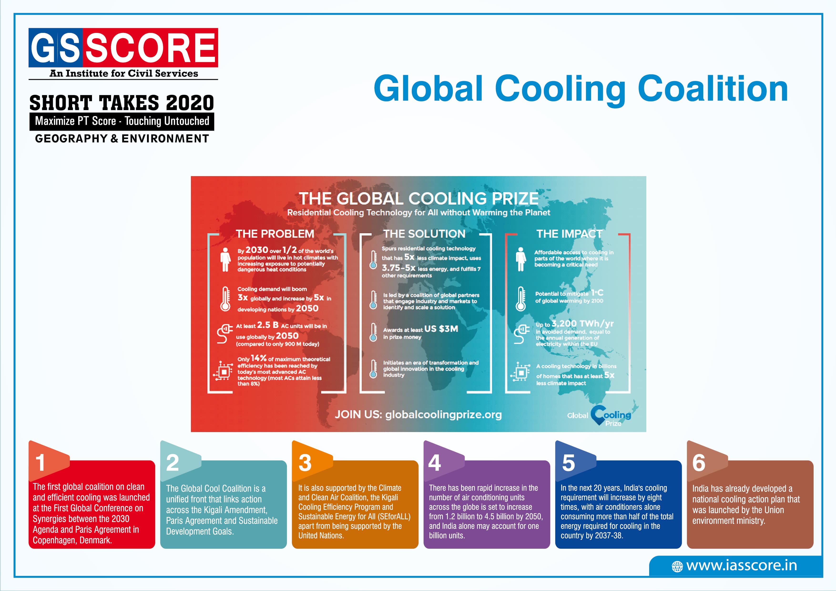
Global Cooling Coalition
Sustainable Energy for All (SEFORALL)
-min.jpg)