Geography: Human and Economic Geography Part I
Agriculture
- According to Food and Agriculture organisation (FAO), at present some 11 percent (1.5 billion ha) of the globe’s land surface (13.4 billion ha) is used in crop production (arable land and land under permanent crops).
- This area represents slightly over a third (36 percent) of the land estimated to be to some degree suitable for crop production.
- The fact that there remain some 2.7 billion ha with crop production potential suggests that there is still scope for further expansion of agricultural land.
- 40% of today’s global population works in agriculture sector making it the single largest employer in the world. Nearly 80% of world cultivated area is rainfed.
Classification
- The framework of the agricultural systems of the world, except collective farming as outlined by Whittlesey can be presented as under —
Ecological or Near-Ecological Systems
- Nomadic herding
- Shifting cultivation/Simple Subsistence Farming
Subsistence Systems
- Rudimentary Sedentary Tillage
- Intensive Subsistence Tillage (with paddy dominance)
- Intensive Subsistence Tillage (without paddy dominance)
- Subsistence Crop and Livestock Farming
- Mediterranean Agriculture (near subsistence in the occidental world)
Commercial Systems
- Mediterranean Agriculture (commercial)
- Livestock Ranching
- Commercial Grain Farming
- Commercial Livestock and Crop Farming
- Commercial Dairy Farming
- Specialised Horticulture and Olericulture (fruit & vegetable culture)
Cash-Cropping System
- Commercial Plantation Tillage
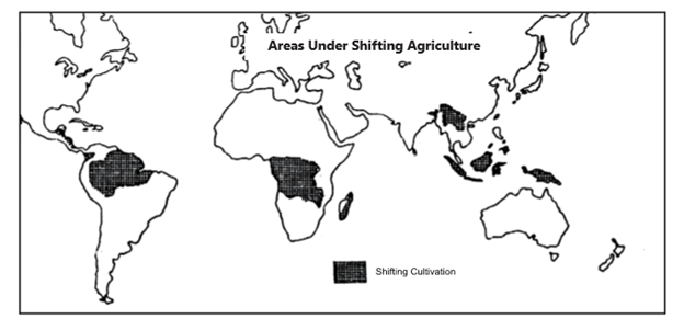
Shifting cultivation/Simple Subsistence Farming
- It is the oldest form of ‘agriculture’ having its origin in 7000/8000 B.C.
- Shifting cultivation is the primitive form of soil utilisation, usually of tropical rainforests and bush areas of Central Africa, Central America and Southeast Asia. Farming is on a self-sufficient basis and farmers grow food only for themselves and their families. Shifting cultivation has two particularly important characteristics— First , farmers usually clear the land for planting in part by slashing the vegetation and burning the debris. Second, farmers grow crops on a cleared field for only a few years and then leave it fallow for many years.
- It has significant negative environment impacts which include: deforestation inadequate land management practices soil erosion, flooding and siltation in lower reaches.
- Shifting cultivation can support only a low level of population.
- Shifting cultivation is carried on chiefly in regions with a tropical forest climate. It is widely spread in and along its borders. The tropical regions of Americas, Central Africa, and Southeast Asia (including Indonesia) may be identified as the home of shifting cultivation.
- In these regions, agriculture is known as migratory, primitive, cut-and-burn, slash-and-burn and bush fallow agriculture.
Rudimentary Sedentary Tillage
- This form of agriculture is practiced at one place by a settled farmer, in which fields are not rotated and very primitive methods of cultivation is practiced. Nevertheless, the agricultural system is more reliable.
- Rudimentary sedentary tillage is mostly confined to the tropical lands of Central and South America, Africa and Southeast Asia.
- Crop rotation, rather than field rotation, is practiced and greater attention is paid to the land and the crop sown.
- Tilling methods are more intensive; however, all the work is done by hand. Ploughing and hoeing of the soil is done with crude hand implements. There is more employment of manpower in the field.
- Most of the crops grown under rudimentary sedentary tillage belong to the tuber and cereal family, such as potatoes, sweet potatoes, maize and sorghum, cassava, banana etc are also grown.
Subsistence Crop and Livestock Farming
In this type of farming, farmers produce crops and raise livestock mainly for their own subsistence and sell nothing in the local market. The returns are so low that they are sometimes unable to save the best seeds from their produce to resow them for obtaining the best harvests.
- This type of agriculture is practiced in some parts of south Mexico, Turkey, Iran, Iraq, etc. but the agricultural activities are increasingly becoming more commercial in organisation and practice in these countries. Thus, at present, subsistence crop and livestock farming covers a very limited part of the global arable land.
- The most important crops grown are barley and wheat in cereals. Rye and maize are the chief food grains for the people, and potatoes and barley are other staples.
Mediterranean Agriculture
It derives its name from the Mediterranean region of Europe where the agricultural characteristics are representative.
- It exists primarily in the lands that border the Mediterranean Sea in southern Europe, northern Africa and western Asia.
- Farmers in California, central Chile and the southwestern part of South Africa and Australia practice Mediterranean agriculture as well.
- The most common feature of Mediterranean agriculture is that both subsistence and cash crops figure in the economy of each of its regions.
- Two-thirds of the world’s wine is produced in countries that border the Mediterranean Sea, especially Italy, France and Spain. Greece specializes in producing raisins and wine and Spain in oranges, olive oil and wine. Mediterranean regions elsewhere produce the remaining one-third.
- California specializes in growing citrus fruits and deciduous fruits. Horticulture is practiced in other Mediterranean climates but not to the extent found in California.
- Farmers derive a smaller percentage of income from animal products in the Mediterranean region. Livestock production is hindered by the lack of water and good grazing land during the summer. Small livestock herding, particularly of sheep, goats, pigs, is practiced in the region.
Mediterranean and Monsoon Agriculture
The Mediterranean agriculture and Monsoon agriculture have many similarities and dissimilarities.
Similarities
- There is a marked dry and rainy season.
- The agriculture is largely of intensive type.
- Dry farming and wet farming both are practiced.
Differences
- Monsoon region is associated with higher rainfall than Mediterranean region.
- In Mediterranean, the rainfall is received in the winters while it is summers in the monsoonal region.
- The farming in monsoonal region is largely subsistence while in the Mediterranean, it is largely near subsistence.
- The Monsoonal agriculture is largely concerned with grain farming while the Mediterranean is concerned with Horticulture and Olericulture.
- Rice is the dominant crop in the Monsoonal regions. However, in the Mediterranean region, there is dominance of horticultural crops.
- The arable area in the Monsoon region is very large while it is restricted in the Mediterranean lands.
- Farming in monsoonal region is done on alluvial plains, delta, loess and lava soil region covering large areas while in the Mediterranean, it is confined to small valleys, narrows floodplains deltas, piedmont plains and lower slopes of the mountains.
Livestock Ranching
- Livestock ranching is the commercial grazing of livestock over an extensive area. It is a form of agriculture adapted to semi-arid or arid land.
- The major livestock ranching areas are:
- The western United States and the adjacent parts of Canada and Mexico;
- The Llanos of Venezuela;
- The Sertao of Brazil, the Pampas of Uruguay, the southeastern part Argentinean Pampas, the Chaco and Patagonia;
- The Karroo of South Africa;
- The arid interiors of Australia; and
- The high country of South Island in New Zealand
- The livestock ranchers specialize in animal husbanding to the exclusion of crop raising even though both live in arid or semi-arid region.
- The livestock ranchers have fixed place of residence and operate as individuals rather than with in a tribal organization.
- Livestock ranching differs from nomadic herding in some important aspects
- The vegetation cover is continuous.
- There is little or no migration.
- Ranches are scientifically managed.
- Commercial grazing supports the development of town’s communication.
- Livestock ranching is an extensive form of land use, which is associated with a very large land requirement and modest input of capital and human resources, labour and management.
- The major types of livestock are sheep, cattle, goats and horses. They were mostly introduced from the European stock, and at the same time are greatly improved by the adoption of scientific methods of breeding.
Extensive Commercial Grain Farming
- Commercial grain farming is the outcome of great economic and technological, changes that took place in the wake of the Industrial Revolution of the nineteenth century. It is found in the continental lands of the mid-latitudes, far away from marine influence.
- Large scale commercial grain cultivation is found in only five countries—the United States, Canada, the Commonwealth of Independent States (CIS), Argentina and Australia and is best developed in the, Eurasian Steppes in region of chernozem soil, east of the Volga River in northern Kazakastan and the southern part of western Siberia; the Canadian and Amerlcan Prairies; the Pampas of Argentina popularly known as wheat crescent from Rosario to Bahia Blanca; the Veld of South Africa; the Australian Downs; and the Canterbury Plain of New Zealand.
- The commercial grain fanning is basically extensive. The main characteristics of these systems are
- Big farm size
- Comprehensive use of heavy machines
- Low use of irrigation fertilizer
- Low production rate
- Long distance between farm and market.
- Widespread use of machinery enables commercial grain farmer to operate on this large scale.
- Wheat is the main crop; Maize, Barley, Oat ore another important crops. The wheat production regions are divided into two belts:
- Winter wheat belt
- Spring wheat belt
- Winter wheat (planted in autumn (fall) and harvested in mid-summer) is grown in the warmer south, where winters are sufficiently mild to enable the seeds to survive the winter. In the United States, the winter wheat belt extends through Kansas, Colorado and Oklahoma. The spring wheat is planted in the spring and harvested in the late summer. It is grown in the colder north. In North America, the spring wheat belt runs through Dakota, Montana and southern Saskatchewan.
- Although wheat is the main crop of commercial grain farming in semi-arid regions; barley, flax and corn are also grown with wheat as subsidiary crops. In Argentina and the Russian steppes, flax for oil seed is often grown and other oil seeds such as soya beans are also very important crops. Oats, rye, hay, etc. are grown chiefly to feed draught and non-draught animals; although the draught animals have been largely replaced by tractors.
- In the Prairies and the Steppes, irrigation is not very much significant, Grains are raised on un-irrigated lands since wheat or barley requires a little-inch of annual precipitation. Irrigation is required only in unfavorable locations.
- Complexes of farm buildings are located on farms. They include large machinery sheds and temporary storage facilities for grain. At such places, Railroad silos or elevators for wheat storage prior to shipment are most common.
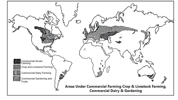
Specialized Horticulture and Floriculture (Flower Culture)
- Specialized horticulture and floriculture involves production of fruits, flowers and, vegetables in orchards and kitchen gardens solely for the urban market.
- Market gardening is well developed in the densely populated industrial districts of northwestern Europe— in Britain, Denmark, Belgium, Germany and the Netherlands, and in the northeastern U.S.A., where the demands are very high.
- In the southeast U.S.A., this type of farming is called truck farming because trucks are used to transport the fruits and vegetables from the farm to the buyers. In tropical region, truck farming may be established for climatic regions. Upland areas may produce temperate fruits and vegetables, which are in great demand in urban areas.
- The market gardens are located just outside the city in suburban areas or in areas where climatic and soil conditions are particularly favorable.
- The scale of farming is small and intensive Attention is paid to individual plants. Labour, capital and organization are intensively applied to land. During peak periods, farmers and their family members have to work almost round the clock.
- The methods employed to grow crops are generally traditional and since most of the work is done by hand the farming is labour intensive. Where soil is good and favouring early harvest, intensive labour and consummate human skill devoted to the growing of a large number of crops on minimum hectares.
Plantation Agriculture
- Plantation is a form of commercial agriculture found in the tropics and the subtropics of Latin America, Africa and Asia. It refers to the large scale, capitalised and often highly centralised cultivation in the plantations of cash crops for export. It is, therefore, one of the best examples of an export-oriented system.
- Among the most important crops found on plantations are cotton, sugarcane, coffee, rubber and tobacco. Latin American plantations are most likely to grow coffee, sugarcane and bananas while Asian plantations may provide rubber and palm oil.
- Most estates have foreign ownership but the labour employed is local. The largest estates are owned by the Europeans. For example, the Malaysian rubber plantations are owned by Europeans while the tapping and processing of the rubber is done entirely by local people or by immigrant labourers from southern India.
- The British established large tea gardens in India and Sri Lanka and banana and sugarcane plantations in West Indies. The French have established cocoa and coffee plantations in West Africa, e.g. in -Cameroon and Ivory Coast.
- The Dutch once monopolised the sugarcane plantations in Indonesia, especially in Java; Spanish and American capitalists invested in coconut, abaca and sugar plantations in the Philippines; the Portuguese still own fazendas in Brazil. Sugarcane plantations in Queensland, Australia are an exception in the sense that they employ white labour.
Indian Agriculture
- Agriculture plays a vital role in Indian economy.
- 6% of the population is engaged in agriculture and allied activities (census 2011) and it contributes 17.1% to the country’s Gross Value Added for the year 2017-18 (at current prices).
- India is the second largest fruit producer in the world. Production of horticulture crops is estimated at record 314.7 million tonnes (mt) in 2018-19 as per third advance estimates. India is also the largest producer, consumer and exporter of spices and spice products.
- India ranks second in agricultural output and India is in top five positions for about 80 percent of products produced from farm.
- The major research institute for agricultural research is Indian Council of Agricultural Research (ICAR).
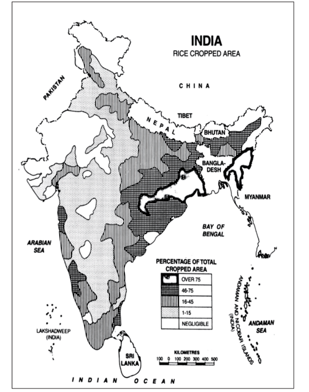
- The main food grain of India is Rice. India ranks second worldwide in rice production.
- West Bengal is the top state in rice production followed by Uttar Pradesh, Andhra Pradesh, Punjab, and Bihar.
- Yield wise, Tamil Nadu ranks first in rice production.
- Central rice research institute is located in Cuttack, Odisha.
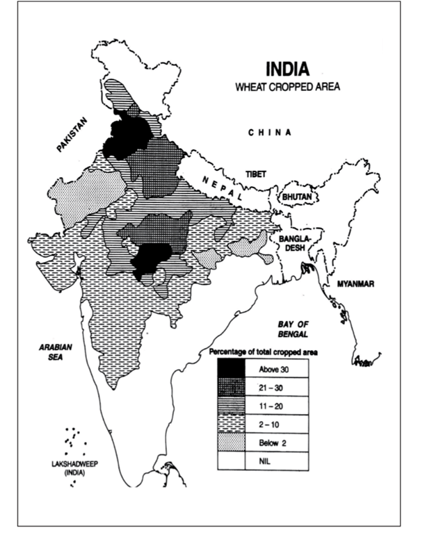
- India ranks second in wheat production.
- Uttar Pradesh is the highest wheat producing state of India followed by Punjab, Madhya Pradesh, and Haryana.
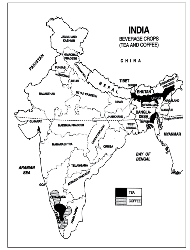
- India is the second most tea producing country and in India, Assam is the most tea producing state.
- Karnataka is the highest coffee producing state.
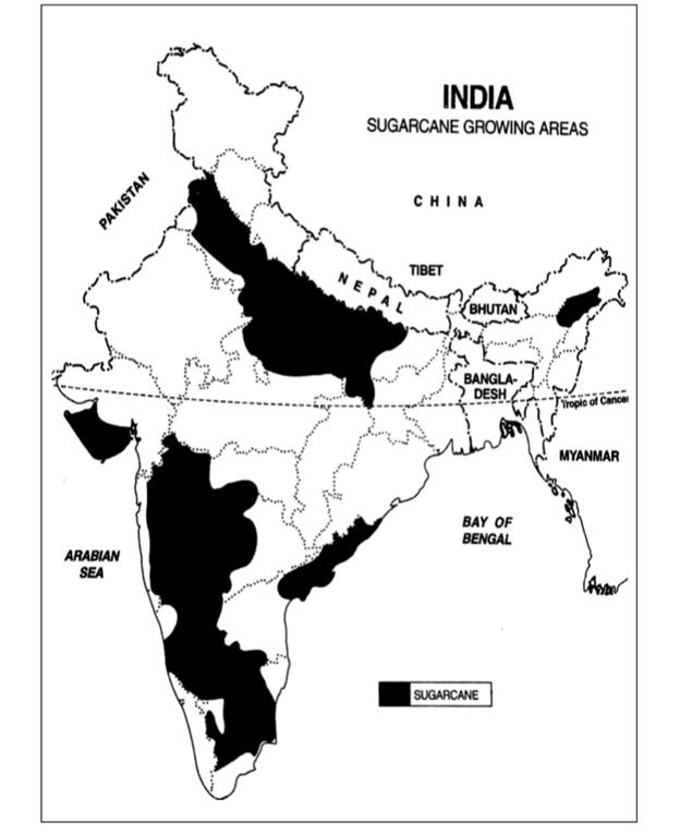
- Sugarcane is one of the main crops produced by India. Uttar Pradesh is the key state in producing sugarcane.
- Indian Institute of Sugarcane Research is located in Lucknow.
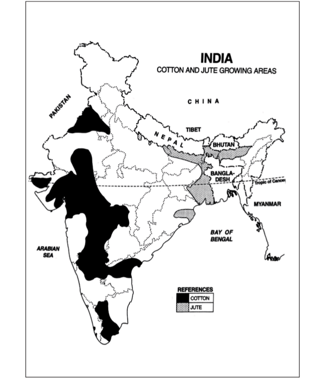
- Cotton and Jute are the main fiber crops produced in India. Maharashtra is the largest producer of cotton and West Bengal is the largest producer of Jute in India.
Salient Features of Indian Agriculture
Agriculture is the primary source of livelihood for about 58 per cent of India’s population. India has the 10th largest arable land resources in the world. With 20 Agro-climatic regions, all 15 major climates in the world exist in India. The country also possesses 46 of the 60 soil types in the world.
- Subsistence agriculture: Most parts of India have subsistence agriculture. The farmer owns a small piece of land, grows crops with the help of his family members and consumes almost the entire farm produce with little surplus to sell in the market.
- Pressure of population on agriculture: The population in India is increasing at a rapid pace and exerts heavy pressure on agriculture. While looking into the present need of food grains, we require an additional 12-15 million hectares of land to cope with the increasing demands.
- Importance of animals: Animal force has always played a significant role in agricultural operations such as ploughing, irrigation, threshing and transporting the agricultural produce.
- Dependent upon monsoon: Indian agriculture is mainly dependent upon monsoon which is uncertain, unreliable and irregular. Nearly 60% area is rainfed.
- Variety of crops: India is a vast country with varied types of relief, climate and soil conditions. Therefore, there is a large variety of crops grown in India. Both the tropical and temperate crops are successfully grown in India.
- Predominance of food crops: Since Indian agriculture has to feed a large population, production of food crops is the first priority of the farmers almost everywhere in the country. More than two-thirds of the total cropped area is devoted to the cultivation of food crops. More than 85 per cent of the net sown area is already under foodgrains.
- Insignificant place given to fodder crops: Although India has the largest population of livestock in the world; fodder crops are given a very insignificant place in our cropping pattern. Only four per cent of the reporting area is devoted to permanent pastures and other grazing lands.
- Mixed Cropping: Mixed cropping is one of the chief characteristics of Indian agriculture particularly in the rain-fed areas. The popular crops are millets, maize and pulses in the kharif season and wheat, gram and barley in the Rabi season.
- High percentage of reporting area under cultivation: In the year 2013-14, 141.43 million hectares was the net sown area out of total reporting area of 307.8 million hectares. Thus nearly 46 per cent of the total reporting area is under cultivation. This is a very high percentage when compared to some of the advanced countries like 16.3% in U.S.A., 14.9% in Japan, 11.8% in China, and only 4.3% in Canada.
- Labour intensive: In large part of India, agriculture is labour intensive as most of agricultural operations like ploughing, levelling, sowing, weeding, pruning, sprinkling, spraying, harvesting, threshing, etc. are done by the farmers and their animals.
Food grains
- The importance of foodgrains in Indian agricultural economy may be gauged from the fact these crops occupy about two-third of total cropped area in the country.
- Foodgrains are dominant crops in all parts of the country whether they have subsistence or commercial agricultural economy.
Cereals
- The cereals occupy more than half of the total cropped area in India.
- The country produces about 11 per cent cereals of the world and ranks third in production after China and U.S.A.
- India produces a variety of cereals, which are classified as fine grains (rice, wheat), and coarse grains (jowar, bajra, maize, ragi), etc. Account of important cereals has been given in the following paragraphs:
|
Major Crops |
Temperature |
Rainfall |
Soil |
Area |
Other |
|
Rice |
22-30 degree celsius |
150-300 cm |
Deep clayey and loamy soli |
West Bengal, Punjab, Uttar Pradesh Tamil Nadu, Haryana, Andhra Pradesh, Telangana and Kerala |
India contributes 21.6 per cent of rice production in the world and ranked second after China |
|
Wheat |
10-15 degree Celsius (sowing time) 21-26 degree Celsius (ripening & harvesting) |
75-100 cm |
Well drained fertile loamy and clayey loamy |
About 85 per cent of total area under this crop is concentrated in north and central regiouns of the country i.e. indo-gangetic Plain, Malwa Plateau and Himalayas up to 2,700 m Madhya Pradesh , Punjab Haryana & Rajasthan. |
Wheat is the second most important cereal crop in India produces about 12 per cent of total wheat production of world, it is primarily a crop of temperate zone. |
|
Jowar |
25-32 degree Celsius |
30-100 cm |
Can be grown in inferior alluvial or loamy soil |
Semi-arid areas of central and southern india, Maharashtra, Kamataka, Andhra Pradesh and Madhya Pradesh |
Jowar is the third most important food crop with respect to area and production, it is a rainfed crop mostly grown in the moist areas which hardly needs irrigation. |
|
Bajra |
25-30 degree celsius |
40-60 cm |
Grows well on sandy soil and shallow black soil |
Hot and dry climatic conditions in northwestern and western parts of the country Rajasthan, Uttar Pradesh Gujarat & Haryana |
It is a hardy crop which spells and drought in this region. It is cultivated alone as well as part of mixed cropping. |
|
Maize |
22-27 degree celsius |
50-100 cm |
Can be grown in inferior alluvial or loamy soil |
Grown under semi-arid climatic conditions, Chambal region, southem states kamataka, Madhya Pradesh, Bihar & Tamil Nadu. |
Maize is a food as well as fodder crop |
|
Pulses |
Both in Kharif and rabi season |
50-75 cm |
Can be grown in inferior alluvial or loamy soil |
Largely concentrated in the dry lands of Deccan and central plateaus and north western parts of the country |
India is the largest producer (about one fifth of world) as well as the consumer of pulses in the world, pulses occupy about 11 per cent of the total cropped ares in the country. |
|
Millets |
27-32 degree Celsius |
50-75 cm |
Can be grown in inferior alluvial or loamy soil |
Rain fed and dry region |
Drought resistant crop, high in nutrients |
|
Gram |
20-25 degree Celsius (Mild cool & Dry Climate) |
40-45 cm |
Loamy Soil |
Rain fed and dry region Rajasthan Madhya Pradesh uttar Pradesh |
|
|
Cotton |
21-30 degree Celsius |
50-100 cm |
Black soil of Deccan and Malwa Plateau |
Deccan and Malwa Plateau, Maharashtra, Tamil Nadu, Gujarat, Madhya Pradesh Karnataka |
India grows bot short staple (Indian) cotton as well as long staple (American) cotton called narma in north western parts of the country. Cotton requires clear sky during flowering stage. |
|
Oilseeds |
20-30 degree Celsius |
50-100 cm |
Well drained light sandy loams, red yellow and black soils |
Dry lands of Malwa plateau, Marathwada, Gujarat, Rajasthan, Telangana and Rayaiseema region of Andhya Pradesh and Kamataka plateau |
Groundnut, rapeseed and mustard soyabean and sunflower are the main oilseed crops grown in india. |
|
Tea |
20-30 degree celsius |
150-300 cm |
Undulating topography of hilly areas and well-drained soils in humid and sub-humid tropics and sub-tropics. |
Sub-Himalayan region of West Bengal (Darjeeling, Jalpaiguri and Cooch Bihar districts). Lower slopes of Nilgiri and Cardamom hills in Western, Brahmaputra valley of Assam |
India is ranked fourth in terms of tea exports, Assam produces almost 50% of country’s production |
|
Coffee |
15-28 degree celsius |
150-250 cm |
Well drained deep friable loamy soil |
Highlands of Western Ghats in Karnataka, Kerala and Tamil Nadu |
Karnataka alone accounts for more than two third of total production of coffee in the country. Indian coffee is known in the world for its good quality |
|
Jute |
24-35 degree celsius |
150-200 cm |
Grows well on well- drained fertile soils in the flood plains |
West Bengal and adjoining eastern parts of the country |
India produces about three-fifth of jute production of the world. West Bengal accounts of about three- fourth of the production in the country. Bihar and Assam are other jute growing areas. |
|
Sugarcane |
22-28degree celsius |
75-150 cm |
Indo -Gangetic plain |
Its cultivation is largely concentrated in Uttar Pradesh and Maharashtra, Tamil Nadu, Karnataka, Andhra Pradesh. |
India is the second largest producer of sugarcane after Brazil |
Major Crops Producing States of India
|
Crops |
States |
|
Rice |
West Bengal, Uttar Pradesh, Tamil Nadu, Andhra Pradesh, Punjab |
|
Wheat |
Uttar Pradesh, Haryana, Punjab, Madhya Pradesh |
|
Sugarcane |
Uttar Pradesh, Mharashtra, Karnataka |
|
Jowar |
Mharashtra, Karnataka, Madhya Pradesh, Telangana, Gujarat |
|
Bajra |
Rajasthan, Mharashtra, Gujarat |
|
Ragi |
Andhra Pradesh, Karnataka, Tamil Nadu |
|
Tea |
Assam, West Bengal, Himachal Pradesh |
|
Coffee |
Karnataka, Kerala, Tamil Nadu |
|
Cotton |
Maharashtra, Gujarat |
|
Jute |
West Bengal, Bihar, Assam |
|
Rubber |
Kerala, North East States |
|
Silk |
Karnataka, Kerala |
|
Maize |
Uttar Pradesh, Rajasthan, Madhya Pradesh, Bihar |
|
Gram |
Rajasthan |
|
Millets |
Madhya Pradesh |
|
Pulse |
Madhya Pradesh, Maharashtra, Uttar Pradesh, Rajasthan |
|
Tobacco |
Andhra Pradesh, Maharashtra |
|
Onion |
Maharashtra |
|
Groundnut |
Gujarat |
|
Banana |
Tamil Nadu |
|
Potato |
Uttar Pradesh |
|
Soils |
Crops |
|
1. Alluvial soils |
Wheat, maize, barley, gram, oilseeds, pulses, sugarcane. |
|
2. Clayey loams, fine and heavy soils |
Rice, Jute |
|
3. Volcanic black soils or regur |
Cotton, Wheat, oilseeds |
|
4. Sandy loams and sandy soils |
Jawar, bajra,groundnut, guar, pulses (green gram, red gram, black gram etc.) |
|
5. Red and yellow soils |
Jawar, groundnut, sugarcane. |
Agro-Climatic Regions
- Climate plays an important role in evolving crop ecology of a region and is responsible for regional variations in agriculture. Such variations are more prominent in a large country like India, where there are large variations in climatic elements. Effects of climatic elements are reflected in crop calendars, crop productivity and cropping patterns in different parts of the country.
- The Planning Commission divided India into 15 major agro-climatic regions in 1989. These regions are :
- The Western Himalayas
- The Eastern Himalayas
- The Lower Gangetic Plains
- The Middle Gangetic Plains
- The Upper Gangetic Plains
- The Trans-Gangetic Plain
- The Eastern Plateaus and Hills
- The Central Plateaus and Hills
- The Western Plateaus and Hills
- The Southern Plateaus and Hills
- The East Coastal Plains and Hills
- The West Coastal Plains and Western Ghats
- The Gujarat Plains and Hills
- The Western Dry Region
- The Islands Region.
Problems of Indian Agriculture
- Dependence on Erratic Monsoon: Irrigation covers only about 33 per cent of the cultivated area in India. The crop production in rest of the cultivated land directly depends on rainfall.
- Low productivity: The yield of the crops in the country is low in comparison to the international level. Per hectare output of most of the crops such as rice, wheat, cotton and oilseeds in India is much lower than that of U.S.A., Russia and Japan.
- Constraints of Financial Resources and Indebtedness: The inputs of modern agriculture are very expensive. This resource intensive approach has become unmanageable for marginal and small farmers as they have very meagre or no saving to invest in agriculture.
- Lack of Land Reforms: Indian peasantry had been exploited for a long time as there had been unequal distribution of land. After independence, land reforms were accorded priority, but these reforms were not implemented effectively due to lack of strong political will.
- Small Farm Size and Fragmentation of Landholdings: There are a large number of marginal and small farmers in the country. More than 60 per cent of the ownership holdings have a size smaller than one hectare. Furthermore, about 40 per cent of the farmers have Operational holding size smaller than 0.5 hectare. The average size of land holding is shrinking further under increasing population pressure. Furthermore, in India, the land holdings are mostly fragmented.
- Lack of Commercialization: A large number of farmers produce crops for self-consumption. These farmers do not have enough land resources to produce more than their requirement. Most of the small and marginal farmers grow foodgrains, which are meant for their own family consumption. Modernization and commercialization of agriculture have, however, taken place in the irrigated areas.
- Vast Under-employment: There is a massive under-employment in the agricultural sector in India, particularly in the un-irrigated tracts. In these areas, there is a seasonal unemployment ranging from 4 to 8 months. People engaged in agriculture do not have the opportunity to work round the year.
ENERGY RESOURCES
- Energy is the name given to the ability to do work.
- In order that anything may be done energy is required. All human life depends on energy in the universe.
- Most of the energy on the earth comes from the sun.
- It is the sun, which is the source of all forms of energy on the earth and related to the formation of energy fuels either directly or indirectly.
- It is the sun only, which makes all the motions on earth possible be it wind, wave or anything.
Types of Energy Resources
Commercial Energy Sources
Solid Fuels
- Hard coal: Coals with a gross calorific value (moist, ash-free basis) which is not less than 24 MJ/kg or which is less than 24 MJ/kg provided that the coal has a vitrinite mean random reflectance rather than or equal to 0.6 per cent. Hard coal comprises anthracite and bituminous coals.
- Lignite: Brown coal with a gross calorific value (moist, ash-free basis) less than 20 MJ/kg.
- Coke: Products derived directly or indirectly from the various classes of coal by carbonisation or pyrolysis processes, or by the aggregation of finely divided coal or by chemical reactions with oxidising agents, including water
Liquid Fuels
- Crude petroleum: A mineral oil of fossil origin extracted by conventional means from underground reservoirs, and comprises liquid or near-liquid hydrocarbons and associated impurities such as sulphur and metals.
- Liquefied Petroleum Gas: LPG refers to liquefied propane (C3H8) and butane (C4H10) or mixtures of both. Commercial grades are usually mixtures of the gases with small amounts of propylene, butylene, isobutene and isobutylene stored under pressure in containers.
- Motor gasoline: A mixture of some aromatics (e.g., benzene and toluene) and aliphatic hydrocarbons in the C5 to C12 range. The distillation range is 25°C to 220°C.
- Naphtha’s Light or medium oils distilling between 30°C and 210°C, which do not meet the specification for motor gasoline.
- Kerosene: Mixtures of hydrocarbons in the range C9 to C16 and distilling over the temperature interval 145°C to 300°C, but not usually above 250°C and with a flash point above 38°C.
- Gasoline type Jet fuels: Light hydrocarbons for use in aviation turbine power units, distilling between 100°C and 250°C. They are obtained by blending kerosene and gasoline or naphtha in such a way that the aromatic content does not exceed 25 per cent in volume and the vapour pressure is between 13.7 kPa and 20.6 kPa.
- Gas oil/Diesel oil: Gas oils are middle distillation; predominantly of carbon number range C11 to C25 and with a distillation range of 160°C to 420°C.
- Fuel oil: Comprises residual fuel oil and heavy fuel oil. Residual fuel oils have a distillation range of 350°C to 650°C and a kinematic viscosity in the range 6 to 55 cSt at 100°C. Their flash point is always above 60°C and their specific gravity is above 0.95. Heavy fuel oil is a general term describing a blended product based on the residues from various refinery processes.
Gaseous Fuels
- Natural Gas: It is mixture of gaseous hydrocarbons, primarily methane, but generally also including ethane, propane and higher hydrocarbons in much smaller amounts and some non-combustible gases such as nitrogen and carbon dioxide.
- Coke-oven gas: A gas produced from coke ovens during the manufacture of coke.
- Biogases: Gases arising from the anaerobic fermentation of biomass and the gasification of solid biomass (including biomass in wastes).
- The gases are divided into two groups according to their production: biogases from anaerobic fermentation and biogases from thermal processes. They are used mainly as a fuel but can be used as a chemical feedstock.
Non-commercial Energy Sources
- Fuelwood, wood residues and by-products: Fuelwood or firewood (in log, brushwood, pellet or chip form) obtained from natural or managed forests or isolated trees. Also included are wood residues used as fuel and in which the original composition of wood is retained.
- Remark: Charcoal and black liquor is excluded.
- Charcoal: The solid residue from the carbonization of wood or other vegetable matter through slow pyrolysis.
- Bagasse: The fuel obtained from the fibre, which remains after juice extracts in sugar cane processing.
Based on the availability in near future and replenishments, energy resources can be classified as:
- Non-renewable resources, which when exhausted are exhausted forever, and
- Renewable resources, which can also be called inexhaustible.
Other classification can be made between:
- Conventional, which has been in use by mankind for quite some time and which are more or less, direct form of energy.
- Non-conventional such as biogas, biomass in which one has to perform some processes before getting energy.
Natural Gas
- Natural gas is a naturally occurring hydrocarbon gas mixture consisting primarily of methane, but commonly includes varying amounts of other higher alkanes and even a lesser percentage of carbon dioxide, nitrogen, and hydrogen sulphide. Natural gas is an energy source often used for heating, cooking, and electricity generation. It is also used as fuel for vehicles and as a chemical feedstock in the manufacture of plastics and other commercially important organic chemicals.
- Natural gas is often informally referred to simply as gas, especially when compared to other energy sources such as oil or coal. However, it is not the same as gasoline, especially in North America, where the term gasoline is often shortened in colloquial usage to gas.
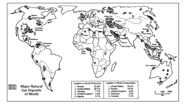
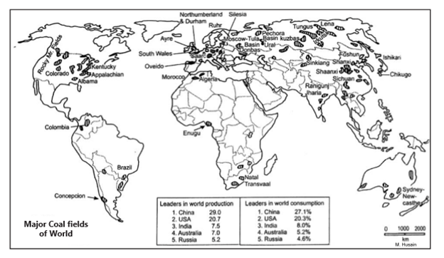
Major Natural Gas Deposits of the World
Natural gas as an energy source has certain merits and limitations.
Merits
- Burns clean compared to other energy resources.
- 70% loss carbon dioxide emission compared to other fossil fuel
- Helps improve quality of air and water (not a pollutant)
- Does not produce ashes after energy release
- Has high heating value of 24,000 Btu per pound
- Inexpensive compared to coal
- No odour until added
Limitations
- Natural gas is not a renewable source it is a finite resource trapped in the earth.
- Inability to recover all in-place gas from a producible deposit because of unfavorable economics and lack of technology (it costs more to recover the remaining natural gas because of flow, access, etc.)
Coal
- Coal is a sedimentary deposit formed by the slow action of heat and pressure on forests buried in the long past. It is a mechanical mixture of carbon, hydrogen, nitrogen, sulphur, etc. And it is the content of carbon which determines the quality of coal.
- In terms of fixed carbon, coals are classified into
- Anthracite (>95%)-As gas coal it is used for the manufacture of city gas with coke as a by-product.
- Bituminous (42-83%)-80% world’s coal output
- As coking coal it is used in coke ovens for the manufacture of metallurgical coke, with gas as a by- product.
- As household coal it is used for domestic heating purposes.
- Lignite or Brown’ coal (38%) - about 15% world’s coal output is from lignite.
- Having low heating capacity, it is sometimes used in steel plants.
- Sometime used as fuel in power plants and mainly it is used, as a soil conditioner.
- Peat (<38%).
Distribution of Coal
- North America
U.S.A.
-
- Eastern province (a) Pennsylvania anthracite field—Scranton, Carbondale and Wilkes Barre; (b) Appalachian bituminous field—Pittsburgh, Kentucky and West Virginia, Alabama and Tennessee
- The interior province (Bituminous)—(a) Eastern interior field—Illinois, Indiana and Kentucky (b) Western interior field—Iowa, Missouri, Oklahoma and Arkansas, (c) Northern interior field— Michigan (d) Southwestern fields— Texas.
- Gulf Province (lignite) Texas, Alabama and Arkansas
- Rocky Mountain Province (lignite and low-grade bituminous)—Utah, Colorado, Wyoming, Montana, New Mexico and North Dakota.
- Pacific Province—Washington, Oregon, California and Alaska
Canada
-
- Prairie Province—Alberta (bituminous & lignite); British Columbia Coalfields—Vancouver Islands; Nova Scotia Coal fields—Cape Breton Island
- Asia
-
- China— Shansi, Shensi, Inner Mongolia, Kansu, Hopei and Manchurian coalfields—Fushun (the world’s longest strip mines and have thickest seam recorded anywhere), Fushin, Kailan and Hegang.
- Japan— Chikugo coalfield in the northwestern Kyushu, Ishikari fields of Hokkaido and Joban and Ube in Honshu
- India— Damodar valley in the states of Bengal, Jharkhand, Orissa and important mines are Raniganj, Bokaro, Jharia. Smaller deposits are at Chanda, Singareni, Tundur and Pench.
- Pakistan— Quetta and Kalabagh;
- Iran—Kermanshah.
Energy Resources: India
Energy is now a major input in sectors such as industry. Commerce , transport and telecommunications, besides the wide range of services required in the household sector.
Conventional Sources of Energy
- Coal, petroleum, natural gas and electricity are conventional sources of energy.
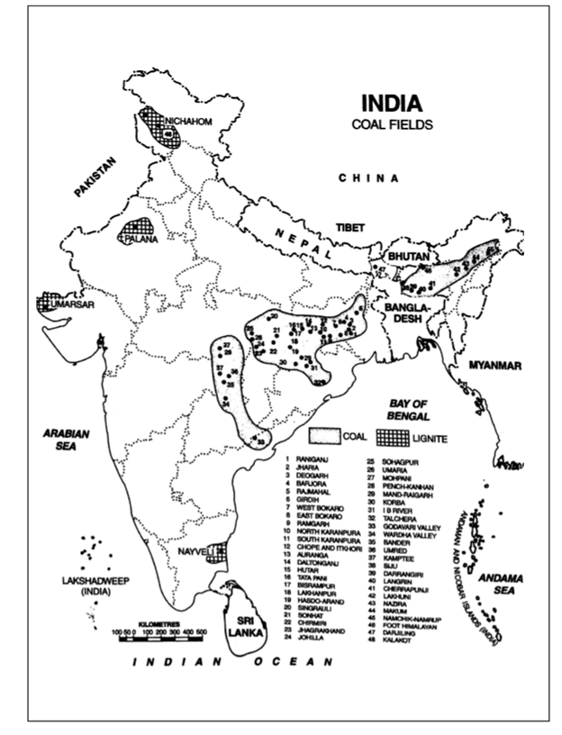
Occurrence of Coal in India:
The coal bearing strata of India are geologically classified into two main categories viz. the Gondwana coal fields and the Tertiary coal fields.
- Gondwana Coal- Gondwana coal contributes overwhelmingly large proportion of both the reserves and production of coal, accounting for 98 per cent of the total reserves and 99 per cent of the production of coal in India. It is the store house of India’s metallurgical as well as superior quality coal. Of the 113 major coal fields found all over India, 80 are located in the rock systems of the lower Gondwana Age.
- Tertiary Coal -The tertiary rock systems bears coals of younger age; from 15 to 60 million years and are mainly confined to the extra-Peninsula. This coal generally has low carbon and high percentage of moisture and Sulphur. Important areas of Tertiary coal include parts of Assam, Meghalaya, Arunachal Pradesh, Nagaland, Himalayan foothills of Darjeeling in West Bengal, Jammu and Kashmir, Uttar Pradesh. Rajasthan, Kerala, Tamil Nadu and the union territory of Puducherry.
Distribution of Coal in India
- Majority of the coal-fields are found in the eastern part of India particularly to the east of 78° E longitude. Maximum concentration of coal fields is in the north-eastern pan of the peninsular plateau of India comprising pans of Jharkhand and Chhattisgarh.
- Odisha and eastern Madhya Pradesh and western part of West Bengal adjoining Jharkhand.
- Southern part of Madhya Pradesh, eastern part of Andhra Pradesh and eastern coast also have large deposits.
- About three-fourth of India’s coal is produced by four states of Chhattisgarh, Jharkhand, Odisha and Madhya Pradesh.
- More than 40 per cent of India’s total coal production comes from just two states of Chhattisgarh and Jharkhand.
- About one-third of the total coal of the country is obtained from Andhra Pradesh, Maharashtra, West Bengal, Uttar Pradesh and Meghalaya.
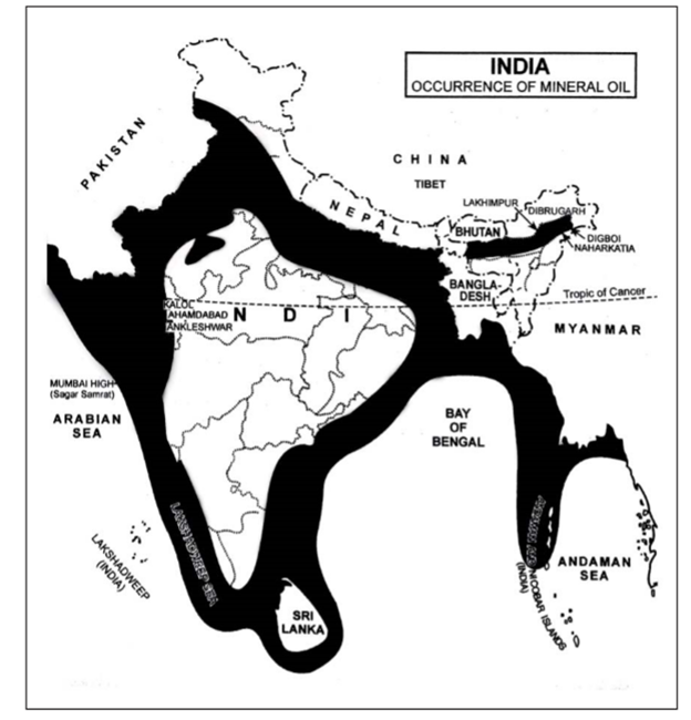
Petroleum & Mineral Oil
- Oil in India is obtained both from on-shore and off-shore areas, but off-shore areas made a major contribution.
On-shore Oil Production:
- On-shore oil fields are located in the Brahmaputra valley of north-cast India, Barmer area of Rajasthan, Gujarat coast in western India and Cauvery on-shore basin in Tamil Nadu. Besides Andhra Pradesh has both on-shore and off-shore oil reserves.
- One of the largest inland oil discoveries was made in Barmer district of Rajasthan in 2004. The oil block covers an area of approximately 5,000 sq km. State-of-the-art technology with innovative geological modelling was used in discovering this oil field.
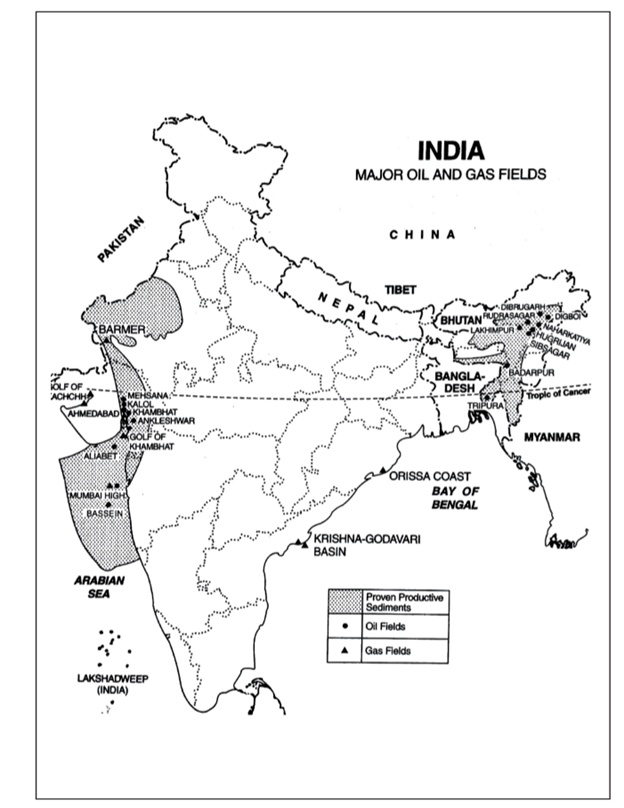
Western Coast Off-Shore Oil fields
- Extensive surveys have been conducted by ONGC in the offshore areas of Kachchh, Khambhat, Konkan, Malabar and Coromandal coasts, Krishna-Godavari delta and Sunderbans.
- Success on commercial scale has been achieved at Mumbai High, Bassein and Aliabet.
- Mumbai High: The greatest success achieved by the ONGC with respect to offshore surveys for oil was that of Mumbai High in 1974. It is located on the continental shelf off the coast of Maharashtra about 176 km north-west of Mumbai.
- Bassein: Located to the south of Mumbai High, this is a recent discovery endowed with reserves which may prove to be higher than those of the Mumbai High. Huge reserves have been found at a depth of 1,900 metre. Production has started and has picked up fast.
- Aliabet: It is located at Aliabet Island in the Gulf of Khambhat about 45 km off Bhavnagar. Huge reserves have been found in this field. Commercial production is expected to start soon.
Natural Gas
- Natural gas usually accompanies petroleum accumulations. Whenever a well for oil is drilled, it is natural gas which is available before oil is struck. Natural gas is fast becoming an important source of energy in India. The recoverable reserves of natural gas as on 1 April 2003 were around 700 BCM (billion cubic meter).
- The estimated production of natural gas was 118 million metric standard cubic metres per day in 2012-13 the major part of which came from off-shore areas. Assam, Gujarat, Andhra Pradesh and Tamil Nadu are the major on-shore producing states.
- Discovery of gas made rapid strides after 1985. Oil strikes at Cauvery off-shore and at Nanda in Khambhat basin as also gas found at Talot in Jaisalmer Basin in Rajasthan were major discoveries during 1988-89. Production from South Bassein Gas Field started in September 1988.
- During 1989-90 oil gas structures had been discovered in AdIyakkamanglam in Tamil Nadu, Andada in Gujarat, Khovaghat in Assam, Lingla in Andhra Pradesh.
- Mumbai off-shore and Kachchh offshore reserve. Another survey conducted in 1997 in the Andamans has revealed 1.700 billion cubic feet of gas reserves which can meet the country’s requirements for the next 30 years.
Nuclear Energy
- Nuclear energy is obtained from uranium and thorium. India has vast untapped uranium resources and there is urgent need to make use of these resources if India really wants to get out of the Present scenario of power shortages and energy crisis.
- Although nuclear power contributes only a little over 3 Percent of our total power generation at present, it has vast potential for future development.
- It requires quite higher technology to develop nuclear which India has fortunately attained now. India is one of the few countries which have developed the capability of designing, constructing, commissioning and operating a nuclear power station without any help from outside.
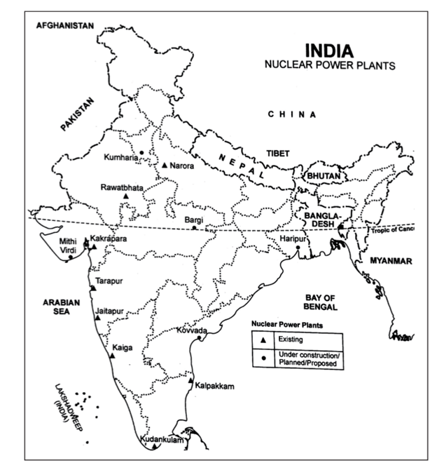
- Most of the nuclear power stations in India have been constructed near sources of water required in great quantity for cooling purposes.
Non-Conventional Energy Sources
- With increasing demand for energy and with fast depleting conventional sources of energy such as coal, petroleum, natural gas. Etc. the non-conventional sources of energy such as energy from sun, wind, biomass, tidal energy, geo-thermal energy and even energy from waste material are gaining importance.
- This energy is abundant, renewable, pollution free and eco-friendly. It can be more conveniently supplied to urban, rural and even remote areas. Thus it is capable of solving the twin problems of energy supply in a decentralized manner and helping in sustaining cleaner environment. It is the energy of the future.
Solar Energy
- The radiation from the Sun is capable of producing heat, causing chemical reactions, or generating electricity.
- The total amount of solar energy incident on Earth is vastly in excess of the world’s current and anticipated energy requirements.
- If suitably harnessed, this highly diffused source has the potential to satisfy all future energy needs.
- In the 21st century solar energy is expected to become increasingly attractive as a renewable energy source because of its inexhaustible supply and its nonpolluting character, in stark contrast to the finite fossil fuels coal, petroleum, and natural gas.
- It is an important source of renewable energy and its technologies are broadly characterized as either passive solar or active solar depending on how they capture and distribute solar energy or convert it into solar power.
- Active solar techniques include the use of photovoltaic systems, concentrated solar power and solar water heating to harness the energy.
- Passive solar techniques include orienting a building to the Sun, selecting materials with favorable thermal mass or light-dispersing properties, and designing spaces that naturally circulate air.
Wind Energy
- Wind is another important source of non-conventional energy. The cost inputs are only at the initial stage and the power generation starts immediately after commissioning.
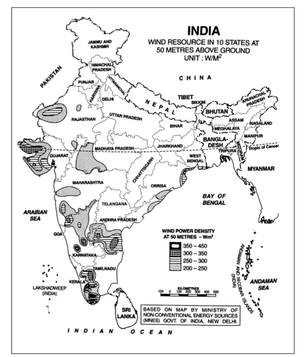
- Once the generation starts, cost-free power is available for about 20 years because there is no recurring cost on fuel. India has vast wind potential and wind farms have emerged as a viable option with the advancement of wind technology in the country.
- Since 1985, the Indian Government has carried out an extensive wind monitoring and mapping program to identify better sites and to assess the resource potential.
- The program has been implemented in a very systematic manner. The compiled data has been analyzed and is being published with the ultimate objective of preparing a wind atlas of the country. This data has been utilized in identifying some excellent sites for wind farms.
Cyclone 'IDAI'
Context
The Indian Navy was the first to respond cyclone Idai, a category 4 tropical storm, which hit southern Africa, is the worst weather-related disaster to hit the southern hemisphere.
About
More on News
- Cyclone 'IDAI' made landfall at Beira, Mozambique in early hours of 15 March 2019 causing widespread damage and loss of human life in the Central and Northern provinces of the country.
- The situation is being monitored closely and the Indian Navy is prepared to render all necessary assistance to the local population in Mozambique.
- Ships of First Training squadron of Indian Navy, Sujata, Sarathi and Shardul, operating in Southern Indian Ocean were diverted to Port Beira in Mozambique based on the request of the Government of Mozambique.
- The Indian Navy has made HADR (Humanitarian Assistance and Disaster Relief) assistance a major tool of its foreign cooperation initiative in the Indian Ocean Region (IOR) which has a high incidence of natural disasters.
Tropical Cyclones
- Tropical Cyclones are low pressure systems that form over warm tropical waters and have gale force winds (sustained winds of 63 km/h or greater and gusts in excess of 90 km/h) near the centre.
- They derive their energy from the warm tropical oceans and do not form unless the sea-surface temperature is above 26.5°C.
- Once formed, they can persist over lower sea-surface temperatures.
- Tropical cyclones can persist for many days and may follow quite erratic paths. They usually dissipate over land or colder oceans.
- The circular eye or centre of a tropical cyclone is an area characterised by light winds and often by clear skies. Eye diameters are typically 40 km but can range from under 10 km to over 100 km.
- The eye is surrounded by a dense ring of cloud about 16 km high known as the eye wall which marks the belt of strongest winds and heaviest rainfall
- Tropical Cyclones are dangerous because they produce destructive winds, heavy rainfall with flooding and damaging storm surges that can cause inundation of low-lying coastal areas.
Categories of tropical cyclone:
The severity of a tropical cyclone is described in terms of categories ranging from 1 to 5 related to the zone of maximum winds. Using this severity scale, communities will be able to assess the degree of cyclone threat and take appropriate action. A gale is a strong wind, typically used as a descriptor in nautical contexts.
- Category 1: Less than 125 km/h Gales - Minimal house damage. Damage to some crops, trees and caravans. Boats may drag moorings.
- Category 2: 125 - 164 km/h Destructive winds - Minor house damage. Significant damage to signs, trees and caravans. Heavy damage to some crops. Risk of power failure. Small boats may break moorings.
- Category 3: 165 - 224 km/h Very destructive winds - Some roof and structural damage.
- Category 4: 225 - 279 km/h Very destructive winds - Significant roofing and structural damage
- Category 5: More than 280 km/h extremely destructive winds - Extremely dangerous with widespread destruction.
International Workshop on Disaster Resilient Infrastructure
Context
International Workshop on Disaster Resilient Infrastructure is being is being organised by the National Disaster Management Authority (NDMA) in collaboration with United Nations Office for Disaster Risk Reduction (UNISDR), and in partnership with the Global Commission on Adaptation, United Nations Development Programme and the World Bank.
About
- The workshop will bring together countries from different parts of the world, multilateral development banks, UN agencies, academia and research institutions, the private sector, academics and policy think tanks to discuss and collaborate on promoting policies and practices towards achieving disaster resilience of large infrastructure systems (transport, telecom, energy, water). This will also be a great opportunity to learn from the unique experiences of different countries.
- Various international agreements have also reiterated the importance and long-term benefits of investing in resilient infrastructure.
- The first International Workshop on Disaster Resilient Infrastructure (IWDRI 2018) was held in January 2018.
The workshop aims to:
- Identify good practices of disaster risk management in key infrastructure sectors,
- Identify specific areas and pathways for collaborative research on DRI (Transport, Energy, Telecom and Water),
- Discuss and co-create the broad contours of the Coalition for Disaster Resilient Infrastructure (CDRI) as well as a notional roll-out plan for the next three years, and
- Build a forum for members to work on areas of common interest and make specific commitments.
The main objectives of the workshop are to:
- Take stock of impact of disasters on different infrastructure sectors and good practices in making infrastructure disaster resilient;
- Identify critical gaps in current practices that need to be addressed in the coming years; and
- Identify good practices and potential areas of collaboration along four themes:
- Development of risk assessment methodologies, risk metrics and indicators of sustainability for different infrastructure classes;
- Issues of standards, design and regulation for infrastructure development, operations and maintenance;
- Financing for disaster resilient infrastructure including risk transfer mechanisms; and
- Reconstruction and recovery of key infrastructure sectors after disasters.
Flood Management and Border Areas Programme (FMBAP)
Context
Cabinet approves “FMBAP” for Flood Management Works in entire country and River Management Activities and works related to Border Areas during 2017-18 to 2019-20.
About
- The Scheme "FMBAP" has been framed by merging the components of two continuing XII Plan schemes titled "Flood Management Programme (FMP)" and "River Management Activities and Works related to Border Areas (RMBA)".
- The aim of the Scheme is to assist the State Governments to provide reasonable degree of protection against floods in critical areas by adopting optimum combination of structural and non-structural measures and enhancing capabilities of State / Central Government officials in related fields.
Features-
- The works under the scheme will protect valuable land from erosion and flooding and help in maintaining peace along the border.
- The Scheme aims at completion of the on-going projects already approved under FMP. Further, the scheme also caters to Hydro-meteorological observations and Flood Forecasting on common rivers with the neighbouring countries.
- The Scheme also includes survey and investigations, preparation of DPR etc. of water resources projects on the common rivers with neighbouring countries like Pancheshwar Multipurpose Project, Sapta Kosi-Sun Kosi Projects in Nepal which would benefit both countries.
Funding pattern-
- The funding pattern for FM Component for works in general category States will continue to be 50% (Centre) : 50% (State) and for projects of North Eastern States, Sikkim, J&K, Himachal Pradesh and Uttarakhand, the funding pattern will continue to be 70% (Centre) : 30% (State).
Benefits-
- It will be implemented throughout the country for effective flood management, erosion control and anti-sea erosion.
- The proposal will benefit towns, villages, industrial establishments, communication links, agricultural fields, infrastructure etc. from floods and erosion in the country.
- The catchment area treatment works will help in reduction of sediment load into rivers.
Voting Rights For Under Trials

Cassation Bench Of SC
Puducherry: Administrator Not Supreme

Transperson: Right To Marry
Service Voters