Geography: Landforms and its Evolution
Landforms and its Evolution
- As the geomorphic agents are capable of erosion and deposition, two sets - erosional or destructional and depositional or constructional - of landforms are produced by them.
- Many varieties of landforms develop by the action of each of the geomorphic agents depending upon especially the type and structure i.e. folds, faults, joints, fractures, hardness and softness, permeability and impermeability, etc.
- There are some other independent controls like stability of sea level; tectonic stability of landmasses; climate, which influence the evolution of landforms.
Landforms Made by Running Water
- In humid regions, which receive heavy rainfall, running water is considered the most important of the geomorphic agents in bringing about the degradation of the land surface.
- Most of the erosional landforms made by running water are associated with vigorous and youthful rivers flowing over steep gradients.
The Course of a River
Youth
- Streams are few during this stage with poor integration and flow over original slopes showing shallow V-shaped valleys with no floodplains or with very narrow floodplains along trunk streams. Streams divides are broad and fat with marshes, swamp and lakes. Meanders if present develop over these broad upland surfaces. These meanders may eventually entrench themselves into the uplands. Waterfalls and rapids may exist where local hard rock bodies are exposed.
Mature
- During this stage streams are plenty with good integration. The valleys are still V-shaped but deep; trunk streams are broad enough to have wider floodplains within which streams may flow in meanders confined within the valley. The fat and broad inter stream areas and swamps and marshes of youth disappear and the stream divides turn sharp. Waterfalls and rapids disappear.
Old
- Smaller tributaries during old age are few with gentle gradients. Streams meander freely over vast floodplains showing natural levees, oxbow lakes, etc. Divides are broad and fat with lakes, swamps and marshes. Most of the landscape is at or slightly above sea level.
Erosional Landforms
Valleys:
- Valleys start as small and narrow rills; the rills will gradually develop into long and wide gullies; the gullies will further deepen, widen and lengthen to give rise to valleys.
- Depending upon dimensions and shape, many types of valleys like V-shaped valley, gorge, canyon, etc. can be recognized.
- A gorge is a deep valley with very steep to straight sides and a canyon is characterised by steep step-like side slopes and may be as deep as a gorge.
- A gorge is almost equal in width at its top as well as its bottom. In contrast, a canyon is wider at its top than at its bottom. In fact, a canyon is a variant of gorge.
- Valley types depend upon the type and structure of rocks in which they form. For example, canyons commonly form in horizontal bedded sedimentary rocks and gorges form in hard rocks.
Potholes and Plunge Pools:
- Over the rocky beds of hill-streams more or less circular depressions called potholes form because of stream erosion aided by the abrasion of rock fragments.
- Once a small and shallow depression forms, pebbles and boulders get collected in those depressions and get rotated by flowing water and consequently the depressions grow in dimensions.
- A series of such depressions eventually join and the stream valley gets deepened. At the foot of waterfalls also, large potholes, quite deep and wide, form because of the sheer impact of water and rotation of boulders.
- Such large and deep holes at the base of waterfalls are called plunge pools. These pools also help in the deepening of valleys.
- Waterfalls are also transitory like any other landform and will recede gradually and bring the floor of the valley above waterfalls to the level below.
Incised or Entrenched Meanders
- In streams that flow rapidly over steep gradients, normally erosion is concentrated on the bottom of the stream channel.
- Also, in the case of steep gradient streams, lateral erosion on the sides of the valleys is not much when compared to the streams flowing on low and gentle slopes.
- Because of active lateral erosion, streams flowing over gentle slopes develop sinuous or meandering courses.
- It is common to find meandering courses over floodplains and delta plains where stream gradients are very gentle.
- But very deep and wide meanders can also be found cut in hard rocks. Such meanders are called incised or entrenched meanders.
- Meander loops develop over original gentle surfaces in the initial stages of development of streams and the same loops get entrenched into the rocks normally due to erosion or slow, continued uplift of the land over which they start.
- They widen and deepen over time and can be found as deep gorges and canyons in hard rock areas.
- They give an indication on the status of original land surfaces over which streams have developed.
River Terraces
- River terraces are surfaces marking old valley floor or floodplain levels.
- They may be bedrock surfaces without any alluvial cover or alluvial terraces consisting of stream deposits. River terraces are basically products of erosion as they result due to vertical erosion by the stream into its own depositional floodplain.
- There can be a number of such terraces at different heights indicating former river bed levels.
- The river terraces may occur at the same elevation on either side of the rivers in which case they are called paired terraces.
Depositional Landforms
Alluvial fans
- Alluvial fans are formed when streams flowing from higher levels break into foot slope plains of low gradient.
- Normally very coarse load is carried by streams flowing over mountain slopes.
- This load becomes too heavy for the streams to be carried over gentler gradients and gets dumped and spread as a broad low to high cone shaped deposit called alluvial fan.
- Usually, the streams which flow over fans are not confined to their original channels for long and shift their position across the fan forming many channels called distributaries.
- Alluvial fans in humid areas show normally low cones with gentle slope from head to toe and they appear as high cones with steep slope in arid and semi-arid climates.
Deltas
- Deltas are like alluvial fans but develop at a different location.
- The load carried by the rivers is dumped and spread into the sea. If this load is not carried away far into the sea or distributed along the coast, it spreads and accumulates as a low cone.
- Unlike in alluvial fans, the deposits making up deltas are very well sorted with clear stratification.
- The coarsest materials settle out first and the finer fractions like silts and clays are carried out into the sea.
- As the delta grows, the river distributaries continue to increase in length and delta continues to build up into the sea
Floodplains
- Deposition develops a floodplain just as erosion makes valleys.
- Floodplain is a major landform of river deposition. Large sized materials are deposited first when stream channel breaks into a gentle slope.
- Thus, normally, fine sized materials like sand, silt and clay are carried by relatively slow moving waters in gentler channels usually found in the plains and deposited over the bed and when the waters spill over the banks during flooding above the bed.
- A river bed made of river deposits is the active floodplain. The floodplain above the bank is inactive floodplain.
- Inactive floodplain above the banks basically contain two types of deposits — flood deposits and channel deposits.
- In plains, channels shift laterally and change their courses occasionally leaving cut-of courses which get filled up gradually.
- Such areas over flood plains built up by abandoned or cut-of channels contain coarse deposits.
- The flood deposits of spilled waters carry relatively finer materials like silt and clay.
- The flood plains in a delta are called delta plains.
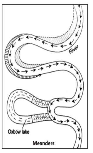
Meanders
- In large flood and delta plains, rivers rarely flow in straight courses.
- Loop-like channel patterns called meanders develop over food and delta plains.
- Meander is not a landform but is only a type of channel pattern.
- This is because of (i) propensity of water flowing over very gentle gradients to work laterally on the banks; (ii) unconsolidated nature of alluvial deposits making up the banks with many irregularities which can be used by water exerting pressure laterally; (iii) coriolis force acting on the fluid water defecting it like it defects the wind.
- When the gradient of the channel becomes extremely low, water flows leisurely and starts working laterally.
- Slight irregularities along the banks slowly get transformed into a small curvature in the banks; the curvature deepens due to deposition on the inside of the curve and erosion along the bank on the outside.
- If there is no deposition and no erosion or undercutting, the tendency to meander is reduced. Normally, in meanders of large rivers, there is active deposition along the concave bank and undercutting along the convex bank.
- The concave bank is known as cut-of bank which shows up as a steep scarp and the convex bank presents a long, gentle profile. As meanders grow into deep loops, the same may get cut-of due to erosion at the infection points and are left as ox-bow lakes.
Landform Made by Groundwater
- The surface water percolates well when the rocks are permeable, thinly bedded and highly jointed and cracked.
- After vertically going down to some depth, the water under the ground flows horizontally through the bedding planes, joints or through the materials themselves.
- It is this downward and horizontal movement of water which causes the rocks to erode.
- Physical or mechanical removal of materials by moving groundwater is insignificant in developing landforms. That is why; the results of the work of groundwater cannot be seen in all types of rocks. But in rocks like limestone’s or dolomites rich in calcium carbonate, the surface water as well as groundwater through the chemical process of solution and precipitation deposition develops varieties of landforms.
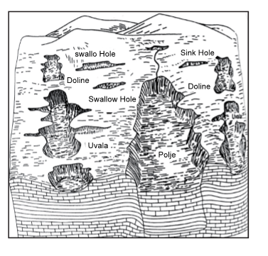
- Any limestone or dolomitic region showing typical landforms produced by the action of groundwater through the processes of solution and deposition is called Karst topography after the typical topography developed in limestone rocks of Karst region in the Balkans adjacent to Adriatic Sea.
- The karst topography is also characterised by erosional and depositional landforms.
Erosional Landforms
Pools, Sinkholes, Lapies and Limestone Pavements
- Small to medium sized round to sub-rounded shallow depressions called swallow holes form on the surface of limestones through solution.
- Sinkholes are very common in limestone/karst areas. A sinkhole is an opening more or less circular at the top and funnel-shaped towards the bottom with sizes varying in area from a few sq. m to a hectare and with depth from a less than half a meter to thirty meters or more.
- Some of these form solely through solution action (solution sinks) and others might start as solution forms first and if the bottom of a sinkhole forms the roof of a void or cave underground, it might collapse leaving a large hole opening into a cave or a void below (collapse sinks). Quite often, sinkholes are covered up with soil mantle and appear as shallow water pools. Anybody stepping over such pools would go down like it happens in quick sands in deserts.
- The term doline is sometimes used to refer the collapse sinks. Solution sinks are more common than collapse sinks. Quite often the surface run-of simply goes down swallow and sink holes and flow as underground streams and re-emerge at a distance downstream through a cave opening.
- When sink holes and dolines join together because of slumping of materials along their margins or due to roof collapse of caves, long, narrow to wide trenches called valley sinks or Uvalas form.
- Gradually, most of the surface of the limestone is eaten away by these pits and trenches, leaving it extremely irregular with a maze of points, grooves and ridges or lapies. Especially, these ridges or lapies form due to differential solution activity along parallel to sub parallel joints. The lapie field may eventually turn into somewhat smooth limestone pavements.
Caves
- In areas where there are alternating beds of rocks (shales, sandstones, quartzites) with limestones or dolomites in between or in areas where limestones are dense, massive and occurring as thick beds, cave formation is prominent. Water percolates down either through the materials or through cracks and joints and moves horizontally along bedding planes. It is along these bedding planes that the limestone dissolves and long and narrow to wide gaps called caves result. There can be a maze of caves at different elevations depending upon the limestone beds and intervening rocks. Caves normally have an opening through which cave streams are discharged. Caves having openings at both the ends are called tunnels.
Depositional Landforms
- Many depositional forms develop within the limestone caves. The chief chemical in limestone is calcium carbonate which is easily soluble in carbonated water (carbon dioxide absorbed rainwater). This calcium carbonate is deposited when the water carrying it in solution evaporates or loses its carbon dioxide as it trickles over rough rock surfaces.
Stalactites, Stalagmites and Pillars
- Stalactites hang as icicles of different diameters. Normally they are broad at their bases and taper towards the free ends showing up in a variety of forms.
- Stalagmites rise up from the floor of the caves. In fact, stalagmites form due to dripping water from the surface or through the thin pipe, of the stalactite, immediately below it.
- Stalagmites may take the shape of a column, a disc, with either a smooth, rounded bulging end or a miniature crater like depression.
- The stalagmite and stalactites eventually fuse to give rise to columns and pillars of different diameters.
Landform Made by Wind
- Wind is a geomorphic agent in all terrestrial environments. It is a potent agent only in dry areas with fine-grained soils and sediments and little or no vegetation. It is limited by a protective cover of vegetation and moist soil, which helps to bind soil particles together. Winds may erode, transport, and deposit materials, and are effective agents in regions with sparse vegetation and a large supply of unconsolidated sediments. Although water is a much more powerful eroding force than wind, Aeolian processes are important in arid environments such as deserts.
- Wind can erode desert rocks in two ways:
- Deflation: the removal of fine, loose particles from the surface of rocks.
- Abrasion: small particles being carried by the wind scrape of particles from the rock surface. It then transports the eroded material by three processes:
- Suspension: very small particles (<0.15mm) are picked up and carried by the wind.
- Saltation: small particles (0.15-0.25mm) are temporarily lifted from the ground and bounce along the surface.
- Surface Creep: larger particles (>0.25mm) are hit and pushed along the ground by particles being moved by saltation.
Erosional Landforms
Yardangs:
Yardangs are narrow, streamlined ridges that are usually three to four times longer than they are wide. They are made up of long ridges of hard resistant rocks alternating with narrow furrows of soft rocks. Here, both the bands of hard and soft rocks aligned vertically to the direction of the blowing prevailing winds. The process of abrasion is accelerated in the course of the blowing prevailing winds, assisting in wearing the soft bands of rocks into narrow corridors between the hard layers. Eventually, the bands of hard rocks remain standing high above the soft bands that have been worn into narrow corridors.
Zeugen:
A zeugen is a tabular mass of resistant rock, standing prominently in the desert. It is usually composed of alternating layers of hard and soft rocks. These alternating bands of rock usually lie horizontal on top of one and another. The softer rock layer usually lies beneath a surface layer of more resistant rock. The sculpturing effects of wind abrasion wear them into a furrow and ridge looking landscape. Insolation weathering enhances this activity.
Playas:
Playas are by far the most prominent landforms in the deserts. In basins with mountains and hills around and along, the drainage is towards the centre of the basin and due to gradual deposition of sediment from basin margins, a nearly level plain forms at the centre of the basin. In times of suficient water, this plain is covered up by a shallow water body. Such types of shallow lakes are called as playas where water is retained only for short duration due to evaporation and quite often the playas contain good deposition of salts. The playa plain covered up by salts is called alkali fiats.
Deflation Hollows and Caves:
Weathered mantle from over the rocks or bare soil, gets blown out by persistent movement of wind currents in one direction. This process may create shallow depressions called deflation hollows. Deflation also creates numerous small pits or cavities over rock surfaces. The rock faces suffer impact and abrasion of wind-borne sand and first shallow depressions called blow outs are created, and some of the blow outs become deeper and wider fit to be called caves.
Mushroom, Table and Pedestal Rocks: Many rock-outcrops in the deserts easily susceptible to wind deflation and abrasion are worn out quickly leaving some remnants of resistant rocks polished beautifully in the shape of mushroom with a slender stalk and a broad and rounded pear shaped cap above. Sometimes, the top surface is broad like a table top and quite often, the remnants stand out like pedestals.
Depositional Landforms
Wind is a good sorting agent. Depending upon the velocity of wind, different sizes of grains are moved along the floors by rolling or Saltation and carried in suspension and in this process of transportation itself, the materials get sorted. When the wind slows or begins to die down, depending upon sizes of grains and their critical velocities, the grains will begin to settle. So, in depositional landforms made by wind, good sorting of grains can be found. Sand accumulations come in a range of sizes and forms. Deposition may occur as sheets of sand (dune fields and sand seas) or loess or as characteristic dunes.
Ripples: Wind ripples are the smallest Aeolian bed form. They are regular, wave like undulations lying at right-angles to the prevailing wind direction.
Loess: Loess is terrestrial sediment composed largely of windblown silt particles made of quartz. It covers some 5-10 per cent of the Earth’s land surface, much of it forming a blanket over pre-existing topography that may be up to 400 m thick. Loess requires three things:
-
- a source of silt;
- wind to transport the silt; and
- a suitable site for deposition and accumulation
Dunes: Dunes are collections of loose sand built piece meal by the wind. They usually range from a few metres across and a few centimetres high to 2 km across and 400m high. Sand dunes form where there is a source of sand. Dune sand is usually composed of quartz, which is extremely hard and doesn’t easily decay. Dune sand grains are beautifully rounded by abrasion.
Crescent shaped dunes called barchans with the points or wings directed away from wind direction i.e., downwind, form where the wind direction is constant and moderate and where the original surface over which sand is moving is almost uniform. Parabolic dunes form when sandy surfaces are partially covered with vegetation. That means parabolic dunes are reversed barchans with wind direction being the same.
Seif also called linear dunesis similar to barchans with a small difference. Seif has only one wing or point. This happens when there is shift in wind conditions. The lone wings of seifs can grow very long and high. Longitudinal dunes form when supply of sand is poor and wind direction is constant. They appear as long ridges of considerable length but low in height.
Transverse dunes are aligned perpendicular to wind direction. These dunes form when the wind direction is constant and the source of sand is an elongated feature at right angles to the wind direction. They may be very long and low in height. When sand is plenty, quite often, the regular shaped dunes coalesce and lose their individual characteristics. Most of the dunes in the deserts shift and a few of them will get stabilised especially near human
Coastal Landforms
Coastal processes are among the most dynamic geologic processes; change in the morphology of many coasts can be observed on annual (or shorter) time scales. The ever-pounding waves generated by winds at sea release tremendous quantities of energy along continental margins, constantly shaping coasts. Other than the action of waves, the coastal landforms depend upon (i) the configuration of land and sea floor; (ii) whether the coast is advancing (emerging) seaward or retreating (submerging) landward.
Coastlines of Emergence
- These are formed either by an uplift of the land or by the lowering of the sea level.
- Bars, spits, lagoons, salt marshes, beaches, sea cliffs and arches are the typical features.
- The east coast of India, especially its south-eastern part (Tamil Nadu coast), appears to be a coast of emergence.
- The west coast of India, on the other hand, is both emergent and submergent.
- The northern portion of the coast is submerged as a result of faulting and the southern portion, that is the Kerala coast, is an example of an emergent coast.
Coastlines of Submergence
- A submerged coast is produced either by subsidence of land or by a rise in sea level.
- Ria, fjord, Dalmatian and drowned lowlands are its typical features.
Erosional Coastal Landforms
- Cliff s, Terraces, Caves and Stacks
- A sea cliff is a vertical precipice created by waves crashing directly on a steeply inclined slope. Hydraulic action, abrasion, and chemical solution all work to cut a notch at the high water level near the base of the cliff. Constant undercutting and erosion causes the cliff s to retreat landward.
- Sea caves form along lines of weakness in cohesive but well-jointed bedrock. Sea caves are prominent headlands where wave refraction attacks the shore.
- A sea arch forms when sea caves merge from opposite sides of a headland. If the arch collapses, a pillar of rock remains behind as a sea stack.
- Seaward of the retreating cliff s, wave erosion forms a broad erosional platform called a wave-cut bench or wave-cut platform. After the constant grinding and battering, eroded material is transported to adjacent bays to become beaches or seaward coming to rest as a wave-built terrace. If tectonic forces raise the bench above the water level a marine terrace forms. Some shorelines have several marine terraces creating during various episodes of uplift.
Depositional Coastal Landforms
- Beaches
- A beach is a deposit of loose sediment adjacent to a body of water. Though sand is common to most beaches, a remarkable diversity of sediment size, from boulders to fine silt is found on beaches around the world. Larger particles and steeper slopes are found where wave action is high. Fine particles and gentle slopes are characteristic of beaches exposed to low wave action.
- Most mid latitude beaches undergo a cycle of erosion and deposition following the seasonal changes in wave action. During the winter, mid latitude storms are more vigorous producing more wave action and erosion. Hence, beaches tend to narrow during the winter. Wave action subsides during the summer as storms weaken somewhat favoring deposition over erosion and producing broader beaches.
- Spits and Bars
- Sand spit is one of the most common coastal landforms. A sand spit is a linear accumulation of sediment that is attached to land at one end. Sand carried parallel to shore by long shore drift may eventually extend across a bay or between headlands especially where water is relatively calm. Spits are typically elongate, narrow features built to several dozen feet by wind and waves.
- Spits often form when wave energy decreases as a result of wave refraction in a bay. When a coastline turns abruptly, wave energy is dissipated by divergence of wave trajectories, causing sediment to accumulate as the water loses its ability to transport.
- Spits can extend across the mouth of a bay, but wave action is usually strong enough to wash sand out to sea or be deposited in the embankment. They may curve into the bay or stretch across connecting to the other side as a bay mouth bar. When the bay is closed of by a bar it becomes a lagoon. Wave energy also dissipates in the lee of large sea stacks or islets. Wave refraction sweeps sediment behind the obstruction from two directions, depositing it as a slender finger called a
Landform Made by Glaciers
Masses of ice moving as sheets over the land (continental glacier or piedmont glacier if a vast sheet of ice is spread over the plains at the foot of mountains) or as linear flows down the slopes of mountains in broad trough-like valleys (mountain and valley glaciers) are called glaciers. Glaciers have played an important role in the shaping of landscapes in the middle and high latitudes and in alpine environments. Their ability to erode soil and rock, transport sediment, and deposit sediment is extraordinary. During the last glacial period more than 50 million square kilometers of land surface were geomorphically influenced by the presence of glaciers.
Erosional Landforms
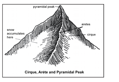
- Cirques are bowl shaped features at the head of a glacial valley. They have steep headwalls and a low threshold of rock or moraine. A tarn (lake) may fill a cirque after the glacier is gone. Cirques may begin in nivation basins where freeze thaw beneath a snow bank breaks up rock which is then removed by creep, solifluction, and rill wash, thereby hollowing out a depression. Bergschrund are large, very deep glacial crevasses near the headwall of a cirque- between the ice and headwall. Cirques are more common on north and east facing slopes in northern hemisphere because these sides remain cooler with less afternoon sunlight to melt the snow.
- Horns are steep faceted mountain peaks, sculpted and surrounded by three or more cirques and their steep headwalls.
- Arêtes are high, pinnacled ridges formed by cirques eroding each side of the ridge.
- Cols are low areas between higher stretches of a ridge (arête) where opposing cirques have started to cut through the ridge.
- Glacial Valleys have a characteristic parabolic shape, which vary from the prototypical deep, steep-sided, fat bottomed, U-shape valley, which forms in resistant bedrock, to wide shallow troughs, which form in less resistant bedrock.
Depositional Landforms
The unassorted coarse and fine debris dropped by the melting glaciers is called glacial till. Most of the rock fragments in till are angular to sub angularin form. Streams form by melting ice at the bottom, sides or lower ends of glaciers. Some amount of rock debris small enough to be carried by such melt water streams is washed down and deposited. Such Glaciofiuvial deposits are called outwash deposits.
Unlike till deposits, the outwash deposits are roughly stratified and assorted. The rock fragments in outwash deposits are somewhat rounded at their edges. Some of the depositional landforms are discussed below:
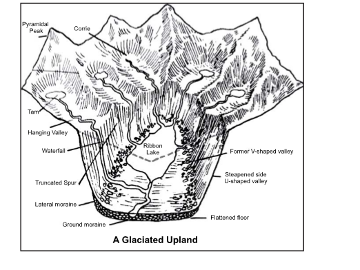
Moraines
-
- They are long ridges of deposits of glacial till. Terminal moraines are long ridges of debris deposited at the end (toe) of the glaciers.
- Lateral moraines form along the sides parallel to the glacial valleys. The lateral moraines may join a terminal moraine forming a horse-shoe shaped ridge.
- There can be many lateral moraines on either side in a glacial valley.
- These moraines partly or fully owe their origin to glaciofuvial waters pushing up materials to the sides of glaciers.
- Many valley glaciers retreating rapidly leave an irregular sheet of till over their valley floors. Such deposits varying greatly in thickness and in surface topography are called ground moraines.
- The moraine in the centre of the glacial valley flanked by lateral moraines is called medial moraine. They are imperfectly formed as compared to lateral moraines. Sometimes medial moraines are indistinguishable from ground moraines.
Drumlins
-
- These are elongate hills of lodgement till that are typically wider and higher in the direction from which the glaciers flowed. The elongation direction is parallel to the glacial flow direction.
Eskers
-
- When glaciers melt in summer, the water flows on the surface of the ice or seeps down along the margins or even moves through holes in the ice.
- These waters accumulate beneath the glacier and flow like streams in a channel beneath the ice. Such streams flow over the ground (not in a valley cut in the ground) with ice forming its banks.
- Very coarse materials like boulders and blocks along with some minor fractions of rock debris carried into this stream settle in the valley of ice beneath the glacier and after the ice melts can be found as a sinuous ridge called esker.
Outwash Plains
-
- The plains at the foot of the glacial mountains or beyond the limits of continental ice sheets are covered with glacio-fluvial deposits in the form of broad fat alluvial fans which may join to form outwash plains of gravel, silt, sand and clay.
Kettle
-
- When glaciers are rapidly retreating, numerous blocks of ice can become detached from the main body of the glacier. If glacial drift is then placed around the ice, a depression on the surface called a kettle hole can be created when the ice melts.
- Kettle holes are commonly found on moraine and outwash plain deposits. Large kettle holes that reach below the water table can form into lakes.
Char Dham Programme
Context
- Union Minister for Road Transport and Highways has informed Lok Sabha about the Char Dham Programme.
About
Char Dham Programme:
- The Char Dham programme is an initiative to improve connectivity to the Char Dham pilgrimage centres in the Himalayas namely Gangotri, Yamunotri, Kedarnath and Badrinath.
- These four ancient pilgrimages sites in Uttarakhand are known as Chota Char Dham to differentiate them from the bigger circuit of modern day Char Dham sites namely Badrinath, Dwarka, Puri and Rameswaram.
- The works under Char Dham Pariyojna are being implemented on Engineering Procurement and Construction (EPC) mode of contract.
- These projects are being implemented by three executing agencies of Ministry of Road Transport and Highways, viz,
- Uttarakhand State PWD,
- Border Road Organization(BRO) and
- National Highway & Infrastructure Development Corporation Limited (NHIDCL).
Features of the programme:
- The project proposes the widening of single lane roads into double lanes by up to 10 metres, developing highways in Uttarakhand and thereby improving access to the Char Dham.
- The projects also includes mitigation measures/ stabilisation of chronic landslide & sinking spots/zones as a standalone project or part of road widening projects to avoid landslide and safety of road users.
KALAPANI, A small area on the India map that bothers Nepal
Context
The new political map of India, recently released by the government to account for the bifurcation of Jammu and Kashmir, has triggered fresh protests over an old issue in Kathmandu.
About
- Kalapani is a 35 square kilometre area. The Kali River in the Kalapani region demarcates the border between India and Nepal.
- While the Nepal government and political parties have protested, India has said the new map does not revise the existing boundary with Nepal.
- The Nepal government described India’s decision as “unilateral” and claimed that it will “defend its international border”.
Defining the boundaries
- Nepal’s western boundary with India was marked out in the Treaty of Sugauli between the East India Company and Nepal in 1816.
- Nepali authorities claim that people living in the low-density area were included in the Census of Nepal until 58 years ago.
Danakil Depression
Context
- Nature Ecology & Evolution recently published a new study. It says that active and naturally occurring life cannot be sustained at Danakil Depression, a place having water.
About
Danakil Depression:
- The Danakil Depression is located in Ethiopia. It is the northern part of Afar Triangle there.
- It is a geological depression that has resulted from the divergence of three tectonic plates in the Horn of Africa.
- It is one of the lowest place in the surface of earth measuring 125m below sea level.
- It is the hottest place on Earth in terms of year-round average temperatures. It remains without rain for most of the year.
- At the northern end of Danakil Depression which is separated by live volcanoes from the Red Sea, this depression was formed by the evaporation of an inland water body. All the water entering Danakil evaporates, and no streams flow out from its extreme environment. It is covered with more than 10 lakh tonnes of salt.
Findings of the report:
- There are extremophile microbes that can adapt to environmental conditions that are too extreme for any living organism. This new research has pointed out that in Danakil Depression, a place having bubbling pools of water and mounds of salt covering its landscape, even these microorganisms cannot live.
- It identifies two barriers for this: magnesium-dominated brines that cause cells to break down; and an environment having simultaneously very low pH and high salt (toxic hyperacid-hypersaline water), a combination that makes adaptation highly difficult.
- The scientists have the opinion that the fact that this research has not revealed life form does not mean that organisms more complex than microfossils are not present there.
- They say that until more intricate studies are done, this Danakil Depression for now is the most inhospitable area not fit for living.
Utkarsh 2022

NIRVIK SCHEME

One Nation One FASTag

Periodic Labour Force

Overseas Sovereign Bond