Geography: Maps of India and the World
Maps of India and World
India
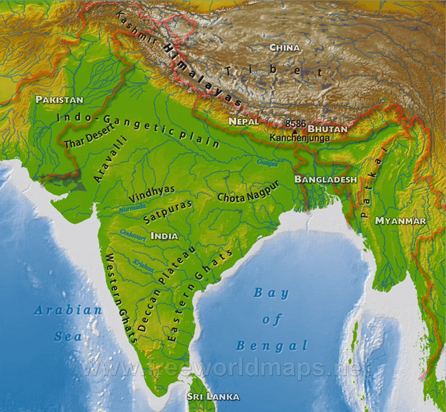
Important Facts about India
- India, officially the Republic of India is a country in South Asia.
- It is the seventh-largest country by area, the second-most populous country, and the most populous democracy in the world.
- Bounded by the Indian Ocean on the south, the Arabian Sea on the southwest, and the Bay of Bengal on the southeast, it shares land borders with Pakistan to the west; China, Nepal, and Bhutan to the north; and Bangladesh and Myanmar to the east.
- The longest boundary is shared by Bangladesh
- In the Indian Ocean, India is in the vicinity of Sri Lanka and the Maldives; it’s Andaman and Nicobar Islands share a maritime border with Thailand and Indonesia.
- The Tropic of Cancer passes through 8 states. States being Gujarat, Rajasthan, Chhattisgarh, Madhya Pradesh, Jharkhand, West Bengal, Mizoram and Tripura.
- 82° 30′ East is the Indian Standard Meridian, it passes through Mirzapur in Uttar Pradesh and touches five states of India. The states it passes through are Uttar Pradesh, Madhya Pradesh, Chhattisgarh, Orissa and Andhra Pradesh.
- Kanchenjunga is the third highest mountain in the world (after Mount Everest and K2) and the tallest peak in India, with an elevation of 8,586 metres (28,169 ft.).
- Kanchenjunga” which lies in the Himalayas means “The Five Treasures of Snows” translated, as it contains five peaks, four of them over 8,450 metres.
- The Ganges and its tributaries drain a 1,000,000-square-kilometer (390,000 sq mi) fertile basin that supports one of the world’s highest density of humans.
- The Ganges River’s long held reputation as a purifying river appears to have a basis in science. The river water has a unique and extraordinary ability to retain oxygen.
- Siachen Glacier is the largest glacier in India. At 75.6 km long and 2.8 km wide, it is the longest glacier in the Karakoram and second-longest in the world’s non-polar areas.
- Drass in western Ladakh is the coldest place in India. It is also the second coldest inhabited place in the world after Siberia.
- Varanasi, also known as Benaras, was called "the Ancient City" when Lord Buddha visited it in 500 B.C., and is the oldest, continuously inhabited city in the world today.
Geographical Facts Continent Wise
Asia
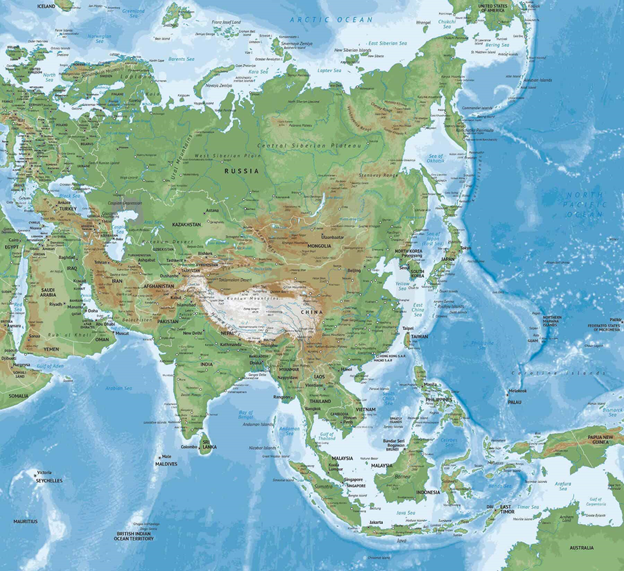
- Asia is the largest of the world’s continents, covering approximately 30 percent of the Earth’s land area. Asia is made up of 48 countries, as well as 6 non-UN states, and 6 dependent territories.
- Most geographers define Asia’s western border as an indirect line that follows the Ural Mountains, the Caucasus Mountains, and the Caspian and Black Seas.
- Asia is bordered by the Arctic, Pacific, and Indian Oceans.
Mountain Systems
- The Himalaya Mountains extend for about 2,500 kilometers (1,550 miles), separating the Indian subcontinent from the rest of Asia.
- The Indian subcontinent is still crashing northward into Asia, and the Himalayas are growing about 5 centimeters (2 inches) every year.
- The Tien Shan mountain system stretches for about 2,400 kilometers (1,500 miles), straddling the border between Kyrgyzstan and China. The name Tien Shan means “Celestial Mountains” in Chinese.
- The two highest peaks in the Tien Shan are Victory Peak, which stands at 7,439 meters (24,406 feet), and Khan Tängiri Peak, which stands at 6,995 meters (22,949 feet).
- The Ural Mountains run for approximately 2,500 kilometers (1,550 miles) in an indirect north-south line from Russia to Kazakhstan.
Plateaus
- Asia is home to many plateaus, areas of relatively level high ground. The Iranian plateau covers more than 3.6 million square kilometers (1.4 million square miles), encompassing most of Iran, Afghanistan, and Pakistan.
- The Deccan Plateau makes up most of the southern part of India. It is bordered by three mountain ranges: the Satpura Range in the north, and the Eastern and Western Ghats on either side.
- The Tibetan Plateau is usually considered the largest and highest area ever to exist in the history of Earth. Known as the “Rooftop of the World,” the plateau covers an area about half the size of the contiguous United States and averages more than 5,000 meters (16,400 feet) above sea level.
- Tibetan Plateau is extremely important to the world’s water cycle because of its tremendous number of glaciers.
Plains, Steppes, and Deserts
- The West Siberian Plain, located in central Russia, is considered one of the world’s largest areas of continuous flatland.
- Central Asia is dominated by a steppe landscape, a large area of flat, unforested grassland.
- The Rub’ al Khali desert, considered the world’s largest sand sea, covers an area larger than France across Saudi Arabia, Oman, the United Arab Emirates, and Yemen.
- It holds roughly half as much sand as Africa’s Sahara desert, even though it is 15 times smaller in size.
- The desert is known as the Empty Quarter because it is virtually inhospitable to humans except for Bedouin tribes that live on its edges.
Freshwater
- Lake Baikal, located in southern Russia, is the deepest lakein the world
- The lake contains 20 percent of the world’s unfrozen freshwater, making it the largest reservoir on Earth.
- It is also the world’s oldest lake, at 25 million years old.
- The Yangtze is the longest river in Asia and the third longest in the world.
- The Tigris and Euphrates Rivers begin in the highlands of eastern Turkey and flow through Syria and Iraq, joining in the city of Qurna, Iraq, before emptying into the Persian Gulf.
Saltwater
- The Persian Gulf has an area of more than 234,000 square kilometers (90,000 square miles). It borders Iran, Oman, United Arab Emirates, Saudi Arabia, Qatar, Bahrain, Kuwait, and Iraq.
- The seabed beneath the Persian Gulf contains an estimated 50 percent of the world’s oil reserves.
- The Sea of Okhotsk covers 1.5 million square kilometers (611,000 square miles) between the Russian mainland and the Kamchatka Peninsula.
- The Bay of Bengal is the largest bay in the world, covering almost 2.2 million square kilometers (839,000 square miles) and bordering Bangladesh, India, Sri Lanka, and Burma.
- Many large rivers, including the Ganges and Brahmaputra, empty into the bay. The briny wetland formed by the Ganges-Brahmaputra on the Bay of Bengal is the largest delta in the world.
Africa
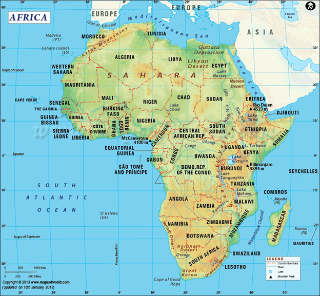
- Africa, the second largest continent (after Asia), covering about one-fifth of the total land surface of Earth.
- The continent is bounded on the west by the Atlantic Ocean, on the north by the Mediterranean Sea, on the east by the Red Sea and the Indian Ocean, and on the south by the mingling waters of the Atlantic and Indian oceans.
- There are 54 countries and one “non-self-governing territory”, the Western Sahara, in Africa.
- All of Africa was colonized by foreign powers during the “scramble for Africa”, except Ethiopia and Liberia.
- African continent is the world’s oldest populated area.
- Its northern extremity is Al-Ghiran Point, near Al-Abyad Point (Cape Blanc), Tunisia; its southern extremity is Cape Agulhas, South Africa; its farthest point east is Xaafuun (Hafun) Point, near Cape Gwardafuy (Guardafui), Somalia; and its western extremity is Almadi Point (Pointe des Almadies), on Cape Verde (Cap Vert), Senegal.
- In the northeast, Africa was joined to Asia by the Sinai Peninsula until the construction of the Suez Canal.
- Paradoxically, the coastline of Africa—18,950 miles (30,500 km) in length—is shorter than that of Europe, because there are few inlets and few large bays or gulfs.
- Off the coasts of Africa a number of islands are associated with the continent. Of these Madagascar, one of the largest islands in the world is the most significant.
- Other, smaller islands include the Seychelles, Socotra, and other islands to the east; the Comoros, Mauritius, Réunion, and other islands to the southeast; Ascension, St. Helena, and Tristan da Cunha to the southwest; Cape Verde, the Bijagós Islands, Bioko, and São Tomé and Príncipe to the west; and the Azores and the Madeira and Canary islands to the northwest.
- The continent is cut almost equally in two by the Equator, so that most of Africa lies within the tropical region bounded on the north by the Tropic of Cancer and on the south by the Tropic of Capricorn. Because of the bulge formed by western Africa, the greater part of Africa’s territory lies north of the Equator.
- Africa is crossed from north to south by the prime meridian (0° longitude), which passes a short distance to the east of Accra, Ghana.
- The whole of Africa can be considered as a vast plateau rising steeply from narrow coastal strips and consisting of ancient crystalline rocks.
- The plateau’s surface is higher in the southeast and tilts downward toward the northeast.
- The northwestern part, which includes the Sahara (desert) and that part of North Africa known as the Maghrib, has two mountainous regions—the Atlas Mountains in northwestern Africa, which are believed to be part of a system that extends into southern Europe, and the Ahaggar (Hoggar) Mountains in the Sahara.
- The southeastern part of the plateau includes the Ethiopian Plateau, the East African Plateau, and—in eastern South Africa, where the plateau edge falls downward in a scarp—the Drakensberg range.
- One of the most remarkable features in the geologic structure of Africa is the East African Rift System, which lies between 30° and 40° E.
- The rift itself begins northeast of the continent’s limits and extends southward from the Ethiopian Red Sea coast to the Zambezi River basin.
- The East African Rift System constitutes the most striking and distinctive relief feature of the continent. Associated with its formation was the volcanic activity responsible for most of the higher peaks of East Africa, including Kilimanjaro. Seismic and volcanic disturbances are still recorded in the western portions of the rift valley system.
- In the Virunga Mountains, northeast of Lake Kivu, there are periodic outbursts (about every 10 or 12 years) that have created a series of lava flows.
- One of these volcanoes dammed the rift valley and converted a large area, formerly drained by a tributary of the Nile, into Lake Kivu.
- Kilimanjaro (19,340 feet [5,895 metres]) is the highest point on the continent; the lowest is Lake Assal (515 feet [157 metres] below sea level) in Djibouti.
North America
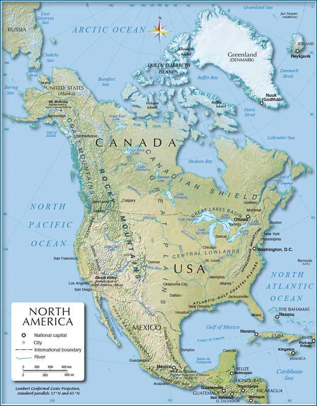
- North America, the third-largest continent, extends from the tiny Aleutian Islands in the northwest to the Isthmus of Panama in the south.
- The continent includes the enormous island of Greenland in the northeast and the small island countries and territories that dot the Caribbean Sea and western North Atlantic Ocean.
- In the far north, the continent stretches halfway around the world, from Greenland to the Aleutians.
- But at Panama’s narrowest part, the continent is just 50 kilometers (31 miles) across.
Western Region
- Young mountains rise in the west. The most familiar of these mountains are probably the Rockies, North America’s largest chain. The Rockies stretch from the province of British Columbia, Canada, to the U.S. state of New Mexico.
- The Rocky Mountains are part of a system of parallel mountain ranges known as the Cordilleras. A cordillera is a long series of mountain ranges. Although cordilleras exist all over the world, in North America, “the Cordilleras” indicate the massive mountain ranges in the western part of the continent. The Cordilleras extend from Canada all the way to the Isthmus of Panama.
- The Sierra Madre mountain system is part of the Cordilleras. The Sierra Madre stretch from the southwestern United States to Honduras. The Sierra Madre include many high volcanoes (up to 5,636 meters, or 18,500 feet) that stretch across Mexico south of the cities of Guadalajara and Mexico City.
- Volcanic mountain ranges in Guatemala, Honduras, Nicaragua, Costa Rica, and Panama are also considered part of the Cordilleras.
- Some of the Earth’s youngest mountains are in the Cascade Range of the U.S. states of Washington, Oregon, and California.
- The three major desert regions of North America—the Sonoran, Mojave, and Chihuahuan—are all in the American southwest and northern Mexico. These large deserts are located in the rain shadows of nearby mountains. The mountains block precipitation and accelerate the movement of hot, dry wind over these regions.
- The Sonoran is in the rain shadow of the Coast Ranges, the Mojave is in the shadow of the Sierra Nevada, and the Chihuahuan is in the shadow of the Sierra Madre.
Great Plains
- The Great Plains lie in the middle of the continent.
- Deep, rich soil blankets large areas of the plains in Canada and the United States.
- Grain grown in this region, called the “Breadbasket of North America,” feeds a large part of the world. The Great Plains are also home to rich deposits of oil and natural gas.
- The grassland or prairie regions of the Great Plains make up the largest biome in North America.
Canadian Shield
- The Canadian Shield is a raised but relatively flat plateau. It extends over eastern, central, and northwestern Canada. The Canadian Shield is characterized by a rocky landscape pocked by an astounding number of lakes.
- The tundra, stretching along the northern borders of Alaska and Canada to the Hudson Bay area, is a biome common to the Canadian Shield.
- The Eastern region includes the Appalachian Mountains and the Atlantic coastal plain.
- North America’s older mountain ranges, including the Appalachians, rise near the east coast of the United States and Canada. These areas have been mined for rich deposits of coal and other minerals for hundreds of years.
Caribbean Region
- The Caribbean Region includes more than 7,000 islands, islets, reefs, and cays. The region’s islands and smaller islets are varied in their topography; some have relatively flat and sandy terrain while others are rugged, mountainous, and volcanic.
- The coral reefs and cays of the Caribbean Sea are among the most spectacular biomes in North America.
South America
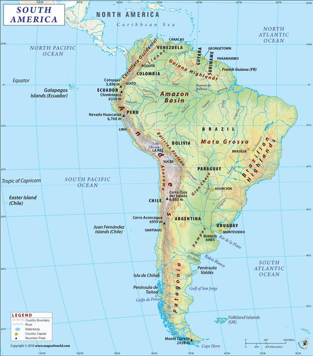
- South America, the fourth-largest continent, extends from the Gulf of Darién in the northwest to the archipelago of Tierra del Fuego in the south.
- South America’s extreme geographic variation contributes to the continent’s large number of biomes.
Mountains & Highlands
- South America’s primary mountain system, the Andes, is also the world’s longest. The range covers about 8,850 kilometers (5,500 miles). Situated on the far western edge of the continent, the Andes stretch from the southern tip to the northernmost coast of South America. There are hundreds of peaks more than 4,500 meters (15,000 feet) tall, many of which are volcanic.
- The highest peak in the Andes, Aconcagua, stands at 6,962 meters (22,841 feet) and straddles the Argentina-Chile border.
- Aconcagua is the tallest mountain outside Asia.
- The largest herb in the world, Puya raimondii, is known as the Queen of the Andes.
- A Puya raimondii can live for 100 years and can grow to more than 9 meters (30 feet) tall.
- The leaves of this endangered species all grow from one woody stem, allowing moisture to run down the leaves to the base of the plant.
- Outside the Andes, South America has two principal highland areas: the Brazilian Highlands and the Guiana Highlands.
- Located south of the Amazon River in Brazil, the Brazilian Highlands are made up of low mountains and plateaus that rise to an average elevation of 1,006 meters (3,300 feet).
- The Guiana Highlands are located between the Amazon and Orinoco Rivers. The heavily forested plateau of the Guiana Highlands covers southern Venezuela, French Guiana, Guyana, northern Brazil, and a portion of southeastern Colombia.
River Basins
- South America has three important river basins: the Amazon, Orinoco, and Paraguay/Paraná.
- The Amazon River basin has an area of almost 7 million square kilometers (2.7 million square miles), making it the largest watershed in the world.
- The basin, which covers most of northern South America, is fed by tributaries from the glaciers of the Andes. Every second, the Amazon River empties 209,000 cubic meters (7,381,000 cubic feet) of freshwater into the Atlantic Ocean.
- The Amazon River is the life force of the equally vast Amazon rain forest, which makes up about half of the rain forest of the entire planet.
- The Orinoco River flows north of the Amazon. The Orinoco flows in a giant arc for more than 2,736 kilometers (1,700 miles), originating in the Guiana Highlands of northern Brazil and discharging in the Atlantic Ocean in Venezuela.
- A vast savanna or grassland region, known as the Llanos, is the primary biome of the Orinoco River basin.
- The Llanos is primarily made up of grasses. Swamp grasses, sedges, and bunchgrass are found in wet, low-lying areas. Carpet grass is found in the higher and drier elevations.
- The Paraguay/Paraná River basin covers almost 2.8 million square kilometers (1,081,000 square miles), which is much of southeastern Brazil and Bolivia, Paraguay, and northern Argentina. The Paraná River includes Iguazu Falls, a massive series of waterfalls that extend for 2.7 kilometers (1.7 miles).
Coastal Plains
- South American coastal plains are found on the northeastern coast of Brazil, on the Atlantic Ocean, and the western, Pacific coast of Peru and Chile.
- The coastal plains of northeastern Brazil are extremely dry. The Brazilian Highlands act as a wedge that pushes moist sea winds away from the coastal plains.
- The Atacama Desert is part of the western coastal plain. The Atacama is considered the driest region in the world.
- The average rainfall is about 1 millimeter (0.04 inches) a year, and some parts of the Atacama have never had rain in recorded history.
Europe
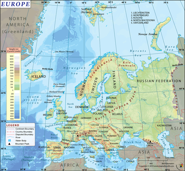
- Europe is the second-smallest continent.
- Europe extends from the island nation of Iceland in the west to the Ural Mountains of Russia in the east.
- Europe’s northernmost point is the Svalbard archipelago of Norway, and it reaches as far south as the islands of Greece and Malta.
- Europe is sometimes described as a peninsula of peninsulas.
- Europe is a peninsula of the Eurasian supercontinentand is bordered by the Arctic Ocean to the north, the Atlantic Ocean to the west, and the Mediterranean, Black, and Caspian Seas to the south.
- Europe’s main peninsulas are the Iberian, Italian, and Balkan, located in southern Europe, and the Scandinavian and Jutland, located in northern Europe.
Western Uplands
- The Western Uplands, also known as the Northern Highlands, curve up the western edge of Europe and define the physical landscape of Scandinavia (Norway, Sweden, and Denmark), Finland, Iceland, Scotland, Ireland, the Brittany region of France, Spain, and Portugal.
- The Western Uplands is defined by hard, ancient rock that was shaped by glaciation.
North European Plain
- The North European Plain extends from the southern United Kingdom east to Russia.
- It includes parts of France, Belgium, the Netherlands, Germany, Denmark, Poland, the Baltic states (Estonia, Latvia, and Lithuania), and Belarus.
- It is home to many navigable rivers, including the Rhine, Weser, Elbe, Oder, and Vistula.
- The North European Plain remains the most densely populated region of Europe.
Central Uplands
- The Central Uplands extend east-west across central Europe and include western France and Belgium, southern Germany, the Czech Republic, and parts of northern Switzerland and Austria.
- Important highlands in this region include the Massif Central and the Vosges in France, the Ardennes of Belgium, the Black Forest and the Taunus in Germany, and the Ore and Sudeten in the Czech Republic.
- This region is sparsely populated except in the Rhine, Rhne, Elbe, and Danube river valleys.
Alpine Mountains
- The Alpine Mountains include ranges in the Italian and Balkan peninsulas, northern Spain, and southern France.
- The region includes the mountains of the Alps, Pyrenees, Apennines, Dinaric Alps, Balkans, and Carpathians.
- Europe’s highest peak, Mount Elbrus (5,642 meters/18,510 feet), is in the Caucasus Mountains of Russia.
- The Alpine region also includes active volcanoes, such as Mount Etna and Mount Vesuvius in Italy.
Australia
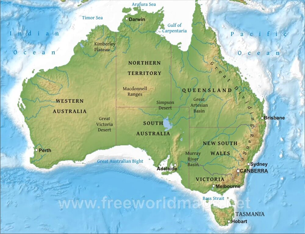
- Australia, the smallest continent and one of the largest countries on Earth, lying between the Pacific and Indian oceans in the Southern Hemisphere.
- Australia’s capital is Canberra, located in the southeast between the larger and more important economic and cultural centres of Sydney and Melbourne.
- Australia is both the flattest continent and, except for Antarctica, the driest.
- Australia has been called “the Oldest Continent,” “the Last of Lands,” and “the Last Frontier.”
- The red and black soil plains of Queensland and New South Wales have long supported the world’s greatest wool industry, and some of the most arid and forbidding areas of Australia conceal great mineral wealth.
- In particular the east coast, where European settlement began and where the majority of Australians now live, is topographically quite diverse and is comparatively well watered and fertile.
- Inland from the coast runs a chain of highlands, known as the Great Dividing Range, from Cape York in northern Queensland to the southern seaboard of Tasmania.
Overall characteristics
- Australia is a land of vast plains. Only 6 percent of the island continent is above 2,000 feet (600 metres) in elevation. Its highest peak, Mount Kosciuszko, rises to only 7,310 feet (2,228 metres).
- Australia is an arid continent; fully one-third of its area is occupied by desert, another third is steppe or semidesert, and only in the north, east, southeast, and southwest is precipitation adequate to support vegetation that significantly protects the land surface from weathering.
- Permanently flowing rivers are found only in the eastern and southwestern regions and in Tasmania.
- The major exception is the Murray River, a stream that rises in the Mount Kosciuszko area in the Eastern Uplands and is fed by melting snows.
- All other rivers in Australia are seasonal or intermittent in their flow, and those of the arid interior are episodic.
- The western half of Australia consists of the Western Plateau, which rises to mountain heights near the west coast and falls to lower elevations near the continental centre.
- The Western Plateau region is generally flat, though broken by various mountain ranges such as the Hamersley Range, the MacDonnell Ranges, and the Musgrave Range. Surface water is generally lacking in the Western Plateau, although there are several larger rivers in the west and north, such as the Murchison, Ashburton, and Victoria Rivers.
- Off the eastern coast of Australia is the world's largest coral reef complex, the Great Barrier Reef.
- The large and mountainous island of Tasmania, also a State of Australia, lies south of the south-eastern corner of the Australian mainland. It receives abundant rainfall, and has highly fertile soils particularly in comparison to the mainland.
Antarctica
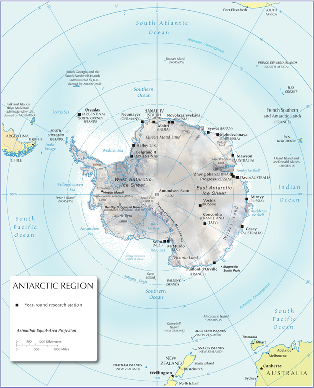
- The continent of Antarctica makes up most of the Antarctic region.
- The Antarctic is a cold, remote area in the Southern Hemisphere encompassed by the Antarctic Convergence.
- The Antarctic Convergence is an uneven line of latitude where cold, northward-flowing Antarctic waters meet the warmer waters of the world’s oceans.
- The Antarctic covers approximately 20 percent of the Southern Hemisphere.
- Antarctica is the fifth-largest continent in terms of total area. (It is larger than both Oceania and Europe.)
- Antarctica is a unique continent in that it does not have a native population.
- There are no countries in Antarctica, although seven nations claim different parts of it: New Zealand, Australia, France, Norway, the United Kingdom, Chile, and Argentina
Physical Geography
- The Antarctic Ice Sheet dominates the region.
- It is the largest single piece of ice on Earth.
- This ice sheet even extends beyond the continent when snow and ice are at their most extreme.
- Antarctica has a number of mountain summits, including the Transantarctic Mountains, which divide the continent into eastern and western regions.
- Without any ice, Antarctica would emerge as a giant peninsula and archipelago of mountainous islands, known as Lesser Antarctica, and a single large landmass about the size of Australia, known as Greater Antarctica.
Naming of Cyclones
Context
- The recent cyclone to emerge out of the Bay of Bengal was named Fani. It has made landfall in Odisha causing the most destruction in 2 cities- Puri and Bhubhneshwar.
- Before this, there were cyclones Hudhud in 2014, Ockhi in 2017 and Titli and Gaja in 2018.
- The first cyclone after the list was adopted was given the name in the first row of the first column — Onil, proposed by Bangladesh. The next cyclone will have name- Vayu.
About
Naming of cyclones:
- Each Tropical Cyclone basin in the world has its own rotating list of names.
- For cyclones in the Bay of Bengal and Arabian Sea, the naming system was agreed by eight member countries of a group called WMO/ESCAP and took effect in 2004.
- These eight countries are – Bangladesh, India, Maldives, Myanmar, Oman, Pakistan, Sri Lanka and Thailand.
- The first cyclone after the list was adopted was given the name in the first row of the first column — Onil, proposed by Bangladesh.
- Subsequent cyclones are being named sequentially, column-wise, with each cyclone given the name immediately below that of the previous cyclone.
- Once the bottom of the column is reached, the sequence moves to the top of the next column.
- So far, the first seven columns have been exhausted, and Fani (again proposed by Bangladesh) is the top name in the last column.
- The next cyclone will be named Vayu. When all the names in list are exhausted, the eight countries will propose fresh lists of names.
- The lists for storms in the Atlantic and Eastern Pacific basins are, however, rotated when the names in the list get exhausted. Exception are, however, made in certain cases — if a storm causes excessive death and destruction, its name is considered for retirement and is not repeated; it is replaced with another name.
Why naming of cyclones is done?
- Appending names to cyclones makes it easier for the media to report on these cyclones, heightens interest in warnings, and increases community preparedness.
- Names are easier to remember than numbers and technical terms and hence can reach greater masses.
- If public wants to suggest the name of a cyclone to be included in the list, the proposed name must meet some fundamental criteria. The name should be short and readily understood when broadcast. Further, the names must not be culturally sensitive and should not convey any unintended and potentially inflammatory meaning.
Disaster resilience in risk-prone Asia needs realistic policy and financial planning
Context
- As per new Asian Development Bank (ADB) report four in five people affected by natural disasters are in Asia, putting the region’s prosperity at risk.
About
- The report is published under ADB’s flagship Asian Development Outlook (ADO) 2019. It released ahead of the biennial global platform for Disaster Risk Reduction (DRR) scheduled in May 2019 — is very well-timed and deserves to be discussed on behalf of the Asian nations to strengthen disaster resilience in the region.
- Over the past three decades, natural disasters have affected over 10 million people throughout the Central Asian region and caused economic losses of almost $2.5 billion. In this backdrop, experts from the Central Asian countries also agreed on increasing financial protection against natural disasters at a regional forum on Disaster Risk Financing held at Almaty in February 2019.
Key Findings:
- With nearly 38,000 disaster fatalities per year between 2000 and 2018, the region accounted for 55 per cent of the 60,000 disaster fatalities across the world.
- The region also accounted for 26 per cent of the $128 billion in economic damage due to natural disasters.
- In Asia, 82 per cent of the disasters ensued from extreme weather events such as floods, storms and droughts.
Who suffers the most?
- It has been recognised that the poor suffer the maximum brunt of natural catastrophes.
- A survey conducted across five Asian countries found that, among the rural households surveyed, 90 per cent suffered either loss of life or significant damage to assets from floods in the past decade, and their financial recovery took more than three times longer compared to urban households.
- The ADB report highlights case studies from Indian cities like Mumbai, Chennai and Puri, which show that in the absence of social protection; disaster-hit families deplete their savings or borrow at high interest rates from informal sources, pushing them into indebtedness and poverty traps.
Way Forward:
- a) Funding needed to strengthen disaster resilience
- Asia is projected to need $26 trillion in infrastructure investment between 2016 and 2030, or $1.7 trillion per year.
- Hence, planning for and investing in climate-friendly and disaster-resilient infrastructure from the start will be a cost-effective way to reduce future losses.
- The report calls upon the international agencies for more financial support.
- At present, international agencies provide seven times more assistance to the developing countries to respond to disasters after they occur, than fund preparation programmes beforehand.
- Even though many countries in the region are adapting the Sendai Framework for Disaster Risk Reduction 2015-2030, the increasingly high losses from such disasters need effective actions too.
- It also urges governments in the region to work on realistic policy and budget planning.
- It suggests that Asian nations integrate disaster risk reduction into national development and investment plans, and spend more on prevention.
b) Insurance against catastrophes
- According to the report, although climate change is spurring more natural hazards and rapid urbanisation is increasing exposure to such hazards, only around 8 per cent of Asia’s catastrophe losses since 1980 have been covered by insurance.
- Many developing countries in Asia now boast of multiple disaster insurance schemes, including 15 in India, but effectiveness of such schemes needs to be prioritised.
- In fact, Southeast Asia Disaster Risk Insurance Facility (SEADRIF) — Asia’s first regional facility to provide climate and disaster risk financing and insurance solutions, including a regional catastrophe risk insurance pool — was established nearly four months ago.
Colour Coded Weather Warning
Context
- Recently Indian Meteorological Department issued a yellow weather warning for rain in Himachal Pradesh.
- The weather department forecast thunderstorm with hail in isolated places of mid hills, including Shimla, Mandi, Kullu, Chamba, Solan and Sirmaur.
About
Colour coded weather warning:
- It is issued by the country’s apex weather agency Indian Meteorological Department (IMD) from Ministry of Earth Sciences.
- Its objective is to alert people ahead of severe or hazardous weather which has the potential to cause damage, widespread disruption or danger to life.
- As per the regular practice, warnings are uploaded in the website every day. District wise rainfall forecast along with warnings with colour coded alerts are also uploaded and updated thrice daily in the website.
Four colour codes:
The Four colour codes are issued to indicate various categories of warnings. The meanings of these codes are:
Red:
- Take action.
- Extremely bad weather is expected.
- People need to take action to keep themselves and others safe.
- Widespread damage, travel and power disruption and risk to life are likely. People must avoid dangerous areas and follow the advice of the emergency services and local authorities.
Amber:
- Be prepared.
- There is an increased likelihood of extremely bad weather, which could potentially cause travel delays, road and rail closures, and interruption of power supply.
- Amber means people need to be prepared to change plans and protect themselves, their family and community from the impacts of the severe weather based on the forecast from the Met Office.
- There could be risk to life and property.
Yellow:
- Be updated.
- Severely bad weather is possible over the next few days, plan ahead thinking about possible travel delays and disruption of day-to-day activities possible.
- It indicates the weather may change or worsen in the next few days.
Green:
- No action required.
- No severe weather concerns.
- No advisory is issued.
Maharaja Ranjit Singh

Lal Bahadur Shastri

Chaukhandi Stupa

Amaravati School of Art

Chamliyal Mela