

14th May 2025 (12 Topics)
1
May
2
May
3
May
5
May
6
May
7
May
8
May
9
May
10
May
12
May
13
May
14
May
15
May
16
May
17
May
19
May
20
May
21
May
22
May
23
May
24
May
26
May
27
May
28
May
29
May
30
May
31
May
Cyclonic Circulation lay over Andaman Sea
Context
The India Meteorological Department (IMD) recently announced the onset of the southwest monsoon over parts of the south Bay of Bengal and Andaman Sea. At the same time, meteorological signals are emerging that hint at a possible cyclone developing (Cyclone Shakti) over the Bay of Bengal. Though not yet confirmed, multiple systems—such as upper air cyclonic circulations and likely low-pressure areas—are forming, which could influence monsoon dynamics and weather patterns across the Indian subcontinent.
Key-highlights
- Southwest Monsoon Onset: The Southwest Monsoon, critical for India’s agriculture, has advanced into parts of the Bay of Bengal and Andaman Sea, signaling the start of its annual progression over the subcontinent.
- The northern limit of monsoon (NLM) is now traced through key coordinates, and further advancement is likely soon.
- Cyclonic Activity Over Bay of Bengal: A cyclonic circulation has been observed in the upper atmospheric layers over the Andaman Sea.
- IMD and regional meteorological centers are monitoring the formation of a low-pressure area, a precursor to potential cyclone development.
- A Bangladeshi meteorologist has forecasted the potential intensification into a full-fledged cyclone later in May, possibly to be named Cyclone ‘Shakti’.
- Widespread Weather Disturbances: Several upper air circulations have formed over northern and eastern India, influencing rainfall and thunderstorm patterns across states like Punjab, Delhi, Rajasthan, and the Northeast.
- The influence of these systems is expected to bring rainfall with thunder, lightning, and gusty winds in different regions, especially in northeast and southern India.
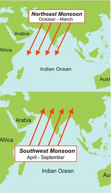
Southwest Monsoon:
- The Southwest Monsoon is the chief rainy season for the country.
- Over 70 per cent of the country receives the majority of its annual rainfall during the June to September season.
- Every year, the monsoon winds first arrive over the Andaman Sea and the Bay of Bengal around the third week of May and further progress into mainland India.
- Onset and progress: IMD declares the monsoon onset over India when it hits Kerala, where the normal onset date is June 1. Through June and mid-July, the monsoon brings continuous rainfall before covering the entire country by around July 15. This year, the monsoon onset over Kerala is expected to be early by 5 days and would be around May 27.
- Why Does the Monsoon Occur?
- Differential Heating of Land and Sea:During summer, the land (especially North India) heats up faster than the sea. This creates a low-pressure zone over land and high pressure over the Indian Ocean. Moisture-laden winds from the ocean move toward the land to fill this void.
- Inter-Tropical Convergence Zone (ITCZ):The ITCZ is a belt of low pressure near the equator where trade winds converge. In Indian summer, the ITCZ shifts northward (near the Tropic of Cancer) because the northern hemisphere is tilted toward the Sun. This pulls monsoon winds deep into the Indian subcontinent.
- Coriolis Force:Due to Earth’s rotation, the winds deflect to the right in the northern hemisphere. This turns the southeast trade winds into southwest monsoon winds over India.
- Other Climatic Factors Affecting Monsoon
- El Niño:Warming in central/east Pacific Ocean. It weakens Indian monsoon (can cause droughts)
- La Niña:Cooling in the Pacific. It strengthens monsoon
- Indian Ocean Dipole (IOD):Positive IOD (warmer west Indian Ocean). It enhances monsoon
- Equatorial Indian Ocean Oscillation: Affects monsoon build-up and variability
- Western Disturbances:Interact with monsoon and winter weather over North India
More Articles