

14th September 2024 (8 Topics)
2
Sep
3
Sep
4
Sep
5
Sep
6
Sep
7
Sep
9
Sep
10
Sep
11
Sep
12
Sep
13
Sep
14
Sep
16
Sep
17
Sep
18
Sep
19
Sep
20
Sep
21
Sep
23
Sep
24
Sep
25
Sep
26
Sep
27
Sep
28
Sep
30
Sep
Disengagement at four places in eastern Ladakh
Context
China recently announced that its troops have disengaged (process where military forces pull back or withdraw from positions they occupied) from four locations in eastern Ladakh, including the Galwan Valley.
Locations of Disengagement
The disengagement has occurred in the following four areas in eastern Ladakh:
- Galwan Valley: The Galwan river valley is strategically located between Ladakh in the west and Aksai Chin in the east, which is currently controlled by China as part of its Xinjiang Uyghur Autonomous Region.
- Galwan River has its source in Aksai Chin, on China’s side of the LAC, and it flows from the east to Ladakh, where it meets the Shyok river on India’s side of the LAC.
- The LAC lies east of the confluence of the Galwan and Shyok rivers in the valley.
- At its western end are the Shyok river and the Darbuk-Shyok-Daulet Beg Oldie (DSDBO) road. Its eastern mouth lies not far from China’s vital Xinjiang Tibet road, now called the G219 highway.
- Galwan River has its source in Aksai Chin, on China’s side of the LAC, and it flows from the east to Ladakh, where it meets the Shyok river on India’s side of the LAC.
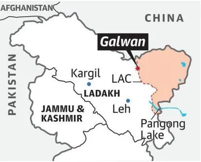
- Pangong Lake (North and South Banks): Pangong Lake, situated at a height of almost 4,350m, is the world's highest saltwater lake.
- Extending to almost 160km, one-third (45 km) of the Pangong Lake lies in India and the other two-thirds in China. The Line of Actual Control (LAC) passes through the lake, and both countries have conflicting claims over the territory surrounding it.
- It is accessible via a high-altitude mountain pass, the Chang La, which is one of the highest motorable passes in the world.
- Khurnak Fort lies on the northern shore of Pangong Tso and has been in Chinese-held territory since 1958. Before 1958, the boundary between India and China was considered at the Khurnak Fort but the latter has wrested control since then
- Gogra and Hot Spring: Both Hot Spring (PP15) and Gogra (PP17A) are part of the 65 patrolling points along the Line of Actual Control (LAC) in Ladakh.
- PP15 is located in an area known as the Hot Springs, while PP17A is near an area called the Gogra post.
- Both of these are close to the Chang Chenmo river in the Galwan sub-sector of the LAC in eastern Ladakh.
- While Hot Springs is just north of the Chang Chenmo river, Gogra Post is east of the point where the river takes a hairpin bend coming southeast from Galwan Valley and turning southwest.
- The area is north of the Karakoram Range of mountains, which lies north of the Pangong Tso lake, and south east of Galwan Valley.
|
Fact box:
|
More Articles