
10th February 2022 (6 Topics)
Context
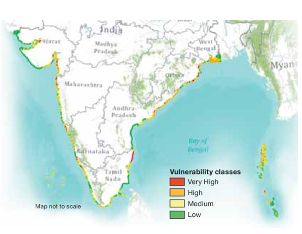
Indian National Centre for Ocean Information Services (INCOIS) has carried out coastal vulnerability assessment for entire Indian coast.
About
About Coastal Vulnerability Index (CVI):
- The Coastal Vulnerability Index (CVI) is one of the simplest and commonly used methods to assess coastal vulnerability to sea-level rise (SLR) driven erosion and/or inundation.
- It is a common tool contributing to the decision-making process in long-term coastal planning and management.
- Under the CVI, INCOIS has brought out an Atlas comprising 156 maps on 1:1,00,000 scales to prepare a CVI.
- These maps determine the coastal risks due to future sea-level rise based on the physical and geological parameters for the Indian coast.
Parameters
- The CVI uses the relative risk that physical changes will occur as sea-level rises are quantified based on parameters like:
- tidal range
- wave height
- coastal slope
- coastal elevation
- shoreline change rate
- geomorphology
- historical rate of relative sea-level change
- From this CVI, it can be outlined that 124 km of Gujarat, 11 km of Maharashtra, 48 km of Karnataka and Goa, 15 km of Kerala, 65 Km of Tamil Nadu, 6 km of Andhra Pradesh, 37 km of Odisha, 49 km of West Bengal, 1 km of Lakshadweep, 24 km of Andaman Islands and 8 km of Nicobar islands coastline would be affected.
|
About Indian National Centre for Ocean Information Services (INCOIS):
|


